Bridge Statistics for Dothan, Alabama (AL)
Condition, Traffic, Stress, Structural Evaluation, Project Costs
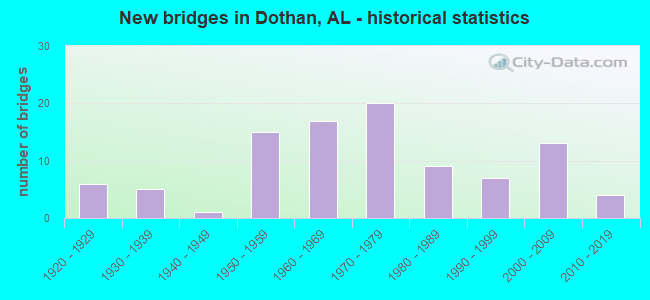
- New bridges - historical statistics
- 61920-1929
- 51930-1939
- 11940-1949
- 151950-1959
- 171960-1969
- 201970-1979
- 91980-1989
- 71990-1999
- 132000-2009
- 42010-2019
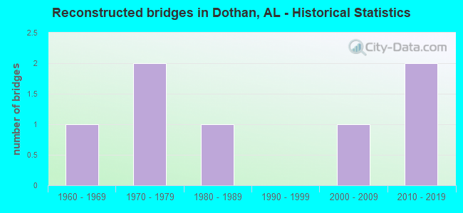
- Reconstructed bridges - Historical Statistics
- 11960-1969
- 21970-1979
- 11980-1989
- 01990-1999
- 12000-2009
- 22010-2019
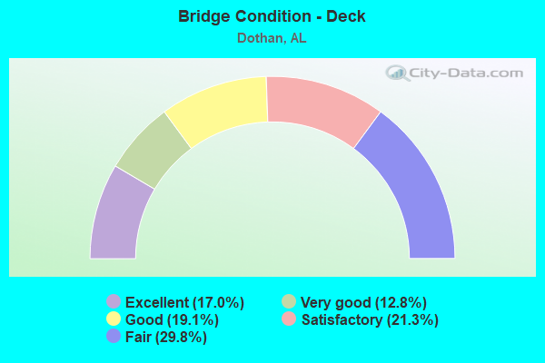
- Bridge Condition - Deck
- 17.0%Excellent
- 12.8%Very good
- 19.1%Good
- 21.3%Satisfactory
- 29.8%Fair
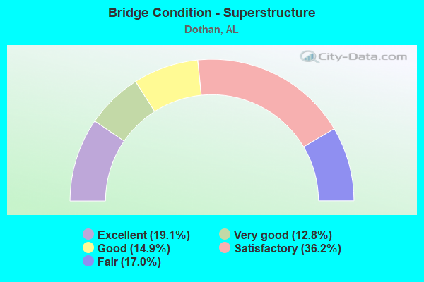
- Bridge Condition - Superstructure
- 19.1%Excellent
- 12.8%Very good
- 14.9%Good
- 36.2%Satisfactory
- 17.0%Fair
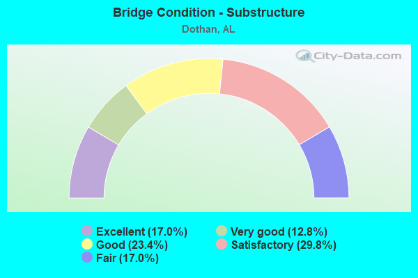
- Bridge Condition - Substructure
- 17.0%Excellent
- 12.8%Very good
- 23.4%Good
- 29.8%Satisfactory
- 17.0%Fair
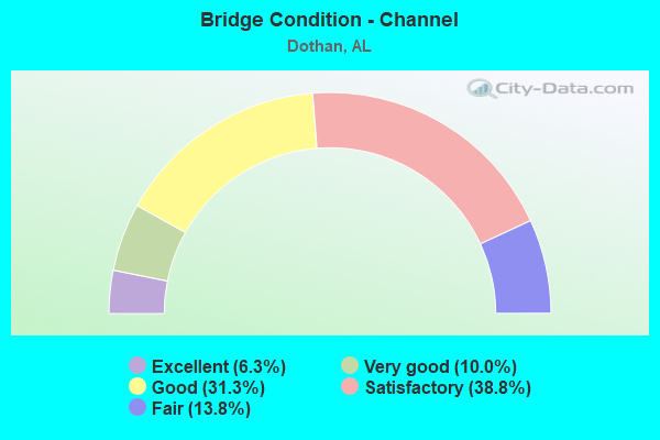
- Bridge Condition - Channel
- 6.3%Excellent
- 10.0%Very good
- 31.3%Good
- 38.8%Satisfactory
- 13.8%Fair
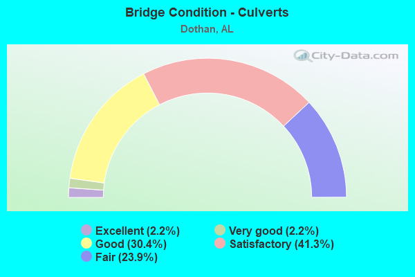
- Bridge Condition - Culverts
- 2.2%Excellent
- 2.2%Very good
- 30.4%Good
- 41.3%Satisfactory
- 23.9%Fair
Find on map >> Show street view
Structure Number: 1998, Location: DOTHAN (Lat: 31.245000, Lng: -85.420000), Route carried "on" structure: City street , Year Built: 2008, Status: Open, Structure Length: 0.72m (2.36ft), Average Daily Traffic: 640 (year 1999), Truck Traffic: 1%, Average Future Daily Traffic: 989 (year 2040), Design Load: HS 20, Features Intersected: STREAM, Facility Carried by Structure: N. ENGLEWOOD AVE.
Minimum Vertical Clearance: 30+ m (98+ ft), Kilometerpoint: 1.009, Lanes on structure: 2, Owner: City or Municipal Highway Agency, Approaching Roadway Width: 8.5m (27.9ft), Skew: 3 degrees, Material/Design: Concrete, Design/Construction: Culvert, Number Of Spans In Main Unit: 2, Length of Maximum Span: 3.0m (9.8ft), Curb or Sidewalk Widths: Left: 0.2m (0.7ft), Right: 0.2m (0.7ft), Curb-To-Curb Width: 8.2m (26.9ft), Out-to-Out Width: 10.6m (34.8ft)
Condition: Channel: Very good, Culverts: Very good, Operating Rating: 88.9 metric tons, Method Used To Determine Operating Rating: Load Factor (LF), Inventory Rating: 66.3 metric tons, Method Used To Determine Inventory Rating: Load Factor (LF), Structural Evaluation: Equal to present desirable criteria, Deck Geometry: Somewhat better than minimum adequacy, Waterway Adequacy: Equal to present desirable criteria, Approach Roadway Alignment: Equal to present minimum criteria, Length Of Structure Improvement: 1.35m (4.43ft), Designated Inspection Frequency: Every 24 months, Inspection Date: April 2020, Bridge Improvement Cost: $305,000, Roadway Improvement Cost: $31,000, Total Project Cost: $336,000 ( Estimate for 2022), Deck Structure Type: Concrete Cast-file-Place, Wearing Surface/Protective System: Wearing Surface: Bituminous
Find on map >> Show street view
Structure Number: 19981, Location: DOTHAN (Lat: 31.220900, Lng: -85.409000), Route carried "on" structure: City street , Year Built: 2007, Status: Open, Structure Length: 0.73m (2.40ft), Average Daily Traffic: 9,030 (year 1999), Average Future Daily Traffic: 9,500 (year 2040), Design Load: HS 20, Features Intersected: FOLKES BRANCH, Facility Carried by Structure: SOUTH PARK AVENUE
Minimum Vertical Clearance: 30+ m (98+ ft), Kilometerpoint: 1.780, Lanes on structure: 2, Owner: City or Municipal Highway Agency, Approaching Roadway Width: 9.1m (29.9ft), Skew: 3 degrees, Material/Design: Concrete, Design/Construction: Culvert, Number Of Spans In Main Unit: 2, Length of Maximum Span: 3.5m (11.5ft), Curb or Sidewalk Widths: Left: 0.6m (2.0ft), Right: 0.6m (2.0ft), Curb-To-Curb Width: 9.3m (30.5ft), Out-to-Out Width: 12.5m (41.0ft)
Condition: Channel: Very good, Culverts: Good, Operating Rating: 55.3 metric tons, Method Used To Determine Operating Rating: Load Factor (LF), Inventory Rating: 33.2 metric tons, Method Used To Determine Inventory Rating: Load Factor (LF), Structural Evaluation: Better than present minimum criteria, Deck Geometry: High priority of corrective action, Waterway Adequacy: Equal to present desirable criteria, Approach Roadway Alignment: Equal to present minimum criteria, Length Of Structure Improvement: 1.37m (4.49ft), Designated Inspection Frequency: Every 24 months, Inspection Date: March 2020, Bridge Improvement Cost: $378,000, Roadway Improvement Cost: $38,000, Total Project Cost: $416,000 ( Estimate for 2022), Deck Structure Type: Concrete Cast-file-Place, Wearing Surface/Protective System: Wearing Surface: Bituminous
Find on map >> Show street view
Structure Number: 20003, Location: .25 MI.S FLOWERS CHPL RD (Lat: 31.217533, Lng: -85.486539), Route carried "on" structure: State highway 605, Year Built: 2008, Status: Open, Structure Length: 6.22m (20.41ft), Average Daily Traffic: 10,260 (year 2013), Truck Traffic: 3%, Average Future Daily Traffic: 12,519 (year 2033), Design Load: HS 20, Features Intersected: BEAVER CREEK
Minimum Vertical Clearance: 30+ m (98+ ft), Kilometerpoint: 27.005, Lanes on structure: 2, Owner: State Highway Agency, Approaching Roadway Width: 19.5m (64.0ft), Material/Design: Prestressed concrete, Design/Construction: Stringer/Multi-beam, Number Of Spans In Main Unit: 6, Length of Maximum Span: 10.4m (34.1ft), Curb-To-Curb Width: 19.5m (64.0ft), Out-to-Out Width: 20.3m (66.6ft)
Condition: Deck: Excellent, Superstructure: Excellent, Substructure: Excellent, Channel: Good, Operating Rating: 71.3 metric tons, Method Used To Determine Operating Rating: Load Factor (LF), Inventory Rating: 42.7 metric tons, Method Used To Determine Inventory Rating: Load Factor (LF), Structural Evaluation: Superior to present desirable criteria, Deck Geometry: Superior to present desirable criteria, Waterway Adequacy: Equal to present minimum criteria, Approach Roadway Alignment: Equal to present desirable criteria, Length Of Structure Improvement: 7.26m (23.82ft), Designated Inspection Frequency: Every 24 months, Inspection Date: December 2021, Bridge Improvement Cost: $3,284,000, Roadway Improvement Cost: $328,000, Total Project Cost: $3,612,000 ( Estimate for 2022), Deck Structure Type: Concrete Cast-file-Place
Find on map >> Show street view
Structure Number: 20209, Location: DOTHAN (Lat: 31.250000, Lng: -85.433333), Route carried "on" structure: City street , Year Built: 2009, Status: Open, Structure Length: 3.11m (10.20ft), Average Daily Traffic: 13,813 (year 2010), Truck Traffic: 20%, Average Future Daily Traffic: 21,272 (year 2040), Design Load: HS 20, Features Intersected: LITTLE CHOCTAWHATCHEE, Facility Carried by Structure: DENTON RD
Minimum Vertical Clearance: 30+ m (98+ ft), Kilometerpoint: 3.309, Lanes on structure: 2, Owner: City or Municipal Highway Agency, Approaching Roadway Width: 9.1m (29.9ft), Material/Design: Concrete, Design/Construction: Channel Beam, Number Of Spans In Main Unit: 3, Length of Maximum Span: 10.4m (34.1ft), Curb-To-Curb Width: 11.1m (36.4ft), Out-to-Out Width: 11.5m (37.7ft)
Condition: Deck: Excellent, Superstructure: Excellent, Substructure: Excellent, Channel: Excellent, Operating Rating: 71.8 metric tons, Method Used To Determine Operating Rating: Load Factor (LF), Inventory Rating: 43.1 metric tons, Method Used To Determine Inventory Rating: Load Factor (LF), Structural Evaluation: Superior to present desirable criteria, Deck Geometry: Meets minimum limits, Waterway Adequacy: Superior to present desirable criteria, Approach Roadway Alignment: Superior to present desirable criteria, Length Of Structure Improvement: 3.96m (12.99ft), Designated Inspection Frequency: Every 24 months, Inspection Date: March 2020, Bridge Improvement Cost: $1,005,000, Roadway Improvement Cost: $101,000, Total Project Cost: $1,106,000 ( Estimate for 2022), Deck Structure Type: Concrete Precast Panels
Find on map >> Show street view
Structure Number: 20224, Location: CIRCLE TO PILGRAM REST CH (Lat: 31.211400, Lng: -85.431200), Route carried "on" structure: County highway 40, Year Built: 2010, Status: Open, Structure Length: 1.38m (4.53ft), Average Daily Traffic: 1,150 (year 2003), Truck Traffic: 5%, Average Future Daily Traffic: 1,799 (year 2040), Design Load: HS 20, Features Intersected: BEAVER CREEK, Facility Carried by Structure: FORTNER SREET
Minimum Vertical Clearance: 30+ m (98+ ft), Kilometerpoint: 0.966, Lanes on structure: 3, Owner: City or Municipal Highway Agency, Approaching Roadway Width: 11.0m (36.1ft), Material/Design: Concrete, Design/Construction: Culvert, Number Of Spans In Main Unit: 3, Length of Maximum Span: 4.3m (14.1ft), Curb-To-Curb Width: 11.0m (36.1ft), Out-to-Out Width: 23.8m (78.1ft)
Condition: Channel: Very good, Culverts: Excellent, Operating Rating: 50.6 metric tons, Method Used To Determine Operating Rating: Load Factor (LF), Inventory Rating: 30.4 metric tons, Method Used To Determine Inventory Rating: Load Factor (LF), Structural Evaluation: Better than present minimum criteria, Deck Geometry: High priority of replacement, Waterway Adequacy: Superior to present desirable criteria, Approach Roadway Alignment: Superior to present desirable criteria, Length Of Structure Improvement: 2.06m (6.76ft), Designated Inspection Frequency: Every 24 months, Inspection Date: September 2020, Bridge Improvement Cost: $928,000, Roadway Improvement Cost: $93,000, Total Project Cost: $1,021,000 ( Estimate for 2022), Deck Structure Type: Concrete Cast-file-Place, Wearing Surface/Protective System: Wearing Surface: Bituminous
Find on map >> Show street view
Structure Number: 2026, Location: US 231 S TO CO RD 203 (Lat: 31.159514, Lng: -85.405450), Route carried "on" structure: County highway , Year Built: 1960, Status: Open, Structure Length: 0.75m (2.46ft), Average Daily Traffic: 1,654 (year 2009), Truck Traffic: 3%, Average Future Daily Traffic: 2,557 (year 2033), Design Load: HS 20, Features Intersected: SAUNDERS BRANCH, Facility Carried by Structure: W. SAUNDERS RD.
Minimum Vertical Clearance: 0.00m, Kilometerpoint: 0.000, Lanes on structure: 2, Owner: County Highway Agency, Approaching Roadway Width: 6.7m (22.0ft), Material/Design: Concrete, Design/Construction: Culvert, Number Of Spans In Main Unit: 2, Length of Maximum Span: 3.7m (12.1ft)
Condition: Channel: Satisfactory, Culverts: Good, Operating Rating: 52.5 metric tons, Method Used To Determine Operating Rating: Load Factor (LF), Inventory Rating: 31.5 metric tons, Method Used To Determine Inventory Rating: Load Factor (LF), Structural Evaluation: Better than present minimum criteria, Waterway Adequacy: Better than present minimum criteria, Approach Roadway Alignment: Better than present minimum criteria, Length Of Structure Improvement: 1.39m (4.56ft), Designated Inspection Frequency: Every 24 months, Inspection Date: May 2021, Bridge Improvement Cost: $273,000, Roadway Improvement Cost: $27,000, Total Project Cost: $300,000 ( Estimate for 2022), Deck Structure Type: Concrete Cast-file-Place
Find on map >> Show street view
Structure Number: 20261, Location: CO.RD.59 TO CAMPBELLTONH (Lat: 31.185375, Lng: -85.418642), Route carried "on" structure: County highway , Year Built: 1958, Status: Open, Structure Length: 0.62m (2.03ft), Average Daily Traffic: 5,418 (year 2009), Truck Traffic: 17%, Average Future Daily Traffic: 9,026 (year 2033), Design Load: HS 20, Features Intersected: LIMESTONE CREEK, Facility Carried by Structure: TAYLOR RD.
Minimum Vertical Clearance: 0.00m, Kilometerpoint: 0.000, Lanes on structure: 2, Owner: County Highway Agency, Approaching Roadway Width: 7.0m (23.0ft), Material/Design: Concrete, Design/Construction: Culvert, Number Of Spans In Main Unit: 2, Length of Maximum Span: 3.0m (9.8ft)
Condition: Channel: Good, Culverts: Fair, Operating Rating: 39.9 metric tons, Method Used To Determine Operating Rating: Load Factor (LF), Inventory Rating: 23.9 metric tons, Method Used To Determine Inventory Rating: Load Factor (LF), Structural Evaluation: Somewhat better than minimum adequacy, Waterway Adequacy: Better than present minimum criteria, Approach Roadway Alignment: Better than present minimum criteria, Length Of Structure Improvement: 1.24m (4.07ft), Designated Inspection Frequency: Every 24 months, Inspection Date: May 2021, Bridge Improvement Cost: $215,000, Roadway Improvement Cost: $22,000, Total Project Cost: $237,000 ( Estimate for 2022), Deck Structure Type: Concrete Cast-file-Place
Find on map >> Show street view
Structure Number: 20493, Location: 6 MILE SOUTH DOTHAN CIRCL (Lat: 31.119467, Lng: -85.328450), Route carried "on" structure: State highway 53, Year Built: 1940, Status: Open, Structure Length: 0.63m (2.07ft), Average Daily Traffic: 3,550 (year 2013), Truck Traffic: 8%, Average Future Daily Traffic: 4,615 (year 2033), Design Load: HS 20, Features Intersected: BUCK CREEK
Minimum Vertical Clearance: 30+ m (98+ ft), Kilometerpoint: 20.059, Lanes on structure: 2, Owner: State Highway Agency, Approaching Roadway Width: 11.0m (36.1ft), Material/Design: Concrete, Design/Construction: Culvert, Number Of Spans In Main Unit: 2, Length of Maximum Span: 3.0m (9.8ft)
Condition: Channel: Satisfactory, Culverts: Satisfactory, Operating Rating: 43.3 metric tons, Method Used To Determine Operating Rating: Load Factor (LF), Inventory Rating: 25.9 metric tons, Method Used To Determine Inventory Rating: Load Factor (LF), Structural Evaluation: Equal to present minimum criteria, Waterway Adequacy: Equal to present desirable criteria, Approach Roadway Alignment: Equal to present desirable criteria, Length Of Structure Improvement: 1.25m (4.10ft), Designated Inspection Frequency: Every 24 months, Inspection Date: May 2020, Bridge Improvement Cost: $375,000, Roadway Improvement Cost: $38,000, Total Project Cost: $413,000 ( Estimate for 2022)
Find on map >> Show street view
Structure Number: 20825, Location: Denton rd (Lat: 31.261944, Lng: -85.411944), Route carried "on" structure: City street , Year Built: 2017, Status: Open, Structure Length: 2.44m (8.01ft), Average Daily Traffic: 10,457 (year 2015), Truck Traffic: 5%, Average Future Daily Traffic: 15,538 (year 2041), Design Load: HS 20, Features Intersected: Rock creek, Facility Carried by Structure: Denton rd
Minimum Vertical Clearance: 0.00m, Kilometerpoint: 1.619, Lanes on structure: 4, Owner: City or Municipal Highway Agency, Approaching Roadway Width: 19.2m (63.0ft), Material/Design: Prestressed concrete, Design/Construction: Stringer/Multi-beam, Number Of Spans In Main Unit: 2, Length of Maximum Span: 12.2m (40.0ft), Curb or Sidewalk Widths: Left: 2.1m (6.9ft), Right: 2.1m (6.9ft), Curb-To-Curb Width: 19.2m (63.0ft), Out-to-Out Width: 19.2m (63.0ft)
Condition: Deck: Excellent, Superstructure: Excellent, Substructure: Excellent, Channel: Excellent, Operating Rating: 63.0 metric tons, Method Used To Determine Operating Rating: Load Factor (LF), Inventory Rating: 37.6 metric tons, Method Used To Determine Inventory Rating: Load Factor (LF), Structural Evaluation: Superior to present desirable criteria, Deck Geometry: High priority of corrective action, Waterway Adequacy: Better than present minimum criteria, Approach Roadway Alignment: Better than present minimum criteria, Length Of Structure Improvement: 3.31m (10.86ft), Designated Inspection Frequency: Every 24 months, Inspection Date: March 2021, Bridge Improvement Cost: $1,428,000, Roadway Improvement Cost: $143,000, Total Project Cost: $1,571,000 ( Estimate for 2022), Deck Structure Type: Concrete Cast-file-Place, Wearing Surface/Protective System: Wearing Surface: Integral Concrete
Find on map >> Show street view
Structure Number: 20976, Location: CITY OF DOTHAN (Lat: 31.258100, Lng: -85.449200), Route carried "on" structure: City street , Year Built: 2019, Status: Open, Structure Length: 2.19m (7.19ft), Average Daily Traffic: 700 (year 2003), Truck Traffic: 1%, Average Future Daily Traffic: 1,140 (year 2041), Design Load: HS 20, Features Intersected: QUAIL CREEK, Facility Carried by Structure: BROOKSIDE DRIVE
Minimum Vertical Clearance: 30+ m (98+ ft), Kilometerpoint: 0.520, Lanes on structure: 2, Owner: City or Municipal Highway Agency, Approaching Roadway Width: 11.0m (36.1ft), Material/Design: Concrete, Design/Construction: Channel Beam, Number Of Spans In Main Unit: 3, Length of Maximum Span: 7.3m (24.0ft), Curb-To-Curb Width: 11.6m (38.1ft), Out-to-Out Width: 12.3m (40.4ft)
Condition: Deck: Excellent, Superstructure: Excellent, Substructure: Excellent, Channel: Excellent, Operating Rating: 57.0 metric tons, Method Used To Determine Operating Rating: Load Factor (LF), Inventory Rating: 34.1 metric tons, Method Used To Determine Inventory Rating: Load Factor (LF), Structural Evaluation: Superior to present desirable criteria, Deck Geometry: High priority of corrective action, Approach Roadway Alignment: Somewhat better than minimum adequacy, Length Of Structure Improvement: 3.00m (9.84ft), Designated Inspection Frequency: Every 24 months, Inspection Date: August 2021, Bridge Improvement Cost: $822,000, Roadway Improvement Cost: $82,000, Total Project Cost: $904,000 ( Estimate for 2022), Deck Structure Type: Concrete Precast Panels, Wearing Surface/Protective System: Wearing Surface: Monolithic Concrete
Find on map >> Show street view
Structure Number: 21505, Location: _ (Lat: 31.264114, Lng: -85.543867), Route carried "on" structure: County highway 560, Year Built: 2019, Status: Open, Structure Length: 3.29m (10.79ft), Average Daily Traffic: 289 (year 2018), Average Future Daily Traffic: 352 (year 2028), Design Load: HS 20, Features Intersected: DEAN CREEK
Minimum Vertical Clearance: 2.68m (8.79ft), Kilometerpoint: 0.000, Lanes on structure: 2, Owner: County Highway Agency, Approaching Roadway Width: 7.3m (24.0ft), Skew: 9 degrees, Material/Design: Concrete, Design/Construction: Channel Beam, Number Of Spans In Main Unit: 3, Length of Maximum Span: 12.2m (40.0ft), Curb-To-Curb Width: 7.3m (24.0ft), Out-to-Out Width: 8.7m (28.5ft)
Condition: Deck: Excellent, Superstructure: Excellent, Substructure: Excellent, Channel: Excellent, Operating Rating: 56.6 metric tons, Method Used To Determine Operating Rating: Load Factor (LF), Inventory Rating: 33.9 metric tons, Method Used To Determine Inventory Rating: Load Factor (LF), Structural Evaluation: Superior to present desirable criteria, Deck Geometry: Somewhat better than minimum adequacy, Waterway Adequacy: Better than present minimum criteria, Approach Roadway Alignment: Superior to present desirable criteria, Length Of Structure Improvement: 4.17m (13.68ft), Designated Inspection Frequency: Every 24 months, Inspection Date: May 2021, Bridge Improvement Cost: $800,000, Roadway Improvement Cost: $80,000, Total Project Cost: $880,000 ( Estimate for 2022), Deck Structure Type: Concrete Precast Panels
Find on map >> Show street view
Structure Number: 6411, Location: JCT. OF ALA.52 E (Lat: 31.222519, Lng: -85.360553), Route carried "under" structure: State highway 52, Year Built: 1958, Structure Length: 0. m, Average Daily Traffic: 7,350 (year 2013), Truck Traffic: 8%, Features Intersected: SR 52,C. OF GA. R.R., Facility Carried by Structure: SR 210 MP 9.990
Minimum Vertical Clearance: 5.49m (18.01ft), Kilometerpoint: 106.259, Lanes on structure: 3, Lanes under structure: 2, Material/Design: Concrete continuous, Design/Construction: Tee Beam, Length of Maximum Span: 18.9m (62.0ft)
Find on map >> Show street view
Structure Number: 6412, Location: JCT. SR. 52 E. (Lat: 31.222508, Lng: -85.360381), Route carried "under" structure: State highway 52, Year Built: 1958, Structure Length: 0. m, Average Daily Traffic: 7,350 (year 2013), Truck Traffic: 8%, Features Intersected: SR 52,C. OF GA. R.R., Facility Carried by Structure: SR 210 MP 9.990
Minimum Vertical Clearance: 5.49m (18.01ft), Kilometerpoint: 106.259, Lanes on structure: 2, Lanes under structure: 2, Material/Design: Concrete continuous, Design/Construction: Tee Beam, Length of Maximum Span: 18.9m (62.0ft)
Find on map >> Show street view
Structure Number: 11197, Location: 0.5 MI.E. U.S. 231 (Lat: 31.223067, Lng: -85.383550), Route carried "under" structure: Business City street , Year Built: 1974, Structure Length: 0. m, Average Daily Traffic: 460 (year 2013), Truck Traffic: 1%, Features Intersected: RANGE ST C/GA * BAYL R R, Facility Carried by Structure: US 84 MP 210.502
Minimum Vertical Clearance: 7.06m (23.16ft), Kilometerpoint: 339.770, Lanes on structure: 3, Lanes under structure: 2, Material/Design: Steel, Design/Construction: Stringer/Multi-beam, Length of Maximum Span: 24.7m (81.0ft)
Find on map >> Show street view
Structure Number: 11198, Location: 0.5 MI E. US 231 (Lat: 31.223033, Lng: -85.383053), Route carried "under" structure: Business City street , Year Built: 1974, Structure Length: 0. m, Average Daily Traffic: 460 (year 2013), Truck Traffic: 1%, Features Intersected: RANGE ST C/GA * BAYL R R, Facility Carried by Structure: US 84 MP 210.502
Minimum Vertical Clearance: 7.06m (23.16ft), Kilometerpoint: 3338.771, Lanes on structure: 3, Lanes under structure: 2, Material/Design: Steel, Design/Construction: Stringer/Multi-beam, Length of Maximum Span: 25.9m (85.0ft)