Bridge Statistics for East Brunswick, New Jersey (NJ)
Condition, Traffic, Stress, Structural Evaluation, Project Costs
- National Bridge Inventory (NBI) Statistics
- 59Number of bridges
- 787ft / 240mTotal length
- $19,342,000Total costs
- 2,211,995Total average daily traffic
- 259,942Total average daily truck traffic
- National Bridge Inventory (NBI) Registered Bridges for East Brunswick
- No street view available for this location
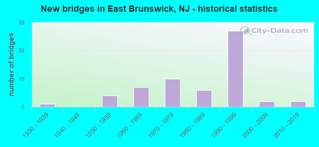
- New bridges - historical statistics
- 11930-1939
- 41950-1959
- 71960-1969
- 101970-1979
- 61980-1989
- 271990-1999
- 22000-2009
- 22010-2019
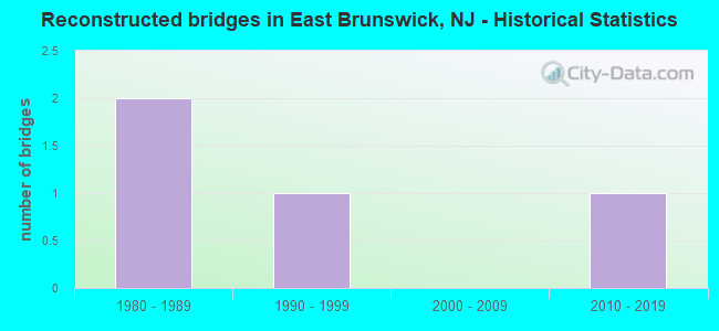
- Reconstructed bridges - Historical Statistics
- 21980-1989
- 11990-1999
- 02000-2009
- 12010-2019
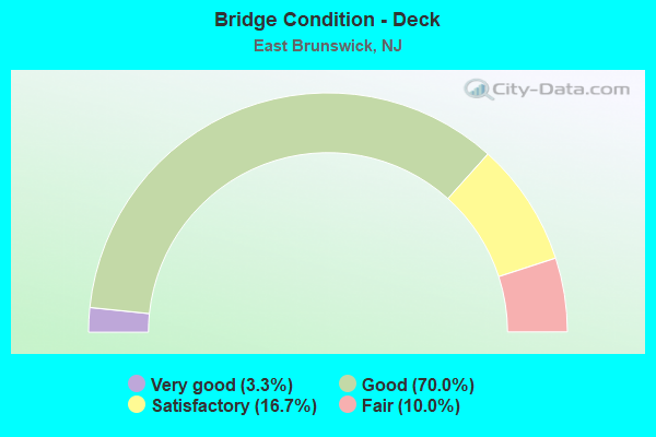
- Bridge Condition - Deck
- 3.3%Very good
- 70.0%Good
- 16.7%Satisfactory
- 10.0%Fair
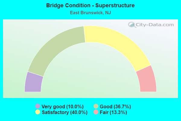
- Bridge Condition - Superstructure
- 10.0%Very good
- 36.7%Good
- 40.0%Satisfactory
- 13.3%Fair
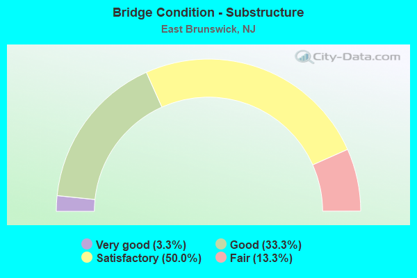
- Bridge Condition - Substructure
- 3.3%Very good
- 33.3%Good
- 50.0%Satisfactory
- 13.3%Fair
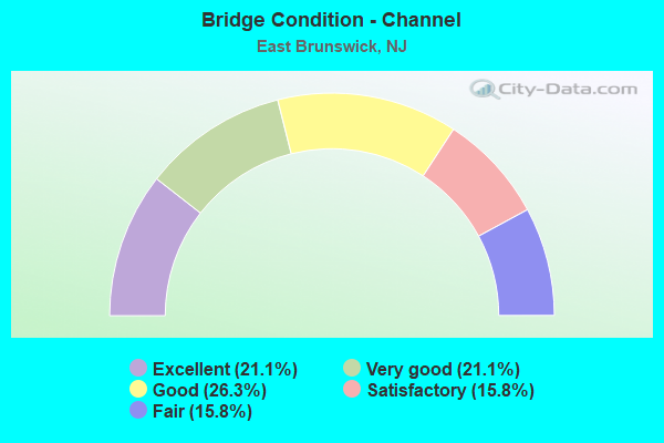
- Bridge Condition - Channel
- 21.1%Excellent
- 21.1%Very good
- 26.3%Good
- 15.8%Satisfactory
- 15.8%Fair
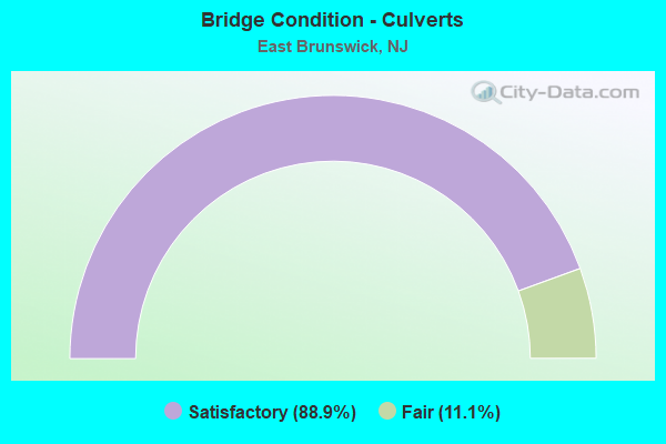
- Bridge Condition - Culverts
- 88.9%Satisfactory
- 11.1%Fair
Find on map >> Show street view
Structure Number: 1212151, Location: 2.5 MILES SOUTH OF NJ TPK (Lat: 40.439581, Lng: -74.393689), Route carried "on" structure: County highway 535, Year Built: 1963, Status: Open, Structure Length: 5.00m (16.40ft), Average Daily Traffic: 22,596 (year 2020), Truck Traffic: 4%, Average Future Daily Traffic: 27,600 (year 2040), Design Load: HS 20+Mod, Features Intersected: NEW JERSEY ROUTE 18
Minimum Vertical Clearance: 30.45m (99.90ft), Kilometerpoint: 41.392, Lanes on structure: 2, Lanes under structure: 8, Base Highway Network: Yes, Owner: State Highway Agency, Approaching Roadway Width: 14.9m (48.9ft), Skew: 20 degrees, Material/Design: Steel, Design/Construction: Stringer/Multi-beam, Number Of Spans In Main Unit: 2, Length of Maximum Span: 23.8m (78.1ft), Curb or Sidewalk Widths: Left: 1.5m (4.9ft), Right: 0.5m (1.6ft), Curb-To-Curb Width: 14.9m (48.9ft), Out-to-Out Width: 19.1m (62.7ft)
Condition: Deck: Fair, Superstructure: Fair, Substructure: Satisfactory, Operating Rating: 65.3 metric tons, Method Used To Determine Operating Rating: Load Factor (LF), Inventory Rating: 39.0 metric tons, Method Used To Determine Inventory Rating: Load Factor (LF), Structural Evaluation: Somewhat better than minimum adequacy, Deck Geometry: Superior to present desirable criteria, Underclear: Somewhat better than minimum adequacy, Approach Roadway Alignment: Equal to present minimum criteria, Designated Inspection Frequency: Every 24 months, Inspection Date: May 2020, Deck Structure Type: Concrete Cast-file-Place, Wearing Surface/Protective System: Wearing Surface: Monolithic Concrete
Find on map >> Show street view
Structure Number: 1212152, Location: .2 MILES NORTH OF 535 JCT (Lat: 40.442239, Lng: -74.394861), Route carried "on" structure: County highway 606, Year Built: 1963, Status: Open, Structure Length: 4.97m (16.31ft), Average Daily Traffic: 15,846 (year 2021), Truck Traffic: 4%, Average Future Daily Traffic: 19,015 (year 2041), Design Load: HS 20, Features Intersected: ROUTE NJ 18, Facility Carried by Structure: MILLTOWN ROAD
Minimum Vertical Clearance: 30+ m (98+ ft), Kilometerpoint: 0.451, Lanes on structure: 2, Lanes under structure: 8, Owner: State Highway Agency, Approaching Roadway Width: 17.1m (56.1ft), Skew: 20 degrees, Material/Design: Steel, Design/Construction: Stringer/Multi-beam, Number Of Spans In Main Unit: 2, Length of Maximum Span: 23.8m (78.1ft), Curb or Sidewalk Widths: Left: 0.5m (1.6ft), Right: 1.8m (5.9ft), Curb-To-Curb Width: 15.8m (51.8ft), Out-to-Out Width: 20.0m (65.6ft)
Condition: Deck: Fair, Superstructure: Fair, Substructure: Satisfactory, Inventory Rating: 54.4 metric tons, Method Used To Determine Inventory Rating: Load Factor (LF), Structural Evaluation: Somewhat better than minimum adequacy, Deck Geometry: Superior to present desirable criteria, Underclear: Somewhat better than minimum adequacy, Approach Roadway Alignment: Better than present minimum criteria, Designated Inspection Frequency: Every 24 months, Inspection Date: March 2021, Deck Structure Type: Concrete Cast-file-Place, Wearing Surface/Protective System: Wearing Surface: Monolithic Concrete
Find on map >> Show street view
Structure Number: 1212153, Location: 2.0 MI S OF NJTPK JCT (Lat: 40.443911, Lng: -74.395011), Route carried "on" structure: State highway 18, Year Built: 1931, Status: Open, Structure Length: 3.41m (11.19ft), Average Daily Traffic: 33,900 (year 2020), Truck Traffic: 4%, Average Future Daily Traffic: 40,680 (year 2040), Features Intersected: CONRAIL
Minimum Vertical Clearance: 30+ m (98+ ft), Kilometerpoint: 60.286, Lanes on structure: 4, Base Highway Network: Yes, Owner: State Highway Agency, Approaching Roadway Width: 15.2m (49.9ft), Skew: 1 degrees, Material/Design: Steel, Design/Construction: Stringer/Multi-beam, Number Of Spans In Main Unit: 3, Length of Maximum Span: 11.0m (36.1ft), Curb or Sidewalk Widths: Left: 1.8m (5.9ft), Right: 1.8m (5.9ft), Curb-To-Curb Width: 15.2m (49.9ft), Out-to-Out Width: 19.6m (64.3ft)
Condition: Deck: Fair, Superstructure: Fair, Substructure: Fair, Operating Rating: 87.1 metric tons, Method Used To Determine Operating Rating: Load Factor (LF), Inventory Rating: 51.7 metric tons, Method Used To Determine Inventory Rating: Load Factor (LF), Structural Evaluation: Somewhat better than minimum adequacy, Deck Geometry: High priority of corrective action, Underclear: Meets minimum limits, Approach Roadway Alignment: Equal to present desirable criteria, Designated Inspection Frequency: Every 24 months, Inspection Date: August 2020, Deck Structure Type: Concrete Cast-file-Place, Wearing Surface/Protective System: Wearing Surface: Bituminous
Find on map >> Show street view
Structure Number: 1212154, Location: 2.12 MI S OF NJTPK JCT (Lat: 40.444239, Lng: -74.395469), Route carried "on" structure: State highway 18, Year Built: 1963, Status: Open, Structure Length: 3.54m (11.61ft), Average Daily Traffic: 32,660 (year 2020), Truck Traffic: 4%, Average Future Daily Traffic: 39,192 (year 2040), Design Load: HS 20, Features Intersected: CONRAIL
Minimum Vertical Clearance: 30+ m (98+ ft), Kilometerpoint: 60.286, Lanes on structure: 3, Base Highway Network: Yes, Owner: State Highway Agency, Approaching Roadway Width: 12.2m (40.0ft), Skew: 1 degrees, Material/Design: Prestressed concrete, Design/Construction: Box Beam or Girders - Multiple, Number Of Spans In Main Unit: 3, Length of Maximum Span: 11.6m (38.1ft), Curb or Sidewalk Widths: Left: 1.8m (5.9ft), Right: 0.5m (1.6ft), Curb-To-Curb Width: 12.2m (40.0ft), Out-to-Out Width: 15.1m (49.5ft)
Condition: Deck: Satisfactory, Superstructure: Satisfactory, Substructure: Satisfactory, Operating Rating: 76.2 metric tons, Method Used To Determine Operating Rating: Load Factor (LF), Inventory Rating: 45.4 metric tons, Method Used To Determine Inventory Rating: Load Factor (LF), Structural Evaluation: Equal to present minimum criteria, Deck Geometry: Meets minimum limits, Underclear: Meets minimum limits, Approach Roadway Alignment: Equal to present desirable criteria, Designated Inspection Frequency: Every 24 months, Inspection Date: August 2020, Deck Structure Type: Concrete Cast-file-Place, Wearing Surface/Protective System: Wearing Surface: Bituminous
Find on map >> Show street view
Structure Number: 123B078, Location: 0.06 miles north of CR677 (Lat: 40.416481, Lng: -74.361700), Route carried "on" structure: County highway 615, Year Built: 2008, Status: Open, Structure Length: 3.84m (12.60ft), Average Daily Traffic: 10,989 (year 2021), Truck Traffic: 4%, Average Future Daily Traffic: 13,409 (year 2041), Design Load: HS 25 or greater, Features Intersected: SOUTH RIVER, Facility Carried by Structure: BORDENTOWN AVENUE
Minimum Vertical Clearance: 30+ m (98+ ft), Kilometerpoint: 28.019, Lanes on structure: 2, Owner: County Highway Agency, Approaching Roadway Width: 12.2m (40.0ft), Material/Design: Prestressed concrete, Design/Construction: Box Beam or Girders - Multiple, Number Of Spans In Main Unit: 2, Length of Maximum Span: 18.3m (60.0ft), Curb or Sidewalk Widths: Left: 1.5m (4.9ft), Right: 0.2m (0.7ft), Curb-To-Curb Width: 12.2m (40.0ft), Out-to-Out Width: 14.6m (47.9ft)
Condition: Deck: Satisfactory, Superstructure: Good, Substructure: Good, Channel: Satisfactory, Inventory Rating: 73.5 metric tons, Method Used To Determine Inventory Rating: Load Factor (LF), Structural Evaluation: Better than present minimum criteria, Deck Geometry: Somewhat better than minimum adequacy, Waterway Adequacy: Equal to present desirable criteria, Approach Roadway Alignment: Equal to present desirable criteria, Designated Inspection Frequency: Every 24 months, Underwater Inspection Frequency: Every 48 months, Inspection Date: June 2021, Underwater Inspection Date: August 2019, Deck Structure Type: Concrete Cast-file-Place, Wearing Surface/Protective System: Wearing Surface: Monolithic Concrete, Deck Protection: Epoxy Coated Reinforcing
Find on map >> Show street view
Structure Number: 123B135, Location: 2.3 MI. E. OF NJ TURNPIKE (Lat: 40.408700, Lng: -74.430950), Route carried "on" structure: City street , Year Built: 1987, Year Reconstructed: 1998, Status: Open, Structure Length: 0.82m (2.69ft), Average Daily Traffic: 3,787 (year 2021), Truck Traffic: 3%, Average Future Daily Traffic: 4,621 (year 2041), Design Load: HS 20+Mod, Features Intersected: IRELAND BROOK, Facility Carried by Structure: FERN ROAD
Minimum Vertical Clearance: 30+ m (98+ ft), Kilometerpoint: 1.706, Lanes on structure: 2, Owner: County Highway Agency, Approaching Roadway Width: 11.6m (38.1ft), Material/Design: Concrete, Design/Construction: Culvert, Number Of Spans In Main Unit: 2, Length of Maximum Span: 4.9m (16.1ft), Curb or Sidewalk Widths: Left: 1.8m (5.9ft), Right: 1.7m (5.6ft), Curb-To-Curb Width: 12.4m (40.7ft), Out-to-Out Width: 16.6m (54.5ft)
Condition: Channel: Very good, Culverts: Satisfactory, Operating Rating: 68.0 metric tons, Method Used To Determine Operating Rating: Load Factor (LF), Inventory Rating: 40.8 metric tons, Method Used To Determine Inventory Rating: Load Factor (LF), Structural Evaluation: Equal to present minimum criteria, Deck Geometry: Equal to present minimum criteria, Waterway Adequacy: Superior to present desirable criteria, Approach Roadway Alignment: Equal to present desirable criteria, Designated Inspection Frequency: Every 24 months, Inspection Date: April 2021, Deck Structure Type: Concrete Cast-file-Place, Wearing Surface/Protective System: Wearing Surface: Monolithic Concrete
Find on map >> Show street view
Structure Number: 123B144, Location: 2.0 MI N OF ROUTE 130 (Lat: 40.429639, Lng: -74.468561), Route carried "on" structure: City street , Year Built: 1962, Status: Open, Structure Length: 0.70m (2.30ft), Average Daily Traffic: 3,630 (year 2019), Truck Traffic: 4%, Average Future Daily Traffic: 4,430 (year 2039), Features Intersected: BEAVERDAM BROOK, Facility Carried by Structure: RIVA AVENUE
Minimum Vertical Clearance: 30+ m (98+ ft), Kilometerpoint: 0.966, Lanes on structure: 2, Owner: County Highway Agency, Approaching Roadway Width: 9.1m (29.9ft), Material/Design: Concrete, Design/Construction: Culvert, Number Of Spans In Main Unit: 2, Length of Maximum Span: 3.4m (11.2ft), Curb-To-Curb Width: 9.1m (29.9ft), Out-to-Out Width: 9.8m (32.2ft)
Condition: Channel: Very good, Culverts: Satisfactory, Operating Rating: 54.4 metric tons, Method Used To Determine Operating Rating: Field evaluation and documented engineering judgment, Inventory Rating: 32.7 metric tons, Method Used To Determine Inventory Rating: Field evaluation and documented engineering judgment, Structural Evaluation: Equal to present minimum criteria, Deck Geometry: Meets minimum limits, Waterway Adequacy: Somewhat better than minimum adequacy, Approach Roadway Alignment: Equal to present desirable criteria, Designated Inspection Frequency: Every 24 months, Inspection Date: March 2021, Deck Structure Type: Concrete Cast-file-Place, Wearing Surface/Protective System: Wearing Surface: Bituminous
Find on map >> Show street view
Structure Number: 123B152, Location: 1 MI S OF US 1 (Lat: 40.458431, Lng: -74.425119), Route carried "on" structure: County highway 617, Year Built: 2009, Status: Open, Structure Length: 1.86m (6.10ft), Average Daily Traffic: 26,025 (year 2021), Truck Traffic: 3%, Average Future Daily Traffic: 31,755 (year 2041), Design Load: HS 25 or greater, Features Intersected: SAWMILL BROOK
Minimum Vertical Clearance: 30+ m (98+ ft), Kilometerpoint: 8.771, Lanes on structure: 4, Base Highway Network: Yes, Owner: County Highway Agency, Approaching Roadway Width: 23.8m (78.1ft), Skew: 22 degrees, Material/Design: Prestressed concrete, Design/Construction: Box Beam or Girders - Multiple, Number Of Spans In Main Unit: 1, Length of Maximum Span: 17.1m (56.1ft), Curb or Sidewalk Widths: Left: 0.0m, Right: 2.7m (8.9ft), Curb-To-Curb Width: 23.8m (78.1ft), Out-to-Out Width: 27.4m (89.9ft)
Condition: Deck: Satisfactory, Superstructure: Good, Substructure: Good, Channel: Good, Operating Rating: 44.5 metric tons, Method Used To Determine Operating Rating: Load Factor (LF), Inventory Rating: 26.3 metric tons, Method Used To Determine Inventory Rating: Load Factor (LF), Structural Evaluation: Equal to present minimum criteria, Deck Geometry: Superior to present desirable criteria, Waterway Adequacy: Equal to present minimum criteria, Approach Roadway Alignment: Equal to present desirable criteria, Designated Inspection Frequency: Every 24 months, Inspection Date: April 2021, Deck Structure Type: Concrete Cast-file-Place, Wearing Surface/Protective System: Deck Protection: Epoxy Coated Reinforcing
Find on map >> Show street view
Structure Number: 123B156, Location: 0.6 MI WEST OF RT 18 (Lat: 40.453461, Lng: -74.414131), Route carried "on" structure: City street , Year Built: 1967, Status: Open, Structure Length: 1.19m (3.90ft), Average Daily Traffic: 14,595 (year 2021), Truck Traffic: 4%, Average Future Daily Traffic: 17,805 (year 2041), Features Intersected: TRIB. LAWRENCE BROOK, Facility Carried by Structure: TICES LANE
Minimum Vertical Clearance: 30+ m (98+ ft), Kilometerpoint: 2.221, Lanes on structure: 2, Owner: County Highway Agency, Approaching Roadway Width: 12.2m (40.0ft), Skew: 1 degrees, Material/Design: Concrete, Design/Construction: Culvert, Number Of Spans In Main Unit: 2, Length of Maximum Span: 5.8m (19.0ft), Curb or Sidewalk Widths: Left: 2.7m (8.9ft), Right: 0.0m, Curb-To-Curb Width: 12.2m (40.0ft), Out-to-Out Width: 21.8m (71.5ft)
Condition: Channel: Good, Culverts: Satisfactory, Operating Rating: 44.5 metric tons, Method Used To Determine Operating Rating: Field evaluation and documented engineering judgment, Inventory Rating: 32.7 metric tons, Method Used To Determine Inventory Rating: Field evaluation and documented engineering judgment, Structural Evaluation: Equal to present minimum criteria, Deck Geometry: Somewhat better than minimum adequacy, Waterway Adequacy: Better than present minimum criteria, Approach Roadway Alignment: Equal to present minimum criteria, Designated Inspection Frequency: Every 24 months, Inspection Date: June 2021
Find on map >> Show street view
Structure Number: 123B2, Location: 0.1 S. JCT RUES LANE (Lat: 40.416581, Lng: -74.413250), Route carried "on" structure: County highway 535, Year Built: 1981, Year Reconstructed: 1994, Status: Open, Structure Length: 1.19m (3.90ft), Average Daily Traffic: 5,805 (year 2021), Truck Traffic: 4%, Average Future Daily Traffic: 7,085 (year 2041), Design Load: HS 20, Features Intersected: IRELAND BROOK, Facility Carried by Structure: CRANBURY ROAD
Minimum Vertical Clearance: 30+ m (98+ ft), Kilometerpoint: 37.997, Lanes on structure: 4, Base Highway Network: Yes, Owner: County Highway Agency, Approaching Roadway Width: 21.3m (69.9ft), Skew: 25 degrees, Material/Design: Concrete, Design/Construction: Culvert, Number Of Spans In Main Unit: 2, Length of Maximum Span: 5.5m (18.0ft), Curb or Sidewalk Widths: Left: 1.5m (4.9ft), Right: 1.8m (5.9ft)
Condition: Channel: Good, Culverts: Satisfactory, Operating Rating: 54.4 metric tons, Method Used To Determine Operating Rating: Field evaluation and documented engineering judgment, Inventory Rating: 32.7 metric tons, Method Used To Determine Inventory Rating: Field evaluation and documented engineering judgment, Structural Evaluation: Equal to present minimum criteria, Waterway Adequacy: Better than present minimum criteria, Approach Roadway Alignment: Equal to present desirable criteria, Designated Inspection Frequency: Every 24 months, Inspection Date: March 2021
Find on map >> Show street view
Structure Number: 123B231, Location: 1.08 miles west of CR527 (Lat: 40.440719, Lng: -74.409319), Route carried "on" structure: County highway 606, Year Built: 1997, Status: Open, Structure Length: 0.76m (2.49ft), Average Daily Traffic: 15,847 (year 2021), Truck Traffic: 4%, Average Future Daily Traffic: 19,333 (year 2041), Features Intersected: SAWMILL BROOK, Facility Carried by Structure: MILLTOWN ROAD
Minimum Vertical Clearance: 30+ m (98+ ft), Kilometerpoint: 1.738, Lanes on structure: 2, Owner: County Highway Agency, Approaching Roadway Width: 10.4m (34.1ft), Skew: 3 degrees, Material/Design: Steel, Design/Construction: Culvert, Number Of Spans In Main Unit: 2, Length of Maximum Span: 3.7m (12.1ft), Curb or Sidewalk Widths: Left: 1.2m (3.9ft), Right: 0.0m
Condition: Channel: Fair, Culverts: Satisfactory, Operating Rating: 44.5 metric tons, Method Used To Determine Operating Rating: Field evaluation and documented engineering judgment, Inventory Rating: 32.7 metric tons, Method Used To Determine Inventory Rating: Field evaluation and documented engineering judgment, Structural Evaluation: Equal to present minimum criteria, Waterway Adequacy: Superior to present desirable criteria, Approach Roadway Alignment: Equal to present desirable criteria, Designated Inspection Frequency: Every 24 months, Inspection Date: June 2021
Find on map >> Show street view
Structure Number: 123B232, Location: 0.4 miles North of CR606 (Lat: 40.446719, Lng: -74.409350), Route carried "on" structure: City street , Year Built: 1990, Status: Open, Structure Length: 0.76m (2.49ft), Average Daily Traffic: 449 (year 2021), Truck Traffic: 1%, Average Future Daily Traffic: 548 (year 2041), Design Load: HS 20, Features Intersected: SAWMILL BROOK, Facility Carried by Structure: KIMBERLY ROAD
Minimum Vertical Clearance: 30+ m (98+ ft), Kilometerpoint: 0.000, Lanes on structure: 2, Owner: County Highway Agency, Approaching Roadway Width: 12.5m (41.0ft), Material/Design: Concrete, Design/Construction: Culvert, Number Of Spans In Main Unit: 2, Length of Maximum Span: 2.7m (8.9ft)
Condition: Channel: Fair, Culverts: Satisfactory, Operating Rating: 51.7 metric tons, Method Used To Determine Operating Rating: Load Factor (LF), Inventory Rating: 30.8 metric tons, Method Used To Determine Inventory Rating: Load Factor (LF), Structural Evaluation: Equal to present minimum criteria, Waterway Adequacy: Equal to present desirable criteria, Approach Roadway Alignment: Equal to present desirable criteria, Designated Inspection Frequency: Every 24 months, Underwater Inspection Frequency: Every 48 months, Inspection Date: June 2021, Underwater Inspection Date: June 2019
Find on map >> Show street view
Structure Number: 123B233, Location: 0.6 miles North of CR606 (Lat: 40.449939, Lng: -74.409239), Route carried "on" structure: City street , Year Built: 1998, Status: Open, Structure Length: 1.65m (5.41ft), Average Daily Traffic: 7 (year 2021), Truck Traffic: 1%, Average Future Daily Traffic: 9 (year 2041), Features Intersected: SAWMILL BROOK, Facility Carried by Structure: MILLBROOK COURT
Minimum Vertical Clearance: 30+ m (98+ ft), Kilometerpoint: 0.000, Lanes on structure: 2, Owner: County Highway Agency, Approaching Roadway Width: 9.1m (29.9ft), Material/Design: Prestressed concrete, Design/Construction: Box Beam or Girders - Multiple, Number Of Spans In Main Unit: 1, Length of Maximum Span: 15.2m (49.9ft), Curb-To-Curb Width: 9.2m (30.2ft), Out-to-Out Width: 9.8m (32.2ft)
Condition: Deck: Good, Superstructure: Very good, Substructure: Satisfactory, Channel: Fair, Operating Rating: 44.5 metric tons, Method Used To Determine Operating Rating: Field evaluation and documented engineering judgment, Inventory Rating: 32.7 metric tons, Method Used To Determine Inventory Rating: Field evaluation and documented engineering judgment, Structural Evaluation: Equal to present minimum criteria, Deck Geometry: Better than present minimum criteria, Waterway Adequacy: Superior to present desirable criteria, Approach Roadway Alignment: Equal to present desirable criteria, Designated Inspection Frequency: Every 24 months, Inspection Date: June 2021, Deck Structure Type: Concrete Cast-file-Place, Wearing Surface/Protective System: Wearing Surface: Monolithic Concrete, Deck Protection: Epoxy Coated Reinforcing
Find on map >> Show street view
Structure Number: 124B027, Location: 1.1 MI EAST OF US 130 (Lat: 40.424200, Lng: -74.477811), Route carried "on" structure: County highway 694, Year Built: 1986, Status: Open, Structure Length: 1.98m (6.50ft), Average Daily Traffic: 6,724 (year 2021), Truck Traffic: 4%, Average Future Daily Traffic: 8,203 (year 2041), Design Load: HS 20+Mod, Features Intersected: FARRINGTON LAKE
Minimum Vertical Clearance: 30+ m (98+ ft), Kilometerpoint: 1.287, Lanes on structure: 2, Owner: County Highway Agency, Approaching Roadway Width: 12.2m (40.0ft), Material/Design: Prestressed concrete, Design/Construction: Box Beam or Girders - Multiple, Number Of Spans In Main Unit: 1, Length of Maximum Span: 18.9m (62.0ft), Curb or Sidewalk Widths: Left: 1.5m (4.9ft), Right: 1.5m (4.9ft), Curb-To-Curb Width: 12.2m (40.0ft), Out-to-Out Width: 15.8m (51.8ft)
Condition: Deck: Good, Superstructure: Very good, Substructure: Good, Channel: Very good, Operating Rating: 70.8 metric tons, Method Used To Determine Operating Rating: Load Factor (LF), Inventory Rating: 42.6 metric tons, Method Used To Determine Inventory Rating: Load Factor (LF), Structural Evaluation: Better than present minimum criteria, Deck Geometry: Somewhat better than minimum adequacy, Waterway Adequacy: Equal to present desirable criteria, Approach Roadway Alignment: Equal to present minimum criteria, Designated Inspection Frequency: Every 24 months, Underwater Inspection Frequency: Every 48 months, Inspection Date: May 2021, Underwater Inspection Date: July 2019, Deck Structure Type: Concrete Cast-file-Place, Wearing Surface/Protective System: Wearing Surface: Monolithic Concrete, Deck Protection: Epoxy Coated Reinforcing
Find on map >> Show street view
Structure Number: 124B058, Location: 0.2 MILE EAST OF NJTPK (Lat: 40.406719, Lng: -74.446500), Route carried "on" structure: City street , Year Built: 1985, Status: Open, Structure Length: 0.61m (2.00ft), Average Daily Traffic: 4,070 (year 2021), Truck Traffic: 4%, Average Future Daily Traffic: 4,970 (year 2041), Design Load: HS 20+Mod, Features Intersected: IRELAND BROOK TRIBUTARY, Facility Carried by Structure: DUNHAMS CORNER RD.
Minimum Vertical Clearance: 30+ m (98+ ft), Kilometerpoint: 1.786, Lanes on structure: 2, Owner: County Highway Agency, Approaching Roadway Width: 7.9m (25.9ft), Material/Design: Concrete, Design/Construction: Culvert, Number Of Spans In Main Unit: 1, Length of Maximum Span: 6.1m (20.0ft), Curb or Sidewalk Widths: Left: 1.4m (4.6ft), Right: 1.4m (4.6ft), Curb-To-Curb Width: 11.9m (39.0ft), Out-to-Out Width: 15.5m (50.9ft)
Condition: Channel: Satisfactory, Culverts: Satisfactory, Operating Rating: 60.2 metric tons, Method Used To Determine Operating Rating: Load Factor (LF), Inventory Rating: 36.0 metric tons, Method Used To Determine Inventory Rating: Load Factor (LF), Structural Evaluation: Equal to present minimum criteria, Deck Geometry: Somewhat better than minimum adequacy, Waterway Adequacy: Better than present minimum criteria, Approach Roadway Alignment: Equal to present desirable criteria, Designated Inspection Frequency: Every 24 months, Inspection Date: March 2021, Deck Structure Type: Concrete Cast-file-Place, Wearing Surface/Protective System: Wearing Surface: Monolithic Concrete
Find on map >> Show street view
Structure Number: I08334C, Location: .05 MI N INTERCHANGE 9 (Lat: 40.478450, Lng: -74.410264), Route carried "on" structure: City street , Year Built: 1988, Year Reconstructed: 2015, Status: Open, Structure Length: 1.80m (5.91ft), Average Daily Traffic: 5,223 (year 2021), Truck Traffic: 3%, Average Future Daily Traffic: 6,373 (year 2041), Design Load: HS 20, Features Intersected: NJ TPK INT.9 RAMP TW, Facility Carried by Structure: NARICON PLACE
Minimum Vertical Clearance: 30+ m (98+ ft), Kilometerpoint: 0.000, Lanes on structure: 5, Lanes under structure: 2, Owner: State Toll Authority, Approaching Roadway Width: 31.5m (103.3ft), Skew: 2 degrees, Material/Design: Steel, Design/Construction: Stringer/Multi-beam, Number Of Spans In Main Unit: 1, Length of Maximum Span: 17.4m (57.1ft), Curb or Sidewalk Widths: Left: 1.8m (5.9ft), Right: 1.2m (3.9ft), Curb-To-Curb Width: 27.8m (91.2ft), Out-to-Out Width: 31.5m (103.3ft)
Condition: Deck: Satisfactory, Superstructure: Good, Substructure: Satisfactory, Operating Rating: 95.6 metric tons, Method Used To Determine Operating Rating: Load and Resistance Factor Rating (LRFR) rating reported by rating factor(RF) method using HL-93 loadings, Inventory Rating: 73.9 metric tons, Method Used To Determine Inventory Rating: Load and Resistance Factor Rating (LRFR) rating reported by rating factor(RF) method using HL-93 loadings, Structural Evaluation: Equal to present minimum criteria, Deck Geometry: Superior to present desirable criteria, Underclear: Meets minimum limits, Approach Roadway Alignment: Equal to present desirable criteria, Designated Inspection Frequency: Every 24 months, Inspection Date: April 2021, Deck Structure Type: Concrete Cast-file-Place, Wearing Surface/Protective System: Wearing Surface: Latex Concrete, Deck Protection: Epoxy Coated Reinforcing
Find on map >> Show street view
Structure Number: I8334BR, Location: 0.6 MI S OF US 1 (Lat: 40.477778, Lng: -74.410167), Route carried "on" structure: State highway 18, Year Built: 2015, Status: Open, Structure Length: 2.62m (8.60ft), Average Daily Traffic: 107,655 (year 2021), Truck Traffic: 4%, Average Future Daily Traffic: 129,186 (year 2041), Design Load: HL 93, Features Intersected: INT. 9 RAMPS TE & WT
Minimum Vertical Clearance: 30+ m (98+ ft), Kilometerpoint: 64.277, Lanes on structure: 9, Lanes under structure: 3, Base Highway Network: Yes, Owner: State Toll Authority, Approaching Roadway Width: 40.5m (132.9ft), Skew: 30 degrees, Material/Design: Steel, Design/Construction: Stringer/Multi-beam, Number Of Spans In Main Unit: 1, Length of Maximum Span: 25.6m (84.0ft), Curb or Sidewalk Widths: Left: 1.8m (5.9ft), Right: 1.8m (5.9ft), Curb-To-Curb Width: 40.8m (133.9ft), Out-to-Out Width: 45.7m (149.9ft)
Condition: Deck: Very good, Superstructure: Very good, Substructure: Very good, Operating Rating: 57.0 metric tons, Method Used To Determine Operating Rating: Load and Resistance Factor Rating (LRFR) rating reported by rating factor(RF) method using HL-93 loadings, Inventory Rating: 43.7 metric tons, Method Used To Determine Inventory Rating: Load and Resistance Factor Rating (LRFR) rating reported by rating factor(RF) method using HL-93 loadings, Structural Evaluation: Equal to present desirable criteria, Deck Geometry: Superior to present desirable criteria, Underclear: Meets minimum limits, Approach Roadway Alignment: Equal to present desirable criteria, Designated Inspection Frequency: Every 24 months, Inspection Date: April 2021, Deck Structure Type: Concrete Cast-file-Place
Find on map >> Show street view
Structure Number: M07779, Location: 3.8 MI NORTH OF INT 8A (Lat: 40.405100, Lng: -74.451214), Route carried "on" structure: Interstate 95, Year Built: 1990, Status: Open, Structure Length: 3.23m (10.60ft), Average Daily Traffic: 91,953 (year 2021), Truck Traffic: 15%, Average Future Daily Traffic: 112,200 (year 2041), Design Load: HS 25 or greater, Features Intersected: IRELAND BROOK OVERPASS, Facility Carried by Structure: NJ TPK NSO NSI RWY
Minimum Vertical Clearance: 30+ m (98+ ft), Kilometerpoint: 52.239, Lanes on structure: 6, Base Highway Network: Yes, Toll: On toll road, Owner: State Toll Authority, Approaching Roadway Width: 19.5m (64.0ft), Skew: 33 degrees, Material/Design: Prestressed concrete, Design/Construction: Stringer/Multi-beam, Number Of Spans In Main Unit: 1, Length of Maximum Span: 30.5m (100.1ft), Curb-To-Curb Width: 21.9m (71.9ft), Out-to-Out Width: 23.5m (77.1ft)
Condition: Deck: Good, Superstructure: Good, Substructure: Good, Channel: Very good, Operating Rating: 71.6 metric tons, Method Used To Determine Operating Rating: Load and Resistance Factor Rating (LRFR) rating reported by rating factor(RF) method using HL-93 loadings, Inventory Rating: 55.4 metric tons, Method Used To Determine Inventory Rating: Load and Resistance Factor Rating (LRFR) rating reported by rating factor(RF) method using HL-93 loadings, Structural Evaluation: Better than present minimum criteria, Deck Geometry: High priority of replacement, Waterway Adequacy: Superior to present desirable criteria, Approach Roadway Alignment: Equal to present desirable criteria, Designated Inspection Frequency: Every 24 months, Inspection Date: June 2021, Deck Structure Type: Concrete Cast-file-Place, Wearing Surface/Protective System: Wearing Surface: Latex Concrete, Deck Protection: Epoxy Coated Reinforcing
Find on map >> Show street view
Structure Number: M07781, Location: 0.4mi. S. of CR 694 (Lat: 40.405381, Lng: -74.450450), Route carried "on" structure: Interstate 95, Year Built: 1951, Status: Open, Structure Length: 0.64m (2.10ft), Average Daily Traffic: 91,953 (year 2019), Truck Traffic: 15%, Average Future Daily Traffic: 112,200 (year 2039), Design Load: HS 20, Features Intersected: Ireland Brook, Facility Carried by Structure: TPK NSI/SNI/SNO
Minimum Vertical Clearance: 30+ m (98+ ft), Kilometerpoint: 52.239, Lanes on structure: 9, Base Highway Network: Yes, Toll: On toll road, Owner: State Toll Authority, Approaching Roadway Width: 32.3m (106.0ft), Skew: 34 degrees, Material/Design: Concrete, Design/Construction: Culvert, Number Of Spans In Main Unit: 1, Length of Maximum Span: 6.1m (20.0ft)
Condition: Channel: Good, Culverts: Satisfactory, Structural Evaluation: Equal to present minimum criteria, Waterway Adequacy: Equal to present desirable criteria, Approach Roadway Alignment: Equal to present desirable criteria, Designated Inspection Frequency: Every 24 months, Inspection Date: July 2021
Find on map >> Show street view
Structure Number: M07818, Location: 4.2 MI NORTH OF INT 8A (Lat: 40.410692, Lng: -74.449428), Route carried "on" structure: City street , Year Built: 1990, Status: Open, Structure Length: 10.09m (33.10ft), Average Daily Traffic: 14,723 (year 2021), Truck Traffic: 4%, Average Future Daily Traffic: 18,114 (year 2041), Design Load: HS 20, Features Intersected: NJTPK NSO NSI SNO SNI, Facility Carried by Structure: CHURCH LANE
Minimum Vertical Clearance: 30+ m (98+ ft), Kilometerpoint: 2.945, Lanes on structure: 2, Lanes under structure: 13, Owner: State Toll Authority, Approaching Roadway Width: 8.2m (26.9ft), Material/Design: Steel continuous, Design/Construction: Stringer/Multi-beam, Number Of Spans In Main Unit: 4, Length of Maximum Span: 31.7m (104.0ft), Curb or Sidewalk Widths: Left: 1.2m (3.9ft), Right: 0.0m, Curb-To-Curb Width: 8.5m (27.9ft), Out-to-Out Width: 10.7m (35.1ft)
Condition: Deck: Good, Superstructure: Good, Substructure: Good, Operating Rating: 66.4 metric tons, Method Used To Determine Operating Rating: Load and Resistance Factor Rating (LRFR) rating reported by rating factor(RF) method using HL-93 loadings, Inventory Rating: 51.5 metric tons, Method Used To Determine Inventory Rating: Load and Resistance Factor Rating (LRFR) rating reported by rating factor(RF) method using HL-93 loadings, Structural Evaluation: Better than present minimum criteria, Deck Geometry: Meets minimum limits, Underclear: Meets minimum limits, Approach Roadway Alignment: Equal to present desirable criteria, Designated Inspection Frequency: Every 24 months, Inspection Date: May 2021, Deck Structure Type: Concrete Cast-file-Place, Wearing Surface/Protective System: Wearing Surface: Latex Concrete, Deck Protection: Epoxy Coated Reinforcing
Find on map >> Show street view
Structure Number: M07846, Location: 4.5 MI NORTH OF INT 8A (Lat: 40.414444, Lng: -74.446694), Route carried "on" structure: Ramp Interstate 95, Year Built: 1990, Status: Open, Structure Length: 7.96m (26.12ft), Average Daily Traffic: 8,046 (year 2021), Truck Traffic: 1%, Average Future Daily Traffic: 9,817 (year 2041), Design Load: HS 25 or greater, Features Intersected: NJ TPK SNO ROADWAY, Facility Carried by Structure: NJ TPK SISA RAMP
Minimum Vertical Clearance: 30+ m (98+ ft), Kilometerpoint: 52.883, Lanes on structure: 1, Lanes under structure: 4, Toll: On toll road, Owner: State Toll Authority, Approaching Roadway Width: 9.1m (29.9ft), Skew: 4 degrees, Material/Design: Steel, Design/Construction: Stringer/Multi-beam, Number Of Spans In Main Unit: 2, Length of Maximum Span: 39.0m (128.0ft), Curb-To-Curb Width: 9.0m (29.5ft), Out-to-Out Width: 10.2m (33.5ft)
Condition: Deck: Good, Superstructure: Satisfactory, Substructure: Good, Operating Rating: 41.5 metric tons, Method Used To Determine Operating Rating: Load and Resistance Factor Rating (LRFR) rating reported by rating factor(RF) method using HL-93 loadings, Inventory Rating: 32.1 metric tons, Method Used To Determine Inventory Rating: Load and Resistance Factor Rating (LRFR) rating reported by rating factor(RF) method using HL-93 loadings, Structural Evaluation: Equal to present minimum criteria, Deck Geometry: Superior to present desirable criteria, Underclear: Meets minimum limits, Approach Roadway Alignment: Equal to present desirable criteria, Designated Inspection Frequency: Every 24 months, Critical Feature Inspection Frequency: Every 24 months, Inspection Date: April 2021, Critical Feature Inspection Date: April 2021, Deck Structure Type: Concrete Cast-file-Place, Wearing Surface/Protective System: Wearing Surface: Latex Concrete, Deck Protection: Epoxy Coated Reinforcing
Find on map >> Show street view
Structure Number: M07904, Location: 5 MI NORTH OF INT 8A (Lat: 40.421711, Lng: -74.441867), Route carried "on" structure: Ramp Interstate 95, Year Built: 1990, Status: Open, Structure Length: 10.27m (33.69ft), Average Daily Traffic: 8,000 (year 2021), Truck Traffic: 1%, Average Future Daily Traffic: 9,761 (year 2041), Design Load: HS 25 or greater, Features Intersected: NJ TPK SNO ROADWAY, Facility Carried by Structure: NJ TPK SANI RWY
Minimum Vertical Clearance: 30+ m (98+ ft), Kilometerpoint: 54.525, Lanes on structure: 1, Lanes under structure: 3, Toll: On toll road, Owner: State Toll Authority, Approaching Roadway Width: 7.9m (25.9ft), Skew: 1 degrees, Material/Design: Steel, Design/Construction: Stringer/Multi-beam, Number Of Spans In Main Unit: 3, Length of Maximum Span: 32.9m (107.9ft), Curb-To-Curb Width: 8.0m (26.2ft), Out-to-Out Width: 9.1m (29.9ft)
Condition: Deck: Good, Superstructure: Satisfactory, Substructure: Satisfactory, Operating Rating: 28.8 metric tons, Method Used To Determine Operating Rating: Load and Resistance Factor Rating (LRFR) rating reported by rating factor(RF) method using HL-93 loadings, Inventory Rating: 22.4 metric tons, Method Used To Determine Inventory Rating: Load and Resistance Factor Rating (LRFR) rating reported by rating factor(RF) method using HL-93 loadings, Structural Evaluation: Somewhat better than minimum adequacy, Deck Geometry: Superior to present desirable criteria, Underclear: Meets minimum limits, Approach Roadway Alignment: Equal to present desirable criteria, Designated Inspection Frequency: Every 24 months, Critical Feature Inspection Frequency: Every 24 months, Inspection Date: April 2021, Critical Feature Inspection Date: April 2021, Deck Structure Type: Concrete Cast-file-Place, Wearing Surface/Protective System: Wearing Surface: Latex Concrete, Deck Protection: Epoxy Coated Reinforcing
Find on map >> Show street view
Structure Number: M07915, Location: 3.55 M South of Rt.18 (Lat: 40.423419, Lng: -74.441583), Route carried "on" structure: Interstate 95, Year Built: 1990, Status: Open, Structure Length: 3.81m (12.50ft), Average Daily Traffic: 91,952 (year 2021), Truck Traffic: 15%, Average Future Daily Traffic: 112,199 (year 2041), Design Load: HS 25 or greater, Features Intersected: SO BRANCH BEAVERDAM *, Facility Carried by Structure: NJ TPK NSO & NSI*
Minimum Vertical Clearance: 30+ m (98+ ft), Kilometerpoint: 54.396, Lanes on structure: 6, Base Highway Network: Yes, Toll: On toll road, Owner: State Toll Authority, Approaching Roadway Width: 34.7m (113.8ft), Skew: 31 degrees, Material/Design: Prestressed concrete, Design/Construction: Stringer/Multi-beam, Number Of Spans In Main Unit: 2, Length of Maximum Span: 18.3m (60.0ft), Curb-To-Curb Width: 36.4m (119.4ft), Out-to-Out Width: 38.4m (126.0ft)
Condition: Deck: Good, Superstructure: Good, Substructure: Satisfactory, Channel: Good, Operating Rating: 69.3 metric tons, Method Used To Determine Operating Rating: Load and Resistance Factor Rating (LRFR) rating reported by rating factor(RF) method using HL-93 loadings, Inventory Rating: 53.5 metric tons, Method Used To Determine Inventory Rating: Load and Resistance Factor Rating (LRFR) rating reported by rating factor(RF) method using HL-93 loadings, Structural Evaluation: Equal to present minimum criteria, Deck Geometry: Superior to present desirable criteria, Waterway Adequacy: Superior to present desirable criteria, Approach Roadway Alignment: Equal to present desirable criteria, Designated Inspection Frequency: Every 24 months, Inspection Date: June 2021, Deck Structure Type: Concrete Cast-file-Place, Wearing Surface/Protective System: Wearing Surface: Latex Concrete, Deck Protection: Epoxy Coated Reinforcing
Find on map >> Show street view
Structure Number: M0793, Location: 4 MI SOUTH OF INT 9 (Lat: 40.425333, Lng: -74.440644), Route carried "on" structure: City street , Year Built: 1990, Status: Open, Structure Length: 10.36m (33.99ft), Average Daily Traffic: 3,865 (year 2021), Truck Traffic: 7%, Average Future Daily Traffic: 4,716 (year 2041), Design Load: HS 25 or greater, Features Intersected: NJ TPK NSO NSI SNI SNO *, Facility Carried by Structure: HARDENBURG LANE *
Minimum Vertical Clearance: 30+ m (98+ ft), Kilometerpoint: 0.966, Lanes on structure: 2, Lanes under structure: 13, Owner: State Toll Authority, Approaching Roadway Width: 9.8m (32.2ft), Skew: 1 degrees, Material/Design: Steel continuous, Design/Construction: Stringer/Multi-beam, Number Of Spans In Main Unit: 4, Length of Maximum Span: 30.5m (100.1ft), Curb or Sidewalk Widths: Left: 1.2m (3.9ft), Right: 0.0m, Curb-To-Curb Width: 8.7m (28.5ft), Out-to-Out Width: 10.6m (34.8ft)
Condition: Deck: Good, Superstructure: Satisfactory, Substructure: Good, Operating Rating: 43.1 metric tons, Method Used To Determine Operating Rating: Load and Resistance Factor Rating (LRFR) rating reported by rating factor(RF) method using HL-93 loadings, Inventory Rating: 33.4 metric tons, Method Used To Determine Inventory Rating: Load and Resistance Factor Rating (LRFR) rating reported by rating factor(RF) method using HL-93 loadings, Structural Evaluation: Equal to present minimum criteria, Deck Geometry: Meets minimum limits, Underclear: Meets minimum limits, Approach Roadway Alignment: Equal to present desirable criteria, Designated Inspection Frequency: Every 24 months, Inspection Date: May 2021, Deck Structure Type: Concrete Cast-file-Place, Wearing Surface/Protective System: Wearing Surface: Latex Concrete, Deck Protection: Epoxy Coated Reinforcing
Find on map >> Show street view
Structure Number: M07946I, Location: 3.8 MI SOUTH OF INT 9 (Lat: 40.426089, Lng: -74.439389), Route carried "on" structure: Interstate 95, Year Built: 1990, Status: Open, Structure Length: 31.94m (104.79ft), Average Daily Traffic: 46,836 (year 2019), Truck Traffic: 1%, Average Future Daily Traffic: 57,149 (year 2039), Design Load: HS 25 or greater, Features Intersected: NO BR BEAVERDAM BROOK, Facility Carried by Structure: NSI ROADWAY
Minimum Vertical Clearance: 30+ m (98+ ft), Kilometerpoint: 54.814, Lanes on structure: 3, Base Highway Network: Yes, Toll: On toll road, Owner: State Toll Authority, Approaching Roadway Width: 18.9m (62.0ft), Material/Design: Prestressed concrete, Design/Construction: Stringer/Multi-beam, Number Of Spans In Main Unit: 12, Length of Maximum Span: 26.5m (86.9ft), Curb-To-Curb Width: 18.1m (59.4ft), Out-to-Out Width: 19.2m (63.0ft)
Condition: Deck: Good, Superstructure: Good, Substructure: Satisfactory, Channel: Excellent, Operating Rating: 57.3 metric tons, Method Used To Determine Operating Rating: Load and Resistance Factor Rating (LRFR) rating reported by rating factor(RF) method using HL-93 loadings, Inventory Rating: 44.1 metric tons, Method Used To Determine Inventory Rating: Load and Resistance Factor Rating (LRFR) rating reported by rating factor(RF) method using HL-93 loadings, Structural Evaluation: Equal to present minimum criteria, Deck Geometry: Better than present minimum criteria, Waterway Adequacy: Superior to present desirable criteria, Approach Roadway Alignment: Equal to present desirable criteria, Designated Inspection Frequency: Every 24 months, Inspection Date: May 2021, Deck Structure Type: Concrete Cast-file-Place, Wearing Surface/Protective System: Wearing Surface: Latex Concrete, Deck Protection: Epoxy Coated Reinforcing
Find on map >> Show street view
Structure Number: M07946S, Location: 3.8 MI SOUTH OF INT 9 (Lat: 40.426589, Lng: -74.439258), Route carried "on" structure: Interstate 95, Year Built: 1990, Status: Open, Structure Length: 26.70m (87.60ft), Average Daily Traffic: 45,116 (year 2021), Truck Traffic: 21%, Average Future Daily Traffic: 55,050 (year 2041), Design Load: HS 25 or greater, Features Intersected: NO BRANCH BEAVERDAM *, Facility Carried by Structure: NJ TPK NSO ROADWAY
Minimum Vertical Clearance: 30+ m (98+ ft), Kilometerpoint: 54.814, Lanes on structure: 3, Base Highway Network: Yes, Toll: On toll road, Owner: State Toll Authority, Approaching Roadway Width: 17.7m (58.1ft), Material/Design: Prestressed concrete continuous, Design/Construction: Stringer/Multi-beam, Number Of Spans In Main Unit: 10, Length of Maximum Span: 26.5m (86.9ft), Curb-To-Curb Width: 18.1m (59.4ft), Out-to-Out Width: 19.2m (63.0ft)
Condition: Deck: Good, Superstructure: Good, Substructure: Satisfactory, Channel: Excellent, Operating Rating: 69.0 metric tons, Method Used To Determine Operating Rating: Load and Resistance Factor Rating (LRFR) rating reported by rating factor(RF) method using HL-93 loadings, Inventory Rating: 53.1 metric tons, Method Used To Determine Inventory Rating: Load and Resistance Factor Rating (LRFR) rating reported by rating factor(RF) method using HL-93 loadings, Structural Evaluation: Equal to present minimum criteria, Deck Geometry: Better than present minimum criteria, Waterway Adequacy: Superior to present desirable criteria, Approach Roadway Alignment: Equal to present desirable criteria, Designated Inspection Frequency: Every 24 months, Inspection Date: May 2021, Deck Structure Type: Concrete Cast-file-Place, Wearing Surface/Protective System: Wearing Surface: Latex Concrete, Deck Protection: Epoxy Coated Reinforcing
Find on map >> Show street view
Structure Number: M07980R, Location: 3.5 MI SOUTH OF INT 9 (Lat: 40.431597, Lng: -74.435597), Route carried "on" structure: City street , Year Built: 1990, Status: Open, Structure Length: 9.05m (29.69ft), Average Daily Traffic: 2,348 (year 2021), Truck Traffic: 1%, Average Future Daily Traffic: 2,865 (year 2041), Design Load: HS 25 or greater, Features Intersected: NJ TPK NSO-NSI-SNI-SNO, Facility Carried by Structure: DUTCH ROAD
Minimum Vertical Clearance: 30+ m (98+ ft), Kilometerpoint: 0.000, Lanes on structure: 2, Lanes under structure: 10, Owner: State Toll Authority, Approaching Roadway Width: 8.5m (27.9ft), Skew: 1 degrees, Material/Design: Steel continuous, Design/Construction: Stringer/Multi-beam, Number Of Spans In Main Unit: 4, Length of Maximum Span: 24.4m (80.1ft), Curb or Sidewalk Widths: Left: 1.2m (3.9ft), Right: 0.0m, Curb-To-Curb Width: 8.5m (27.9ft), Out-to-Out Width: 10.6m (34.8ft)
Condition: Deck: Good, Superstructure: Good, Substructure: Good, Operating Rating: 49.9 metric tons, Method Used To Determine Operating Rating: Load and Resistance Factor Rating (LRFR) rating reported by rating factor(RF) method using HL-93 loadings, Inventory Rating: 38.6 metric tons, Method Used To Determine Inventory Rating: Load and Resistance Factor Rating (LRFR) rating reported by rating factor(RF) method using HL-93 loadings, Structural Evaluation: Better than present minimum criteria, Deck Geometry: Meets minimum limits, Underclear: Meets minimum limits, Approach Roadway Alignment: Equal to present desirable criteria, Designated Inspection Frequency: Every 24 months, Inspection Date: March 2021, Deck Structure Type: Concrete Cast-file-Place, Wearing Surface/Protective System: Wearing Surface: Latex Concrete, Deck Protection: Epoxy Coated Reinforcing
Find on map >> Show street view
Structure Number: M08158, Location: 1.5 MI S INT. 9 (Lat: 40.454667, Lng: -74.420389), Route carried "on" structure: Interstate 95, Year Built: 1950, Status: Open, Structure Length: 3.05m (10.01ft), Average Daily Traffic: 112,405 (year 2021), Truck Traffic: 1%, Average Future Daily Traffic: 137,155 (year 2041), Design Load: HS 20, Features Intersected: TICES LANE, Facility Carried by Structure: NSI & SNI RDWY
Minimum Vertical Clearance: 30+ m (98+ ft), Kilometerpoint: 58.323, Lanes on structure: 6, Lanes under structure: 2, Base Highway Network: Yes, Toll: On toll road, Owner: State Toll Authority, Approaching Roadway Width: 35.4m (116.1ft), Skew: 30 degrees, Material/Design: Steel, Design/Construction: Stringer/Multi-beam, Number Of Spans In Main Unit: 3, Length of Maximum Span: 11.6m (38.1ft), Curb or Sidewalk Widths: Left: 0.6m (2.0ft), Right: 0.6m (2.0ft), Curb-To-Curb Width: 35.4m (116.1ft), Out-to-Out Width: 39.0m (128.0ft)
Condition: Deck: Good, Superstructure: Satisfactory, Substructure: Fair, Operating Rating: 50.9 metric tons, Method Used To Determine Operating Rating: Load and Resistance Factor Rating (LRFR) rating reported by rating factor(RF) method using HL-93 loadings, Inventory Rating: 39.2 metric tons, Method Used To Determine Inventory Rating: Load and Resistance Factor Rating (LRFR) rating reported by rating factor(RF) method using HL-93 loadings, Structural Evaluation: Somewhat better than minimum adequacy, Deck Geometry: Superior to present desirable criteria, Underclear: High priority of corrective action, Approach Roadway Alignment: Equal to present desirable criteria, Length Of Structure Improvement: 6.10m (20.01ft), Designated Inspection Frequency: Every 24 months, Inspection Date: April 2021, Bridge Improvement Cost: $250,000, Roadway Improvement Cost: $90,000, Total Project Cost: $450,000 ( Estimate for 2015), Deck Structure Type: Concrete Cast-file-Place, Wearing Surface/Protective System: Wearing Surface: Bituminous, Membrane: Epoxy
Find on map >> Show street view
Structure Number: M08158N, Location: 1.5 MI SOUTH OF INT 9 (Lat: 40.454528, Lng: -74.419944), Route carried "on" structure: Interstate 95, Year Built: 1990, Status: Open, Structure Length: 3.14m (10.30ft), Average Daily Traffic: 45,116 (year 2021), Truck Traffic: 20%, Average Future Daily Traffic: 55,050 (year 2041), Design Load: HS 25 or greater, Features Intersected: TICES LANE, Facility Carried by Structure: NJ TPK SNO ROADWAY
Minimum Vertical Clearance: 30+ m (98+ ft), Kilometerpoint: 58.323, Lanes on structure: 3, Lanes under structure: 2, Base Highway Network: Yes, Toll: On toll road, Owner: State Toll Authority, Approaching Roadway Width: 16.8m (55.1ft), Material/Design: Steel, Design/Construction: Stringer/Multi-beam, Number Of Spans In Main Unit: 3, Length of Maximum Span: 11.9m (39.0ft), Curb-To-Curb Width: 16.9m (55.4ft), Out-to-Out Width: 18.0m (59.1ft)
Condition: Deck: Good, Superstructure: Satisfactory, Substructure: Satisfactory, Operating Rating: 51.5 metric tons, Method Used To Determine Operating Rating: Load and Resistance Factor Rating (LRFR) rating reported by rating factor(RF) method using HL-93 loadings, Inventory Rating: 39.5 metric tons, Method Used To Determine Inventory Rating: Load and Resistance Factor Rating (LRFR) rating reported by rating factor(RF) method using HL-93 loadings, Structural Evaluation: Equal to present minimum criteria, Deck Geometry: Equal to present minimum criteria, Underclear: High priority of corrective action, Approach Roadway Alignment: Equal to present desirable criteria, Length Of Structure Improvement: 3.14m (10.30ft), Designated Inspection Frequency: Every 24 months, Inspection Date: March 2021, Bridge Improvement Cost: $250,000, Roadway Improvement Cost: $100,000, Total Project Cost: $450,000 ( Estimate for 2017), Deck Structure Type: Concrete Cast-file-Place, Wearing Surface/Protective System: Wearing Surface: Latex Concrete, Deck Protection: Epoxy Coated Reinforcing
Find on map >> Show street view
Structure Number: M08158S, Location: 1.5 MI SOUTH OF INT 9 (Lat: 40.454722, Lng: -74.420583), Route carried "on" structure: Interstate 95, Year Built: 1990, Status: Open, Structure Length: 3.14m (10.30ft), Average Daily Traffic: 45,116 (year 2021), Truck Traffic: 21%, Average Future Daily Traffic: 55,050 (year 2041), Design Load: HS 25 or greater, Features Intersected: TICES LANE, Facility Carried by Structure: NJ TPK NSO ROADWAY
Minimum Vertical Clearance: 30+ m (98+ ft), Kilometerpoint: 58.323, Lanes on structure: 3, Lanes under structure: 2, Base Highway Network: Yes, Toll: On toll road, Owner: State Toll Authority, Approaching Roadway Width: 16.8m (55.1ft), Material/Design: Steel, Design/Construction: Stringer/Multi-beam, Number Of Spans In Main Unit: 3, Length of Maximum Span: 11.9m (39.0ft), Curb-To-Curb Width: 16.7m (54.8ft), Out-to-Out Width: 18.0m (59.1ft)
Condition: Deck: Good, Superstructure: Satisfactory, Substructure: Fair, Operating Rating: 51.5 metric tons, Method Used To Determine Operating Rating: Load and Resistance Factor Rating (LRFR) rating reported by rating factor(RF) method using HL-93 loadings, Inventory Rating: 39.5 metric tons, Method Used To Determine Inventory Rating: Load and Resistance Factor Rating (LRFR) rating reported by rating factor(RF) method using HL-93 loadings, Structural Evaluation: Somewhat better than minimum adequacy, Deck Geometry: Equal to present minimum criteria, Underclear: High priority of corrective action, Approach Roadway Alignment: Equal to present desirable criteria, Designated Inspection Frequency: Every 24 months, Inspection Date: March 2021, Deck Structure Type: Concrete Cast-file-Place, Wearing Surface/Protective System: Wearing Surface: Latex Concrete, Deck Protection: Epoxy Coated Reinforcing
Find on map >> Show street view
Structure Number: M08166, Location: 1.4 MI S INTERCHANGE 9 (Lat: 40.455625, Lng: -74.419306), Route carried "on" structure: Interstate 95, Year Built: 1950, Status: Open, Structure Length: 0.61m (2.00ft), Average Daily Traffic: 65,334 (year 2021), Truck Traffic: 1%, Average Future Daily Traffic: 65,334 (year 2041), Features Intersected: SAW MILL BROOK, Facility Carried by Structure: NJTP SNI-NSI RWYS
Minimum Vertical Clearance: 30+ m (98+ ft), Kilometerpoint: 58.451, Lanes on structure: 6, Base Highway Network: Yes, Toll: On toll road, Owner: State Toll Authority, Approaching Roadway Width: 37.2m (122.0ft), Skew: 30 degrees, Material/Design: Concrete, Design/Construction: Culvert, Number Of Spans In Main Unit: 1, Length of Maximum Span: 6.1m (20.0ft), Curb-To-Curb Width: 37.2m (122.0ft), Out-to-Out Width: 38.4m (126.0ft)
Condition: Channel: Satisfactory, Culverts: Fair, Structural Evaluation: Somewhat better than minimum adequacy, Deck Geometry: Superior to present desirable criteria, Waterway Adequacy: Better than present minimum criteria, Approach Roadway Alignment: Equal to present desirable criteria, Designated Inspection Frequency: Every 24 months, Inspection Date: March 2021
Find on map >> Show street view
Structure Number: M08166N, Location: 1.4 MI SOUTH OF INT 9 (Lat: 40.455486, Lng: -74.419294), Route carried "on" structure: Interstate 95, Year Built: 1990, Status: Open, Structure Length: 2.32m (7.61ft), Average Daily Traffic: 45,116 (year 2021), Truck Traffic: 31%, Average Future Daily Traffic: 55,050 (year 2041), Design Load: HS 25 or greater, Features Intersected: SAWMILL BROOK, Facility Carried by Structure: NJ TPK SNO ROADWAY
Minimum Vertical Clearance: 30+ m (98+ ft), Kilometerpoint: 58.451, Lanes on structure: 2, Base Highway Network: Yes, Toll: On toll road, Owner: State Toll Authority, Approaching Roadway Width: 18.0m (59.1ft), Skew: 2 degrees, Material/Design: Prestressed concrete, Design/Construction: Stringer/Multi-beam, Number Of Spans In Main Unit: 1, Length of Maximum Span: 21.3m (69.9ft), Curb-To-Curb Width: 17.9m (58.7ft), Out-to-Out Width: 18.8m (61.7ft)
Condition: Deck: Good, Superstructure: Good, Substructure: Fair, Channel: Excellent, Operating Rating: 80.0 metric tons, Method Used To Determine Operating Rating: Load and Resistance Factor Rating (LRFR) rating reported by rating factor(RF) method using HL-93 loadings, Inventory Rating: 61.9 metric tons, Method Used To Determine Inventory Rating: Load and Resistance Factor Rating (LRFR) rating reported by rating factor(RF) method using HL-93 loadings, Structural Evaluation: Somewhat better than minimum adequacy, Deck Geometry: Superior to present desirable criteria, Waterway Adequacy: Superior to present desirable criteria, Approach Roadway Alignment: Equal to present desirable criteria, Designated Inspection Frequency: Every 24 months, Inspection Date: March 2021, Deck Structure Type: Concrete Cast-file-Place, Wearing Surface/Protective System: Wearing Surface: Latex Concrete, Deck Protection: Epoxy Coated Reinforcing
Find on map >> Show street view
Structure Number: M08166S, Location: 1.4 MI SOUTH OF INT 9 (Lat: 40.455794, Lng: -74.419803), Route carried "on" structure: Interstate 95, Year Built: 1990, Status: Open, Structure Length: 15.15m (49.70ft), Average Daily Traffic: 41,156 (year 2021), Truck Traffic: 31%, Average Future Daily Traffic: 55,050 (year 2041), Design Load: HS 25 or greater, Features Intersected: SAWMILL BROOK, Facility Carried by Structure: NJ TPK NSO ROADWAY
Minimum Vertical Clearance: 30+ m (98+ ft), Kilometerpoint: 58.451, Lanes on structure: 2, Base Highway Network: Yes, Toll: On toll road, Owner: State Toll Authority, Approaching Roadway Width: 17.1m (56.1ft), Material/Design: Prestressed concrete, Design/Construction: Stringer/Multi-beam, Number Of Spans In Main Unit: 6, Length of Maximum Span: 20.4m (66.9ft), Curb-To-Curb Width: 17.0m (55.8ft), Out-to-Out Width: 18.5m (60.7ft)
Condition: Deck: Good, Superstructure: Fair, Substructure: Good, Channel: Excellent, Operating Rating: 78.7 metric tons, Method Used To Determine Operating Rating: Load and Resistance Factor Rating (LRFR) rating reported by rating factor(RF) method using HL-93 loadings, Inventory Rating: 60.6 metric tons, Method Used To Determine Inventory Rating: Load and Resistance Factor Rating (LRFR) rating reported by rating factor(RF) method using HL-93 loadings, Structural Evaluation: Somewhat better than minimum adequacy, Deck Geometry: Superior to present desirable criteria, Waterway Adequacy: Superior to present desirable criteria, Approach Roadway Alignment: Equal to present desirable criteria, Designated Inspection Frequency: Every 24 months, Inspection Date: March 2021, Deck Structure Type: Concrete Cast-file-Place, Wearing Surface/Protective System: Wearing Surface: Latex Concrete, Deck Protection: Epoxy Coated Reinforcing
Find on map >> Show street view
Structure Number: M08215R, Location: 1.2 MI SOUTH OF INT 9 (Lat: 40.462581, Lng: -74.415950), Route carried "on" structure: City street , Year Built: 1990, Status: Open, Structure Length: 8.20m (26.90ft), Average Daily Traffic: 6,216 (year 2021), Truck Traffic: 3%, Average Future Daily Traffic: 7,584 (year 2041), Design Load: HS 25 or greater, Features Intersected: NJ TPK, Facility Carried by Structure: SULLIVAN WAY
Minimum Vertical Clearance: 30+ m (98+ ft), Kilometerpoint: 0.901, Lanes on structure: 2, Lanes under structure: 12, Owner: State Toll Authority, Approaching Roadway Width: 12.2m (40.0ft), Skew: 1 degrees, Material/Design: Steel continuous, Design/Construction: Stringer/Multi-beam, Number Of Spans In Main Unit: 4, Length of Maximum Span: 20.7m (67.9ft), Curb or Sidewalk Widths: Left: 1.2m (3.9ft), Right: 1.2m (3.9ft), Curb-To-Curb Width: 12.2m (40.0ft), Out-to-Out Width: 15.8m (51.8ft)
Condition: Deck: Good, Superstructure: Satisfactory, Substructure: Good, Operating Rating: 92.7 metric tons, Method Used To Determine Operating Rating: Load and Resistance Factor Rating (LRFR) rating reported by rating factor(RF) method using HL-93 loadings, Inventory Rating: 71.3 metric tons, Method Used To Determine Inventory Rating: Load and Resistance Factor Rating (LRFR) rating reported by rating factor(RF) method using HL-93 loadings, Structural Evaluation: Equal to present minimum criteria, Deck Geometry: Somewhat better than minimum adequacy, Underclear: High priority of corrective action, Approach Roadway Alignment: Equal to present desirable criteria, Designated Inspection Frequency: Every 24 months, Inspection Date: March 2021, Deck Structure Type: Concrete Cast-file-Place, Wearing Surface/Protective System: Wearing Surface: Latex Concrete, Deck Protection: Epoxy Coated Reinforcing
Find on map >> Show street view
Structure Number: M08295, Location: 0.3 MI S OF INT. 9 (Lat: 40.473244, Lng: -74.409536), Route carried "on" structure: State highway 18, Year Built: 1974, Status: Open, Structure Length: 20.76m (68.11ft), Average Daily Traffic: 107,810 (year 2021), Truck Traffic: 4%, Average Future Daily Traffic: 131,549 (year 2041), Design Load: HS 20, Features Intersected: NJTPK
Minimum Vertical Clearance: 30+ m (98+ ft), Kilometerpoint: 63.698, Lanes on structure: 6, Lanes under structure: 15, Base Highway Network: Yes, Owner: State Toll Authority, Approaching Roadway Width: 26.8m (87.9ft), Skew: 34 degrees, Material/Design: Steel, Design/Construction: Stringer/Multi-beam, Number Of Spans In Main Unit: 6, Length of Maximum Span: 40.8m (133.9ft), Curb or Sidewalk Widths: Left: 1.8m (5.9ft), Right: 0.2m (0.7ft), Curb-To-Curb Width: 25.0m (82.0ft), Out-to-Out Width: 29.0m (95.1ft)
Condition: Deck: Good, Superstructure: Satisfactory, Substructure: Satisfactory, Operating Rating: 48.9 metric tons, Method Used To Determine Operating Rating: Load and Resistance Factor Rating (LRFR) rating reported by rating factor(RF) method using HL-93 loadings, Inventory Rating: 37.9 metric tons, Method Used To Determine Inventory Rating: Load and Resistance Factor Rating (LRFR) rating reported by rating factor(RF) method using HL-93 loadings, Structural Evaluation: Equal to present minimum criteria, Deck Geometry: Somewhat better than minimum adequacy, Underclear: High priority of replacement, Approach Roadway Alignment: Equal to present desirable criteria, Length Of Structure Improvement: 20.76m (68.11ft), Designated Inspection Frequency: Every 24 months, Inspection Date: April 2021, Bridge Improvement Cost: $16,507,000, Roadway Improvement Cost: $1,651,000, Total Project Cost: $18,157,000 ( Estimate for 2015), Deck Structure Type: Concrete Cast-file-Place, Wearing Surface/Protective System: Wearing Surface: Bituminous, Membrane: Other
Find on map >> Show street view
Structure Number: M08325, Location: .05 MI SOUTH OF INT 9 (Lat: 40.476097, Lng: -74.405839), Route carried "on" structure: Ramp Interstate 95, Year Built: 1974, Status: Open, Structure Length: 5.39m (17.68ft), Average Daily Traffic: 4,616 (year 2021), Truck Traffic: 4%, Average Future Daily Traffic: 5,634 (year 2041), Design Load: HS 20, Features Intersected: NJ TPK(I-95) SNO ROADWAY, Facility Carried by Structure: NJTPK INT9 RMP SIT
Minimum Vertical Clearance: 30+ m (98+ ft), Kilometerpoint: 60.994, Lanes on structure: 1, Lanes under structure: 3, Toll: On toll road, Owner: State Toll Authority, Approaching Roadway Width: 8.2m (26.9ft), Skew: 4 degrees, Material/Design: Steel, Design/Construction: Stringer/Multi-beam, Number Of Spans In Main Unit: 2, Length of Maximum Span: 36.9m (121.1ft), Curb-To-Curb Width: 7.6m (24.9ft), Out-to-Out Width: 9.4m (30.8ft)
Condition: Deck: Good, Superstructure: Satisfactory, Substructure: Satisfactory, Operating Rating: 70.0 metric tons, Method Used To Determine Operating Rating: Load and Resistance Factor Rating (LRFR) rating reported by rating factor(RF) method using HL-93 loadings, Inventory Rating: 54.1 metric tons, Method Used To Determine Inventory Rating: Load and Resistance Factor Rating (LRFR) rating reported by rating factor(RF) method using HL-93 loadings, Structural Evaluation: Equal to present minimum criteria, Deck Geometry: Better than present minimum criteria, Underclear: Meets minimum limits, Approach Roadway Alignment: Equal to present desirable criteria, Designated Inspection Frequency: Every 24 months, Inspection Date: May 2021, Deck Structure Type: Concrete Cast-file-Place, Wearing Surface/Protective System: Wearing Surface: Bituminous, Membrane: Epoxy
Find on map >> Show street view
Structure Number: M0833, Location: AT INTERCHANGE 9 (Lat: 40.477350, Lng: -74.406378), Route carried "on" structure: Ramp Interstate 95, Year Built: 1990, Status: Open, Structure Length: 6.40m (21.00ft), Average Daily Traffic: 3,820 (year 2021), Truck Traffic: 1%, Average Future Daily Traffic: 4,661 (year 2041), Design Load: HS 25 or greater, Features Intersected: NJ TPK NSO RWY, Facility Carried by Structure: NJ TPK TSI RAMP
Minimum Vertical Clearance: 30+ m (98+ ft), Kilometerpoint: 61.075, Lanes on structure: 1, Lanes under structure: 3, Toll: On toll road, Owner: State Toll Authority, Approaching Roadway Width: 8.8m (28.9ft), Skew: 6 degrees, Material/Design: Steel continuous, Design/Construction: Stringer/Multi-beam, Number Of Spans In Main Unit: 2, Length of Maximum Span: 34.4m (112.9ft), Curb-To-Curb Width: 8.9m (29.2ft), Out-to-Out Width: 10.1m (33.1ft)
Condition: Deck: Good, Superstructure: Good, Substructure: Satisfactory, Operating Rating: 58.0 metric tons, Method Used To Determine Operating Rating: Load and Resistance Factor Rating (LRFR) rating reported by rating factor(RF) method using HL-93 loadings, Inventory Rating: 44.7 metric tons, Method Used To Determine Inventory Rating: Load and Resistance Factor Rating (LRFR) rating reported by rating factor(RF) method using HL-93 loadings, Structural Evaluation: Equal to present minimum criteria, Deck Geometry: Superior to present desirable criteria, Underclear: Somewhat better than minimum adequacy, Approach Roadway Alignment: Equal to present desirable criteria, Designated Inspection Frequency: Every 24 months, Inspection Date: June 2021, Deck Structure Type: Concrete Cast-file-Place, Wearing Surface/Protective System: Wearing Surface: Latex Concrete, Deck Protection: Epoxy Coated Reinforcing
Find on map >> Show street view
Structure Number: M08336, Location: .05 MI NORTH OF INT 9 (Lat: 40.477261, Lng: -74.404567), Route carried "on" structure: Ramp Interstate 95, Year Built: 1973, Status: Open, Structure Length: 4.45m (14.60ft), Average Daily Traffic: 17,172 (year 2021), Truck Traffic: 1%, Average Future Daily Traffic: 20,954 (year 2041), Design Load: HS 20, Features Intersected: NJTPK (I-95) SNO ROADWAY, Facility Carried by Structure: NJTPK INT 9 RP TNI
Minimum Vertical Clearance: 30+ m (98+ ft), Kilometerpoint: 61.171, Lanes on structure: 1, Lanes under structure: 3, Toll: On toll road, Owner: State Toll Authority, Approaching Roadway Width: 8.6m (28.2ft), Skew: 4 degrees, Material/Design: Steel, Design/Construction: Stringer/Multi-beam, Number Of Spans In Main Unit: 2, Length of Maximum Span: 29.9m (98.1ft), Curb-To-Curb Width: 8.6m (28.2ft), Out-to-Out Width: 9.8m (32.2ft)
Condition: Deck: Good, Superstructure: Satisfactory, Substructure: Satisfactory, Operating Rating: 45.4 metric tons, Method Used To Determine Operating Rating: Load and Resistance Factor Rating (LRFR) rating reported by rating factor(RF) method using HL-93 loadings, Inventory Rating: 35.0 metric tons, Method Used To Determine Inventory Rating: Load and Resistance Factor Rating (LRFR) rating reported by rating factor(RF) method using HL-93 loadings, Structural Evaluation: Equal to present minimum criteria, Deck Geometry: Superior to present desirable criteria, Underclear: Meets minimum limits, Approach Roadway Alignment: Equal to present desirable criteria, Designated Inspection Frequency: Every 24 months, Inspection Date: May 2021, Deck Structure Type: Concrete Cast-file-Place, Wearing Surface/Protective System: Wearing Surface: Bituminous, Membrane: Preformed Fabric
Find on map >> Show street view
Structure Number: M08342, Location: .1 MI NORTH OF INT 9 (Lat: 40.478344, Lng: -74.405786), Route carried "on" structure: Ramp Interstate 95, Year Built: 1973, Year Reconstructed: 1989, Status: Open, Structure Length: 16.46m (54.00ft), Average Daily Traffic: 38,848 (year 2021), Truck Traffic: 8%, Average Future Daily Traffic: 47,402 (year 2041), Design Load: HS 20, Features Intersected: NJ TPK NSO NSI SNI SNO*, Facility Carried by Structure: NJ TPK ST-TN RAMPS
Minimum Vertical Clearance: 30+ m (98+ ft), Kilometerpoint: 61.268, Lanes on structure: 3, Lanes under structure: 14, Toll: On toll road, Owner: State Toll Authority, Approaching Roadway Width: 20.4m (66.9ft), Skew: 29 degrees, Material/Design: Steel, Design/Construction: Stringer/Multi-beam, Number Of Spans In Main Unit: 6, Length of Maximum Span: 35.7m (117.1ft), Curb-To-Curb Width: 19.8m (65.0ft), Out-to-Out Width: 22.2m (72.8ft)
Condition: Deck: Satisfactory, Superstructure: Satisfactory, Substructure: Satisfactory, Operating Rating: 56.7 metric tons, Method Used To Determine Operating Rating: Load and Resistance Factor Rating (LRFR) rating reported by rating factor(RF) method using HL-93 loadings, Inventory Rating: 43.7 metric tons, Method Used To Determine Inventory Rating: Load and Resistance Factor Rating (LRFR) rating reported by rating factor(RF) method using HL-93 loadings, Structural Evaluation: Equal to present minimum criteria, Deck Geometry: Superior to present desirable criteria, Underclear: High priority of corrective action, Approach Roadway Alignment: Equal to present desirable criteria, Length Of Structure Improvement: 5.33m (17.49ft), Designated Inspection Frequency: Every 24 months, Inspection Date: June 2021, Bridge Improvement Cost: $171,000, Roadway Improvement Cost: $36,000, Total Project Cost: $285,000 ( Estimate for 2017), Deck Structure Type: Concrete Cast-file-Place, Wearing Surface/Protective System: Wearing Surface: Bituminous, Membrane: Other