Bridge Statistics for East Orange, New Jersey (NJ)
Condition, Traffic, Stress, Structural Evaluation, Project Costs
- National Bridge Inventory (NBI) Statistics
- 80Number of bridges
- 732ft / 223mTotal length
- $60,046,000Total costs
- 5,252,765Total average daily traffic
- 205,459Total average daily truck traffic
- National Bridge Inventory (NBI) Registered Bridges for East Orange
- No street view available for this location
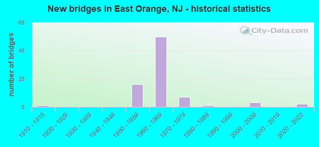
- New bridges - historical statistics
- 11910-1919
- 161950-1959
- 501960-1969
- 71970-1979
- 11980-1989
- 32000-2009
- 22020-2022

- Reconstructed bridges - Historical Statistics
- 21970-1979
- 81980-1989
- 11990-1999
- 12000-2009


- Bridge Condition - Deck
- 23.1%Good
- 46.2%Satisfactory
- 28.2%Fair
- 2.6%Poor

- Bridge Condition - Superstructure
- 2.5%Excellent
- 2.5%Very good
- 57.5%Good
- 25.0%Satisfactory
- 12.5%Fair

- Bridge Condition - Substructure
- 2.5%Excellent
- 5.0%Good
- 67.5%Satisfactory
- 25.0%Fair

- Bridge Condition - Channel
- 20.0%Good
- 40.0%Satisfactory
- 20.0%Fair
- 20.0%Poor
Find on map >> Show street view
Structure Number: 361484T, Location: 1.29 M N OF GSP&RT280 JCT (Lat: 40.776647, Lng: -74.201750), Route carried "on" structure: City street , Year Built: 1954, Year Reconstructed: 1986, Status: Open, Structure Length: 3.44m (11.29ft), Average Daily Traffic: 2,848 (year 2021), Truck Traffic: 1%, Average Future Daily Traffic: 3,475 (year 2041), Design Load: H 20, Features Intersected: GSP NB & SB, Facility Carried by Structure: RENSHAW AVE
Minimum Vertical Clearance: 30+ m (98+ ft), Kilometerpoint: 0.451, Lanes on structure: 2, Lanes under structure: 8, Owner: State Toll Authority, Approaching Roadway Width: 9.8m (32.2ft), Material/Design: Steel, Design/Construction: Stringer/Multi-beam, Number Of Spans In Main Unit: 2, Length of Maximum Span: 16.5m (54.1ft), Curb or Sidewalk Widths: Left: 2.8m (9.2ft), Right: 2.8m (9.2ft), Curb-To-Curb Width: 9.8m (32.2ft), Out-to-Out Width: 15.3m (50.2ft)
Condition: Deck: Good, Superstructure: Good, Substructure: Satisfactory, Operating Rating: 49.2 metric tons, Method Used To Determine Operating Rating: Load and Resistance Factor Rating (LRFR) rating reported by rating factor(RF) method using HL-93 loadings, Inventory Rating: 37.9 metric tons, Method Used To Determine Inventory Rating: Load and Resistance Factor Rating (LRFR) rating reported by rating factor(RF) method using HL-93 loadings, Structural Evaluation: Equal to present minimum criteria, Deck Geometry: Meets minimum limits, Underclear: High priority of corrective action, Approach Roadway Alignment: Equal to present minimum criteria, Length Of Structure Improvement: 3.44m (11.29ft), Designated Inspection Frequency: Every 24 months, Inspection Date: August 2021, Bridge Improvement Cost: $900,000, Roadway Improvement Cost: $150,000, Total Project Cost: $1,420,000 ( Estimate for 2015), Deck Structure Type: Concrete Cast-file-Place, Wearing Surface/Protective System: Wearing Surface: Monolithic Concrete, Deck Protection: Epoxy Coated Reinforcing
Find on map >> Show street view
Structure Number: 361487T, Location: 2 M S OF ESSEX TOLL PLAZA (Lat: 40.780472, Lng: -74.201228), Route carried "on" structure: Other road GSP, Year Built: 1954, Year Reconstructed: 1984, Status: Open, Structure Length: 2.13m (6.99ft), Average Daily Traffic: 195,499 (year 2021), Truck Traffic: 1%, Average Future Daily Traffic: 285,335 (year 2041), Design Load: H 20, Features Intersected: ERIE-LACKAWANNA RR ABND
Minimum Vertical Clearance: 30+ m (98+ ft), Kilometerpoint: 239.309, Lanes on structure: 11, Base Highway Network: Yes, Toll: On toll road, Owner: State Toll Authority, Approaching Roadway Width: 45.7m (149.9ft), Skew: 31 degrees, Material/Design: Steel, Design/Construction: Stringer/Multi-beam, Number Of Spans In Main Unit: 1, Length of Maximum Span: 19.8m (65.0ft), Curb or Sidewalk Widths: Left: 1.8m (5.9ft), Right: 1.8m (5.9ft), Curb-To-Curb Width: 45.7m (149.9ft), Out-to-Out Width: 53.3m (174.9ft)
Condition: Deck: Satisfactory, Superstructure: Good, Substructure: Satisfactory, Operating Rating: 43.4 metric tons, Method Used To Determine Operating Rating: Load and Resistance Factor Rating (LRFR) rating reported by rating factor(RF) method using HL-93 loadings, Inventory Rating: 33.4 metric tons, Method Used To Determine Inventory Rating: Load and Resistance Factor Rating (LRFR) rating reported by rating factor(RF) method using HL-93 loadings, Structural Evaluation: Equal to present minimum criteria, Deck Geometry: Equal to present minimum criteria, Approach Roadway Alignment: Equal to present minimum criteria, Designated Inspection Frequency: Every 24 months, Inspection Date: September 2021, Deck Structure Type: Concrete Cast-file-Place, Wearing Surface/Protective System: Wearing Surface: Latex Concrete, Deck Protection: Epoxy Coated Reinforcing
Find on map >> Show street view
Structure Number: 371467T, Location: 0.4 MILES SOUTH OF I280 (Lat: 40.753031, Lng: -74.210964), Route carried "on" structure: County highway 508, Year Built: 2020, Status: Open, Structure Length: 4.18m (13.71ft), Average Daily Traffic: 11,079 (year 2021), Truck Traffic: 8%, Average Future Daily Traffic: 13,519 (year 2041), Design Load: HL 93, Features Intersected: GARDEN STATE PARKWAY, Facility Carried by Structure: CENTRAL AVENUE
Minimum Vertical Clearance: 30+ m (98+ ft), Kilometerpoint: 14.355, Lanes on structure: 6, Lanes under structure: 10, Base Highway Network: Yes, Owner: State Toll Authority, Approaching Roadway Width: 26.2m (86.0ft), Material/Design: Steel, Design/Construction: Stringer/Multi-beam, Number Of Spans In Main Unit: 1, Length of Maximum Span: 40.8m (133.9ft), Curb or Sidewalk Widths: Left: 2.4m (7.9ft), Right: 2.4m (7.9ft), Curb-To-Curb Width: 22.9m (75.1ft), Out-to-Out Width: 28.3m (92.8ft)
Condition: Deck: Good, Superstructure: Excellent, Substructure: Excellent, Operating Rating: 59.9 metric tons, Method Used To Determine Operating Rating: Load and Resistance Factor Rating (LRFR) rating reported by rating factor(RF) method using HL-93 loadings, Inventory Rating: 46.0 metric tons, Method Used To Determine Inventory Rating: Load and Resistance Factor Rating (LRFR) rating reported by rating factor(RF) method using HL-93 loadings, Structural Evaluation: Superior to present desirable criteria, Deck Geometry: Meets minimum limits, Underclear: High priority of corrective action, Approach Roadway Alignment: Equal to present desirable criteria, Designated Inspection Frequency: Every 24 months, Inspection Date: September 2021, Deck Structure Type: Concrete Cast-file-Place, Wearing Surface/Protective System: Wearing Surface: Monolithic Concrete, Deck Protection: Epoxy Coated Reinforcing
Find on map >> Show street view
Structure Number: 73016, Location: 0.8 MI W OF GSP JCT (Lat: 40.765681, Lng: -74.221169), Route carried "under" structure: Interstate 280, Year Built: 1966, Structure Length: 0. m, Average Daily Traffic: 124,700 (year 2021), Truck Traffic: 9%, Features Intersected: I-280, Facility Carried by Structure: HARRISON ST
Minimum Vertical Clearance: 5.23m (17.16ft), Kilometerpoint: 18.186, Lanes on structure: 4, Lanes under structure: 6, Material/Design: Steel, Design/Construction: Stringer/Multi-beam, Length of Maximum Span: 24.7m (81.0ft)
Find on map >> Show street view
Structure Number: 730161, Location: 0.7 MI W OF 280-GSP JCT (Lat: 40.765539, Lng: -74.219719), Route carried "under" structure: Interstate 280, Year Built: 1966, Structure Length: 0. m, Average Daily Traffic: 106,060 (year 2020), Truck Traffic: 9%, Features Intersected: I-280, Facility Carried by Structure: EVERGREEN PL SB
Minimum Vertical Clearance: 4.78m (15.68ft), Kilometerpoint: 18.330, Lanes on structure: 2, Lanes under structure: 6, Material/Design: Steel, Design/Construction: Stringer/Multi-beam, Length of Maximum Span: 25.6m (84.0ft)
Find on map >> Show street view
Structure Number: 730162, Location: 0.7 MI W OF 280-GSP JCT (Lat: 40.765019, Lng: -74.219561), Route carried "under" structure: Interstate 280, Year Built: 1966, Structure Length: 0. m, Average Daily Traffic: 106,060 (year 2020), Truck Traffic: 9%, Features Intersected: ROUTE I-280, Facility Carried by Structure: EVERGREEN PLACE NB
Minimum Vertical Clearance: 4.72m (15.49ft), Kilometerpoint: 18.363, Lanes on structure: 2, Lanes under structure: 6, Material/Design: Steel, Design/Construction: Stringer/Multi-beam, Length of Maximum Span: 27.7m (90.9ft)
Find on map >> Show street view
Structure Number: 730163, Location: 0.6 MI W OF 280-GSP JCT (Lat: 40.764419, Lng: -74.218361), Route carried "under" structure: Interstate 280, Year Built: 1966, Structure Length: 0. m, Average Daily Traffic: 123,505 (year 2020), Truck Traffic: 9%, Features Intersected: I-280, Facility Carried by Structure: HALSTED STREET
Minimum Vertical Clearance: 4.67m (15.32ft), Kilometerpoint: 18.475, Lanes on structure: 4, Lanes under structure: 6, Material/Design: Steel, Design/Construction: Stringer/Multi-beam, Length of Maximum Span: 24.7m (81.0ft)
Find on map >> Show street view
Structure Number: 730164, Location: 0.46 MI WEST OF GSP JCT (Lat: 40.763119, Lng: -74.216169), Route carried "under" structure: Interstate 280, Year Built: 1966, Structure Length: 0. m, Average Daily Traffic: 124,700 (year 2021), Truck Traffic: 9%, Features Intersected: I-280, Facility Carried by Structure: SOUTH CLINTON ST.
Minimum Vertical Clearance: 5.11m (16.77ft), Kilometerpoint: 18.701, Lanes on structure: 4, Lanes under structure: 6, Material/Design: Steel, Design/Construction: Stringer/Multi-beam, Length of Maximum Span: 24.7m (81.0ft)
Find on map >> Show street view
Structure Number: 730165, Location: 0.4 MI W OF 280-GSP JCT (Lat: 40.762419, Lng: -74.215111), Route carried "under" structure: Interstate 280, Year Built: 1966, Structure Length: 0. m, Average Daily Traffic: 96,828 (year 2020), Truck Traffic: 9%, Features Intersected: I-280, Facility Carried by Structure: SOUTH BURNET ST.
Minimum Vertical Clearance: 4.57m (14.99ft), Kilometerpoint: 18.813, Lanes on structure: 2, Lanes under structure: 6, Material/Design: Steel, Design/Construction: Stringer/Multi-beam, Length of Maximum Span: 24.7m (81.0ft)
Find on map >> Show street view
Structure Number: 730166, Location: 0.3 MI W OF 280-GSP JCT (Lat: 40.761681, Lng: -74.213961), Route carried "under" structure: Interstate 280, Year Built: 1966, Structure Length: 0. m, Average Daily Traffic: 96,828 (year 2020), Truck Traffic: 9%, Features Intersected: I-280, Facility Carried by Structure: SOUTH WALNUT ST.
Minimum Vertical Clearance: 4.57m (14.99ft), Kilometerpoint: 18.942, Lanes on structure: 4, Lanes under structure: 7, Material/Design: Steel, Design/Construction: Stringer/Multi-beam, Length of Maximum Span: 26.2m (86.0ft)
Find on map >> Show street view
Structure Number: 730167, Location: 0.15 MI W OF GSP JCT (Lat: 40.760200, Lng: -74.211281), Route carried "under" structure: Interstate 280, Year Built: 1966, Structure Length: 0. m, Average Daily Traffic: 97,800 (year 2021), Truck Traffic: 9%, Features Intersected: I-280, Facility Carried by Structure: S. ARLINGTON AVE.
Minimum Vertical Clearance: 4.98m (16.34ft), Kilometerpoint: 19.216, Lanes on structure: 4, Lanes under structure: 12, Material/Design: Steel, Design/Construction: Stringer/Multi-beam, Length of Maximum Span: 35.7m (117.1ft)
Find on map >> Show street view
Structure Number: 730168, Location: 0.1 MI W OF I-280-GSP JCT (Lat: 40.759569, Lng: -74.209931), Route carried "under" structure: Interstate 280, Year Built: 1966, Structure Length: 0. m, Average Daily Traffic: 97,800 (year 2021), Truck Traffic: 9%, Features Intersected: I-280, Facility Carried by Structure: NORTH MUNN AVENUE
Minimum Vertical Clearance: 5.66m (18.57ft), Kilometerpoint: 19.360, Lanes on structure: 4, Lanes under structure: 7, Material/Design: Steel, Design/Construction: Stringer/Multi-beam, Length of Maximum Span: 33.2m (108.9ft)
Find on map >> Show street view
Structure Number: 730168, Location: 0.1 MI W OF I-280-GSP JCT (Lat: 40.759569, Lng: -74.209931), Route carried "under" structure: Ramp Interstate 280, Year Built: 1966, Structure Length: 0. m, Average Daily Traffic: 37,700 (year 2021), Truck Traffic: 9%, Features Intersected: I-280, Facility Carried by Structure: NORTH MUNN AVENUE
Minimum Vertical Clearance: 5.94m (19.49ft), Kilometerpoint: 19.360, Lanes on structure: 4, Lanes under structure: 3, Material/Design: Steel, Design/Construction: Stringer/Multi-beam, Length of Maximum Span: 33.2m (108.9ft)
Find on map >> Show street view
Structure Number: 730168, Location: 0.1 MI W OF I-280-GSP JCT (Lat: 40.759569, Lng: -74.209931), Route carried "under" structure: Ramp Interstate 280, Year Built: 1966, Structure Length: 0. m, Average Daily Traffic: 15,800 (year 2021), Truck Traffic: 9%, Features Intersected: I-280, Facility Carried by Structure: NORTH MUNN AVENUE
Minimum Vertical Clearance: 5.28m (17.32ft), Kilometerpoint: 19.360, Lanes on structure: 4, Lanes under structure: 2, Material/Design: Steel, Design/Construction: Stringer/Multi-beam, Length of Maximum Span: 33.2m (108.9ft)
Find on map >> Show street view
Structure Number: 730169, Location: AT 280-GSP JCT (Lat: 40.759169, Lng: -74.209250), Route carried "under" structure: Interstate 280, Year Built: 1966, Structure Length: 0. m, Average Daily Traffic: 97,826 (year 2021), Truck Traffic: 9%, Features Intersected: I-280, Facility Carried by Structure: ORATON PARKWAY SB
Minimum Vertical Clearance: 5.79m (19.00ft), Kilometerpoint: 19.441, Lanes on structure: 2, Lanes under structure: 12, Material/Design: Steel, Design/Construction: Stringer/Multi-beam, Length of Maximum Span: 32.3m (106.0ft)
Find on map >> Show street view
Structure Number: 73017, Location: AT I-280 & GSP JCT (Lat: 40.758989, Lng: -74.208731), Route carried "under" structure: Interstate 280, Year Built: 1966, Structure Length: 0. m, Average Daily Traffic: 107,400 (year 2020), Truck Traffic: 9%, Features Intersected: I-280, Facility Carried by Structure: GARDEN STATE PKWY
Minimum Vertical Clearance: 4.82m (15.81ft), Kilometerpoint: 19.457, Lanes on structure: 8, Lanes under structure: 8, Material/Design: Steel, Design/Construction: Stringer/Multi-beam, Length of Maximum Span: 32.3m (106.0ft)
Find on map >> Show street view
Structure Number: 73017, Location: AT I-280 & GSP JCT (Lat: 40.758989, Lng: -74.208731), Route carried "under" structure: Ramp Interstate 280, Year Built: 1966, Structure Length: 0. m, Average Daily Traffic: 28,720 (year 2020), Truck Traffic: 9%, Features Intersected: I-280, Facility Carried by Structure: GARDEN STATE PKWY
Minimum Vertical Clearance: 4.67m (15.32ft), Kilometerpoint: 19.457, Lanes on structure: 8, Lanes under structure: 2, Material/Design: Steel, Design/Construction: Stringer/Multi-beam, Length of Maximum Span: 32.3m (106.0ft)
Find on map >> Show street view
Structure Number: 73017, Location: AT I-280 & GSP JCT (Lat: 40.758989, Lng: -74.208731), Route carried "under" structure: Ramp Interstate 280, Year Built: 1966, Structure Length: 0. m, Average Daily Traffic: 9,355 (year 2020), Truck Traffic: 9%, Features Intersected: I-280, Facility Carried by Structure: GARDEN STATE PKWY
Minimum Vertical Clearance: 4.88m (16.01ft), Kilometerpoint: 19.457, Lanes on structure: 8, Lanes under structure: 2, Material/Design: Steel, Design/Construction: Stringer/Multi-beam, Length of Maximum Span: 32.3m (106.0ft)
Find on map >> Show street view
Structure Number: 730171, Location: AT 280-GSP JCT (Lat: 40.758739, Lng: -74.208361), Route carried "under" structure: Interstate 280, Year Built: 1966, Structure Length: 0. m, Average Daily Traffic: 112,474 (year 2021), Truck Traffic: 9%, Features Intersected: I-280, Facility Carried by Structure: ORATON PARKWAY NB
Minimum Vertical Clearance: 6.55m (21.49ft), Kilometerpoint: 19.505, Lanes on structure: 2, Lanes under structure: 12, Material/Design: Steel, Design/Construction: Stringer/Multi-beam, Length of Maximum Span: 34.4m (112.9ft)
Find on map >> Show street view
Structure Number: 730172, Location: 0.2 MI E OF 280-GSP JCT (Lat: 40.757739, Lng: -74.205119), Route carried "under" structure: Ramp Interstate 280, Year Built: 1970, Structure Length: 0. m, Average Daily Traffic: 19,100 (year 2021), Truck Traffic: 1%, Features Intersected: RAMP A
Minimum Vertical Clearance: 4.50m (14.76ft), Kilometerpoint: 19.827, Lanes on structure: 7, Lanes under structure: 1, Material/Design: Steel, Design/Construction: Stringer/Multi-beam, Length of Maximum Span: 17.4m (57.1ft)
Find on map >> Show street view
Structure Number: 73018, Location: 0.3 MILES EAST OF GSP (Lat: 40.757219, Lng: -74.203831), Route carried "under" structure: Interstate 280, Year Built: 1971, Structure Length: 0. m, Average Daily Traffic: 108,548 (year 2021), Truck Traffic: 9%, Features Intersected: I-280, Facility Carried by Structure: GROVE ST (RT 509)
Minimum Vertical Clearance: 5.79m (19.00ft), Kilometerpoint: 19.940, Lanes on structure: 4, Lanes under structure: 10, Material/Design: Steel, Design/Construction: Stringer/Multi-beam, Length of Maximum Span: 35.1m (115.2ft)
Find on map >> Show street view
Structure Number: 730181, Location: 0.4 MI E OF 280-GSP JCT (Lat: 40.756150, Lng: -74.201261), Route carried "under" structure: Interstate 280, Year Built: 1970, Structure Length: 0. m, Average Daily Traffic: 97,800 (year 2021), Truck Traffic: 9%, Features Intersected: I-280, Facility Carried by Structure: STEUBEN ST
Minimum Vertical Clearance: 5.05m (16.57ft), Kilometerpoint: 20.181, Lanes on structure: 2, Lanes under structure: 10, Material/Design: Steel, Design/Construction: Stringer/Multi-beam, Length of Maximum Span: 31.1m (102.0ft)
Find on map >> Show street view
Structure Number: 730193, Location: 0.04mi N of I-280&GSP JCT (Lat: 40.759539, Lng: -74.207939), Route carried "under" structure: City street , Year Built: 1965, Structure Length: 0. m, Average Daily Traffic: 7,440 (year 2021), Truck Traffic: 1%, Features Intersected: GSP & ORATON PARKWAY, Facility Carried by Structure: MAIN STREET
Minimum Vertical Clearance: 6.61m (21.69ft), Kilometerpoint: 0.000, Lanes on structure: 4, Lanes under structure: 3, Material/Design: Steel, Design/Construction: Stringer/Multi-beam, Length of Maximum Span: 50.3m (165.0ft)
Find on map >> Show street view
Structure Number: 730193, Location: 0.04mi N of I-280&GSP JCT (Lat: 40.759539, Lng: -74.207939), Route carried "under" structure: Other road GSP, Year Built: 1965, Structure Length: 0. m, Average Daily Traffic: 177,202 (year 2021), Features Intersected: GSP & ORATON PARKWAY, Facility Carried by Structure: MAIN STREET
Minimum Vertical Clearance: 4.88m (16.01ft), Kilometerpoint: 236.847, Lanes on structure: 4, Lanes under structure: 8, Toll: On toll road, Material/Design: Steel, Design/Construction: Stringer/Multi-beam, Length of Maximum Span: 50.3m (165.0ft)
Find on map >> Show street view
Structure Number: 730194, Location: 0.2 MI E OF 280-GSP JCT (Lat: 40.757519, Lng: -74.204969), Route carried "under" structure: Ramp Interstate 280, Year Built: 2007, Structure Length: 0. m, Average Daily Traffic: 17,680 (year 2020), Truck Traffic: 9%, Features Intersected: I-280 & RAMP A
Minimum Vertical Clearance: 10.69m (35.07ft), Kilometerpoint: 19.811, Lanes on structure: 2, Lanes under structure: 1, Material/Design: Steel, Design/Construction: Stringer/Multi-beam, Length of Maximum Span: 46.9m (153.9ft)
Find on map >> Show street view
Structure Number: 730194, Location: 0.2 MI E OF 280-GSP JCT (Lat: 40.757519, Lng: -74.204969), Route carried "under" structure: Interstate 280, Year Built: 2007, Structure Length: 0. m, Average Daily Traffic: 99,120 (year 2020), Truck Traffic: 9%, Features Intersected: I-280 & RAMP A
Minimum Vertical Clearance: 6.35m (20.83ft), Kilometerpoint: 19.811, Lanes on structure: 2, Lanes under structure: 7, Material/Design: Steel, Design/Construction: Stringer/Multi-beam, Length of Maximum Span: 46.9m (153.9ft)
Find on map >> Show street view
Structure Number: 361464T, Location: 0.7 MI S OF GSP&RT280 JCT (Lat: 40.749239, Lng: -74.212469), Route carried "under" structure: Other road GSP, Year Built: 1953, Structure Length: 0. m, Average Daily Traffic: 228,227 (year 2021), Truck Traffic: 1%, Features Intersected: GSP NB & SB, Facility Carried by Structure: MAYBAUM AVE
Minimum Vertical Clearance: 4.57m (14.99ft), Kilometerpoint: 235.672, Lanes on structure: 1, Lanes under structure: 8, Toll: On toll road, Material/Design: Steel, Design/Construction: Stringer/Multi-beam, Length of Maximum Span: 25.0m (82.0ft)
Find on map >> Show street view
Structure Number: 361469T, Location: 0.25 MI S OF GSP&RT280 JC (Lat: 40.755997, Lng: -74.209964), Route carried "under" structure: Ramp Other road GSP, Year Built: 1964, Structure Length: 0. m, Average Daily Traffic: 40,762 (year 2021), Truck Traffic: 1%, Features Intersected: RAMP SB ENT FROM I-280
Minimum Vertical Clearance: 4.57m (14.99ft), Kilometerpoint: 236.557, Lanes on structure: 6, Lanes under structure: 2, Toll: On toll road, Material/Design: Steel, Design/Construction: Stringer/Multi-beam, Length of Maximum Span: 30.2m (99.1ft)
Find on map >> Show street view
Structure Number: 361470B, Location: AT GSP & RT 280 JUNCTION (Lat: 40.755303, Lng: -74.209631), Route carried "under" structure: Ramp Other road GSP, Year Built: 1964, Structure Length: 0. m, Average Daily Traffic: 5,982 (year 2021), Truck Traffic: 1%, Features Intersected: RAMP-GSP NB.EX.TO I-280, Facility Carried by Structure: ORATON PARKWAY NB
Minimum Vertical Clearance: 4.80m (15.75ft), Kilometerpoint: 236.574, Lanes on structure: 2, Lanes under structure: 2, Toll: On toll road, Material/Design: Steel, Design/Construction: Stringer/Multi-beam, Length of Maximum Span: 17.1m (56.1ft)
Find on map >> Show street view
Structure Number: 361470C, Location: AT GSP & RT 280 JUNCTION (Lat: 40.756133, Lng: -74.209408), Route carried "under" structure: Ramp Other road GSP, Year Built: 1964, Structure Length: 0. m, Average Daily Traffic: 8,863 (year 2021), Truck Traffic: 1%, Features Intersected: RAMP G-SB ENT FR.RTE280, Facility Carried by Structure: ORATON PARKWAY NB
Minimum Vertical Clearance: 4.42m (14.50ft), Kilometerpoint: 236.574, Lanes on structure: 2, Lanes under structure: 2, Toll: On toll road, Material/Design: Steel, Design/Construction: Stringer/Multi-beam, Length of Maximum Span: 14.0m (45.9ft)
Find on map >> Show street view
Structure Number: 361470D, Location: AT GSP & RT 280 JUNCTION (Lat: 40.756606, Lng: -74.209347), Route carried "under" structure: Ramp Other road GSP, Year Built: 1964, Structure Length: 0. m, Average Daily Traffic: 9,607 (year 2021), Truck Traffic: 1%, Features Intersected: RAMP I-NB ENT FR I-280, Facility Carried by Structure: ORATON PARKWAY NB
Minimum Vertical Clearance: 4.40m (14.44ft), Kilometerpoint: 236.574, Lanes on structure: 2, Lanes under structure: 1, Toll: On toll road, Material/Design: Steel, Design/Construction: Stringer/Multi-beam, Length of Maximum Span: 27.1m (88.9ft)
Find on map >> Show street view
Structure Number: 361470F, Location: AT GSP & RT 280 JCT (Lat: 40.755981, Lng: -74.205786), Route carried "under" structure: Ramp Other road GSP, Year Built: 1964, Structure Length: 0. m, Average Daily Traffic: 53,043 (year 2021), Truck Traffic: 1%, Features Intersected: RAMP BTW TOLL PL & 280, Facility Carried by Structure: SUSSEX AVE
Minimum Vertical Clearance: 5.59m (18.34ft), Kilometerpoint: 236.557, Lanes on structure: 2, Lanes under structure: 3, Toll: On toll road, Material/Design: Steel, Design/Construction: Stringer/Multi-beam, Length of Maximum Span: 23.8m (78.1ft)
Find on map >> Show street view
Structure Number: 361470F, Location: AT GSP & RT 280 JCT (Lat: 40.755981, Lng: -74.205786), Route carried "under" structure: Ramp Other road GSP, Year Built: 1964, Structure Length: 0. m, Average Daily Traffic: 43,752 (year 2021), Truck Traffic: 1%, Features Intersected: RAMP BTW TOLL PL & 280, Facility Carried by Structure: SUSSEX AVE
Minimum Vertical Clearance: 4.62m (15.16ft), Kilometerpoint: 236.557, Lanes on structure: 2, Lanes under structure: 3, Toll: On toll road, Material/Design: Steel, Design/Construction: Stringer/Multi-beam, Length of Maximum Span: 23.8m (78.1ft)
Find on map >> Show street view
Structure Number: 361470T, Location: AT GSP & RT 280 JCT (Lat: 40.756131, Lng: -74.209875), Route carried "under" structure: Other road GSP, Year Built: 1964, Structure Length: 0. m, Average Daily Traffic: 234,980 (year 2021), Truck Traffic: 1%, Features Intersected: GSP NB&SB,ORATON PKWY, Facility Carried by Structure: RAMP F
Minimum Vertical Clearance: 4.98m (16.34ft), Kilometerpoint: 236.574, Lanes on structure: 1, Lanes under structure: 6, Toll: On toll road, Material/Design: Steel, Design/Construction: Stringer/Multi-beam, Length of Maximum Span: 32.3m (106.0ft)
Find on map >> Show street view
Structure Number: 361470T, Location: AT GSP & RT 280 JCT (Lat: 40.756131, Lng: -74.209875), Route carried "under" structure: City street , Year Built: 1964, Structure Length: 0. m, Average Daily Traffic: 7,363 (year 2021), Truck Traffic: 1%, Features Intersected: GSP NB&SB,ORATON PKWY, Facility Carried by Structure: RAMP F
Minimum Vertical Clearance: 4.67m (15.32ft), Kilometerpoint: 0.000, Lanes on structure: 1, Lanes under structure: 2, Material/Design: Steel, Design/Construction: Stringer/Multi-beam, Length of Maximum Span: 32.3m (106.0ft)
Find on map >> Show street view
Structure Number: 361471T, Location: 0.1 MILES SOUTH OF I-280 (Lat: 40.758244, Lng: -74.209192), Route carried "under" structure: Other road GSP, Year Built: 1964, Structure Length: 0. m, Average Daily Traffic: 169,575 (year 2021), Truck Traffic: 1%, Features Intersected: GARDEN STATE PARKWAY, Facility Carried by Structure: FREEWAY DRIVE EAST
Minimum Vertical Clearance: 4.70m (15.42ft), Kilometerpoint: 236.686, Lanes on structure: 4, Lanes under structure: 8, Toll: On toll road, Material/Design: Steel, Design/Construction: Stringer/Multi-beam, Length of Maximum Span: 27.7m (90.9ft)
Find on map >> Show street view
Structure Number: 361474T, Location: 0.28 MI N OF GSP&RT280 JC (Lat: 40.762942, Lng: -74.206433), Route carried "under" structure: Other road GSP, Year Built: 1953, Structure Length: 0. m, Average Daily Traffic: 230,349 (year 2021), Truck Traffic: 1%, Features Intersected: GSP NB & SB, Facility Carried by Structure: WILLIAM ST
Minimum Vertical Clearance: 4.55m (14.93ft), Kilometerpoint: 237.266, Lanes on structure: 3, Lanes under structure: 6, Toll: On toll road, Material/Design: Steel, Design/Construction: Stringer/Multi-beam, Length of Maximum Span: 16.5m (54.1ft)
Find on map >> Show street view
Structure Number: 361477T, Location: 0.6 MILES NORTH OF I280 (Lat: 40.766372, Lng: -74.204656), Route carried "under" structure: Other road GSP, Year Built: 1953, Structure Length: 0. m, Average Daily Traffic: 181,161 (year 2021), Truck Traffic: 1%, Features Intersected: GARDEN STATE PARKWAY, Facility Carried by Structure: PARK AVENUE
Minimum Vertical Clearance: 5.05m (16.57ft), Kilometerpoint: 237.684, Lanes on structure: 4, Lanes under structure: 6, Toll: On toll road, Material/Design: Steel, Design/Construction: Stringer/Multi-beam, Length of Maximum Span: 18.3m (60.0ft)
Find on map >> Show street view
Structure Number: 361479T, Location: 0.76 MI N OF GSP&RT280 JC (Lat: 40.769400, Lng: -74.204389), Route carried "under" structure: Other road GSP, Year Built: 1954, Structure Length: 0. m, Average Daily Traffic: 230,349 (year 2021), Truck Traffic: 1%, Features Intersected: GSP NB & SB, Facility Carried by Structure: N ARLINGTON AVE
Minimum Vertical Clearance: 4.78m (15.68ft), Kilometerpoint: 238.038, Lanes on structure: 3, Lanes under structure: 6, Toll: On toll road, Material/Design: Steel, Design/Construction: Stringer/Multi-beam, Length of Maximum Span: 25.3m (83.0ft)
Find on map >> Show street view
Structure Number: 361480T, Location: 0.93 MILES NORTH OF I-280 (Lat: 40.771933, Lng: -74.204889), Route carried "under" structure: Other road GSP, Year Built: 1954, Structure Length: 0. m, Average Daily Traffic: 188,276 (year 2021), Truck Traffic: 1%, Features Intersected: GSP, Facility Carried by Structure: SPRINGDALE AVE
Minimum Vertical Clearance: 4.95m (16.24ft), Kilometerpoint: 238.312, Lanes on structure: 4, Lanes under structure: 6, Toll: On toll road, Material/Design: Steel, Design/Construction: Stringer/Multi-beam, Length of Maximum Span: 22.9m (75.1ft)
Find on map >> Show street view
Structure Number: 361481T, Location: 0.97 M N OF GSP&RT280 JCT (Lat: 40.772344, Lng: -74.204892), Route carried "under" structure: Other road GSP, Year Built: 1953, Structure Length: 0. m, Average Daily Traffic: 188,276 (year 2021), Truck Traffic: 1%, Features Intersected: GSP NB & SB, Facility Carried by Structure: N.WALNUT ST
Minimum Vertical Clearance: 4.93m (16.17ft), Kilometerpoint: 238.376, Lanes on structure: 1, Lanes under structure: 6, Toll: On toll road, Material/Design: Steel, Design/Construction: Stringer/Multi-beam, Length of Maximum Span: 22.3m (73.2ft)
Find on map >> Show street view
Structure Number: 361484T, Location: 1.29 M N OF GSP&RT280 JCT (Lat: 40.776647, Lng: -74.201750), Route carried "under" structure: Other road GSP, Year Built: 1954, Structure Length: 0. m, Average Daily Traffic: 184,187 (year 2021), Truck Traffic: 1%, Features Intersected: GSP NB & SB, Facility Carried by Structure: RENSHAW AVE
Minimum Vertical Clearance: 4.72m (15.49ft), Kilometerpoint: 238.891, Lanes on structure: 2, Lanes under structure: 8, Toll: On toll road, Material/Design: Steel, Design/Construction: Stringer/Multi-beam, Length of Maximum Span: 16.5m (54.1ft)
Find on map >> Show street view
Structure Number: 371467T, Location: 0.4 MILES SOUTH OF I280 (Lat: 40.753031, Lng: -74.210964), Route carried "under" structure: Other road GSP, Year Built: 2020, Structure Length: 0. m, Average Daily Traffic: 227,755 (year 2021), Truck Traffic: 1%, Features Intersected: GARDEN STATE PARKWAY, Facility Carried by Structure: CENTRAL AVENUE
Minimum Vertical Clearance: 4.60m (15.09ft), Kilometerpoint: 236.107, Lanes on structure: 6, Lanes under structure: 10, Toll: On toll road, Material/Design: Steel, Design/Construction: Stringer/Multi-beam, Length of Maximum Span: 40.8m (133.9ft)