Bridge Statistics for El Dorado, Kansas (KS)
Condition, Traffic, Stress, Structural Evaluation, Project Costs
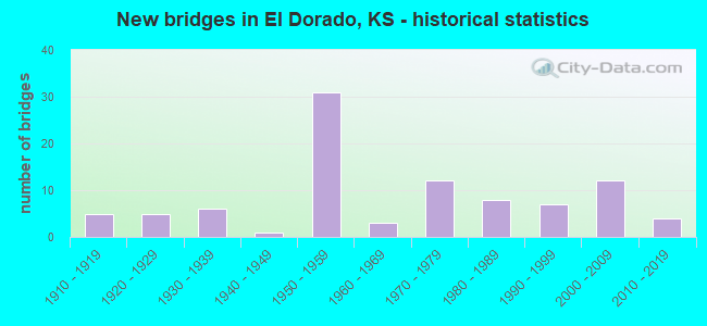
- New bridges - historical statistics
- 51910-1919
- 51920-1929
- 61930-1939
- 11940-1949
- 311950-1959
- 31960-1969
- 121970-1979
- 81980-1989
- 71990-1999
- 122000-2009
- 42010-2019
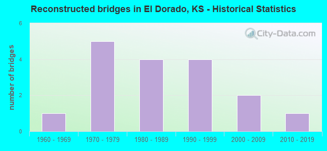
- Reconstructed bridges - Historical Statistics
- 11960-1969
- 51970-1979
- 41980-1989
- 41990-1999
- 22000-2009
- 12010-2019
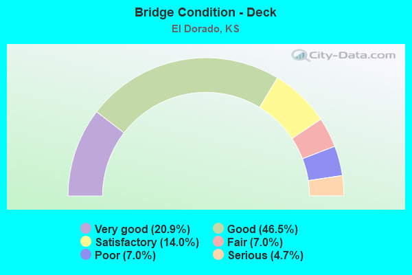
- Bridge Condition - Deck
- 20.9%Very good
- 46.5%Good
- 14.0%Satisfactory
- 7.0%Fair
- 7.0%Poor
- 4.7%Serious
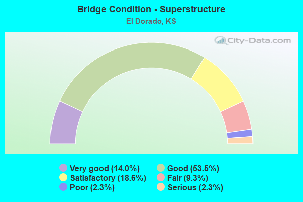
- Bridge Condition - Superstructure
- 14.0%Very good
- 53.5%Good
- 18.6%Satisfactory
- 9.3%Fair
- 2.3%Poor
- 2.3%Serious
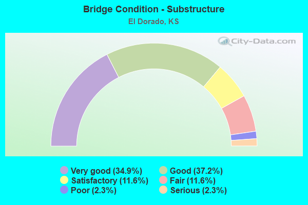
- Bridge Condition - Substructure
- 34.9%Very good
- 37.2%Good
- 11.6%Satisfactory
- 11.6%Fair
- 2.3%Poor
- 2.3%Serious
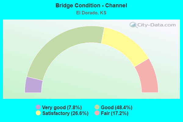
- Bridge Condition - Channel
- 7.8%Very good
- 48.4%Good
- 26.6%Satisfactory
- 17.2%Fair
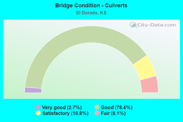
- Bridge Condition - Culverts
- 2.7%Very good
- 78.4%Good
- 10.8%Satisfactory
- 8.1%Fair
Find on map >> Show street view
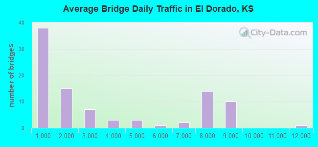
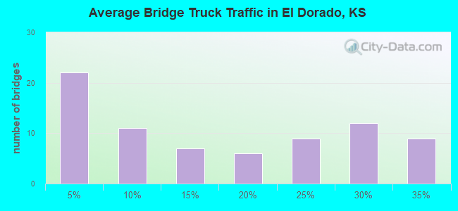
Structure Number: 999903500080923, Location: 0.69 MI NE K-254 (Lat: 37.824444, Lng: -96.896389), Route carried "under" structure: Interstate 35, Year Built: 1956, Structure Length: 0. m, Average Daily Traffic: 8,713 (year 2020), Truck Traffic: 28%, Features Intersected: I-35 HWY (KTA), Facility Carried by Structure: OIL HILL ROAD
Minimum Vertical Clearance: 4.80m (15.75ft), Kilometerpoint: 26.815, Lanes on structure: 2, Lanes under structure: 4, Toll: On Interstate toll segment, Material/Design: Steel continuous, Design/Construction: Stringer/Multi-beam, Length of Maximum Span: 14.0m (45.9ft)
Find on map >> Show street view
Structure Number: 999903500080973, Location: 2.23 MI NE K-254 (Lat: 37.840833, Lng: -96.877222), Route carried "under" structure: Interstate 35, Year Built: 1956, Structure Length: 0. m, Average Daily Traffic: 8,713 (year 2020), Truck Traffic: 28%, Features Intersected: I-35 HWY (KTA), Facility Carried by Structure: OIL HILL ROAD
Minimum Vertical Clearance: 4.57m (14.99ft), Kilometerpoint: 29.290, Lanes on structure: 2, Lanes under structure: 4, Toll: On Interstate toll segment, Material/Design: Steel continuous, Design/Construction: Stringer/Multi-beam, Length of Maximum Span: 23.8m (78.1ft)
Find on map >> Show street view
Structure Number: 999903500081543, Location: 0. MI NE U77 (Lat: 37.875833, Lng: -96.846111), Route carried "under" structure: Interstate 35, Year Built: 1986, Structure Length: 0. m, Average Daily Traffic: 8,713 (year 2020), Truck Traffic: 28%, Features Intersected: I35(KTA) HWY, Facility Carried by Structure: N.ELDORADO IC RAMP
Minimum Vertical Clearance: 4.39m (14.40ft), Kilometerpoint: 34.176, Lanes on structure: 2, Lanes under structure: 5, Toll: On Interstate toll segment, Material/Design: Prestressed concrete continuous, Design/Construction: Stringer/Multi-beam, Length of Maximum Span: 33.8m (110.9ft)
Find on map >> Show street view
Structure Number: 999905400080234, Location: 9.11 MI. N U-400 E JCT (Lat: 37.810000, Lng: -96.849722), Route carried "under" structure: US 54, Year Built: 1923, Structure Length: 0. m, Average Daily Traffic: 2,864 (year 2020), Truck Traffic: 23%, Features Intersected: US54 HWY, Facility Carried by Structure: BNSF RAILROAD
Minimum Vertical Clearance: 4.54m (14.90ft), Kilometerpoint: 42.847, Lanes under structure: 2, Material/Design: Steel, Design/Construction: Stringer/Multi-beam, Length of Maximum Span: 15.9m (52.2ft)
Find on map >> Show street view
Structure Number: 999905400080244, Location: O.51 MI. E US-77 N JCT (Lat: 37.816944, Lng: -96.840278), Route carried "under" structure: US 54, Year Built: 1923, Structure Length: 0. m, Average Daily Traffic: 4,958 (year 2020), Truck Traffic: 12%, Features Intersected: US54 HWY, Facility Carried by Structure: BNSF RAILROAD
Minimum Vertical Clearance: 5.29m (17.36ft), Kilometerpoint: 44.484, Lanes under structure: 2, Material/Design: Prestressed concrete, Design/Construction: Box Beam or Girders - Multiple, Length of Maximum Span: 27.4m (89.9ft)
Find on map >> Show street view
Structure Number: 999907700081174, Location: 1.25 MI. N OF US-54 N JCT (Lat: 37.835278, Lng: -96.849444), Route carried "under" structure: US 77, Year Built: 1973, Structure Length: 0. m, Average Daily Traffic: 5,793 (year 2020), Truck Traffic: 5%, Features Intersected: US 77 HWY, Facility Carried by Structure: BNSF RAILROAD
Minimum Vertical Clearance: 4.81m (15.78ft), Kilometerpoint: 53.509, Lanes under structure: 4, Material/Design: Steel, Design/Construction: Stringer/Multi-beam, Length of Maximum Span: 18.3m (60.0ft)
Find on map >> Show street view
Structure Number: 999907700081761, Location: I-35/US-77 JCTN (Lat: 37.873333, Lng: -96.850000), Route carried "under" structure: Interstate 35, Year Built: 2007, Structure Length: 0. m, Average Daily Traffic: 8,713 (year 2020), Truck Traffic: 28%, Features Intersected: I-35 HWY (KTA), Facility Carried by Structure: US-77 HWY SB
Minimum Vertical Clearance: 5.06m (16.60ft), Kilometerpoint: 33.745, Lanes on structure: 2, Lanes under structure: 4, Toll: On Interstate toll segment, Material/Design: Steel continuous, Design/Construction: Stringer/Multi-beam, Length of Maximum Span: 20.0m (65.6ft)
Find on map >> Show street view
Structure Number: 999907700081901, Location: JCT US-77/I-35 (Lat: 37.873333, Lng: -96.849722), Route carried "under" structure: Interstate 35, Year Built: 2007, Structure Length: 0. m, Average Daily Traffic: 8,713 (year 2020), Truck Traffic: 28%, Features Intersected: I-35 HWY (KTA), Facility Carried by Structure: US-77 HWY NB
Minimum Vertical Clearance: 4.92m (16.14ft), Kilometerpoint: 33.775, Lanes on structure: 2, Lanes under structure: 4, Toll: On Interstate toll segment, Material/Design: Steel continuous, Design/Construction: Stringer/Multi-beam, Length of Maximum Span: 20.0m (65.6ft)
Find on map >> Show street view
Structure Number: 999919600081601, Location: JCT K-196/K-254 (Lat: 37.816111, Lng: -96.919444), Route carried "under" structure: State highway 254, Year Built: 1995, Structure Length: 0. m, Average Daily Traffic: 7,069 (year 2020), Truck Traffic: 8%, Features Intersected: K-254 HWY, Facility Carried by Structure: K-196 HWY
Minimum Vertical Clearance: 4.85m (15.91ft), Kilometerpoint: 21.182, Lanes on structure: 2, Lanes under structure: 4, Material/Design: Prestressed concrete continuous, Design/Construction: Stringer/Multi-beam, Length of Maximum Span: 27.4m (89.9ft)
Find on map >> Show street view
Structure Number: 999925400080631, Location: I-35 (KTA) JCT. (Lat: 37.817222, Lng: -96.905000), Route carried "under" structure: Interstate 35, Year Built: 1956, Structure Length: 0. m, Average Daily Traffic: 8,705 (year 2020), Truck Traffic: 25%, Features Intersected: I-35 HWY (KTA), Facility Carried by Structure: K-254 HWY WB
Minimum Vertical Clearance: 4.67m (15.32ft), Kilometerpoint: 25.714, Lanes on structure: 2, Lanes under structure: 4, Toll: On Interstate toll segment, Material/Design: Steel continuous, Design/Construction: Stringer/Multi-beam, Length of Maximum Span: 19.5m (64.0ft)
Find on map >> Show street view
Structure Number: 999925400081611, Location: I-35/K-254 JCT (Lat: 37.816944, Lng: -96.905556), Route carried "under" structure: Interstate 35, Year Built: 1994, Structure Length: 0. m, Average Daily Traffic: 8,705 (year 2020), Truck Traffic: 25%, Features Intersected: I-35 HWY (KTA), Facility Carried by Structure: K-254 HWY (EB)
Minimum Vertical Clearance: 5.00m (16.40ft), Kilometerpoint: 25.666, Lanes on structure: 2, Lanes under structure: 4, Toll: On Interstate toll segment, Material/Design: Steel continuous, Design/Construction: Stringer/Multi-beam, Length of Maximum Span: 22.3m (73.2ft)