Bridge Statistics for Eldersburg, Maryland (MD)
Condition, Traffic, Stress, Structural Evaluation, Project Costs
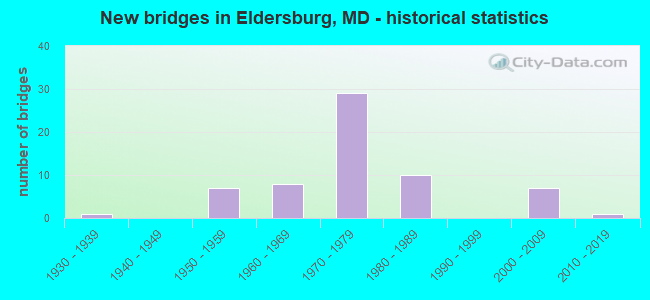
- New bridges - historical statistics
- 11930-1939
- 71950-1959
- 81960-1969
- 291970-1979
- 101980-1989
- 72000-2009
- 12010-2019
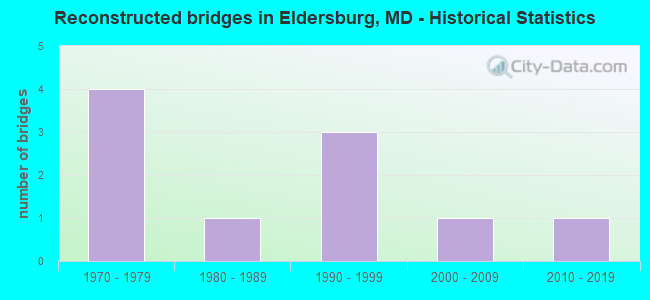
- Reconstructed bridges - Historical Statistics
- 41970-1979
- 11980-1989
- 31990-1999
- 12000-2009
- 12010-2019
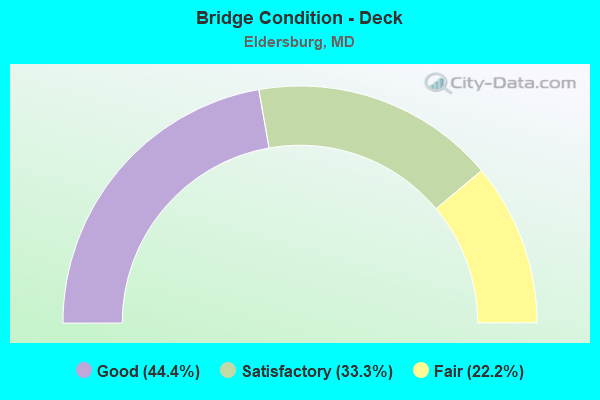
- Bridge Condition - Deck
- 44.4%Good
- 33.3%Satisfactory
- 22.2%Fair
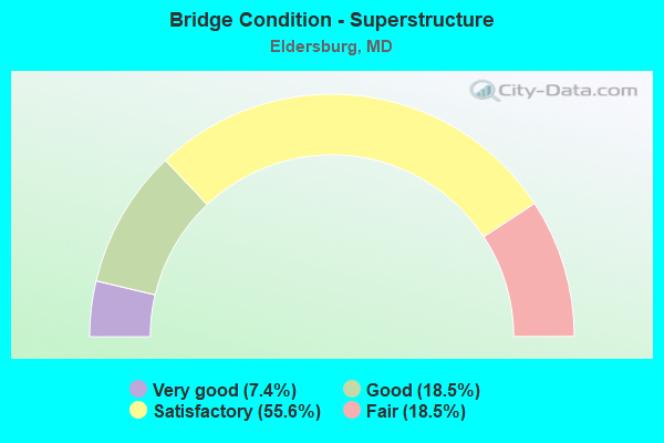
- Bridge Condition - Superstructure
- 7.4%Very good
- 18.5%Good
- 55.6%Satisfactory
- 18.5%Fair
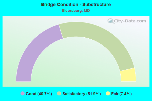
- Bridge Condition - Substructure
- 40.7%Good
- 51.9%Satisfactory
- 7.4%Fair
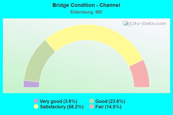
- Bridge Condition - Channel
- 3.6%Very good
- 23.6%Good
- 58.2%Satisfactory
- 14.5%Fair
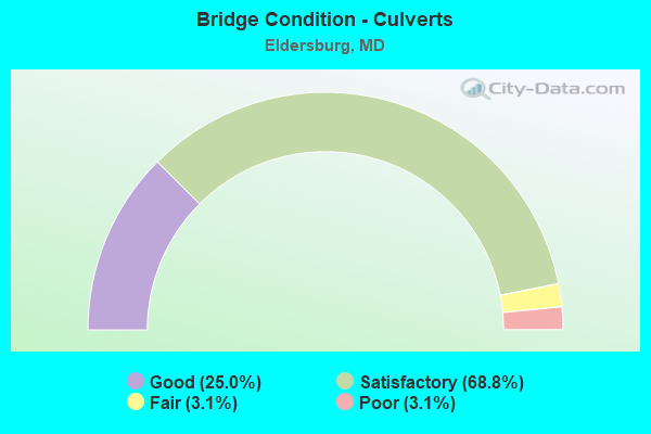
- Bridge Condition - Culverts
- 25.0%Good
- 68.8%Satisfactory
- 3.1%Fair
- 3.1%Poor
Find on map >> Show street view
Structure Number: 200000CL033701, Location: 0.60 MI S OF DEER PARK RD (Lat: 39.462625, Lng: -76.907556), Route carried "on" structure: County highway 639, Year Built: 1974, Status: Open, Structure Length: 1.96m (6.43ft), Average Daily Traffic: 988 (year 2021), Truck Traffic: 8%, Average Future Daily Traffic: 1,620 (year 2041), Features Intersected: MIDDLE RUN, Facility Carried by Structure: LOUISVILLE ROAD
Minimum Vertical Clearance: 30+ m (98+ ft), Kilometerpoint: 2.253, Lanes on structure: 2, Owner: County Highway Agency, Approaching Roadway Width: 7.3m (24.0ft), Skew: 1 degrees, Material/Design: Steel, Design/Construction: Stringer/Multi-beam, Number Of Spans In Main Unit: 1, Length of Maximum Span: 18.3m (60.0ft), Curb-To-Curb Width: 9.8m (32.2ft), Out-to-Out Width: 10.7m (35.1ft)
Condition: Deck: Good, Superstructure: Good, Substructure: Good, Channel: Satisfactory, Inventory Rating: 56.2 metric tons, Method Used To Determine Inventory Rating: Load Factor (LF), Structural Evaluation: Better than present minimum criteria, Deck Geometry: Equal to present minimum criteria, Waterway Adequacy: Better than present minimum criteria, Approach Roadway Alignment: Equal to present desirable criteria, Designated Inspection Frequency: Every 24 months, Inspection Date: August 2021, Deck Structure Type: Concrete Cast-file-Place
Find on map >> Show street view
Structure Number: 200000CL033902, Location: 0.59 MI N OF MD 32 (Lat: 39.475169, Lng: -76.935383), Route carried "on" structure: County highway 539, Year Built: 1974, Status: Open, Structure Length: 0.88m (2.89ft), Average Daily Traffic: 741 (year 2021), Truck Traffic: 8%, Average Future Daily Traffic: 1,220 (year 2041), Features Intersected: SOUTH BRANCH MIDDLE RUN, Facility Carried by Structure: NINER ROAD
Minimum Vertical Clearance: 30+ m (98+ ft), Kilometerpoint: 0.949, Lanes on structure: 2, Owner: County Highway Agency, Approaching Roadway Width: 6.4m (21.0ft), Skew: 2 degrees, Material/Design: Concrete, Design/Construction: Culvert, Number Of Spans In Main Unit: 2, Length of Maximum Span: 3.7m (12.1ft), Curb-To-Curb Width: 9.3m (30.5ft), Out-to-Out Width: 9.9m (32.5ft)
Condition: Channel: Satisfactory, Culverts: Satisfactory, Operating Rating: 66.7 metric tons, Method Used To Determine Operating Rating: Load Factor (LF), Inventory Rating: 39.9 metric tons, Method Used To Determine Inventory Rating: Load Factor (LF), Structural Evaluation: Equal to present minimum criteria, Deck Geometry: Equal to present minimum criteria, Waterway Adequacy: Equal to present minimum criteria, Approach Roadway Alignment: Equal to present desirable criteria, Designated Inspection Frequency: Every 24 months, Inspection Date: August 2021
Find on map >> Show street view
Structure Number: 200000CL034102, Location: 0.23 MI WEST OF MD 91 (Lat: 39.489636, Lng: -76.902844), Route carried "on" structure: County highway 493, Year Built: 1976, Status: Open, Structure Length: 1.52m (4.99ft), Average Daily Traffic: 330 (year 2021), Truck Traffic: 5%, Average Future Daily Traffic: 550 (year 2041), Design Load: H 20, Features Intersected: BEAVER RUN, Facility Carried by Structure: HUGHES ROAD
Minimum Vertical Clearance: 30+ m (98+ ft), Kilometerpoint: 0.370, Lanes on structure: 2, Owner: County Highway Agency, Approaching Roadway Width: 6.1m (20.0ft), Material/Design: Concrete, Design/Construction: Culvert, Length of Maximum Span: 4.9m (16.1ft), Curb-To-Curb Width: 6.7m (22.0ft), Out-to-Out Width: 7.7m (25.3ft)
Condition: Channel: Satisfactory, Culverts: Satisfactory, Operating Rating: 75.7 metric tons, Method Used To Determine Operating Rating: Load Factor (LF), Inventory Rating: 45.4 metric tons, Method Used To Determine Inventory Rating: Load Factor (LF), Structural Evaluation: Equal to present minimum criteria, Deck Geometry: Meets minimum limits, Waterway Adequacy: Better than present minimum criteria, Approach Roadway Alignment: Equal to present minimum criteria, Designated Inspection Frequency: Every 24 months, Inspection Date: June 2021
Find on map >> Show street view
Structure Number: 200000CL034201, Location: 0.09 MI N OF HOWARD CO (Lat: 39.363558, Lng: -77.066047), Route carried "on" structure: County highway 599, Year Built: 2001, Status: Open, Structure Length: 2.27m (7.45ft), Average Daily Traffic: 86 (year 2021), Truck Traffic: 8%, Average Future Daily Traffic: 141 (year 2041), Design Load: HS 25 or greater, Features Intersected: GILLIS FALLS, Facility Carried by Structure: NEWPORT ROAD
Minimum Vertical Clearance: 30+ m (98+ ft), Kilometerpoint: 0.145, Lanes on structure: 2, Owner: County Highway Agency, Approaching Roadway Width: 4.9m (16.1ft), Skew: 1 degrees, Material/Design: Prestressed concrete, Design/Construction: Box Beam or Girders - Multiple, Number Of Spans In Main Unit: 1, Length of Maximum Span: 21.3m (69.9ft), Curb-To-Curb Width: 4.9m (16.1ft), Out-to-Out Width: 5.6m (18.4ft)
Condition: Deck: Good, Superstructure: Very good, Substructure: Good, Channel: Satisfactory, Operating Rating: 72.6 metric tons, Method Used To Determine Operating Rating: Load Factor (LF), Inventory Rating: 43.5 metric tons, Method Used To Determine Inventory Rating: Load Factor (LF), Structural Evaluation: Better than present minimum criteria, Waterway Adequacy: Better than present minimum criteria, Approach Roadway Alignment: Equal to present minimum criteria, Designated Inspection Frequency: Every 24 months, Inspection Date: July 2021, Deck Structure Type: Concrete Cast-file-Place, Wearing Surface/Protective System: Wearing Surface: Integral Concrete
Find on map >> Show street view
Structure Number: 200000CL034301, Location: 0.44 MI S OF MD 140 (Lat: 39.496619, Lng: -76.903447), Route carried "on" structure: County highway 494, Year Built: 1978, Status: Open, Structure Length: 6.25m (20.51ft), Average Daily Traffic: 1,671 (year 2021), Truck Traffic: 23%, Average Future Daily Traffic: 2,738 (year 2041), Design Load: H 20, Features Intersected: BEAVER RUN, Facility Carried by Structure: KAYS MILL ROAD
Minimum Vertical Clearance: 30+ m (98+ ft), Kilometerpoint: 0.708, Lanes on structure: 2, Base Highway Network: Yes, Owner: County Highway Agency, Approaching Roadway Width: 7.3m (24.0ft), Skew: 4 degrees, Material/Design: Steel, Design/Construction: Stringer/Multi-beam, Number Of Spans In Main Unit: 3, Length of Maximum Span: 22.9m (75.1ft), Curb-To-Curb Width: 9.8m (32.2ft), Out-to-Out Width: 10.7m (35.1ft)
Condition: Deck: Satisfactory, Superstructure: Satisfactory, Substructure: Satisfactory, Channel: Satisfactory, Inventory Rating: 58.0 metric tons, Method Used To Determine Inventory Rating: Load Factor (LF), Structural Evaluation: Equal to present minimum criteria, Deck Geometry: Somewhat better than minimum adequacy, Waterway Adequacy: Equal to present desirable criteria, Approach Roadway Alignment: Equal to present minimum criteria, Designated Inspection Frequency: Every 24 months, Inspection Date: June 2021, Deck Structure Type: Concrete Cast-file-Place
Find on map >> Show street view
Structure Number: 200000CL034403, Location: AT HUGHES ROAD (Lat: 39.495458, Lng: -76.901922), Route carried "on" structure: County highway 986, Year Built: 1974, Year Reconstructed: 2001, Status: Posted for load, Structure Length: 1.40m (4.59ft), Average Daily Traffic: 209 (year 2021), Truck Traffic: 10%, Average Future Daily Traffic: 350 (year 2041), Features Intersected: BEAVER RUN, Facility Carried by Structure: OLD KAYS MILL ROAD
Minimum Vertical Clearance: 30+ m (98+ ft), Kilometerpoint: 0.177, Lanes on structure: 2, Owner: County Highway Agency, Approaching Roadway Width: 6.1m (20.0ft), Skew: 3 degrees, Material/Design: Steel, Design/Construction: Culvert, Length of Maximum Span: 3.4m (11.2ft)
Condition: Channel: Satisfactory, Culverts: Poor, Operating Rating: 24.0 metric tons, Method Used To Determine Operating Rating: Allowable Stress (AS), Inventory Rating: 18.1 metric tons, Method Used To Determine Inventory Rating: Allowable Stress (AS), Structural Evaluation: Meets minimum limits, Waterway Adequacy: Better than present minimum criteria, Approach Roadway Alignment: Equal to present minimum criteria, Bridge Posting: Required (Relationship of Operating Rating to Maximum Legal Load: 0.1 - 9.9% below), Designated Inspection Frequency: Every 12 months, Inspection Date: June 2021
Find on map >> Show street view
Structure Number: 200000HO003101, Location: 1 MI S OF MD RTE 144 (Lat: 39.298408, Lng: -76.989308), Route carried "on" structure: County highway 62, Year Built: 1935, Year Reconstructed: 1979, Status: Posted for load, Structure Length: 1.10m (3.61ft), Average Daily Traffic: 1,116 (year 1998), Truck Traffic: 4%, Average Future Daily Traffic: 2,255 (year 2015), Features Intersected: MIDDLE PATUXENT RIVER, Facility Carried by Structure: PFEFFERKORN ROAD
Minimum Vertical Clearance: 5.18m (16.99ft), Kilometerpoint: 2.735, Lanes on structure: 2, Owner: County Highway Agency, Approaching Roadway Width: 6.1m (20.0ft), Material/Design: Steel, Design/Construction: Girder and Floorbeam System, Number Of Spans In Main Unit: 1, Length of Maximum Span: 10.4m (34.1ft), Curb or Sidewalk Widths: Left: 0.2m (0.7ft), Right: 0.2m (0.7ft), Curb-To-Curb Width: 6.1m (20.0ft), Out-to-Out Width: 6.6m (21.7ft)
Condition: Deck: Fair, Superstructure: Fair, Substructure: Good, Channel: Satisfactory, Operating Rating: 28.1 metric tons, Method Used To Determine Operating Rating: Load Factor (LF), Inventory Rating: 16.8 metric tons, Method Used To Determine Inventory Rating: Load Factor (LF), Structural Evaluation: Meets minimum limits, Deck Geometry: High priority of replacement, Waterway Adequacy: Better than present minimum criteria, Approach Roadway Alignment: Equal to present desirable criteria, Bridge Posting: Required (Relationship of Operating Rating to Maximum Legal Load: 10.0 - 19.9% below), Length Of Structure Improvement: 15.24m (50.00ft), Designated Inspection Frequency: Every 24 months, Critical Feature Inspection Frequency: Every 24 months, Inspection Date: March 2020, Critical Feature Inspection Date: March 2020, Bridge Improvement Cost: $459,000, Roadway Improvement Cost: $137,000, Total Project Cost: $596,000, Deck Structure Type: Corrugated Steel, Wearing Surface/Protective System: Wearing Surface: Bituminous
Find on map >> Show street view
Structure Number: 200000HO003901, Location: 0.1 MI W CARRS MILL RD (Lat: 39.314075, Lng: -77.053614), Route carried "on" structure: County highway 924, Year Built: 1970, Status: Open, Structure Length: 0.83m (2.72ft), Average Daily Traffic: 317 (year 2000), Truck Traffic: 4%, Average Future Daily Traffic: 650 (year 2015), Features Intersected: CATTAIL CREEK, Facility Carried by Structure: BUSHY PARK ROAD
Minimum Vertical Clearance: 30+ m (98+ ft), Kilometerpoint: 0.756, Lanes on structure: 2, Owner: County Highway Agency, Approaching Roadway Width: 7.3m (24.0ft), Material/Design: Prestressed concrete, Design/Construction: Box Beam or Girders - Multiple, Number Of Spans In Main Unit: 1, Length of Maximum Span: 7.3m (24.0ft), Curb-To-Curb Width: 2.2m (7.2ft), Out-to-Out Width: 2.3m (7.5ft)
Condition: Deck: Fair, Superstructure: Fair, Substructure: Fair, Channel: Good, Operating Rating: 54.4 metric tons, Method Used To Determine Operating Rating: Load Factor (LF), Inventory Rating: 32.7 metric tons, Method Used To Determine Inventory Rating: Load Factor (LF), Structural Evaluation: Somewhat better than minimum adequacy, Deck Geometry: High priority of replacement, Waterway Adequacy: Better than present minimum criteria, Approach Roadway Alignment: High priority of corrective action, Designated Inspection Frequency: Every 24 months, Other Special Inspection Frequency: Every 12 months, Inspection Date: March 2021, Other Special Inspection Date: March 2021, Deck Structure Type: Concrete Precast Panels, Wearing Surface/Protective System: Wearing Surface: Bituminous
Find on map >> Show street view
Structure Number: 200000HO019903, Location: 0.6 Mile E of McEndree Rd (Lat: 39.301753, Lng: -76.998364), Route carried "on" structure: County highway 39, Year Built: 1970, Status: Open, Structure Length: 0.77m (2.53ft), Average Daily Traffic: 100 (year 2013), Truck Traffic: 2%, Average Future Daily Traffic: 130 (year 2033), Features Intersected: MIDDLE PATUXENT RIVER, Facility Carried by Structure: ROVER MILL ROAD
Minimum Vertical Clearance: 30+ m (98+ ft), Kilometerpoint: 0.000, Lanes on structure: 2, Owner: County Highway Agency, Approaching Roadway Width: 6.1m (20.0ft), Skew: 2 degrees, Material/Design: Steel, Design/Construction: Culvert, Length of Maximum Span: 0.0m
Condition: Channel: Good, Culverts: Good, Operating Rating: 32.7 metric tons, Method Used To Determine Operating Rating: Field evaluation and documented engineering judgment, Inventory Rating: 32.7 metric tons, Method Used To Determine Inventory Rating: Field evaluation and documented engineering judgment, Structural Evaluation: Better than present minimum criteria, Waterway Adequacy: Better than present minimum criteria, Approach Roadway Alignment: Equal to present minimum criteria, Designated Inspection Frequency: Every 24 months, Inspection Date: April 2020
Find on map >> Show street view
Structure Number: 200000HO025003, Location: 1000 FT WEST OF MD 32 (Lat: 39.340011, Lng: -76.957186), Route carried "on" structure: County highway , Year Built: 2000, Status: Open, Structure Length: 1.04m (3.41ft), Average Daily Traffic: 50 (year 2016), Truck Traffic: 1%, Average Future Daily Traffic: 50 (year 2037), Features Intersected: TRIB S BR PATAPSCO RIVER, Facility Carried by Structure: AMBERWOODS WAY
Minimum Vertical Clearance: 30+ m (98+ ft), Kilometerpoint: 0.000, Lanes on structure: 2, Owner: County Highway Agency, Approaching Roadway Width: 7.3m (24.0ft), Skew: 4 degrees, Material/Design: Steel, Design/Construction: Culvert, Length of Maximum Span: 3.0m (9.8ft)
Condition: Channel: Good, Culverts: Satisfactory, Structural Evaluation: Equal to present minimum criteria, Waterway Adequacy: Better than present minimum criteria, Approach Roadway Alignment: Equal to present desirable criteria, Designated Inspection Frequency: Every 24 months, Inspection Date: Febuary 2020
Find on map >> Show street view
Structure Number: 200000HO025103, Location: 2000 FT. WEST OF MD 32 (Lat: 39.340378, Lng: -76.963314), Route carried "on" structure: County highway , Year Built: 2000, Status: Open, Structure Length: 0.70m (2.30ft), Average Daily Traffic: 30 (year 2016), Truck Traffic: 1%, Average Future Daily Traffic: 30 (year 2037), Features Intersected: TRIB S BR PATAPSCO RIVER, Facility Carried by Structure: AMBERWOODS WAY
Minimum Vertical Clearance: 30+ m (98+ ft), Kilometerpoint: 0.000, Lanes on structure: 2, Owner: County Highway Agency, Approaching Roadway Width: 7.3m (24.0ft), Material/Design: Steel, Design/Construction: Culvert, Length of Maximum Span: 3.0m (9.8ft)
Condition: Channel: Satisfactory, Culverts: Good, Structural Evaluation: Better than present minimum criteria, Waterway Adequacy: Better than present minimum criteria, Approach Roadway Alignment: Equal to present desirable criteria, Designated Inspection Frequency: Every 24 months, Inspection Date: Febuary 2020
Find on map >> Show street view
Structure Number: 200000HO025203, Location: 2500' W of Sykesville Rd (Lat: 39.332467, Lng: -76.954775), Route carried "on" structure: County highway , Year Built: 2000, Status: Open, Structure Length: 0.91m (2.99ft), Average Daily Traffic: 20 (year 2016), Truck Traffic: 1%, Average Future Daily Traffic: 20 (year 2037), Features Intersected: TRIB S BR PATAPSCO RIVER, Facility Carried by Structure: COVENTRY MEADOWS
Minimum Vertical Clearance: 30+ m (98+ ft), Kilometerpoint: 0.000, Lanes on structure: 2, Owner: County Highway Agency, Approaching Roadway Width: 6.4m (21.0ft), Skew: 3 degrees, Material/Design: Steel, Design/Construction: Culvert, Length of Maximum Span: 1.5m (4.9ft)
Condition: Channel: Good, Culverts: Good, Structural Evaluation: Better than present minimum criteria, Waterway Adequacy: Better than present minimum criteria, Approach Roadway Alignment: Equal to present desirable criteria, Designated Inspection Frequency: Every 24 months, Inspection Date: Febuary 2020
Find on map >> Show street view
Structure Number: 200000HO025303, Location: 1000 ft East of River Rd (Lat: 39.344244, Lng: -76.945269), Route carried "on" structure: County highway , Year Built: 2000, Status: Open, Structure Length: 0.85m (2.79ft), Average Daily Traffic: 20 (year 2016), Truck Traffic: 1%, Average Future Daily Traffic: 30 (year 2037), Features Intersected: TRIB S BR PATAPSCO RIVER, Facility Carried by Structure: HIGH STEPPER TRAIL
Minimum Vertical Clearance: 30+ m (98+ ft), Kilometerpoint: 0.000, Lanes on structure: 2, Owner: County Highway Agency, Approaching Roadway Width: 7.3m (24.0ft), Skew: 1 degrees, Material/Design: Steel, Design/Construction: Culvert, Length of Maximum Span: 1.8m (5.9ft)
Condition: Channel: Satisfactory, Culverts: Fair, Structural Evaluation: Somewhat better than minimum adequacy, Waterway Adequacy: Equal to present minimum criteria, Approach Roadway Alignment: Equal to present desirable criteria, Designated Inspection Frequency: Every 24 months, Inspection Date: Febuary 2020
Find on map >> Show street view
Structure Number: 200000HO026003, Location: 1/4 MI S OF HOWARD RD (Lat: 39.401739, Lng: -77.020661), Route carried "on" structure: County highway , Year Built: 2000, Status: Open, Structure Length: 0.64m (2.10ft), Average Daily Traffic: 50 (year 2016), Average Future Daily Traffic: 50 (year 2037), Features Intersected: TRIB TO TRIADELPHIA RES, Facility Carried by Structure: BIG BRANCH DRIVE
Minimum Vertical Clearance: 30+ m (98+ ft), Kilometerpoint: 0.000, Lanes on structure: 2, Owner: County Highway Agency, Approaching Roadway Width: 7.0m (23.0ft), Skew: 1 degrees, Material/Design: Steel, Design/Construction: Culvert, Length of Maximum Span: 2.4m (7.9ft)
Condition: Channel: Satisfactory, Culverts: Good, Structural Evaluation: Better than present minimum criteria, Waterway Adequacy: Equal to present desirable criteria, Approach Roadway Alignment: Equal to present desirable criteria, Designated Inspection Frequency: Every 24 months, Inspection Date: Febuary 2020
Find on map >> Show street view
Structure Number: 10000006005401, Location: 1.92 M S OF BARTHOLOW RD (Lat: 39.431708, Lng: -77.006306), Route carried "under" structure: State highway 97, Year Built: 1962, Structure Length: 0. m, Average Daily Traffic: 13,800 (year 2009), Features Intersected: MD 97, Facility Carried by Structure: MD 26
Minimum Vertical Clearance: 5.18m (16.99ft), Kilometerpoint: 9.187, Lanes on structure: 2, Lanes under structure: 2, Material/Design: Steel, Design/Construction: Stringer/Multi-beam, Length of Maximum Span: 25.3m (83.0ft)
Find on map >> Show street view
Structure Number: 100000130030013, Location: .45 MILE NORTH OF MD 144A (Lat: 39.326756, Lng: -77.016875), Route carried "under" structure: State highway 97, Year Built: 1973, Structure Length: 0. m, Average Daily Traffic: 13,020 (year 2009), Features Intersected: MD 97, Facility Carried by Structure: IS 70 EBR
Minimum Vertical Clearance: 5.18m (16.99ft), Kilometerpoint: 10.957, Lanes on structure: 3, Lanes under structure: 4, Material/Design: Steel, Design/Construction: Stringer/Multi-beam, Length of Maximum Span: 43.3m (142.1ft)
Find on map >> Show street view
Structure Number: 100000130030014, Location: .45 MILE NORTH OF MD 144A (Lat: 39.326639, Lng: -77.015853), Route carried "under" structure: State highway 97, Year Built: 1973, Structure Length: 0. m, Average Daily Traffic: 13,020 (year 2009), Features Intersected: MD 97, Facility Carried by Structure: IS 70 WBR
Minimum Vertical Clearance: 5.18m (16.99ft), Kilometerpoint: 10.957, Lanes on structure: 3, Lanes under structure: 4, Material/Design: Steel, Design/Construction: Stringer/Multi-beam, Length of Maximum Span: 43.3m (142.1ft)
Find on map >> Show street view
Structure Number: 10000013008201, Location: 1.9 MILE WEST OF MD 97 (Lat: 39.336989, Lng: -77.048919), Route carried "under" structure: Interstate 70, Year Built: 1973, Structure Length: 0. m, Average Daily Traffic: 71,700 (year 2009), Features Intersected: IS 70, Facility Carried by Structure: MORGAN STATION RD
Minimum Vertical Clearance: 4.88m (16.01ft), Kilometerpoint: 8.174, Lanes on structure: 2, Lanes under structure: 6, Material/Design: Steel continuous, Design/Construction: Stringer/Multi-beam, Length of Maximum Span: 36.6m (120.1ft)