Bridge Statistics for Elkins, West Virginia (WV)
Condition, Traffic, Stress, Structural Evaluation, Project Costs
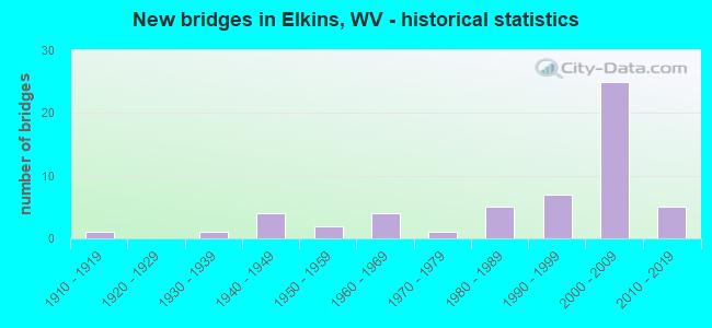
- New bridges - historical statistics
- 11910-1919
- 11930-1939
- 41940-1949
- 21950-1959
- 41960-1969
- 11970-1979
- 51980-1989
- 71990-1999
- 252000-2009
- 52010-2019


- Bridge Condition - Deck
- 44.4%Good
- 38.9%Satisfactory
- 8.3%Fair
- 8.3%Poor

- Bridge Condition - Superstructure
- 43.6%Good
- 30.8%Satisfactory
- 15.4%Fair
- 10.3%Poor

- Bridge Condition - Substructure
- 37.8%Good
- 35.1%Satisfactory
- 21.6%Fair
- 2.7%Poor
- 2.7%Serious

- Bridge Condition - Channel
- 35.1%Very good
- 37.8%Good
- 21.6%Satisfactory
- 2.7%Fair
- 2.7%Poor

- Bridge Condition - Culverts
- 33.3%Good
- 33.3%Satisfactory
- 33.3%Fair
Find on map >> Show street view
Structure Number: 42A241, Location: 0.23 MI W JCT CR 14 (Lat: 38.936750, Lng: -79.877661), Route carried "on" structure: State highway 9200, Year Built: 2012, Status: Open, Structure Length: 5.28m (17.32ft), Average Daily Traffic: 10,500 (year 2018), Truck Traffic: 11%, Average Future Daily Traffic: 13,422 (year 2038), Design Load: HL 93, Features Intersected: LEADING CREEK, Facility Carried by Structure: WV Route 92 (F)
Minimum Vertical Clearance: 30+ m (98+ ft), Kilometerpoint: 56.408, Lanes on structure: 2, Owner: State Highway Agency, Approaching Roadway Width: 12.2m (40.0ft), Material/Design: Prestressed concrete, Design/Construction: Stringer/Multi-beam, Number Of Spans In Main Unit: 2, Length of Maximum Span: 25.9m (85.0ft), Curb-To-Curb Width: 12.2m (40.0ft), Out-to-Out Width: 13.0m (42.7ft)
Condition: Deck: Satisfactory, Superstructure: Satisfactory, Substructure: Good, Channel: Very good, Operating Rating: 49.9 metric tons, Method Used To Determine Operating Rating: Load and Resistance Factor (LRFR), Inventory Rating: 38.1 metric tons, Method Used To Determine Inventory Rating: Load and Resistance Factor (LRFR), Structural Evaluation: Equal to present minimum criteria, Deck Geometry: Somewhat better than minimum adequacy, Waterway Adequacy: Equal to present minimum criteria, Approach Roadway Alignment: Better than present minimum criteria, Designated Inspection Frequency: Every 24 months, Inspection Date: September 2020, Deck Structure Type: Concrete Cast-file-Place, Wearing Surface/Protective System: Wearing Surface: Monolithic Concrete, Membrane: Epoxy, Deck Protection: Epoxy Coated Reinforcing
Find on map >> Show street view
Structure Number: 42A244, Location: 0.84 MI. South Jct. CR. 1 (Lat: 38.936731, Lng: -79.853789), Route carried "on" structure: US 21900, Year Built: 2014, Status: Open, Structure Length: 0.73m (2.40ft), Average Daily Traffic: 15,831 (year 2018), Truck Traffic: 11%, Average Future Daily Traffic: 20,237 (year 2038), Design Load: HL 93, Features Intersected: CRAVEN RUN, Facility Carried by Structure: U.S. 219
Minimum Vertical Clearance: 30+ m (98+ ft), Kilometerpoint: 66.112, Lanes on structure: 2, Base Highway Network: Yes, Owner: State Highway Agency, Approaching Roadway Width: 11.0m (36.1ft), Material/Design: Concrete, Design/Construction: Arch - Deck, Number Of Spans In Main Unit: 1, Length of Maximum Span: 7.3m (24.0ft), Curb or Sidewalk Widths: Left: 1.6m (5.2ft), Right: 0.0m, Curb-To-Curb Width: 12.3m (40.4ft), Out-to-Out Width: 14.6m (47.9ft)
Condition: Superstructure: Good, Channel: Very good, Operating Rating: 88.9 metric tons, Method Used To Determine Operating Rating: Field evaluation and documented engineering judgment, Inventory Rating: 40.8 metric tons, Method Used To Determine Inventory Rating: Field evaluation and documented engineering judgment, Structural Evaluation: Better than present minimum criteria, Deck Geometry: Somewhat better than minimum adequacy, Waterway Adequacy: Equal to present desirable criteria, Approach Roadway Alignment: Equal to present minimum criteria, Designated Inspection Frequency: Every 24 months, Inspection Date: March 2020
Find on map >> Show street view
Structure Number: 42A901, Location: 0.44 MI S JCT RAND. AVE. (Lat: 38.922050, Lng: -79.849739), Route carried "on" structure: City street N0485, Year Built: 1948, Status: Posted for load, Structure Length: 6.00m (19.69ft), Average Daily Traffic: 8,000 (year 2021), Truck Traffic: 5%, Average Future Daily Traffic: 10,226 (year 2041), Features Intersected: TYGART VALLEY RIVER, Facility Carried by Structure: DAVIS AVENUE
Minimum Vertical Clearance: 30+ m (98+ ft), Kilometerpoint: 0.048, Lanes on structure: 2, Owner: City or Municipal Highway Agency, Approaching Roadway Width: 9.8m (32.2ft), Material/Design: Concrete continuous, Design/Construction: Tee Beam, Number Of Spans In Main Unit: 4, Length of Maximum Span: 16.9m (55.4ft), Curb or Sidewalk Widths: Left: 1.9m (6.2ft), Right: 1.9m (6.2ft), Curb-To-Curb Width: 8.5m (27.9ft), Out-to-Out Width: 13.0m (42.7ft)
Condition: Deck: Poor, Superstructure: Poor, Substructure: Poor, Channel: Good, Operating Rating: 42.6 metric tons, Method Used To Determine Operating Rating: Field evaluation and documented engineering judgment, Inventory Rating: 20.0 metric tons, Method Used To Determine Inventory Rating: Field evaluation and documented engineering judgment, Structural Evaluation: Meets minimum limits, Deck Geometry: High priority of replacement, Waterway Adequacy: Superior to present desirable criteria, Approach Roadway Alignment: Better than present minimum criteria, Length Of Structure Improvement: 6.10m (20.01ft), Designated Inspection Frequency: Every 24 months, Other Special Inspection Frequency: Every 12 months, Inspection Date: August 2021, Other Special Inspection Date: August 2021, Bridge Improvement Cost: $2,700,000, Roadway Improvement Cost: $1,000,000, Total Project Cost: $4,000,000 ( Estimate for 2021), Deck Structure Type: Concrete Cast-file-Place, Wearing Surface/Protective System: Wearing Surface: Bituminous
Find on map >> Show street view
Structure Number: 42A072, Location: 0.05 MI E JCT CR 33/6 (Lat: 38.912061, Lng: -79.824311), Route carried "under" structure: US 3300, Year Built: 1941, Structure Length: 0. m, Average Daily Traffic: 5,100 (year 2019), Truck Traffic: 11%, Features Intersected: WV R.R. AUTH/WVDOT, Facility Carried by Structure: W.V. R.R. AUTH.
Minimum Vertical Clearance: 5.39m (17.68ft), Kilometerpoint: 17.799, Lanes under structure: 2, Length of Maximum Span: 25.6m (84.0ft)
Find on map >> Show street view
Structure Number: 42A14, Location: 0.08 MI S JCT U S 33 (Lat: 38.916750, Lng: -79.844219), Route carried "under" structure: US 21900, Year Built: 1966, Structure Length: 0. m, Average Daily Traffic: 21,800 (year 2019), Truck Traffic: 11%, Features Intersected: WV R.R.AUTH/WVDOT, Facility Carried by Structure: WV R.R. AUTH.
Minimum Vertical Clearance: 6.30m (20.67ft), Kilometerpoint: 63.505, Lanes under structure: 4, Length of Maximum Span: 19.1m (62.7ft)
Find on map >> Show street view
Structure Number: 42A193, Location: 0.03 MI. W. JCT. C.R.14 (Lat: 38.952519, Lng: -79.861631), Route carried "under" structure: County highway 1400, Year Built: 2000, Structure Length: 0. m, Average Daily Traffic: 350 (year 0009), Truck Traffic: 5%, Features Intersected: CR 14 and Gum Lick Run, Facility Carried by Structure: US 33
Minimum Vertical Clearance: 15.06m (49.41ft), Kilometerpoint: 4.023, Lanes on structure: 2, Lanes under structure: 2, Length of Maximum Span: 32.2m (105.6ft)
Find on map >> Show street view
Structure Number: 42A194, Location: 0.03 MI. W. JCT CR 14 (Lat: 38.952519, Lng: -79.861631), Route carried "under" structure: County highway 1400, Year Built: 2000, Structure Length: 0. m, Average Daily Traffic: 350 (year 0009), Truck Traffic: 5%, Features Intersected: Gum Lick Run and CR 14, Facility Carried by Structure: U.S. 33
Minimum Vertical Clearance: 13.74m (45.08ft), Kilometerpoint: 4.023, Lanes on structure: 2, Lanes under structure: 2, Length of Maximum Span: 32.5m (106.6ft)
Find on map >> Show street view
Structure Number: 42A195, Location: 1.11 MI. W JCT CR 14 (Lat: 38.925919, Lng: -79.879681), Route carried "under" structure: County highway 1400, Year Built: 2000, Structure Length: 0. m, Average Daily Traffic: 350 (year 0009), Truck Traffic: 5%, Features Intersected: BARKER RUN & C.R. 14, Facility Carried by Structure: U.S. 33
Minimum Vertical Clearance: 13.87m (45.51ft), Kilometerpoint: 1.529, Lanes on structure: 2, Lanes under structure: 2, Length of Maximum Span: 40.0m (131.2ft)
Find on map >> Show street view
Structure Number: 42A196, Location: 1.11 MI. W JCT CR 14 (Lat: 38.925919, Lng: -79.879681), Route carried "under" structure: County highway 1400, Year Built: 2000, Structure Length: 0. m, Average Daily Traffic: 350 (year 0009), Truck Traffic: 5%, Features Intersected: Barker Run and CR. 14, Facility Carried by Structure: US 33
Minimum Vertical Clearance: 14.73m (48.33ft), Kilometerpoint: 1.529, Lanes on structure: 2, Lanes under structure: 2, Length of Maximum Span: 40.0m (131.2ft)
Find on map >> Show street view
Structure Number: 42A202, Location: 0.01 MI. E. JCT.US 33 (Lat: 38.917200, Lng: -79.846050), Route carried "under" structure: County highway 1100, Year Built: 1999, Structure Length: 0. m, Average Daily Traffic: 400 (year 0006), Truck Traffic: 5%, Features Intersected: U. S. 219, Facility Carried by Structure: US 219
Minimum Vertical Clearance: 5.46m (17.91ft), Kilometerpoint: 3.701, Lanes on structure: 2, Lanes under structure: 2, Length of Maximum Span: 34.8m (114.2ft)
Find on map >> Show street view
Structure Number: 42A203, Location: 0.01 MI. E. JCT. US 33 (Lat: 38.954331, Lng: -79.857450), Route carried "under" structure: County highway 1100, Year Built: 2000, Structure Length: 0. m, Average Daily Traffic: 400 (year 0006), Truck Traffic: 5%, Features Intersected: U.S. 219, Facility Carried by Structure: U.S. 219
Minimum Vertical Clearance: 5.64m (18.50ft), Kilometerpoint: 3.701, Lanes on structure: 2, Lanes under structure: 2, Length of Maximum Span: 34.4m (112.9ft)
Find on map >> Show street view
Structure Number: 42A204, Location: 1.91 MI. N. JCT US33 (Lat: 38.976219, Lng: -79.846431), Route carried "under" structure: County highway 100, Year Built: 2002, Structure Length: 0. m, Average Daily Traffic: 650 (year 0009), Truck Traffic: 5%, Features Intersected: CR 1 & LEADING CREEK____, Facility Carried by Structure: U.S. 219
Minimum Vertical Clearance: 15.70m (51.51ft), Kilometerpoint: 5.472, Lanes on structure: 2, Lanes under structure: 2, Length of Maximum Span: 40.0m (131.2ft)
Find on map >> Show street view
Structure Number: 42A205, Location: 1.91 MI. N. JCT. US 33 (Lat: 38.976531, Lng: -79.846461), Route carried "under" structure: County highway 100, Year Built: 2002, Structure Length: 0. m, Average Daily Traffic: 650 (year 0003), Truck Traffic: 5%, Features Intersected: CR 1 & LEADING CREEK, Facility Carried by Structure: US 219
Minimum Vertical Clearance: 16.74m (54.92ft), Kilometerpoint: 5.472, Lanes on structure: 2, Lanes under structure: 2, Length of Maximum Span: 40.0m (131.2ft)
Find on map >> Show street view
Structure Number: 42A208, Location: 3.81 MI E JCT US 33 (Lat: 38.995400, Lng: -79.826181), Route carried "under" structure: County highway 21986, Year Built: 2002, Structure Length: 0. m, Average Daily Traffic: 2,000 (year 0009), Truck Traffic: 5%, Features Intersected: U.S.219, Facility Carried by Structure: US 219
Minimum Vertical Clearance: 6.25m (20.51ft), Kilometerpoint: 6.051, Lanes on structure: 2, Lanes under structure: 2, Length of Maximum Span: 36.9m (121.1ft)
Find on map >> Show street view
Structure Number: 42A209, Location: 3.81 MI N JCT US33 (Lat: 38.995419, Lng: -79.826069), Route carried "under" structure: County highway 21986, Year Built: 2002, Structure Length: 0. m, Average Daily Traffic: 2,000 (year 0003), Truck Traffic: 5%, Features Intersected: CR 219/86, Facility Carried by Structure: US 219
Minimum Vertical Clearance: 5.03m (16.50ft), Kilometerpoint: 6.051, Lanes on structure: 2, Lanes under structure: 2, Length of Maximum Span: 37.3m (122.4ft)
Find on map >> Show street view
Structure Number: 42A259, Location: 0.17 MILES N. US 92 (Lat: 38.932361, Lng: -79.852631), Route carried "under" structure: US 21900, Year Built: 2019, Structure Length: 0. m, Average Daily Traffic: 16,000 (year 2019), Truck Traffic: 11%, Features Intersected: ALLEGHENY HIGHLAND TRAIL, Facility Carried by Structure: US 219
Minimum Vertical Clearance: 6.22m (20.41ft), Kilometerpoint: 65.565, Lanes under structure: 2, Length of Maximum Span: 0.0m