Bridge Statistics for Elkton, Maryland (MD)
Condition, Traffic, Stress, Structural Evaluation, Project Costs
- National Bridge Inventory (NBI) Statistics
- 47Number of bridges
- 699ft / 213mTotal length
- $2,149,000Total costs
- 677,874Total average daily traffic
- 80,254Total average daily truck traffic
- 939,958Total future (year 2026) average daily traffic
- National Bridge Inventory (NBI) Registered Bridges for Elkton
- No street view available for this location
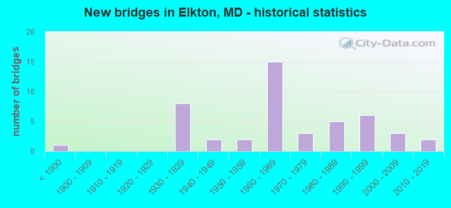
- New bridges - historical statistics
- 1Before 1900
- 81930-1939
- 21940-1949
- 21950-1959
- 151960-1969
- 31970-1979
- 51980-1989
- 61990-1999
- 32000-2009
- 22010-2019

- Reconstructed bridges - Historical Statistics
- 11960-1969
- 21970-1979
- 151980-1989
- 21990-1999
- 12000-2009


- Bridge Condition - Deck
- 2.4%Very good
- 45.2%Good
- 47.6%Satisfactory
- 2.4%Fair
- 2.4%Poor

- Bridge Condition - Superstructure
- 2.4%Excellent
- 4.8%Very good
- 28.6%Good
- 54.8%Satisfactory
- 7.1%Fair
- 2.4%Poor

- Bridge Condition - Substructure
- 4.8%Very good
- 38.1%Good
- 47.6%Satisfactory
- 9.5%Fair

- Bridge Condition - Channel
- 2.9%Very good
- 34.3%Good
- 48.6%Satisfactory
- 14.3%Fair

- Bridge Condition - Culverts
- 40.0%Good
- 40.0%Satisfactory
- 20.0%Fair
Find on map >> Show street view
Structure Number: 300000CEXA4701, Location: Milepost M104.7 (Lat: 39.642269, Lng: -75.874911), Route carried "on" structure: Interstate 95, Year Built: 1963, Year Reconstructed: 1986, Status: Open, Structure Length: 5.18m (16.99ft), Average Daily Traffic: 78,625 (year 2019), Truck Traffic: 12%, Average Future Daily Traffic: 110,286 (year 2041), Design Load: HS 20, Features Intersected: B&O RR
Minimum Vertical Clearance: 30+ m (98+ ft), Kilometerpoint: 168.462, Lanes on structure: 6, Base Highway Network: Yes, Toll: On toll road, Owner: State Toll Authority, Approaching Roadway Width: 45.1m (148.0ft), Skew: 33 degrees, Material/Design: Steel, Design/Construction: Stringer/Multi-beam, Number Of Spans In Main Unit: 3, Length of Maximum Span: 21.0m (68.9ft), Curb-To-Curb Width: 44.2m (145.0ft), Out-to-Out Width: 46.2m (151.6ft)
Condition: Deck: Fair, Superstructure: Satisfactory, Substructure: Fair, Operating Rating: 86.2 metric tons, Method Used To Determine Operating Rating: Load Factor (LF), Inventory Rating: 51.7 metric tons, Method Used To Determine Inventory Rating: Load Factor (LF), Structural Evaluation: Somewhat better than minimum adequacy, Deck Geometry: Superior to present desirable criteria, Underclear: Better than present minimum criteria, Approach Roadway Alignment: Equal to present desirable criteria, Designated Inspection Frequency: Every 24 months, Inspection Date: October 2021, Deck Structure Type: Concrete Cast-file-Place, Wearing Surface/Protective System: Wearing Surface: Latex Concrete, Deck Protection: Epoxy Coated Reinforcing
Find on map >> Show street view
Structure Number: 300000CEXA5101, Location: 4.4 MI S OF MD LINE (Lat: 39.641500, Lng: -75.867250), Route carried "on" structure: Interstate 95, Year Built: 1963, Year Reconstructed: 1986, Status: Open, Structure Length: 9.30m (30.51ft), Average Daily Traffic: 78,625 (year 2019), Truck Traffic: 12%, Average Future Daily Traffic: 110,286 (year 2041), Design Load: HS 20, Features Intersected: MD 545,LITTLE ELK CREEK
Minimum Vertical Clearance: 30+ m (98+ ft), Kilometerpoint: 169.106, Lanes on structure: 6, Lanes under structure: 2, Base Highway Network: Yes, Toll: On toll road, Owner: State Toll Authority, Approaching Roadway Width: 45.1m (148.0ft), Skew: 39 degrees, Material/Design: Steel, Design/Construction: Stringer/Multi-beam, Number Of Spans In Main Unit: 5, Length of Maximum Span: 28.7m (94.2ft), Curb-To-Curb Width: 44.2m (145.0ft), Out-to-Out Width: 46.2m (151.6ft)
Condition: Deck: Satisfactory, Superstructure: Satisfactory, Substructure: Good, Channel: Very good, Operating Rating: 84.8 metric tons, Method Used To Determine Operating Rating: Load Factor (LF), Inventory Rating: 50.8 metric tons, Method Used To Determine Inventory Rating: Load Factor (LF), Structural Evaluation: Equal to present minimum criteria, Deck Geometry: Superior to present desirable criteria, Underclear: Somewhat better than minimum adequacy, Waterway Adequacy: Equal to present desirable criteria, Approach Roadway Alignment: Equal to present desirable criteria, Designated Inspection Frequency: Every 24 months, Inspection Date: November 2021, Deck Structure Type: Concrete Cast-file-Place, Wearing Surface/Protective System: Wearing Surface: Latex Concrete, Membrane: Epoxy, Deck Protection: Epoxy Coated Reinforcing
Find on map >> Show street view
Structure Number: 300000CEXA6201, Location: Milepost M106.2 (Lat: 39.645881, Lng: -75.847061), Route carried "on" structure: State highway 213, Year Built: 1963, Status: Open, Structure Length: 7.13m (23.39ft), Average Daily Traffic: 9,031 (year 2019), Truck Traffic: 2%, Average Future Daily Traffic: 10,761 (year 2041), Design Load: HS 20, Features Intersected: I-95
Minimum Vertical Clearance: 30+ m (98+ ft), Kilometerpoint: 170.876, Lanes on structure: 2, Lanes under structure: 6, Owner: State Toll Authority, Approaching Roadway Width: 9.1m (29.9ft), Skew: 1 degrees, Material/Design: Steel, Design/Construction: Stringer/Multi-beam, Number Of Spans In Main Unit: 4, Length of Maximum Span: 24.1m (79.1ft), Curb or Sidewalk Widths: Left: 0.5m (1.6ft), Right: 0.5m (1.6ft), Curb-To-Curb Width: 9.1m (29.9ft), Out-to-Out Width: 10.7m (35.1ft)
Condition: Deck: Good, Superstructure: Satisfactory, Substructure: Satisfactory, Operating Rating: 68.0 metric tons, Method Used To Determine Operating Rating: Load Factor (LF), Inventory Rating: 40.8 metric tons, Method Used To Determine Inventory Rating: Load Factor (LF), Structural Evaluation: Equal to present minimum criteria, Deck Geometry: Meets minimum limits, Underclear: Meets minimum limits, Approach Roadway Alignment: Equal to present desirable criteria, Designated Inspection Frequency: Every 24 months, Inspection Date: October 2021, Deck Structure Type: Concrete Cast-file-Place, Wearing Surface/Protective System: Wearing Surface: Monolithic Concrete
Find on map >> Show street view
Structure Number: 300000CEXA7801, Location: 1.9 MI S OF MD LINE (Lat: 39.642469, Lng: -75.822731), Route carried "on" structure: Interstate 95, Year Built: 1963, Year Reconstructed: 1985, Status: Open, Structure Length: 4.88m (16.01ft), Average Daily Traffic: 78,625 (year 2019), Truck Traffic: 12%, Average Future Daily Traffic: 110,286 (year 2041), Design Load: HS 20, Features Intersected: BIG ELK CREEK
Minimum Vertical Clearance: 30+ m (98+ ft), Kilometerpoint: 173.450, Lanes on structure: 6, Base Highway Network: Yes, Toll: On toll road, Owner: State Toll Authority, Approaching Roadway Width: 45.1m (148.0ft), Skew: 30 degrees, Material/Design: Steel, Design/Construction: Stringer/Multi-beam, Number Of Spans In Main Unit: 3, Length of Maximum Span: 23.8m (78.1ft), Curb-To-Curb Width: 44.2m (145.0ft), Out-to-Out Width: 46.7m (153.2ft)
Condition: Deck: Good, Superstructure: Satisfactory, Substructure: Satisfactory, Channel: Good, Operating Rating: 85.3 metric tons, Method Used To Determine Operating Rating: Load Factor (LF), Inventory Rating: 51.2 metric tons, Method Used To Determine Inventory Rating: Load Factor (LF), Structural Evaluation: Equal to present minimum criteria, Deck Geometry: Superior to present desirable criteria, Waterway Adequacy: Equal to present desirable criteria, Approach Roadway Alignment: Equal to present desirable criteria, Designated Inspection Frequency: Every 24 months, Inspection Date: October 2021, Deck Structure Type: Concrete Cast-file-Place, Wearing Surface/Protective System: Wearing Surface: Monolithic Concrete
Find on map >> Show street view
Structure Number: 300000CEXA8301, Location: Milepost M108.3 (Lat: 39.642069, Lng: -75.812231), Route carried "on" structure: State highway 316, Year Built: 1963, Year Reconstructed: 1987, Status: Open, Structure Length: 6.98m (22.90ft), Average Daily Traffic: 5,326 (year 2019), Truck Traffic: 4%, Average Future Daily Traffic: 6,346 (year 2041), Design Load: HS 20, Features Intersected: I-95
Minimum Vertical Clearance: 30+ m (98+ ft), Kilometerpoint: 174.255, Lanes on structure: 2, Lanes under structure: 6, Owner: State Toll Authority, Approaching Roadway Width: 9.1m (29.9ft), Material/Design: Steel, Design/Construction: Stringer/Multi-beam, Number Of Spans In Main Unit: 4, Length of Maximum Span: 23.2m (76.1ft), Curb-To-Curb Width: 9.1m (29.9ft), Out-to-Out Width: 10.7m (35.1ft)
Condition: Deck: Good, Superstructure: Good, Substructure: Fair, Operating Rating: 73.5 metric tons, Method Used To Determine Operating Rating: Load Factor (LF), Inventory Rating: 44.0 metric tons, Method Used To Determine Inventory Rating: Load Factor (LF), Structural Evaluation: Somewhat better than minimum adequacy, Deck Geometry: Meets minimum limits, Underclear: High priority of corrective action, Approach Roadway Alignment: Equal to present desirable criteria, Designated Inspection Frequency: Every 24 months, Inspection Date: October 2021, Deck Structure Type: Concrete Cast-file-Place, Wearing Surface/Protective System: Wearing Surface: Monolithic Concrete
Find on map >> Show street view
Structure Number: 300000CEXA8901, Location: Milepost M108.9 (Lat: 39.640783, Lng: -75.802675), Route carried "on" structure: Interstate 95, Year Built: 1964, Year Reconstructed: 1971, Status: Open, Structure Length: 7.65m (25.10ft), Average Daily Traffic: 74,335 (year 2019), Truck Traffic: 27%, Average Future Daily Traffic: 104,268 (year 2041), Design Load: HS 20, Features Intersected: MD 279
Minimum Vertical Clearance: 30+ m (98+ ft), Kilometerpoint: 175.220, Lanes on structure: 10, Lanes under structure: 6, Base Highway Network: Yes, Toll: On toll road, Owner: State Toll Authority, Approaching Roadway Width: 45.1m (148.0ft), Skew: 32 degrees, Material/Design: Steel, Design/Construction: Stringer/Multi-beam, Number Of Spans In Main Unit: 4, Length of Maximum Span: 25.0m (82.0ft), Curb-To-Curb Width: 44.2m (145.0ft), Out-to-Out Width: 46.2m (151.6ft)
Condition: Deck: Satisfactory, Superstructure: Satisfactory, Substructure: Good, Operating Rating: 71.7 metric tons, Method Used To Determine Operating Rating: Load Factor (LF), Inventory Rating: 42.6 metric tons, Method Used To Determine Inventory Rating: Load Factor (LF), Structural Evaluation: Equal to present minimum criteria, Deck Geometry: Better than present minimum criteria, Underclear: Meets minimum limits, Approach Roadway Alignment: Equal to present desirable criteria, Designated Inspection Frequency: Every 24 months, Inspection Date: January 2020, Deck Structure Type: Concrete Cast-file-Place, Wearing Surface/Protective System: Wearing Surface: Monolithic Concrete, Membrane: Epoxy, Deck Protection: Epoxy Coated Reinforcing
Find on map >> Show street view
Structure Number: 300000CEXA9201, Location: Milepost M109.2 (Lat: 39.639931, Lng: -75.797581), Route carried "on" structure: Interstate 95, Year Built: 1962, Year Reconstructed: 1988, Status: Open, Structure Length: 5.49m (18.01ft), Average Daily Traffic: 64,281 (year 2019), Truck Traffic: 11%, Average Future Daily Traffic: 90,166 (year 2041), Design Load: HS 20, Features Intersected: AMTRAK RR
Minimum Vertical Clearance: 30+ m (98+ ft), Kilometerpoint: 175.703, Lanes on structure: 8, Base Highway Network: Yes, Toll: On toll road, Owner: State Toll Authority, Approaching Roadway Width: 52.4m (171.9ft), Skew: 32 degrees, Material/Design: Steel, Design/Construction: Stringer/Multi-beam, Number Of Spans In Main Unit: 3, Length of Maximum Span: 25.9m (85.0ft), Curb-To-Curb Width: 51.5m (169.0ft), Out-to-Out Width: 53.5m (175.5ft)
Condition: Deck: Satisfactory, Superstructure: Satisfactory, Substructure: Good, Operating Rating: 76.6 metric tons, Method Used To Determine Operating Rating: Load Factor (LF), Inventory Rating: 45.8 metric tons, Method Used To Determine Inventory Rating: Load Factor (LF), Structural Evaluation: Equal to present minimum criteria, Deck Geometry: Superior to present desirable criteria, Underclear: Equal to present minimum criteria, Approach Roadway Alignment: Equal to present desirable criteria, Designated Inspection Frequency: Every 24 months, Inspection Date: October 2021, Deck Structure Type: Concrete Cast-file-Place, Wearing Surface/Protective System: Wearing Surface: Monolithic Concrete