Bridge Statistics for Ellery, New York (NY)
Condition, Traffic, Stress, Structural Evaluation, Project Costs
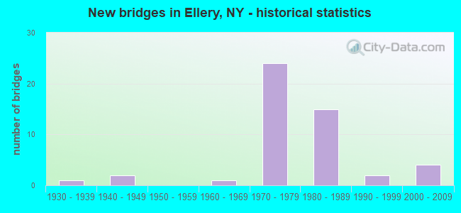
- New bridges - historical statistics
- 11930-1939
- 21940-1949
- 11960-1969
- 241970-1979
- 151980-1989
- 21990-1999
- 42000-2009


- Bridge Condition - Deck
- 3.0%Very good
- 51.5%Good
- 33.3%Satisfactory
- 9.1%Fair
- 3.0%Poor

- Bridge Condition - Superstructure
- 18.2%Very good
- 45.5%Good
- 24.2%Satisfactory
- 9.1%Fair
- 3.0%Poor

- Bridge Condition - Substructure
- 18.2%Very good
- 42.4%Good
- 30.3%Satisfactory
- 6.1%Fair
- 3.0%Poor

- Bridge Condition - Channel
- 20.0%Very good
- 32.0%Good
- 32.0%Satisfactory
- 12.0%Fair
- 4.0%Poor

- Bridge Condition - Culverts
- 50.0%Good
- 50.0%Satisfactory
Find on map >> Show street view
Structure Number: 109188, Location: 1.7 MI SE OF BEMUS POINT (Lat: 42.145314, Lng: -79.360806), Route carried "under" structure: Interstate 86, Year Built: 1976, Structure Length: 0. m, Average Daily Traffic: 7,057 (year 2018), Truck Traffic: 18%, Features Intersected: RTE I86
Minimum Vertical Clearance: 6.76m (22.18ft), Kilometerpoint: 34.513, Lanes on structure: 2, Lanes under structure: 2, Material/Design: Steel, Design/Construction: Stringer/Multi-beam, Length of Maximum Span: 40.5m (132.9ft)
Find on map >> Show street view
Structure Number: 109189, Location: 1.7 MI SE OF BEMUS POINT (Lat: 42.146653, Lng: -79.361072), Route carried "under" structure: Other road , Year Built: 1976, Structure Length: 0. m, Average Daily Traffic: 290 (year 2016), Truck Traffic: 2%, Features Intersected: WESTMAN ROAD, Facility Carried by Structure: RTE I86
Minimum Vertical Clearance: 6.02m (19.75ft), Kilometerpoint: 0.965, Lanes on structure: 2, Lanes under structure: 2, Material/Design: Steel, Design/Construction: Stringer/Multi-beam, Length of Maximum Span: 42.3m (138.8ft)
Find on map >> Show street view
Structure Number: 1091901, Location: 2.7 MI SE BEMUS POINT (Lat: 42.137933, Lng: -79.345211), Route carried "under" structure: Other road , Year Built: 1976, Structure Length: 0. m, Average Daily Traffic: 95 (year 2016), Features Intersected: BELLVIEW ROAD, Facility Carried by Structure: RTE I86
Minimum Vertical Clearance: 15.29m (50.16ft), Kilometerpoint: 1.030, Lanes on structure: 2, Lanes under structure: 2, Material/Design: Steel, Design/Construction: Stringer/Multi-beam, Length of Maximum Span: 35.0m (114.8ft)
Find on map >> Show street view
Structure Number: 1091902, Location: 2.7 MI SE BEMUS POINT (Lat: 42.137553, Lng: -79.345067), Route carried "under" structure: Other road , Year Built: 1976, Structure Length: 0. m, Average Daily Traffic: 95 (year 2016), Features Intersected: BELLVIEW ROAD, Facility Carried by Structure: RTE I86
Minimum Vertical Clearance: 15.72m (51.57ft), Kilometerpoint: 1.014, Lanes on structure: 2, Lanes under structure: 2, Material/Design: Steel, Design/Construction: Stringer/Multi-beam, Length of Maximum Span: 35.0m (114.8ft)
Find on map >> Show street view
Structure Number: 1091911, Location: 3.5MI W.INTERS RT 60 & 17 (Lat: 42.128389, Lng: -79.310389), Route carried "under" structure: County highway , Year Built: 1976, Structure Length: 0. m, Average Daily Traffic: 722 (year 2020), Truck Traffic: 4%, Features Intersected: DUTCH HOL RD/CR57, DUTCH, Facility Carried by Structure: RTE I86
Minimum Vertical Clearance: 19.99m (65.58ft), Kilometerpoint: 0.660, Lanes on structure: 2, Lanes under structure: 2, Material/Design: Steel continuous, Design/Construction: Stringer/Multi-beam, Length of Maximum Span: 43.5m (142.7ft)
Find on map >> Show street view
Structure Number: 1091912, Location: 3.5MI W.INTERS RT 60 & 17 (Lat: 42.128053, Lng: -79.310133), Route carried "under" structure: County highway , Year Built: 1976, Structure Length: 0. m, Average Daily Traffic: 722 (year 2020), Truck Traffic: 4%, Features Intersected: DUTCH HOL RD/CR57, DUTCH, Facility Carried by Structure: RTE I86
Minimum Vertical Clearance: 18.34m (60.17ft), Kilometerpoint: 0.579, Lanes on structure: 2, Lanes under structure: 2, Material/Design: Steel continuous, Design/Construction: Stringer/Multi-beam, Length of Maximum Span: 43.5m (142.7ft)
Find on map >> Show street view
Structure Number: 1091921, Location: 0.6 MI NE GREENHURST (Lat: 42.128283, Lng: -79.295128), Route carried "under" structure: County highway , Year Built: 1976, Structure Length: 0. m, Average Daily Traffic: 383 (year 2020), Truck Traffic: 7%, Features Intersected: TOWN LNE RD CR59, Facility Carried by Structure: RTE I86
Minimum Vertical Clearance: 4.67m (15.32ft), Kilometerpoint: 0.772, Lanes on structure: 2, Lanes under structure: 2, Material/Design: Steel, Design/Construction: Stringer/Multi-beam, Length of Maximum Span: 27.1m (88.9ft)
Find on map >> Show street view
Structure Number: 1091922, Location: .6 MI NE OF GREENHURST (Lat: 42.127922, Lng: -79.295125), Route carried "under" structure: County highway , Year Built: 1976, Structure Length: 0. m, Average Daily Traffic: 383 (year 2020), Truck Traffic: 7%, Features Intersected: TOWN LNE RD CR59, Facility Carried by Structure: RTE I86
Minimum Vertical Clearance: 4.60m (15.09ft), Kilometerpoint: 0.660, Lanes on structure: 2, Lanes under structure: 2, Material/Design: Steel, Design/Construction: Stringer/Multi-beam, Length of Maximum Span: 27.1m (88.9ft)