Bridge Statistics for Fairfield, Iowa (IA)
Condition, Traffic, Stress, Structural Evaluation, Project Costs
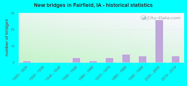
- New bridges - historical statistics
- 11920-1929
- 31950-1959
- 11960-1969
- 31970-1979
- 51980-1989
- 41990-1999
- 262000-2009
- 42010-2019

- Reconstructed bridges - Historical Statistics
- 21970-1979
- 01980-1989
- 01990-1999
- 12000-2009


- Bridge Condition - Deck
- 7.7%Very good
- 61.5%Good
- 23.1%Satisfactory
- 7.7%Serious

- Bridge Condition - Superstructure
- 57.7%Very good
- 19.2%Good
- 15.4%Satisfactory
- 3.8%Poor
- 3.8%Serious

- Bridge Condition - Substructure
- 50.0%Very good
- 26.9%Good
- 11.5%Satisfactory
- 7.7%Fair
- 3.8%Serious

- Bridge Condition - Channel
- 16.7%Very good
- 43.3%Good
- 33.3%Satisfactory
- 6.7%Fair

- Bridge Condition - Culverts
- 35.7%Very good
- 28.6%Good
- 35.7%Satisfactory
Find on map >> Show street view
Structure Number: 609875, Location: At the Jct. Iowa 1 (Lat: 40.983894, Lng: -91.962761), Route carried "under" structure: State highway 1, Year Built: 2007, Structure Length: 0. m, Average Daily Traffic: 4,000 (year 2020), Truck Traffic: 4%, Features Intersected: IA 1, Facility Carried by Structure: US 34 WB
Minimum Vertical Clearance: 30+ m (98+ ft), Kilometerpoint: 37.023, Lanes on structure: 3, Lanes under structure: 2, Material/Design: Prestressed concrete, Design/Construction: Stringer/Multi-beam, Length of Maximum Span: 32.3m (106.0ft)
Find on map >> Show street view
Structure Number: 6099, Location: 3.0 mi. E of Jct. IA #1 (Lat: 41.000864, Lng: -91.914247), Route carried "under" structure: US 34, Year Built: 2007, Structure Length: 0. m, Average Daily Traffic: 4,630 (year 2020), Truck Traffic: 30%, Features Intersected: RELOC US 34, Facility Carried by Structure: OSAGE AVE
Minimum Vertical Clearance: 30+ m (98+ ft), Kilometerpoint: 350.151, Lanes on structure: 2, Lanes under structure: 4, Material/Design: Prestressed concrete, Design/Construction: Stringer/Multi-beam, Length of Maximum Span: 39.9m (130.9ft)