Bridge Statistics for Farmers Branch, Texas (TX)
Condition, Traffic, Stress, Structural Evaluation, Project Costs
- National Bridge Inventory (NBI) Statistics
- 113Number of bridges
- 4,255ft / 1,297mTotal length
- $428,000Total costs
- 3,403,498Total average daily traffic
- 281,855Total average daily truck traffic
- National Bridge Inventory (NBI) Registered Bridges for Farmers Branch
- No street view available for this location
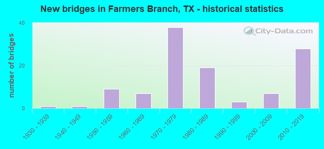
- New bridges - historical statistics
- 11930-1939
- 11940-1949
- 91950-1959
- 71960-1969
- 381970-1979
- 191980-1989
- 31990-1999
- 72000-2009
- 282010-2019

- Reconstructed bridges - Historical Statistics
- 51970-1979
- 61980-1989
- 11990-1999
- 62000-2009
- 32010-2019
- 12020-2022


- Bridge Condition - Deck
- 9.5%Very good
- 60.3%Good
- 30.2%Satisfactory

- Bridge Condition - Superstructure
- 23.8%Very good
- 50.8%Good
- 25.4%Satisfactory

- Bridge Condition - Substructure
- 3.2%Very good
- 63.5%Good
- 33.3%Satisfactory

- Bridge Condition - Channel
- 7.4%Very good
- 58.8%Good
- 26.5%Satisfactory
- 7.4%Fair

- Bridge Condition - Culverts
- 34.6%Good
- 61.5%Satisfactory
- 3.8%Fair
Find on map >> Show street view
Structure Number: 180570G0115501, Location: 0.15 MI N OF LBJ FRWY (Lat: 32.915736, Lng: -96.935108), Route carried "on" structure: City street , Year Built: 1984, Status: Open, Structure Length: 42.76m (140.29ft), Average Daily Traffic: 18,238 (year 2015), Truck Traffic: 3%, Average Future Daily Traffic: 25,533 (year 2037), Design Load: HS 20, Features Intersected: ELM FORK TRINITY RIVER, Facility Carried by Structure: VALLEY VIEW LN WB
Minimum Vertical Clearance: 30+ m (98+ ft), Kilometerpoint: 1.931, Lanes on structure: 2, Owner: City or Municipal Highway Agency, Approaching Roadway Width: 11.6m (38.1ft), Material/Design: Prestressed concrete, Design/Construction: Box Beam or Girders - Multiple, Number Of Spans In Main Unit: 2, Number Of Approach Spans: 30, Length of Maximum Span: 30.5m (100.1ft), Curb-To-Curb Width: 11.6m (38.1ft), Out-to-Out Width: 12.2m (40.0ft)
Condition: Deck: Satisfactory, Superstructure: Satisfactory, Substructure: Satisfactory, Channel: Satisfactory, Operating Rating: 54.4 metric tons, Method Used To Determine Operating Rating: Assigned rating based on Load Factor Design (LFD) reported in metric tons, Inventory Rating: 32.7 metric tons, Method Used To Determine Inventory Rating: Assigned rating based on Load Factor Design (LFD) reported in metric tons, Structural Evaluation: Equal to present minimum criteria, Deck Geometry: Better than present minimum criteria, Waterway Adequacy: Superior to present desirable criteria, Approach Roadway Alignment: Equal to present desirable criteria, Designated Inspection Frequency: Every 24 months, Inspection Date: January 2021, Deck Structure Type: Concrete Cast-file-Place
Find on map >> Show street view
Structure Number: 180570G01155011, Location: O.15 MI N OF LBJ FRWY (Lat: 32.915706, Lng: -96.935067), Route carried "on" structure: City street , Year Built: 1984, Status: Open, Structure Length: 42.76m (140.29ft), Average Daily Traffic: 18,238 (year 2015), Truck Traffic: 3%, Average Future Daily Traffic: 25,533 (year 2037), Design Load: HS 20, Features Intersected: ELM FORK TRINITY RIVER, Facility Carried by Structure: VALLEY VIEW LN EB
Minimum Vertical Clearance: 30+ m (98+ ft), Kilometerpoint: 1.931, Lanes on structure: 2, Owner: City or Municipal Highway Agency, Approaching Roadway Width: 11.6m (38.1ft), Material/Design: Prestressed concrete, Design/Construction: Box Beam or Girders - Multiple, Number Of Spans In Main Unit: 2, Number Of Approach Spans: 30, Length of Maximum Span: 30.5m (100.1ft), Curb-To-Curb Width: 11.6m (38.1ft), Out-to-Out Width: 12.2m (40.0ft)
Condition: Deck: Satisfactory, Superstructure: Satisfactory, Substructure: Satisfactory, Channel: Fair, Operating Rating: 54.4 metric tons, Method Used To Determine Operating Rating: Assigned rating based on Load Factor Design (LFD) reported in metric tons, Inventory Rating: 32.7 metric tons, Method Used To Determine Inventory Rating: Assigned rating based on Load Factor Design (LFD) reported in metric tons, Structural Evaluation: Equal to present minimum criteria, Deck Geometry: Better than present minimum criteria, Waterway Adequacy: Superior to present desirable criteria, Approach Roadway Alignment: Equal to present desirable criteria, Designated Inspection Frequency: Every 24 months, Inspection Date: January 2021, Deck Structure Type: Concrete Cast-file-Place
Find on map >> Show street view
Structure Number: 180570G01170001, Location: 0.1 MI W OF JOSEY LANE (Lat: 32.938358, Lng: -96.891897), Route carried "on" structure: City street , Year Built: 1986, Status: Open, Structure Length: 1.46m (4.79ft), Average Daily Traffic: 17,000 (year 2015), Truck Traffic: 3%, Average Future Daily Traffic: 23,800 (year 2037), Features Intersected: COOKS BRANCH, Facility Carried by Structure: VALWOOD PARKWAY
Minimum Vertical Clearance: 30+ m (98+ ft), Kilometerpoint: 11.282, Lanes on structure: 4, Owner: City or Municipal Highway Agency, Approaching Roadway Width: 18.3m (60.0ft), Skew: 21 degrees, Material/Design: Prestressed concrete, Design/Construction: Box Beam or Girders - Multiple, Number Of Spans In Main Unit: 1, Length of Maximum Span: 14.0m (45.9ft), Curb or Sidewalk Widths: Left: 3.3m (10.8ft), Right: 3.3m (10.8ft), Curb-To-Curb Width: 18.3m (60.0ft), Out-to-Out Width: 29.9m (98.1ft)
Condition: Deck: Good, Superstructure: Good, Substructure: Good, Channel: Good, Operating Rating: 32.7 metric tons, Method Used To Determine Operating Rating: Field evaluation and documented engineering judgment, Inventory Rating: 24.5 metric tons, Method Used To Determine Inventory Rating: Field evaluation and documented engineering judgment, Structural Evaluation: Equal to present minimum criteria, Deck Geometry: Somewhat better than minimum adequacy, Waterway Adequacy: Better than present minimum criteria, Approach Roadway Alignment: Equal to present desirable criteria, Designated Inspection Frequency: Every 24 months, Inspection Date: April 2021, Deck Structure Type: Concrete Cast-file-Place
Find on map >> Show street view
Structure Number: 180570G01185001, Location: 0.3 MI W OF WEBB CHAPEL (Lat: 32.917428, Lng: -96.877975), Route carried "on" structure: City street , Year Built: 1991, Status: Open, Structure Length: 1.28m (4.20ft), Average Daily Traffic: 502 (year 2015), Truck Traffic: 3%, Average Future Daily Traffic: 702 (year 2037), Features Intersected: FARMERS BRANCH, Facility Carried by Structure: VERONICA RD
Minimum Vertical Clearance: 30+ m (98+ ft), Kilometerpoint: 0.740, Lanes on structure: 2, Owner: City or Municipal Highway Agency, Approaching Roadway Width: 7.9m (25.9ft), Material/Design: Concrete, Design/Construction: Frame, Number Of Spans In Main Unit: 1, Length of Maximum Span: 12.2m (40.0ft), Curb or Sidewalk Widths: Left: 1.2m (3.9ft), Right: 1.2m (3.9ft), Curb-To-Curb Width: 7.8m (25.6ft), Out-to-Out Width: 12.2m (40.0ft)
Condition: Deck: Good, Superstructure: Good, Substructure: Good, Channel: Good, Operating Rating: 32.7 metric tons, Method Used To Determine Operating Rating: Field evaluation and documented engineering judgment, Inventory Rating: 24.5 metric tons, Method Used To Determine Inventory Rating: Field evaluation and documented engineering judgment, Structural Evaluation: Equal to present minimum criteria, Deck Geometry: Meets minimum limits, Waterway Adequacy: Better than present minimum criteria, Approach Roadway Alignment: Equal to present desirable criteria, Designated Inspection Frequency: Every 24 months, Inspection Date: April 2021, Deck Structure Type: Concrete Cast-file-Place
Find on map >> Show street view
Structure Number: 180570G01215005, Location: 0.4 MI N OF IH 635 (Lat: 32.918400, Lng: -96.873147), Route carried "on" structure: City street , Year Built: 1970, Status: Open, Structure Length: 2.87m (9.42ft), Average Daily Traffic: 7,060 (year 2015), Truck Traffic: 3%, Average Future Daily Traffic: 9,888 (year 2037), Features Intersected: FARMERS BRANCH, Facility Carried by Structure: WEBB CHAPEL RD NB
Minimum Vertical Clearance: 30+ m (98+ ft), Kilometerpoint: 2.253, Lanes on structure: 3, Owner: City or Municipal Highway Agency, Approaching Roadway Width: 10.1m (33.1ft), Skew: 1 degrees, Material/Design: Concrete, Design/Construction: Stringer/Multi-beam, Number Of Spans In Main Unit: 3, Length of Maximum Span: 9.4m (30.8ft), Curb or Sidewalk Widths: Left: 0.5m (1.6ft), Right: 1.4m (4.6ft), Curb-To-Curb Width: 10.1m (33.1ft), Out-to-Out Width: 12.4m (40.7ft)
Condition: Deck: Good, Superstructure: Good, Substructure: Good, Channel: Good, Operating Rating: 32.7 metric tons, Method Used To Determine Operating Rating: Field evaluation and documented engineering judgment, Inventory Rating: 24.5 metric tons, Method Used To Determine Inventory Rating: Field evaluation and documented engineering judgment, Structural Evaluation: Equal to present minimum criteria, Deck Geometry: High priority of replacement, Waterway Adequacy: Better than present minimum criteria, Approach Roadway Alignment: Equal to present desirable criteria, Length Of Structure Improvement: 2.87m (9.42ft), Designated Inspection Frequency: Every 24 months, Inspection Date: April 2021, Bridge Improvement Cost: $6,000, Roadway Improvement Cost: $2,000, Total Project Cost: $8,000, Deck Structure Type: Concrete Cast-file-Place, Wearing Surface/Protective System: Wearing Surface: Bituminous
Find on map >> Show street view
Structure Number: 180570G01215006, Location: 0.4 MI N OF IH 635 (Lat: 32.918389, Lng: -96.873183), Route carried "on" structure: City street , Year Built: 1970, Status: Open, Structure Length: 2.87m (9.42ft), Average Daily Traffic: 7,060 (year 2017), Truck Traffic: 3%, Average Future Daily Traffic: 9,888 (year 2037), Features Intersected: FARMERS BRANCH, Facility Carried by Structure: WEBB CHAPEL RD SB
Minimum Vertical Clearance: 30+ m (98+ ft), Kilometerpoint: 2.253, Lanes on structure: 3, Owner: City or Municipal Highway Agency, Approaching Roadway Width: 10.1m (33.1ft), Skew: 1 degrees, Material/Design: Concrete, Design/Construction: Stringer/Multi-beam, Number Of Spans In Main Unit: 3, Length of Maximum Span: 9.4m (30.8ft), Curb or Sidewalk Widths: Left: 1.4m (4.6ft), Right: 0.5m (1.6ft), Curb-To-Curb Width: 10.1m (33.1ft), Out-to-Out Width: 12.4m (40.7ft)
Condition: Deck: Good, Superstructure: Good, Substructure: Good, Channel: Satisfactory, Operating Rating: 32.7 metric tons, Method Used To Determine Operating Rating: Field evaluation and documented engineering judgment, Inventory Rating: 24.5 metric tons, Method Used To Determine Inventory Rating: Field evaluation and documented engineering judgment, Structural Evaluation: Equal to present minimum criteria, Deck Geometry: High priority of replacement, Waterway Adequacy: Better than present minimum criteria, Approach Roadway Alignment: Equal to present desirable criteria, Length Of Structure Improvement: 2.87m (9.42ft), Designated Inspection Frequency: Every 24 months, Inspection Date: April 2021, Bridge Improvement Cost: $6,000, Roadway Improvement Cost: $2,000, Total Project Cost: $8,000, Deck Structure Type: Concrete Cast-file-Place, Wearing Surface/Protective System: Wearing Surface: Bituminous
Find on map >> Show street view
Structure Number: 180570G01215007, Location: 0.2 MI N OF IH 635 (Lat: 32.915189, Lng: -96.873075), Route carried "on" structure: City street , Year Built: 1970, Status: Open, Structure Length: 0.91m (2.99ft), Average Daily Traffic: 14,119 (year 2015), Truck Traffic: 3%, Average Future Daily Traffic: 19,766 (year 2037), Features Intersected: DRAINAGE CHANNEL, Facility Carried by Structure: WEBB CHAPEL RD
Minimum Vertical Clearance: 30+ m (98+ ft), Kilometerpoint: 2.478, Lanes on structure: 7, Owner: City or Municipal Highway Agency, Approaching Roadway Width: 23.2m (76.1ft), Skew: 23 degrees, Material/Design: Concrete, Design/Construction: Culvert, Number Of Spans In Main Unit: 3, Length of Maximum Span: 2.4m (7.9ft), Curb or Sidewalk Widths: Left: 1.0m (3.3ft), Right: 1.3m (4.3ft)
Condition: Channel: Satisfactory, Culverts: Satisfactory, Operating Rating: 32.7 metric tons, Method Used To Determine Operating Rating: Field evaluation and documented engineering judgment, Inventory Rating: 24.5 metric tons, Method Used To Determine Inventory Rating: Field evaluation and documented engineering judgment, Structural Evaluation: Equal to present minimum criteria, Waterway Adequacy: Better than present minimum criteria, Approach Roadway Alignment: Equal to present desirable criteria, Designated Inspection Frequency: Every 24 months, Inspection Date: April 2021
Find on map >> Show street view
Structure Number: 180570G0121501, Location: 0.5 MI S OF VALWOOD PKWY (Lat: 32.934428, Lng: -96.873006), Route carried "on" structure: City street , Year Built: 1963, Year Reconstructed: 1970, Status: Open, Structure Length: 2.10m (6.89ft), Average Daily Traffic: 15,350 (year 2015), Truck Traffic: 3%, Average Future Daily Traffic: 21,490 (year 2037), Features Intersected: RAWHIDE CREEK, Facility Carried by Structure: WEBB CHAPEL ROAD
Minimum Vertical Clearance: 30+ m (98+ ft), Kilometerpoint: 3.782, Lanes on structure: 7, Owner: City or Municipal Highway Agency, Approaching Roadway Width: 20.1m (65.9ft), Skew: 23 degrees, Material/Design: Concrete, Design/Construction: Culvert, Number Of Spans In Main Unit: 6, Length of Maximum Span: 3.0m (9.8ft), Curb or Sidewalk Widths: Left: 1.2m (3.9ft), Right: 0.9m (3.0ft)
Condition: Channel: Good, Culverts: Satisfactory, Operating Rating: 32.7 metric tons, Method Used To Determine Operating Rating: Field evaluation and documented engineering judgment, Inventory Rating: 24.5 metric tons, Method Used To Determine Inventory Rating: Field evaluation and documented engineering judgment, Structural Evaluation: Equal to present minimum criteria, Waterway Adequacy: Equal to present minimum criteria, Approach Roadway Alignment: Equal to present desirable criteria, Designated Inspection Frequency: Every 24 months, Inspection Date: March 2021
Find on map >> Show street view
Structure Number: 180570G01220001, Location: 0.1 MI S OF SPRING VALLEY (Lat: 32.937975, Lng: -96.830567), Route carried "on" structure: City street , Year Built: 1996, Status: Open, Structure Length: 0.67m (2.20ft), Average Daily Traffic: 1,534 (year 2015), Truck Traffic: 3%, Average Future Daily Traffic: 2,147 (year 2037), Features Intersected: S BR OF FARMERS BR, Facility Carried by Structure: WELCH RD
Minimum Vertical Clearance: 30+ m (98+ ft), Kilometerpoint: 0.145, Lanes on structure: 4, Owner: City or Municipal Highway Agency, Approaching Roadway Width: 12.2m (40.0ft), Material/Design: Concrete, Design/Construction: Culvert, Number Of Spans In Main Unit: 2, Length of Maximum Span: 3.0m (9.8ft)
Condition: Channel: Good, Culverts: Satisfactory, Operating Rating: 32.7 metric tons, Method Used To Determine Operating Rating: Field evaluation and documented engineering judgment, Inventory Rating: 24.5 metric tons, Method Used To Determine Inventory Rating: Field evaluation and documented engineering judgment, Structural Evaluation: Equal to present minimum criteria, Waterway Adequacy: Better than present minimum criteria, Approach Roadway Alignment: Equal to present desirable criteria, Designated Inspection Frequency: Every 24 months, Inspection Date: April 2021
Find on map >> Show street view
Structure Number: 180570019602477, Location: 1.1 Mi N of IH 635 (Lat: 32.923014, Lng: -96.900297), Route carried "under" structure: City street , Year Built: 1957, Structure Length: 0. m, Average Daily Traffic: 8,749 (year 2013), Features Intersected: Valley View LN, Facility Carried by Structure: IH 35 E
Minimum Vertical Clearance: 4.44m (14.57ft), Kilometerpoint: 3.985, Lanes on structure: 8, Lanes under structure: 10, Material/Design: Steel continuous, Design/Construction: Stringer/Multi-beam, Length of Maximum Span: 17.4m (57.1ft)
Find on map >> Show street view
Structure Number: 18057001960307, Location: 2.2 Mi NW of IH 635 (Lat: 32.938283, Lng: -96.902322), Route carried "under" structure: City street , Year Built: 1957, Structure Length: 0. m, Average Daily Traffic: 1,487 (year 2013), Features Intersected: Valwood Pkwy, Facility Carried by Structure: IH 35E NB
Minimum Vertical Clearance: 4.47m (14.67ft), Kilometerpoint: 3.975, Lanes on structure: 4, Lanes under structure: 8, Material/Design: Steel continuous, Design/Construction: Stringer/Multi-beam, Length of Maximum Span: 21.3m (69.9ft)
Find on map >> Show street view
Structure Number: 180570019603071, Location: 2.2 Mi NW of IH 635 (Lat: 32.938814, Lng: -96.902792), Route carried "under" structure: City street , Year Built: 1957, Structure Length: 0. m, Average Daily Traffic: 1,487 (year 2013), Features Intersected: Valwood Pkwy, Facility Carried by Structure: IH 35E SB
Minimum Vertical Clearance: 4.95m (16.24ft), Kilometerpoint: 3.975, Lanes on structure: 4, Lanes under structure: 8, Material/Design: Steel continuous, Design/Construction: Stringer/Multi-beam, Length of Maximum Span: 21.3m (69.9ft)
Find on map >> Show street view
Structure Number: 180570019603075, Location: 1.1 Mi N of IH 635 (Lat: 32.922553, Lng: -96.899667), Route carried "under" structure: City street 35, Year Built: 1957, Structure Length: 0. m, Average Daily Traffic: 8,749 (year 2015), Features Intersected: Valley View Ln
Minimum Vertical Clearance: 4.40m (14.44ft), Kilometerpoint: 3.990, Lanes on structure: 3, Lanes under structure: 10, Material/Design: Steel continuous, Design/Construction: Stringer/Multi-beam, Length of Maximum Span: 17.4m (57.1ft)
Find on map >> Show street view
Structure Number: 180570019603187, Location: 0.8 Mi N of IH 635 (Lat: 32.918194, Lng: -96.899103), Route carried "under" structure: Ramp Interstate 35, Year Built: 1976, Structure Length: 0. m, Average Daily Traffic: 97,500 (year 2013), Truck Traffic: 7%, Features Intersected: IH 35E SB Off-Rp
Minimum Vertical Clearance: 5.05m (16.57ft), Kilometerpoint: 46.282, Lanes on structure: 1, Lanes under structure: 2, Material/Design: Steel continuous, Design/Construction: Stringer/Multi-beam, Length of Maximum Span: 32.3m (106.0ft)
Find on map >> Show street view
Structure Number: 180570019603366, Location: 3.2 Mi N of LP 12 (Lat: 32.916339, Lng: -96.899486), Route carried "under" structure: Interstate 635, Year Built: 1977, Structure Length: 0. m, Average Daily Traffic: 246,000 (year 2016), Truck Traffic: 11%, Features Intersected: IH 635 WB & Creek
Minimum Vertical Clearance: 5.03m (16.50ft), Kilometerpoint: 15.244, Lanes on structure: 1, Lanes under structure: 20, Material/Design: Steel continuous, Design/Construction: Stringer/Multi-beam, Length of Maximum Span: 50.0m (164.0ft)
Find on map >> Show street view
Structure Number: 180570019603464, Location: 0.56 MI S of Valley View (Lat: 32.907542, Lng: -96.898864), Route carried "under" structure: Interstate , Year Built: 2014, Structure Length: 0. m, Average Daily Traffic: 500 (year 2015), Truck Traffic: 10%, Features Intersected: IH 35ESB to IH 635EB, Facility Carried by Structure: IH35ESB to IH635EB
Minimum Vertical Clearance: 30+ m (98+ ft), Kilometerpoint: 0.000, Lanes on structure: 33, Material/Design: Steel, Design/Construction: Stringer/Multi-beam, Length of Maximum Span: 75.6m (248.0ft)
Find on map >> Show street view
Structure Number: 180570019603495, Location: 0.7 MI N of IH 635 (Lat: 32.918347, Lng: -96.898739), Route carried "under" structure: Interstate 35, Year Built: 2018, Structure Length: 0. m, Average Daily Traffic: 179,831 (year 2017), Truck Traffic: 11%, Features Intersected: IH35E SB HarryHines Crk
Minimum Vertical Clearance: 5.27m (17.29ft), Kilometerpoint: 45.316, Lanes on structure: 1, Lanes under structure: 9, Material/Design: Prestressed concrete, Design/Construction: Stringer/Multi-beam, Length of Maximum Span: 33.6m (110.2ft)
Find on map >> Show street view
Structure Number: 180570237401407, Location: 2.2 MI E OF MARSH LN (Lat: 32.926281, Lng: -96.821197), Route carried "under" structure: Other road 635, Year Built: 1985, Structure Length: 0. m, Average Daily Traffic: 246,000 (year 2011), Truck Traffic: 11%, Features Intersected: INWOOD RD SB, Facility Carried by Structure: INWOOD RD SB
Minimum Vertical Clearance: 5.41m (17.75ft), Kilometerpoint: 15.723, Lanes on structure: 18, Toll: On toll road, Material/Design: Steel continuous, Design/Construction: Stringer/Multi-beam, Length of Maximum Span: 48.2m (158.1ft)
Find on map >> Show street view
Structure Number: 18057023740152, Location: 1.65MI W OF DALLAS N TOLL (Lat: 32.921561, Lng: -96.848111), Route carried "under" structure: Interstate 635, Year Built: 2013, Structure Length: 0. m, Average Daily Traffic: 209,000 (year 2011), Truck Traffic: 10%, Features Intersected: Rosser Rd., Facility Carried by Structure: ROSSER RD
Minimum Vertical Clearance: 5.23m (17.16ft), Kilometerpoint: 0.000, Lanes on structure: 14, Lanes under structure: 7, Material/Design: Prestressed concrete, Design/Construction: Stringer/Multi-beam, Length of Maximum Span: 34.4m (112.9ft)
Find on map >> Show street view
Structure Number: 180570237401528, Location: 0.23 MI W of Josey Ln (Lat: 32.910492, Lng: -96.885189), Route carried "under" structure: Interstate 635, Year Built: 2014, Structure Length: 0. m, Average Daily Traffic: 500 (year 2015), Truck Traffic: 10%, Features Intersected: IH 635 MNGD WB-IH 35 RMP
Minimum Vertical Clearance: 30+ m (98+ ft), Kilometerpoint: 0.000, Lanes on structure: 4, Material/Design: Prestressed concrete, Design/Construction: Stringer/Multi-beam, Length of Maximum Span: 26.5m (86.9ft)
Find on map >> Show street view
Structure Number: 180570237401529, Location: 0.20 MI N of Harry Hines (Lat: 32.917114, Lng: -96.897431), Route carried "under" structure: Ramp Interstate 35, Year Built: 2014, Structure Length: 0. m, Average Daily Traffic: 500 (year 2015), Truck Traffic: 10%, Features Intersected: IH 35E NB EXIT RAMP
Minimum Vertical Clearance: 30+ m (98+ ft), Kilometerpoint: 0.000, Lanes on structure: 1, Material/Design: Prestressed concrete, Design/Construction: Stringer/Multi-beam, Length of Maximum Span: 32.0m (105.0ft)
Find on map >> Show street view
Structure Number: 180570237401533, Location: Valley View Lane @ IH 35E (Lat: 32.922767, Lng: -96.899561), Route carried "under" structure: City street , Year Built: 2014, Structure Length: 0. m, Average Daily Traffic: 500 (year 2015), Truck Traffic: 10%, Features Intersected: IH 35E NB ENT RAMP, Facility Carried by Structure: IH 35E NB Ent Ramp
Minimum Vertical Clearance: 30+ m (98+ ft), Kilometerpoint: 0.000, Lanes on structure: 10, Material/Design: Prestressed concrete, Design/Construction: Stringer/Multi-beam, Length of Maximum Span: 31.1m (102.0ft)
Find on map >> Show street view
Structure Number: 180570237401534, Location: 0.04 MI W of Midway Rd (Lat: 32.924497, Lng: -96.841483), Route carried "under" structure: City street , Year Built: 2014, Structure Length: 0. m, Average Daily Traffic: 500 (year 2015), Truck Traffic: 10%, Features Intersected: IH 635 WB EXIT RAMP, Facility Carried by Structure: IH 635 WB Exit Rmp
Minimum Vertical Clearance: 30+ m (98+ ft), Kilometerpoint: 0.000, Lanes on structure: 1, Material/Design: Prestressed concrete, Design/Construction: Stringer/Multi-beam, Length of Maximum Span: 36.6m (120.1ft)
Find on map >> Show street view
Structure Number: 180570237401535, Location: IH 635 @ Josey Lane (Lat: 32.914864, Lng: -96.881531), Route carried "under" structure: City street , Year Built: 2014, Structure Length: 0. m, Average Daily Traffic: 500 (year 2015), Truck Traffic: 10%, Features Intersected: IH 635 MNGD LNS ENT RAMP, Facility Carried by Structure: IH635W Mngd Ent Rp
Minimum Vertical Clearance: 30+ m (98+ ft), Kilometerpoint: 0.000, Lanes on structure: 10, Material/Design: Prestressed concrete, Design/Construction: Stringer/Multi-beam, Length of Maximum Span: 37.5m (123.0ft)
Find on map >> Show street view
Structure Number: 180570237401536, Location: 1 Mi East of IH-35E (Lat: 32.911683, Lng: -96.881878), Route carried "under" structure: City street , Year Built: 2013, Structure Length: 0. m, Average Daily Traffic: 99,999 (year 2013), Truck Traffic: 10%, Features Intersected: IH 635 WBFR EXIT RAMP, Facility Carried by Structure: IH635 WBFR/OFF RMP
Minimum Vertical Clearance: 5.97m (19.59ft), Kilometerpoint: 0.000, Lanes on structure: 10, Material/Design: Prestressed concrete, Design/Construction: Stringer/Multi-beam, Length of Maximum Span: 38.1m (125.0ft)
Find on map >> Show street view
Structure Number: 180570237401547, Location: 1.5 Mi E of IH-35E (Lat: 32.913381, Lng: -96.873269), Route carried "under" structure: City street , Year Built: 2013, Structure Length: 0. m, Average Daily Traffic: 9,999 (year 2013), Truck Traffic: 10%, Features Intersected: IH 635 WBFR, Facility Carried by Structure: IH 635 WBFR
Minimum Vertical Clearance: 5.59m (18.34ft), Kilometerpoint: 0.000, Lanes on structure: 10, Lanes under structure: 10, Material/Design: Prestressed concrete, Design/Construction: Stringer/Multi-beam, Length of Maximum Span: 38.4m (126.0ft)
Find on map >> Show street view
Structure Number: 180570237401552, Location: 1.3 MI W OF DALLAS N TOLL (Lat: 32.924597, Lng: -96.841586), Route carried "under" structure: City street , Year Built: 2013, Structure Length: 0. m, Average Daily Traffic: 9,999 (year 2013), Truck Traffic: 10%, Features Intersected: IH 635 WBFR, Facility Carried by Structure: IH635 WBFR
Minimum Vertical Clearance: 5.03m (16.50ft), Kilometerpoint: 7.133, Lanes on structure: 2, Material/Design: Prestressed concrete, Design/Construction: Stringer/Multi-beam, Length of Maximum Span: 16.2m (53.1ft)
Find on map >> Show street view
Structure Number: 18057023740156, Location: 0.15 MI W of Josey Ln (Lat: 32.909453, Lng: -96.892636), Route carried "under" structure: City street , Year Built: 2014, Structure Length: 0. m, Average Daily Traffic: 500 (year 2015), Truck Traffic: 10%, Features Intersected: IH 635 WB to IH 35E NB, Facility Carried by Structure: IH635MgdWB IH35ENB
Minimum Vertical Clearance: 30+ m (98+ ft), Kilometerpoint: 0.000, Lanes on structure: 19, Material/Design: Prestressed concrete, Design/Construction: Stringer/Multi-beam, Length of Maximum Span: 39.0m (128.0ft)
Find on map >> Show street view
Structure Number: 180570237401605, Location: 0.3 MI SW of Rosser Rd (Lat: 32.919044, Lng: -96.854286), Route carried "under" structure: Other road 635, Year Built: 2014, Structure Length: 0. m, Average Daily Traffic: 500 (year 2015), Truck Traffic: 10%, Features Intersected: IH 635 WBML
Minimum Vertical Clearance: 30+ m (98+ ft), Kilometerpoint: 0.000, Lanes on structure: 3, Toll: On toll road, Material/Design: Prestressed concrete, Design/Construction: Stringer/Multi-beam, Length of Maximum Span: 40.2m (131.9ft)
Find on map >> Show street view
Structure Number: 180570237407372, Location: 2.0 MI W OF IH 35E (Lat: 32.910903, Lng: -96.935403), Route carried "under" structure: ServiceCity street , Year Built: 1976, Structure Length: 0. m, Average Daily Traffic: 850 (year 2011), Features Intersected: IH 635 WB, Facility Carried by Structure: IH 635 WB
Minimum Vertical Clearance: 4.60m (15.09ft), Kilometerpoint: 3.816, Lanes on structure: 3, Lanes under structure: 2, Material/Design: Prestressed concrete, Design/Construction: Stringer/Multi-beam, Length of Maximum Span: 38.1m (125.0ft)
Find on map >> Show street view
Structure Number: 180570237407381, Location: 1.4 MI W OF IH 35E (Lat: 32.907914, Lng: -96.921406), Route carried "under" structure: City street , Year Built: 1979, Structure Length: 0. m, Average Daily Traffic: 15,014 (year 2019), Truck Traffic: 3%, Features Intersected: IH 635 WB, Facility Carried by Structure: IH 635 WB
Minimum Vertical Clearance: 5.23m (17.16ft), Kilometerpoint: 47.059, Lanes on structure: 5, Lanes under structure: 7, Material/Design: Prestressed concrete, Design/Construction: Stringer/Multi-beam, Length of Maximum Span: 21.9m (71.9ft)
Find on map >> Show street view
Structure Number: 180570237407382, Location: 1.4 MI W OF IH 35E (Lat: 32.907914, Lng: -96.921406), Route carried "under" structure: City street , Year Built: 1979, Structure Length: 0. m, Average Daily Traffic: 18,803 (year 2019), Truck Traffic: 34%, Features Intersected: IH 635 EB, Facility Carried by Structure: IH 635 EB
Minimum Vertical Clearance: 5.13m (16.83ft), Kilometerpoint: 47.059, Lanes on structure: 6, Material/Design: Prestressed concrete, Design/Construction: Stringer/Multi-beam, Length of Maximum Span: 21.9m (71.9ft)
Find on map >> Show street view
Structure Number: 18057023740745, Location: AT INT IH 635 AND PGBT (Lat: 32.911725, Lng: -96.944017), Route carried "under" structure: Interstate 635, Year Built: 2005, Structure Length: 0. m, Average Daily Traffic: 115,023 (year 2020), Truck Traffic: 8%, Features Intersected: PGBT SB, Facility Carried by Structure: PGBT SB
Minimum Vertical Clearance: 9.14m (29.99ft), Kilometerpoint: 30.164, Lanes on structure: 24, Material/Design: Steel continuous, Design/Construction: Stringer/Multi-beam, Length of Maximum Span: 50.9m (167.0ft)