Bridge Statistics for Florence, Kentucky (KY)
Condition, Traffic, Stress, Structural Evaluation, Project Costs
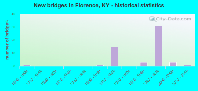
- New bridges - historical statistics
- 11900-1909
- 11950-1959
- 151960-1969
- 31980-1989
- 311990-1999
- 32000-2009
- 12010-2019


- Bridge Condition - Deck
- 56.0%Good
- 36.0%Satisfactory
- 8.0%Fair

- Bridge Condition - Superstructure
- 8.0%Very good
- 64.0%Good
- 16.0%Satisfactory
- 12.0%Fair

- Bridge Condition - Substructure
- 68.0%Good
- 20.0%Satisfactory
- 12.0%Fair

- Bridge Condition - Channel
- 18.8%Very good
- 43.8%Good
- 31.3%Satisfactory
- 6.3%Fair

- Bridge Condition - Culverts
- 14.3%Very good
- 57.1%Good
- 28.6%Satisfactory
Find on map >> Show street view
Structure Number: 8B00005L, Location: SBL 1 MI SW OF JCT US 25 (Lat: 38.985278, Lng: -84.641667), Route carried "on" structure: US 42, Year Built: 1960, Status: Posted for load, Structure Length: 9.97m (32.71ft), Average Daily Traffic: 11,448 (year 2020), Truck Traffic: 3%, Average Future Daily Traffic: 10,647 (year 2040), Design Load: HS 20, Features Intersected: I 71; I 75
Minimum Vertical Clearance: 30+ m (98+ ft), Kilometerpoint: 22.706, Lanes on structure: 2, Lanes under structure: 10, Owner: State Highway Agency, Approaching Roadway Width: 11.0m (36.1ft), Skew: 13 degrees, Material/Design: Concrete continuous, Design/Construction: Tee Beam, Number Of Spans In Main Unit: 4, Length of Maximum Span: 31.1m (102.0ft), Curb or Sidewalk Widths: Left: 0.8m (2.6ft), Right: 0.8m (2.6ft), Curb-To-Curb Width: 9.1m (29.9ft), Out-to-Out Width: 11.4m (37.4ft)
Condition: Deck: Fair, Superstructure: Fair, Substructure: Satisfactory, Operating Rating: 32.7 metric tons, Method Used To Determine Operating Rating: Load Factor (LF), Inventory Rating: 19.6 metric tons, Method Used To Determine Inventory Rating: Load Factor (LF), Structural Evaluation: Meets minimum limits, Deck Geometry: Meets minimum limits, Underclear: Meets minimum limits, Approach Roadway Alignment: Equal to present minimum criteria, Bridge Posting: Required (Relationship of Operating Rating to Maximum Legal Load: 20.0 - 29.9% below), Designated Inspection Frequency: Every 24 months, Inspection Date: June 2021, Deck Structure Type: Concrete Cast-file-Place, Wearing Surface/Protective System: Wearing Surface: Latex Concrete
Find on map >> Show street view
Structure Number: 8B00005R, Location: 1 MI SW OF JCT US 25 (Lat: 38.985000, Lng: -84.641667), Route carried "on" structure: US 42, Year Built: 1960, Status: Posted for load, Structure Length: 9.97m (32.71ft), Average Daily Traffic: 14,841 (year 2019), Truck Traffic: 3%, Average Future Daily Traffic: 13,950 (year 2039), Design Load: HS 20, Features Intersected: I 71; I 75
Minimum Vertical Clearance: 30+ m (98+ ft), Kilometerpoint: 22.507, Lanes on structure: 2, Lanes under structure: 10, Base Highway Network: Yes, Owner: State Highway Agency, Approaching Roadway Width: 11.0m (36.1ft), Skew: 13 degrees, Material/Design: Concrete continuous, Design/Construction: Tee Beam, Number Of Spans In Main Unit: 4, Length of Maximum Span: 31.1m (102.0ft), Curb or Sidewalk Widths: Left: 0.8m (2.6ft), Right: 0.8m (2.6ft), Curb-To-Curb Width: 9.1m (29.9ft), Out-to-Out Width: 11.4m (37.4ft)
Condition: Deck: Satisfactory, Superstructure: Satisfactory, Substructure: Fair, Operating Rating: 32.7 metric tons, Method Used To Determine Operating Rating: Load Factor (LF), Inventory Rating: 19.6 metric tons, Method Used To Determine Inventory Rating: Load Factor (LF), Structural Evaluation: Meets minimum limits, Deck Geometry: Meets minimum limits, Underclear: Meets minimum limits, Approach Roadway Alignment: Equal to present minimum criteria, Bridge Posting: Required (Relationship of Operating Rating to Maximum Legal Load: 20.0 - 29.9% below), Designated Inspection Frequency: Every 24 months, Inspection Date: June 2021, Deck Structure Type: Concrete Cast-file-Place, Wearing Surface/Protective System: Wearing Surface: Latex Concrete
Find on map >> Show street view
Structure Number: 8B00009N, Location: 1 MI W OF JCT US 25 (Lat: 39.001389, Lng: -84.647222), Route carried "on" structure: State highway 18, Year Built: 1960, Status: Open, Structure Length: 8.41m (27.59ft), Average Daily Traffic: 46,804 (year 2020), Truck Traffic: 14%, Average Future Daily Traffic: 43,527 (year 2040), Design Load: HS 20, Features Intersected: I-75
Minimum Vertical Clearance: 30+ m (98+ ft), Kilometerpoint: 24.258, Lanes on structure: 4, Lanes under structure: 9, Owner: State Highway Agency, Approaching Roadway Width: 24.4m (80.1ft), Skew: 10 degrees, Material/Design: Concrete continuous, Design/Construction: Tee Beam, Number Of Spans In Main Unit: 4, Length of Maximum Span: 23.8m (78.1ft), Curb or Sidewalk Widths: Left: 0.8m (2.6ft), Right: 3.0m (9.8ft), Curb-To-Curb Width: 25.0m (82.0ft), Out-to-Out Width: 27.3m (89.6ft)
Condition: Deck: Satisfactory, Superstructure: Fair, Substructure: Satisfactory, Operating Rating: 57.5 metric tons, Method Used To Determine Operating Rating: Load Factor (LF), Inventory Rating: 34.5 metric tons, Method Used To Determine Inventory Rating: Load Factor (LF), Structural Evaluation: Somewhat better than minimum adequacy, Deck Geometry: Superior to present desirable criteria, Underclear: Meets minimum limits, Approach Roadway Alignment: Equal to present minimum criteria, Designated Inspection Frequency: Every 24 months, Inspection Date: June 2021, Deck Structure Type: Concrete Cast-file-Place, Wearing Surface/Protective System: Wearing Surface: Latex Concrete
Find on map >> Show street view
Structure Number: 8B00040L, Location: SBL 1.0 MI N KY 18 NTRCH (Lat: 39.013056, Lng: -84.630833), Route carried "on" structure: Interstate 75, Year Built: 1960, Status: Open, Structure Length: 4.85m (15.91ft), Average Daily Traffic: 76,193 (year 2020), Truck Traffic: 18%, Average Future Daily Traffic: 81,526 (year 2040), Design Load: HS 20, Features Intersected: TURFWAY ROAD (KY 1017)
Minimum Vertical Clearance: 30+ m (98+ ft), Kilometerpoint: 293.562, Lanes on structure: 4, Lanes under structure: 4, Base Highway Network: Yes, Owner: State Highway Agency, Approaching Roadway Width: 32.9m (107.9ft), Material/Design: Concrete, Design/Construction: Tee Beam, Number Of Spans In Main Unit: 3, Length of Maximum Span: 15.2m (49.9ft), Curb or Sidewalk Widths: Left: 0.8m (2.6ft), Right: 0.8m (2.6ft), Curb-To-Curb Width: 31.9m (104.7ft), Out-to-Out Width: 32.8m (107.6ft)
Condition: Deck: Satisfactory, Superstructure: Satisfactory, Substructure: Good, Operating Rating: 83.6 metric tons, Method Used To Determine Operating Rating: Load Factor (LF), Inventory Rating: 50.2 metric tons, Method Used To Determine Inventory Rating: Load Factor (LF), Structural Evaluation: Equal to present minimum criteria, Deck Geometry: Superior to present desirable criteria, Underclear: Meets minimum limits, Approach Roadway Alignment: Superior to present desirable criteria, Length Of Structure Improvement: 0.48m (1.57ft), Designated Inspection Frequency: Every 24 months, Inspection Date: June 2021, Bridge Improvement Cost: $2,141,000, Total Project Cost: $2,140,000, Deck Structure Type: Concrete Cast-file-Place, Wearing Surface/Protective System: Wearing Surface: Latex Concrete
Find on map >> Show street view
Structure Number: 8B00040R, Location: NBL 1.0 MI N KY 18 NTRCH (Lat: 39.013056, Lng: -84.630556), Route carried "on" structure: Interstate 75, Year Built: 1960, Status: Open, Structure Length: 4.85m (15.91ft), Average Daily Traffic: 76,193 (year 2020), Truck Traffic: 18%, Average Future Daily Traffic: 81,526 (year 2040), Design Load: HS 20, Features Intersected: TURFWAY ROAD (KY 1017)
Minimum Vertical Clearance: 30+ m (98+ ft), Kilometerpoint: 293.543, Lanes on structure: 4, Lanes under structure: 4, Base Highway Network: Yes, Owner: State Highway Agency, Approaching Roadway Width: 22.6m (74.1ft), Material/Design: Concrete, Design/Construction: Tee Beam, Number Of Spans In Main Unit: 3, Length of Maximum Span: 15.2m (49.9ft), Curb or Sidewalk Widths: Left: 0.8m (2.6ft), Right: 0.8m (2.6ft), Curb-To-Curb Width: 22.2m (72.8ft), Out-to-Out Width: 23.0m (75.5ft)
Condition: Deck: Satisfactory, Superstructure: Satisfactory, Substructure: Good, Operating Rating: 89.6 metric tons, Method Used To Determine Operating Rating: Load Factor (LF), Inventory Rating: 53.8 metric tons, Method Used To Determine Inventory Rating: Load Factor (LF), Structural Evaluation: Equal to present minimum criteria, Deck Geometry: Superior to present desirable criteria, Underclear: Meets minimum limits, Approach Roadway Alignment: Superior to present desirable criteria, Length Of Structure Improvement: 0.48m (1.57ft), Designated Inspection Frequency: Every 24 months, Inspection Date: June 2021, Bridge Improvement Cost: $1,503,000, Total Project Cost: $1,502,000, Deck Structure Type: Concrete Cast-file-Place, Wearing Surface/Protective System: Wearing Surface: Latex Concrete
Find on map >> Show street view
Structure Number: 8B00070N, Location: .02 MI. SW KY 237 (Lat: 38.972222, Lng: -84.663056), Route carried "on" structure: US 42, Year Built: 1987, Year Reconstructed: 2011, Status: Open, Structure Length: 2.59m (8.50ft), Average Daily Traffic: 28,410 (year 2019), Truck Traffic: 3%, Average Future Daily Traffic: 26,421 (year 2039), Design Load: HS 20, Features Intersected: S. FK GUNPOWDER CREEK
Minimum Vertical Clearance: 30+ m (98+ ft), Kilometerpoint: 20.064, Lanes on structure: 4, Owner: State Highway Agency, Approaching Roadway Width: 28.7m (94.2ft), Skew: 1 degrees, Material/Design: Prestressed concrete, Design/Construction: Stringer/Multi-beam, Number Of Spans In Main Unit: 1, Length of Maximum Span: 24.4m (80.1ft), Curb or Sidewalk Widths: Left: 1.8m (5.9ft), Right: 1.8m (5.9ft), Curb-To-Curb Width: 28.7m (94.2ft), Out-to-Out Width: 32.9m (107.9ft)
Condition: Deck: Good, Superstructure: Good, Substructure: Good, Channel: Good, Operating Rating: 59.6 metric tons, Method Used To Determine Operating Rating: Load and Resistance Factor Rating (LRFR) rating reported by rating factor(RF) method using HL-93 loadings, Inventory Rating: 46.0 metric tons, Method Used To Determine Inventory Rating: Load and Resistance Factor Rating (LRFR) rating reported by rating factor(RF) method using HL-93 loadings, Structural Evaluation: Better than present minimum criteria, Deck Geometry: Superior to present desirable criteria, Waterway Adequacy: Equal to present desirable criteria, Approach Roadway Alignment: Better than present minimum criteria, Designated Inspection Frequency: Every 24 months, Inspection Date: June 2021, Deck Structure Type: Concrete Cast-file-Place, Wearing Surface/Protective System: Wearing Surface: Monolithic Concrete, Deck Protection: Epoxy Coated Reinforcing
Find on map >> Show street view
Structure Number: 8B00071N, Location: .5 MI S. JCT US 42 (Lat: 38.966111, Lng: -84.635833), Route carried "on" structure: State highway 842, Year Built: 1986, Status: Open, Structure Length: 9.45m (31.00ft), Average Daily Traffic: 12,752 (year 2015), Truck Traffic: 6%, Average Future Daily Traffic: 11,859 (year 2035), Design Load: HS 20, Features Intersected: I-75, Facility Carried by Structure: WEAVER ROAD
Minimum Vertical Clearance: 30+ m (98+ ft), Kilometerpoint: 2.284, Lanes on structure: 2, Lanes under structure: 10, Owner: State Highway Agency, Approaching Roadway Width: 9.1m (29.9ft), Skew: 12 degrees, Material/Design: Prestressed concrete continuous, Design/Construction: Stringer/Multi-beam, Number Of Spans In Main Unit: 4, Length of Maximum Span: 32.6m (107.0ft), Curb or Sidewalk Widths: Left: 0.5m (1.6ft), Right: 0.5m (1.6ft), Curb-To-Curb Width: 9.1m (29.9ft), Out-to-Out Width: 10.1m (33.1ft)
Condition: Deck: Good, Superstructure: Satisfactory, Substructure: Good, Operating Rating: 70.2 metric tons, Method Used To Determine Operating Rating: Load Factor (LF), Inventory Rating: 42.1 metric tons, Method Used To Determine Inventory Rating: Load Factor (LF), Structural Evaluation: Equal to present minimum criteria, Deck Geometry: Meets minimum limits, Underclear: High priority of corrective action, Approach Roadway Alignment: Better than present minimum criteria, Length Of Structure Improvement: 0.94m (3.08ft), Designated Inspection Frequency: Every 24 months, Inspection Date: June 2021, Bridge Improvement Cost: $1,290,000, Total Project Cost: $1,290,000, Deck Structure Type: Concrete Cast-file-Place, Wearing Surface/Protective System: Wearing Surface: Monolithic Concrete, Deck Protection: Epoxy Coated Reinforcing
Find on map >> Show street view
Structure Number: 8B00072N, Location: I75 RMP TO US 42 (Lat: 38.986111, Lng: -84.642778), Route carried "on" structure: Ramp Interstate 75, Year Built: 1990, Status: Open, Structure Length: 3.60m (11.81ft), Average Daily Traffic: 121,317 (year 2020), Truck Traffic: 18%, Average Future Daily Traffic: 129,809 (year 2040), Design Load: HS 25 or greater, Features Intersected: KY 18 RAMP
Minimum Vertical Clearance: 30+ m (98+ ft), Kilometerpoint: 289.869, Lanes on structure: 2, Lanes under structure: 1, Owner: State Highway Agency, Approaching Roadway Width: 7.9m (25.9ft), Skew: 6 degrees, Material/Design: Prestressed concrete, Design/Construction: Stringer/Multi-beam, Number Of Spans In Main Unit: 1, Length of Maximum Span: 36.0m (118.1ft), Curb or Sidewalk Widths: Left: 0.5m (1.6ft), Right: 0.5m (1.6ft), Curb-To-Curb Width: 10.4m (34.1ft), Out-to-Out Width: 11.4m (37.4ft)
Condition: Deck: Good, Superstructure: Very good, Substructure: Good, Operating Rating: 99.1 metric tons, Method Used To Determine Operating Rating: Load Factor (LF), Inventory Rating: 59.4 metric tons, Method Used To Determine Inventory Rating: Load Factor (LF), Structural Evaluation: Better than present minimum criteria, Deck Geometry: Better than present minimum criteria, Underclear: Superior to present desirable criteria, Approach Roadway Alignment: Equal to present minimum criteria, Designated Inspection Frequency: Every 24 months, Inspection Date: June 2021, Deck Structure Type: Concrete Cast-file-Place, Wearing Surface/Protective System: Wearing Surface: Monolithic Concrete, Deck Protection: Epoxy Coated Reinforcing
Find on map >> Show street view
Structure Number: 8B00073N, Location: NB&SB I75 & KY 18 RAMP (Lat: 38.991111, Lng: -84.643889), Route carried "on" structure: Ramp Interstate 75, Year Built: 1990, Status: Open, Structure Length: 19.51m (64.01ft), Average Daily Traffic: 121,317 (year 2020), Truck Traffic: 18%, Average Future Daily Traffic: 129,809 (year 2040), Design Load: HS 25 or greater, Features Intersected: NB & SB I-75 & KY 18 RAM
Minimum Vertical Clearance: 30+ m (98+ ft), Kilometerpoint: 290.429, Lanes on structure: 1, Lanes under structure: 10, Owner: State Highway Agency, Approaching Roadway Width: 7.9m (25.9ft), Skew: 14 degrees, Material/Design: Steel continuous, Design/Construction: Stringer/Multi-beam, Number Of Spans In Main Unit: 4, Length of Maximum Span: 54.9m (180.1ft), Curb or Sidewalk Widths: Left: 0.5m (1.6ft), Right: 0.5m (1.6ft), Curb-To-Curb Width: 7.9m (25.9ft), Out-to-Out Width: 8.9m (29.2ft)
Condition: Deck: Satisfactory, Superstructure: Good, Substructure: Good, Operating Rating: 42.8 metric tons, Method Used To Determine Operating Rating: Load Factor (LF), Inventory Rating: 25.6 metric tons, Method Used To Determine Inventory Rating: Load Factor (LF), Structural Evaluation: Equal to present minimum criteria, Deck Geometry: Equal to present desirable criteria, Underclear: Somewhat better than minimum adequacy, Approach Roadway Alignment: Equal to present minimum criteria, Length Of Structure Improvement: 1.95m (6.40ft), Designated Inspection Frequency: Every 24 months, Inspection Date: June 2021, Bridge Improvement Cost: $2,344,000, Total Project Cost: $2,344,000, Deck Structure Type: Concrete Cast-file-Place, Wearing Surface/Protective System: Wearing Surface: Monolithic Concrete, Deck Protection: Epoxy Coated Reinforcing
Find on map >> Show street view
Structure Number: 8B00074N, Location: SB MALL RMP @ WEST RAMP (Lat: 38.992222, Lng: -84.645278), Route carried "on" structure: Ramp Interstate 75, Year Built: 1990, Status: Open, Structure Length: 11.52m (37.80ft), Average Daily Traffic: 121,317 (year 2020), Truck Traffic: 18%, Average Future Daily Traffic: 129,809 (year 2040), Design Load: HS 25 or greater, Features Intersected: WEST RMP KY18 TO I75SB
Minimum Vertical Clearance: 30+ m (98+ ft), Kilometerpoint: 290.586, Lanes on structure: 1, Lanes under structure: 1, Owner: State Highway Agency, Approaching Roadway Width: 7.9m (25.9ft), Material/Design: Steel continuous, Design/Construction: Stringer/Multi-beam, Number Of Spans In Main Unit: 2, Length of Maximum Span: 56.7m (186.0ft), Curb or Sidewalk Widths: Left: 0.5m (1.6ft), Right: 0.5m (1.6ft), Curb-To-Curb Width: 7.9m (25.9ft), Out-to-Out Width: 8.9m (29.2ft)
Condition: Deck: Satisfactory, Superstructure: Good, Substructure: Good, Operating Rating: 35.3 metric tons, Method Used To Determine Operating Rating: Load and Resistance Factor Rating (LRFR) rating reported by rating factor(RF) method using HL-93 loadings, Inventory Rating: 27.2 metric tons, Method Used To Determine Inventory Rating: Load and Resistance Factor Rating (LRFR) rating reported by rating factor(RF) method using HL-93 loadings, Structural Evaluation: Equal to present minimum criteria, Deck Geometry: Equal to present desirable criteria, Approach Roadway Alignment: Equal to present minimum criteria, Designated Inspection Frequency: Every 24 months, Inspection Date: June 2021, Deck Structure Type: Concrete Cast-file-Place, Wearing Surface/Protective System: Wearing Surface: Monolithic Concrete, Deck Protection: Epoxy Coated Reinforcing
Find on map >> Show street view
Structure Number: 8B00075N, Location: NB RMP FRM MALL RD TO I75 (Lat: 38.998611, Lng: -84.646667), Route carried "on" structure: Ramp Interstate 75, Year Built: 1990, Status: Open, Structure Length: 17.47m (57.32ft), Average Daily Traffic: 121,317 (year 2020), Truck Traffic: 18%, Average Future Daily Traffic: 129,809 (year 2040), Design Load: HS 25 or greater, Features Intersected: KY 18 RAMP
Minimum Vertical Clearance: 30+ m (98+ ft), Kilometerpoint: 291.294, Lanes on structure: 1, Lanes under structure: 1, Owner: State Highway Agency, Approaching Roadway Width: 7.9m (25.9ft), Material/Design: Steel, Design/Construction: Stringer/Multi-beam, Number Of Spans In Main Unit: 5, Length of Maximum Span: 45.7m (149.9ft), Curb or Sidewalk Widths: Left: 0.5m (1.6ft), Right: 0.5m (1.6ft), Curb-To-Curb Width: 7.9m (25.9ft), Out-to-Out Width: 8.9m (29.2ft)
Condition: Deck: Satisfactory, Superstructure: Good, Substructure: Satisfactory, Operating Rating: 69.2 metric tons, Method Used To Determine Operating Rating: Load Factor (LF), Inventory Rating: 41.5 metric tons, Method Used To Determine Inventory Rating: Load Factor (LF), Structural Evaluation: Equal to present minimum criteria, Deck Geometry: Equal to present desirable criteria, Underclear: Equal to present minimum criteria, Approach Roadway Alignment: Equal to present minimum criteria, Designated Inspection Frequency: Every 24 months, Inspection Date: June 2021, Deck Structure Type: Concrete Cast-file-Place, Wearing Surface/Protective System: Wearing Surface: Monolithic Concrete, Deck Protection: Epoxy Coated Reinforcing
Find on map >> Show street view
Structure Number: 8B00078L, Location: 2.7 MI N. JCT I 71 (Lat: 38.917500, Lng: -84.629167), Route carried "on" structure: Interstate 75, Year Built: 1993, Status: Open, Structure Length: 4.85m (15.91ft), Average Daily Traffic: 46,412 (year 2020), Truck Traffic: 24%, Average Future Daily Traffic: 49,660 (year 2040), Design Load: HS 25 or greater, Features Intersected: KY 338
Minimum Vertical Clearance: 30+ m (98+ ft), Kilometerpoint: 282.232, Lanes on structure: 4, Lanes under structure: 2, Base Highway Network: Yes, Owner: State Highway Agency, Approaching Roadway Width: 23.2m (76.1ft), Material/Design: Prestressed concrete continuous, Design/Construction: Stringer/Multi-beam, Number Of Spans In Main Unit: 3, Length of Maximum Span: 16.2m (53.1ft), Curb or Sidewalk Widths: Left: 0.5m (1.6ft), Right: 0.5m (1.6ft), Curb-To-Curb Width: 22.1m (72.5ft), Out-to-Out Width: 23.0m (75.5ft)
Condition: Deck: Good, Superstructure: Good, Substructure: Good, Operating Rating: 96.4 metric tons, Method Used To Determine Operating Rating: Load Factor (LF), Inventory Rating: 57.9 metric tons, Method Used To Determine Inventory Rating: Load Factor (LF), Structural Evaluation: Better than present minimum criteria, Deck Geometry: Equal to present desirable criteria, Underclear: Meets minimum limits, Approach Roadway Alignment: Superior to present desirable criteria, Length Of Structure Improvement: 0.48m (1.57ft), Designated Inspection Frequency: Every 24 months, Inspection Date: June 2021, Bridge Improvement Cost: $1,503,000, Total Project Cost: $1,502,000, Deck Structure Type: Concrete Cast-file-Place, Wearing Surface/Protective System: Wearing Surface: Monolithic Concrete, Deck Protection: Epoxy Coated Reinforcing
Find on map >> Show street view
Structure Number: 8B00078R, Location: 2.7 MI.N. JCT I 71 (Lat: 38.917500, Lng: -84.628889), Route carried "on" structure: Interstate 75, Year Built: 1993, Status: Open, Structure Length: 4.85m (15.91ft), Average Daily Traffic: 60,475 (year 2019), Truck Traffic: 17%, Average Future Daily Traffic: 64,708 (year 2039), Design Load: HS 25 or greater, Features Intersected: KY 338
Minimum Vertical Clearance: 30+ m (98+ ft), Kilometerpoint: 282.305, Lanes on structure: 4, Lanes under structure: 2, Base Highway Network: Yes, Owner: State Highway Agency, Approaching Roadway Width: 23.2m (76.1ft), Material/Design: Prestressed concrete continuous, Design/Construction: Stringer/Multi-beam, Number Of Spans In Main Unit: 3, Length of Maximum Span: 16.2m (53.1ft), Curb or Sidewalk Widths: Left: 0.5m (1.6ft), Right: 0.5m (1.6ft), Curb-To-Curb Width: 22.1m (72.5ft), Out-to-Out Width: 23.0m (75.5ft)
Condition: Deck: Good, Superstructure: Good, Substructure: Good, Operating Rating: 96.4 metric tons, Method Used To Determine Operating Rating: Load Factor (LF), Inventory Rating: 57.9 metric tons, Method Used To Determine Inventory Rating: Load Factor (LF), Structural Evaluation: Better than present minimum criteria, Deck Geometry: Equal to present desirable criteria, Underclear: Meets minimum limits, Approach Roadway Alignment: Superior to present desirable criteria, Length Of Structure Improvement: 0.48m (1.57ft), Designated Inspection Frequency: Every 24 months, Inspection Date: June 2021, Bridge Improvement Cost: $1,503,000, Total Project Cost: $1,502,000, Deck Structure Type: Concrete Cast-file-Place, Wearing Surface/Protective System: Wearing Surface: Monolithic Concrete, Deck Protection: Epoxy Coated Reinforcing
Find on map >> Show street view
Structure Number: 8B00079L, Location: @ JCT KY 3060 (Lat: 38.932222, Lng: -84.631111), Route carried "on" structure: Interstate 75, Year Built: 1994, Status: Open, Structure Length: 4.85m (15.91ft), Average Daily Traffic: 60,475 (year 2019), Truck Traffic: 17%, Average Future Daily Traffic: 64,708 (year 2039), Design Load: HS 25 or greater, Features Intersected: KY 3060 (FROGTOWN ROAD)
Minimum Vertical Clearance: 30+ m (98+ ft), Kilometerpoint: 283.856, Lanes on structure: 4, Lanes under structure: 2, Base Highway Network: Yes, Owner: State Highway Agency, Approaching Roadway Width: 22.3m (73.2ft), Skew: 3 degrees, Material/Design: Prestressed concrete continuous, Design/Construction: Stringer/Multi-beam, Number Of Spans In Main Unit: 3, Length of Maximum Span: 16.2m (53.1ft), Curb or Sidewalk Widths: Left: 0.5m (1.6ft), Right: 0.5m (1.6ft), Curb-To-Curb Width: 22.2m (72.8ft), Out-to-Out Width: 23.1m (75.8ft)
Condition: Deck: Good, Superstructure: Very good, Substructure: Good, Operating Rating: 96.4 metric tons, Method Used To Determine Operating Rating: Load Factor (LF), Inventory Rating: 57.9 metric tons, Method Used To Determine Inventory Rating: Load Factor (LF), Structural Evaluation: Better than present minimum criteria, Deck Geometry: Superior to present desirable criteria, Underclear: Meets minimum limits, Approach Roadway Alignment: Superior to present desirable criteria, Length Of Structure Improvement: 0.48m (1.57ft), Designated Inspection Frequency: Every 24 months, Inspection Date: June 2021, Bridge Improvement Cost: $1,505,000, Total Project Cost: $1,504,000, Deck Structure Type: Concrete Cast-file-Place, Wearing Surface/Protective System: Wearing Surface: Monolithic Concrete, Deck Protection: Epoxy Coated Reinforcing
Find on map >> Show street view
Structure Number: 8B00079R, Location: @ JCT KY 3060 (Lat: 38.931944, Lng: -84.630833), Route carried "on" structure: Interstate 75, Year Built: 1994, Status: Open, Structure Length: 4.85m (15.91ft), Average Daily Traffic: 60,475 (year 2019), Truck Traffic: 17%, Average Future Daily Traffic: 64,708 (year 2039), Design Load: HS 25 or greater, Features Intersected: KY 3060 (FROGTOWN ROAD)
Minimum Vertical Clearance: 30+ m (98+ ft), Kilometerpoint: 283.861, Lanes on structure: 4, Lanes under structure: 2, Base Highway Network: Yes, Owner: State Highway Agency, Approaching Roadway Width: 22.3m (73.2ft), Skew: 3 degrees, Material/Design: Prestressed concrete continuous, Design/Construction: Stringer/Multi-beam, Number Of Spans In Main Unit: 3, Length of Maximum Span: 16.2m (53.1ft), Curb or Sidewalk Widths: Left: 0.5m (1.6ft), Right: 0.5m (1.6ft), Curb-To-Curb Width: 22.2m (72.8ft), Out-to-Out Width: 23.1m (75.8ft)
Condition: Deck: Good, Superstructure: Good, Substructure: Good, Operating Rating: 96.4 metric tons, Method Used To Determine Operating Rating: Load Factor (LF), Inventory Rating: 57.9 metric tons, Method Used To Determine Inventory Rating: Load Factor (LF), Structural Evaluation: Better than present minimum criteria, Deck Geometry: Superior to present desirable criteria, Underclear: Meets minimum limits, Approach Roadway Alignment: Superior to present desirable criteria, Length Of Structure Improvement: 0.48m (1.57ft), Designated Inspection Frequency: Every 24 months, Inspection Date: June 2021, Bridge Improvement Cost: $1,505,000, Total Project Cost: $1,504,000, Deck Structure Type: Concrete Cast-file-Place, Wearing Surface/Protective System: Wearing Surface: Monolithic Concrete, Deck Protection: Epoxy Coated Reinforcing
Find on map >> Show street view
Structure Number: 8B00080L, Location: 1.8 MI S JCT US 42 SBL (Lat: 38.956667, Lng: -84.634722), Route carried "on" structure: Interstate 75, Year Built: 1992, Status: Open, Structure Length: 4.85m (15.91ft), Average Daily Traffic: 70,241 (year 2018), Truck Traffic: 17%, Average Future Daily Traffic: 75,158 (year 2038), Design Load: HS 25 or greater, Features Intersected: KY 536 (MT ZION RD)
Minimum Vertical Clearance: 30+ m (98+ ft), Kilometerpoint: 286.555, Lanes on structure: 4, Lanes under structure: 4, Base Highway Network: Yes, Owner: State Highway Agency, Approaching Roadway Width: 22.3m (73.2ft), Skew: 1 degrees, Material/Design: Prestressed concrete continuous, Design/Construction: Stringer/Multi-beam, Number Of Spans In Main Unit: 3, Length of Maximum Span: 16.2m (53.1ft), Curb or Sidewalk Widths: Left: 0.5m (1.6ft), Right: 0.5m (1.6ft), Curb-To-Curb Width: 22.2m (72.8ft), Out-to-Out Width: 23.0m (75.5ft)
Condition: Deck: Satisfactory, Superstructure: Good, Substructure: Good, Operating Rating: 94.7 metric tons, Method Used To Determine Operating Rating: Load Factor (LF), Inventory Rating: 56.9 metric tons, Method Used To Determine Inventory Rating: Load Factor (LF), Structural Evaluation: Better than present minimum criteria, Deck Geometry: Superior to present desirable criteria, Underclear: High priority of corrective action, Approach Roadway Alignment: Better than present minimum criteria, Length Of Structure Improvement: 0.48m (1.57ft), Designated Inspection Frequency: Every 24 months, Inspection Date: June 2021, Bridge Improvement Cost: $1,503,000, Total Project Cost: $1,502,000, Deck Structure Type: Concrete Cast-file-Place, Wearing Surface/Protective System: Wearing Surface: Monolithic Concrete, Deck Protection: Epoxy Coated Reinforcing
Find on map >> Show street view
Structure Number: 8B00080R, Location: 1.8 MI S JCT US 42 NBL (Lat: 38.956667, Lng: -84.634444), Route carried "on" structure: Interstate 75, Year Built: 1992, Status: Open, Structure Length: 4.85m (15.91ft), Average Daily Traffic: 70,241 (year 2018), Truck Traffic: 17%, Average Future Daily Traffic: 75,158 (year 2038), Design Load: HS 25 or greater, Features Intersected: KY 536 (MT ZION RD)
Minimum Vertical Clearance: 30+ m (98+ ft), Kilometerpoint: 286.536, Lanes on structure: 4, Lanes under structure: 4, Base Highway Network: Yes, Owner: State Highway Agency, Approaching Roadway Width: 22.3m (73.2ft), Skew: 1 degrees, Material/Design: Prestressed concrete continuous, Design/Construction: Stringer/Multi-beam, Number Of Spans In Main Unit: 3, Length of Maximum Span: 16.2m (53.1ft), Curb or Sidewalk Widths: Left: 0.5m (1.6ft), Right: 0.5m (1.6ft), Curb-To-Curb Width: 22.2m (72.8ft), Out-to-Out Width: 23.0m (75.5ft)
Condition: Deck: Good, Superstructure: Good, Substructure: Good, Operating Rating: 94.7 metric tons, Method Used To Determine Operating Rating: Load Factor (LF), Inventory Rating: 56.9 metric tons, Method Used To Determine Inventory Rating: Load Factor (LF), Structural Evaluation: Better than present minimum criteria, Deck Geometry: Superior to present desirable criteria, Underclear: High priority of corrective action, Approach Roadway Alignment: Superior to present desirable criteria, Length Of Structure Improvement: 0.48m (1.57ft), Designated Inspection Frequency: Every 24 months, Inspection Date: June 2021, Bridge Improvement Cost: $1,503,000, Total Project Cost: $1,502,000, Deck Structure Type: Concrete Cast-file-Place, Wearing Surface/Protective System: Wearing Surface: Monolithic Concrete, Deck Protection: Epoxy Coated Reinforcing
Find on map >> Show street view
Structure Number: 8B00081N, Location: .2 MI N JCT US 127 (Lat: 38.980556, Lng: -84.661667), Route carried "on" structure: State highway 842, Year Built: 1996, Status: Open, Structure Length: 3.26m (10.70ft), Average Daily Traffic: 14,923 (year 2019), Truck Traffic: 6%, Average Future Daily Traffic: 13,878 (year 2039), Design Load: HS 25 or greater, Features Intersected: UTTERBACK CREEK, Facility Carried by Structure: HOUSTON ROAD
Minimum Vertical Clearance: 30+ m (98+ ft), Kilometerpoint: 5.097, Lanes on structure: 2, Owner: State Highway Agency, Approaching Roadway Width: 12.2m (40.0ft), Skew: 2 degrees, Material/Design: Prestressed concrete, Design/Construction: Stringer/Multi-beam, Number Of Spans In Main Unit: 1, Length of Maximum Span: 32.3m (106.0ft), Curb or Sidewalk Widths: Left: 1.6m (5.2ft), Right: 1.6m (5.2ft), Curb-To-Curb Width: 12.3m (40.4ft), Out-to-Out Width: 15.8m (51.8ft)
Condition: Deck: Good, Superstructure: Good, Substructure: Good, Channel: Fair, Operating Rating: 85.3 metric tons, Method Used To Determine Operating Rating: Load Factor (LF), Inventory Rating: 51.2 metric tons, Method Used To Determine Inventory Rating: Load Factor (LF), Structural Evaluation: Better than present minimum criteria, Deck Geometry: Somewhat better than minimum adequacy, Waterway Adequacy: Equal to present minimum criteria, Approach Roadway Alignment: Equal to present minimum criteria, Designated Inspection Frequency: Every 24 months, Inspection Date: June 2021, Deck Structure Type: Concrete Cast-file-Place, Wearing Surface/Protective System: Wearing Surface: Monolithic Concrete, Deck Protection: Epoxy Coated Reinforcing
Find on map >> Show street view
Structure Number: 8B00090N, Location: 3.1 MI NOR OF JCT KY-18 (Lat: 39.029444, Lng: -84.856389), Route carried "on" structure: State highway 20, Year Built: 2007, Status: Open, Structure Length: 0.62m (2.03ft), Average Daily Traffic: 666 (year 2018), Truck Traffic: 27%, Average Future Daily Traffic: 586 (year 2038), Features Intersected: WOOLPER CREEK
Minimum Vertical Clearance: 30+ m (98+ ft), Kilometerpoint: 5.110, Lanes on structure: 2, Owner: State Highway Agency, Approaching Roadway Width: 6.7m (22.0ft), Material/Design: Concrete, Design/Construction: Culvert, Number Of Spans In Main Unit: 1, Length of Maximum Span: 6.2m (20.3ft)
Condition: Channel: Very good, Culverts: Good, Operating Rating: 54.4 metric tons, Method Used To Determine Operating Rating: Field evaluation and documented engineering judgment, Inventory Rating: 39.9 metric tons, Method Used To Determine Inventory Rating: Field evaluation and documented engineering judgment, Structural Evaluation: Better than present minimum criteria, Waterway Adequacy: Equal to present desirable criteria, Approach Roadway Alignment: Equal to present desirable criteria, Designated Inspection Frequency: Every 24 months, Inspection Date: June 2021
Find on map >> Show street view
Structure Number: 8B00098N, Location: .88 MI S of JCT US 42 (Lat: 38.960833, Lng: -84.656667), Route carried "on" structure: State highway _, Year Built: 1901, Status: Posted for load, Structure Length: 0.79m (2.59ft), Average Daily Traffic: 13,878 (year 2019), Average Future Daily Traffic: 14,923 (year 2039), Features Intersected: TRIB TO GUNPOWDER CREEK, Facility Carried by Structure: KY 237
Minimum Vertical Clearance: 30+ m (98+ ft), Kilometerpoint: 0.000, Lanes on structure: 2, Owner: State Highway Agency, Approaching Roadway Width: 6.2m (20.3ft), Material/Design: Concrete, Design/Construction: Slab, Number Of Spans In Main Unit: 1, Length of Maximum Span: 7.3m (24.0ft), Curb-To-Curb Width: 6.2m (20.3ft), Out-to-Out Width: 6.7m (22.0ft)
Condition: Deck: Good, Superstructure: Good, Substructure: Satisfactory, Channel: Good, Operating Rating: 64.6 metric tons, Method Used To Determine Operating Rating: Load Testing, Inventory Rating: 49.9 metric tons, Method Used To Determine Inventory Rating: Load Testing, Structural Evaluation: Equal to present minimum criteria, Deck Geometry: High priority of replacement, Waterway Adequacy: Equal to present minimum criteria, Approach Roadway Alignment: Equal to present minimum criteria, Bridge Posting: Required (Relationship of Operating Rating to Maximum Legal Load: 0.1 - 9.9% below), Designated Inspection Frequency: Every 24 months, Inspection Date: July 2021, Deck Structure Type: Concrete Cast-file-Place, Wearing Surface/Protective System: Wearing Surface: Bituminous
Find on map >> Show street view
Structure Number: 8C00003N, Location: 0.2 MI. NORTH US.42&127 (Lat: 38.963889, Lng: -84.684167), Route carried "on" structure: County highway 1002, Year Built: 1950, Status: Posted for load, Structure Length: 1.62m (5.31ft), Average Daily Traffic: 473 (year 2006), Average Future Daily Traffic: 817 (year 2026), Features Intersected: FOWLERS CREEK, Facility Carried by Structure: LONGBRANCH RD
Minimum Vertical Clearance: 30+ m (98+ ft), Kilometerpoint: 0.359, Lanes on structure: 2, Owner: County Highway Agency, Approaching Roadway Width: 6.1m (20.0ft), Skew: 4 degrees, Material/Design: Concrete, Design/Construction: Slab, Number Of Spans In Main Unit: 3, Length of Maximum Span: 5.2m (17.1ft), Curb or Sidewalk Widths: Left: 0.1m (0.3ft), Right: 0.1m (0.3ft), Curb-To-Curb Width: 6.1m (20.0ft), Out-to-Out Width: 6.5m (21.3ft)
Condition: Deck: Fair, Superstructure: Fair, Substructure: Fair, Channel: Satisfactory, Operating Rating: 16.3 metric tons, Method Used To Determine Operating Rating: Field evaluation and documented engineering judgment, Inventory Rating: 16.3 metric tons, Method Used To Determine Inventory Rating: Field evaluation and documented engineering judgment, Structural Evaluation: Somewhat better than minimum adequacy, Deck Geometry: High priority of corrective action, Waterway Adequacy: Better than present minimum criteria, Approach Roadway Alignment: Meets minimum limits, Bridge Posting: Required (Relationship of Operating Rating to Maximum Legal Load: > 39.9% below), Designated Inspection Frequency: Every 24 months, Inspection Date: September 2020, Deck Structure Type: Concrete Cast-file-Place, Wearing Surface/Protective System: Wearing Surface: Bituminous
Find on map >> Show street view
Structure Number: 8C00046N, Location: .7 MI N JCT US 42 (Lat: 38.969167, Lng: -84.685278), Route carried "on" structure: County highway 1004, Year Built: 1991, Status: Open, Structure Length: 1.46m (4.79ft), Average Daily Traffic: 41 (year 2006), Average Future Daily Traffic: 2,026 (year 2026), Design Load: HS 25 or greater, Features Intersected: FOWLERS CREEK
Minimum Vertical Clearance: 30+ m (98+ ft), Kilometerpoint: 0.116, Lanes on structure: 2, Owner: County Highway Agency, Approaching Roadway Width: 6.7m (22.0ft), Material/Design: Prestressed concrete, Design/Construction: Box Beam or Girders - Multiple, Number Of Spans In Main Unit: 1, Length of Maximum Span: 13.7m (44.9ft), Curb or Sidewalk Widths: Left: 0.2m (0.7ft), Right: 0.2m (0.7ft), Curb-To-Curb Width: 6.9m (22.6ft), Out-to-Out Width: 7.5m (24.6ft)
Condition: Deck: Good, Superstructure: Good, Substructure: Good, Channel: Good, Operating Rating: 59.1 metric tons, Method Used To Determine Operating Rating: Load Factor (LF), Inventory Rating: 35.5 metric tons, Method Used To Determine Inventory Rating: Load Factor (LF), Structural Evaluation: Better than present minimum criteria, Deck Geometry: Somewhat better than minimum adequacy, Waterway Adequacy: Equal to present desirable criteria, Approach Roadway Alignment: Equal to present minimum criteria, Designated Inspection Frequency: Every 24 months, Inspection Date: September 2020, Deck Structure Type: Concrete Precast Panels, Wearing Surface/Protective System: Wearing Surface: Bituminous, Deck Protection: Epoxy Coated Reinforcing
Find on map >> Show street view
Structure Number: 8C00050N, Location: .1 MI NOR.- KY 338 (Lat: 38.896111, Lng: -84.771111), Route carried "on" structure: County highway 1201, Year Built: 1992, Status: Posted for load, Structure Length: 0.87m (2.85ft), Average Daily Traffic: 79 (year 2006), Average Future Daily Traffic: 2,026 (year 2026), Design Load: HS 25 or greater, Features Intersected: LANDING CREEK, Facility Carried by Structure: BIG BONE CHURCH RD
Minimum Vertical Clearance: 30+ m (98+ ft), Kilometerpoint: 0.224, Lanes on structure: 2, Owner: County Highway Agency, Approaching Roadway Width: 6.4m (21.0ft), Skew: 3 degrees, Material/Design: Prestressed concrete, Design/Construction: Box Beam or Girders - Multiple, Number Of Spans In Main Unit: 1, Length of Maximum Span: 7.6m (24.9ft), Curb or Sidewalk Widths: Left: 0.2m (0.7ft), Right: 0.2m (0.7ft), Curb-To-Curb Width: 6.9m (22.6ft), Out-to-Out Width: 7.3m (24.0ft)
Condition: Deck: Good, Superstructure: Good, Substructure: Fair, Channel: Satisfactory, Operating Rating: 56.5 metric tons, Method Used To Determine Operating Rating: Load Factor (LF), Inventory Rating: 33.9 metric tons, Method Used To Determine Inventory Rating: Load Factor (LF), Structural Evaluation: Somewhat better than minimum adequacy, Deck Geometry: Somewhat better than minimum adequacy, Waterway Adequacy: Somewhat better than minimum adequacy, Approach Roadway Alignment: Equal to present minimum criteria, Bridge Posting: Required (Relationship of Operating Rating to Maximum Legal Load: 10.0 - 19.9% below), Designated Inspection Frequency: Every 24 months, Inspection Date: September 2020, Deck Structure Type: Concrete Precast Panels, Wearing Surface/Protective System: Wearing Surface: Bituminous
Find on map >> Show street view
Structure Number: 8C00055N, Location: 2.3 MI-NW JCT US 42 (Lat: 38.969444, Lng: -84.703056), Route carried "on" structure: County highway 1002, Year Built: 1994, Status: Posted for load, Structure Length: 0.99m (3.25ft), Average Daily Traffic: 3,176 (year 2020), Average Future Daily Traffic: 2,953 (year 2040), Design Load: HS 25 or greater, Features Intersected: LONEBRANCH CR, Facility Carried by Structure: LONGBRANCH RD
Minimum Vertical Clearance: 30+ m (98+ ft), Kilometerpoint: 2.461, Lanes on structure: 2, Owner: County Highway Agency, Approaching Roadway Width: 5.2m (17.1ft), Skew: 2 degrees, Material/Design: Prestressed concrete, Design/Construction: Box Beam or Girders - Multiple, Number Of Spans In Main Unit: 1, Length of Maximum Span: 6.4m (21.0ft), Curb or Sidewalk Widths: Left: 0.2m (0.7ft), Right: 0.2m (0.7ft), Curb-To-Curb Width: 9.4m (30.8ft), Out-to-Out Width: 9.9m (32.5ft)
Condition: Deck: Good, Superstructure: Good, Substructure: Satisfactory, Channel: Good, Operating Rating: 39.6 metric tons, Method Used To Determine Operating Rating: Load Factor (LF), Inventory Rating: 23.8 metric tons, Method Used To Determine Inventory Rating: Load Factor (LF), Structural Evaluation: Equal to present minimum criteria, Deck Geometry: Meets minimum limits, Waterway Adequacy: Better than present minimum criteria, Approach Roadway Alignment: Somewhat better than minimum adequacy, Bridge Posting: Required (Relationship of Operating Rating to Maximum Legal Load: > 39.9% below), Designated Inspection Frequency: Every 24 months, Inspection Date: September 2020, Deck Structure Type: Concrete Precast Panels, Wearing Surface/Protective System: Wearing Surface: Bituminous
Find on map >> Show street view
Structure Number: 8C00056N, Location: 300' EAST JCT KY 842 (Lat: 38.982222, Lng: -84.661111), Route carried "on" structure: City street 1108, Year Built: 1996, Status: Open, Structure Length: 1.52m (4.99ft), Average Daily Traffic: 14 (year 2006), Average Future Daily Traffic: 2,026 (year 2026), Design Load: HS 25 or greater, Features Intersected: UTTERBACK CREEK, Facility Carried by Structure: HOPEFUL RD
Minimum Vertical Clearance: 30+ m (98+ ft), Kilometerpoint: 1.585, Lanes on structure: 2, Owner: City or Municipal Highway Agency, Approaching Roadway Width: 7.3m (24.0ft), Material/Design: Prestressed concrete, Design/Construction: Box Beam or Girders - Multiple, Number Of Spans In Main Unit: 1, Length of Maximum Span: 14.3m (46.9ft), Curb or Sidewalk Widths: Left: 0.2m (0.7ft), Right: 0.2m (0.7ft), Curb-To-Curb Width: 9.3m (30.5ft), Out-to-Out Width: 9.8m (32.2ft)
Condition: Deck: Satisfactory, Superstructure: Good, Substructure: Good, Channel: Satisfactory, Operating Rating: 45.5 metric tons, Method Used To Determine Operating Rating: Load Factor (LF), Inventory Rating: 27.3 metric tons, Method Used To Determine Inventory Rating: Load Factor (LF), Structural Evaluation: Equal to present minimum criteria, Deck Geometry: Better than present minimum criteria, Waterway Adequacy: Better than present minimum criteria, Approach Roadway Alignment: Equal to present minimum criteria, Designated Inspection Frequency: Every 24 months, Inspection Date: September 2020, Deck Structure Type: Concrete Precast Panels, Wearing Surface/Protective System: Wearing Surface: Monolithic Concrete, Deck Protection: Epoxy Coated Reinforcing
Find on map >> Show street view
Structure Number: 8C00058N, Location: 50 FT W: JCT KY 237 (Lat: 38.973333, Lng: -84.664444), Route carried "on" structure: City street 1080, Year Built: 1995, Status: Open, Structure Length: 2.53m (8.30ft), Average Daily Traffic: 266 (year 2006), Average Future Daily Traffic: 2,026 (year 2026), Features Intersected: SOUTHFORK CREEK
Minimum Vertical Clearance: 30+ m (98+ ft), Kilometerpoint: 0.262, Lanes on structure: 1, Owner: City or Municipal Highway Agency, Approaching Roadway Width: 8.2m (26.9ft), Material/Design: Concrete, Design/Construction: Culvert, Number Of Spans In Main Unit: 3, Length of Maximum Span: 11.0m (36.1ft), Curb or Sidewalk Widths: Left: 1.8m (5.9ft), Right: 2.1m (6.9ft), Out-to-Out Width: 12.1m (39.7ft)
Condition: Channel: Good, Culverts: Satisfactory, Operating Rating: 54.4 metric tons, Method Used To Determine Operating Rating: Field evaluation and documented engineering judgment, Inventory Rating: 39.9 metric tons, Method Used To Determine Inventory Rating: Field evaluation and documented engineering judgment, Structural Evaluation: Equal to present minimum criteria, Waterway Adequacy: Better than present minimum criteria, Approach Roadway Alignment: Equal to present minimum criteria, Designated Inspection Frequency: Every 24 months, Inspection Date: September 2020
Find on map >> Show street view
Structure Number: 8C00059N, Location: .2 MI W JCT KY 842 (Lat: 38.991389, Lng: -84.671389), Route carried "on" structure: City street 1127, Year Built: 1990, Status: Open, Structure Length: 0.76m (2.49ft), Average Daily Traffic: 133 (year 2006), Average Future Daily Traffic: 2,026 (year 2026), Features Intersected: TRIB- SOUTH FK CREEK, Facility Carried by Structure: MEADOW CREEK DR
Minimum Vertical Clearance: 30+ m (98+ ft), Kilometerpoint: 0.459, Lanes on structure: 1, Owner: City or Municipal Highway Agency, Approaching Roadway Width: 8.5m (27.9ft), Material/Design: Concrete, Design/Construction: Culvert, Number Of Spans In Main Unit: 1, Length of Maximum Span: 7.0m (23.0ft), Curb or Sidewalk Widths: Left: 1.7m (5.6ft), Right: 1.7m (5.6ft), Out-to-Out Width: 14.7m (48.2ft)
Condition: Channel: Satisfactory, Culverts: Good, Operating Rating: 54.4 metric tons, Method Used To Determine Operating Rating: Field evaluation and documented engineering judgment, Inventory Rating: 39.9 metric tons, Method Used To Determine Inventory Rating: Field evaluation and documented engineering judgment, Structural Evaluation: Better than present minimum criteria, Waterway Adequacy: Better than present minimum criteria, Approach Roadway Alignment: Equal to present minimum criteria, Designated Inspection Frequency: Every 24 months, Inspection Date: September 2020, Deck Structure Type: Concrete Precast Panels, Wearing Surface/Protective System: Wearing Surface: Monolithic Concrete
Find on map >> Show street view
Structure Number: 8C00060N, Location: @ KENTON-BOONE CO.LINE (Lat: 39.017778, Lng: -84.616944), Route carried "on" structure: City street 1177, Year Built: 1994, Status: Open, Structure Length: 0.64m (2.10ft), Average Daily Traffic: 400 (year 2006), Average Future Daily Traffic: 691 (year 2026), Features Intersected: VIOX CREEK
Minimum Vertical Clearance: 30+ m (98+ ft), Kilometerpoint: 0.521, Lanes on structure: 1, Owner: City or Municipal Highway Agency, Approaching Roadway Width: 7.6m (24.9ft), Material/Design: Concrete, Design/Construction: Culvert, Number Of Spans In Main Unit: 2, Length of Maximum Span: 3.0m (9.8ft)
Condition: Channel: Good, Culverts: Satisfactory, Operating Rating: 54.4 metric tons, Method Used To Determine Operating Rating: Field evaluation and documented engineering judgment, Inventory Rating: 39.9 metric tons, Method Used To Determine Inventory Rating: Field evaluation and documented engineering judgment, Structural Evaluation: Equal to present minimum criteria, Waterway Adequacy: Better than present minimum criteria, Approach Roadway Alignment: Equal to present minimum criteria, Designated Inspection Frequency: Every 24 months, Inspection Date: September 2020
Find on map >> Show street view
Structure Number: 8C00061N, Location: .2 MI SW JCT KY 237 (Lat: 38.981667, Lng: -84.683333), Route carried "on" structure: Alternate County highway 1021, Year Built: 1990, Status: Open, Structure Length: 2.67m (8.76ft), Average Daily Traffic: 1,332 (year 2006), Average Future Daily Traffic: 2,026 (year 2026), Design Load: HS 25 or greater, Features Intersected: SOUTH FORK CREEK, Facility Carried by Structure: WOODCREEK DR
Minimum Vertical Clearance: 30+ m (98+ ft), Kilometerpoint: 0.509, Lanes on structure: 2, Owner: City or Municipal Highway Agency, Approaching Roadway Width: 7.6m (24.9ft), Material/Design: Prestressed concrete, Design/Construction: Box Beam or Girders - Multiple, Number Of Spans In Main Unit: 1, Length of Maximum Span: 25.6m (84.0ft), Curb or Sidewalk Widths: Left: 1.5m (4.9ft), Right: 0.2m (0.7ft), Curb-To-Curb Width: 7.6m (24.9ft), Out-to-Out Width: 9.4m (30.8ft)
Condition: Deck: Good, Superstructure: Good, Substructure: Good, Channel: Satisfactory, Operating Rating: 57.0 metric tons, Method Used To Determine Operating Rating: Load Factor (LF), Inventory Rating: 34.2 metric tons, Method Used To Determine Inventory Rating: Load Factor (LF), Structural Evaluation: Better than present minimum criteria, Deck Geometry: Meets minimum limits, Waterway Adequacy: Equal to present desirable criteria, Approach Roadway Alignment: Equal to present minimum criteria, Designated Inspection Frequency: Every 24 months, Inspection Date: September 2020, Deck Structure Type: Concrete Precast Panels, Wearing Surface/Protective System: Wearing Surface: Bituminous
Find on map >> Show street view
Structure Number: 8C00065N, Location: 50 FOOT W OF JCT CR 5002 (Lat: 38.962222, Lng: -84.684444), Route carried "on" structure: City street 1053, Year Built: 2002, Status: Open, Structure Length: 3.14m (10.30ft), Average Daily Traffic: 3,882 (year 2019), Average Future Daily Traffic: 3,610 (year 2039), Features Intersected: FOWLERS CREEK, Facility Carried by Structure: ORLEANS BLVD
Minimum Vertical Clearance: 30+ m (98+ ft), Kilometerpoint: 0.233, Lanes on structure: 2, Owner: City or Municipal Highway Agency, Approaching Roadway Width: 7.0m (23.0ft), Material/Design: Concrete, Design/Construction: Culvert, Number Of Spans In Main Unit: 3, Length of Maximum Span: 9.8m (32.2ft), Curb or Sidewalk Widths: Left: 0.4m (1.3ft), Right: 1.5m (4.9ft), Curb-To-Curb Width: 6.9m (22.6ft), Out-to-Out Width: 9.1m (29.9ft)
Condition: Channel: Good, Culverts: Good, Operating Rating: 54.4 metric tons, Method Used To Determine Operating Rating: Field evaluation and documented engineering judgment, Inventory Rating: 39.9 metric tons, Method Used To Determine Inventory Rating: Field evaluation and documented engineering judgment, Structural Evaluation: Better than present minimum criteria, Deck Geometry: High priority of replacement, Waterway Adequacy: Better than present minimum criteria, Approach Roadway Alignment: Somewhat better than minimum adequacy, Designated Inspection Frequency: Every 24 months, Inspection Date: September 2020
Find on map >> Show street view
Structure Number: 8C00071N, Location: 0.1 north of KY-842 (Lat: 39.009167, Lng: -84.650833), Route carried "on" structure: City street 1370, Year Built: 2007, Status: Open, Structure Length: 0.66m (2.17ft), Average Daily Traffic: 50 (year 2011), Average Future Daily Traffic: 2,031 (year 2031), Features Intersected: UNKNOWN STREAM, Facility Carried by Structure: WALMART ENTRANCE
Minimum Vertical Clearance: 30+ m (98+ ft), Kilometerpoint: 0.161, Lanes on structure: 1, Owner: City or Municipal Highway Agency, Approaching Roadway Width: 12.2m (40.0ft), Material/Design: Steel, Design/Construction: Culvert, Number Of Spans In Main Unit: 1, Length of Maximum Span: 6.6m (21.7ft)
Condition: Channel: Very good, Culverts: Good, Operating Rating: 97.2 metric tons, Method Used To Determine Operating Rating: Load and Resistance Factor Rating (LRFR) rating reported by rating factor(RF) method using HL-93 loadings, Inventory Rating: 97.2 metric tons, Method Used To Determine Inventory Rating: Load and Resistance Factor Rating (LRFR) rating reported by rating factor(RF) method using HL-93 loadings, Structural Evaluation: Better than present minimum criteria, Waterway Adequacy: Equal to present desirable criteria, Approach Roadway Alignment: Equal to present desirable criteria, Designated Inspection Frequency: Every 24 months, Inspection Date: September 2020
Find on map >> Show street view
Structure Number: 8C00079N, Location: .1 MI N JCT US 42 (Lat: 38.984444, Lng: -84.644167), Route carried "on" structure: City street 1306, Year Built: 2015, Status: Open, Structure Length: 1.04m (3.41ft), Average Daily Traffic: 10,643 (year 2019), Average Future Daily Traffic: 2,039 (year 2039), Features Intersected: UNNAMED STREAM, Facility Carried by Structure: Heights BLVD
Minimum Vertical Clearance: 30+ m (98+ ft), Kilometerpoint: 0.941, Lanes on structure: 1, Owner: City or Municipal Highway Agency, Approaching Roadway Width: 7.4m (24.3ft), Material/Design: Concrete, Design/Construction: Culvert, Number Of Spans In Main Unit: 1, Length of Maximum Span: 9.8m (32.2ft)
Condition: Channel: Very good, Culverts: Very good, Operating Rating: 54.4 metric tons, Method Used To Determine Operating Rating: Field evaluation and documented engineering judgment, Inventory Rating: 39.9 metric tons, Method Used To Determine Inventory Rating: Field evaluation and documented engineering judgment, Structural Evaluation: Equal to present desirable criteria, Waterway Adequacy: Equal to present desirable criteria, Approach Roadway Alignment: Better than present minimum criteria, Designated Inspection Frequency: Every 24 months, Inspection Date: September 2020
Find on map >> Show street view
Structure Number: 8B00005L, Location: SBL 1 MI SW OF JCT US 25 (Lat: 38.985278, Lng: -84.641667), Route carried "under" structure: Interstate 75, Year Built: 1960, Structure Length: 0. m, Average Daily Traffic: 121,317 (year 2020), Truck Traffic: 18%, Features Intersected: I 71; I 75, Facility Carried by Structure: US-42 NC
Minimum Vertical Clearance: 5.40m (17.72ft), Kilometerpoint: 289.777, Lanes on structure: 2, Lanes under structure: 8, Material/Design: Concrete continuous, Design/Construction: Tee Beam, Length of Maximum Span: 31.1m (102.0ft)
Find on map >> Show street view
Structure Number: 8B00005L, Location: SBL 1 MI SW OF JCT US 25 (Lat: 38.985278, Lng: -84.641667), Route carried "under" structure: Ramp Interstate 75, Year Built: 1960, Structure Length: 0. m, Average Daily Traffic: 140,482 (year 2018), Truck Traffic: 17%, Features Intersected: I 71; I 75, Facility Carried by Structure: US-42 NC
Minimum Vertical Clearance: 5.54m (18.18ft), Kilometerpoint: 289.730, Lanes on structure: 2, Lanes under structure: 1, Material/Design: Concrete continuous, Design/Construction: Tee Beam, Length of Maximum Span: 31.1m (102.0ft)
Find on map >> Show street view
Structure Number: 8B00005L, Location: SBL 1 MI SW OF JCT US 25 (Lat: 38.985278, Lng: -84.641667), Route carried "under" structure: Ramp Interstate 75, Year Built: 1960, Structure Length: 0. m, Average Daily Traffic: 121,317 (year 2020), Truck Traffic: 18%, Features Intersected: I 71; I 75, Facility Carried by Structure: US-42 NC
Minimum Vertical Clearance: 4.91m (16.11ft), Kilometerpoint: 289.774, Lanes on structure: 2, Lanes under structure: 1, Material/Design: Concrete continuous, Design/Construction: Tee Beam, Length of Maximum Span: 31.1m (102.0ft)
Find on map >> Show street view
Structure Number: 8B00005R, Location: 1 MI SW OF JCT US 25 (Lat: 38.985000, Lng: -84.641667), Route carried "under" structure: Ramp Interstate 75, Year Built: 1960, Structure Length: 0. m, Average Daily Traffic: 140,482 (year 2018), Truck Traffic: 17%, Features Intersected: I 71; I 75, Facility Carried by Structure: US-42
Minimum Vertical Clearance: 4.91m (16.11ft), Kilometerpoint: 289.750, Lanes on structure: 2, Lanes under structure: 1, Material/Design: Concrete continuous, Design/Construction: Tee Beam, Length of Maximum Span: 31.1m (102.0ft)
Find on map >> Show street view
Structure Number: 8B00005R, Location: 1 MI SW OF JCT US 25 (Lat: 38.985000, Lng: -84.641667), Route carried "under" structure: Ramp Interstate 75, Year Built: 1960, Structure Length: 0. m, Average Daily Traffic: 140,482 (year 2018), Truck Traffic: 17%, Features Intersected: I 71; I 75, Facility Carried by Structure: US-42
Minimum Vertical Clearance: 5.54m (18.18ft), Kilometerpoint: 289.708, Lanes on structure: 2, Lanes under structure: 1, Material/Design: Concrete continuous, Design/Construction: Tee Beam, Length of Maximum Span: 31.1m (102.0ft)
Find on map >> Show street view
Structure Number: 8B00005R, Location: 1 MI SW OF JCT US 25 (Lat: 38.985000, Lng: -84.641667), Route carried "under" structure: Interstate 75, Year Built: 1960, Structure Length: 0. m, Average Daily Traffic: 140,482 (year 2018), Truck Traffic: 17%, Features Intersected: I 71; I 75, Facility Carried by Structure: US-42
Minimum Vertical Clearance: 5.35m (17.55ft), Kilometerpoint: 289.751, Lanes on structure: 2, Lanes under structure: 8, Material/Design: Concrete continuous, Design/Construction: Tee Beam, Length of Maximum Span: 31.1m (102.0ft)
Find on map >> Show street view
Structure Number: 8B00009N, Location: 1 MI W OF JCT US 25 (Lat: 39.001389, Lng: -84.647222), Route carried "under" structure: Ramp Interstate 75, Year Built: 1960, Structure Length: 0. m, Average Daily Traffic: 143,823 (year 2020), Truck Traffic: 19%, Features Intersected: I-75, Facility Carried by Structure: KY-18
Minimum Vertical Clearance: 30+ m (98+ ft), Kilometerpoint: 291.594, Lanes on structure: 4, Lanes under structure: 1, Material/Design: Concrete continuous, Design/Construction: Tee Beam, Length of Maximum Span: 23.8m (78.1ft)
Find on map >> Show street view
Structure Number: 8B00009N, Location: 1 MI W OF JCT US 25 (Lat: 39.001389, Lng: -84.647222), Route carried "under" structure: Interstate 75, Year Built: 1960, Structure Length: 0. m, Average Daily Traffic: 143,823 (year 2020), Truck Traffic: 19%, Features Intersected: I-75, Facility Carried by Structure: KY-18
Minimum Vertical Clearance: 30+ m (98+ ft), Kilometerpoint: 291.595, Lanes on structure: 4, Lanes under structure: 8, Material/Design: Concrete continuous, Design/Construction: Tee Beam, Length of Maximum Span: 23.8m (78.1ft)
Find on map >> Show street view
Structure Number: 8B00040L, Location: SBL 1.0 MI N KY 18 NTRCH (Lat: 39.013056, Lng: -84.630833), Route carried "under" structure: State highway 1017, Year Built: 1960, Structure Length: 0. m, Average Daily Traffic: 24,848 (year 2016), Features Intersected: TURFWAY ROAD (KY 1017), Facility Carried by Structure: I-75 NC
Minimum Vertical Clearance: 4.47m (14.67ft), Kilometerpoint: 5.079, Lanes on structure: 4, Lanes under structure: 4, Material/Design: Concrete, Design/Construction: Tee Beam, Length of Maximum Span: 15.2m (49.9ft)
Find on map >> Show street view
Structure Number: 8B00040R, Location: NBL 1.0 MI N KY 18 NTRCH (Lat: 39.013056, Lng: -84.630556), Route carried "under" structure: State highway 1017, Year Built: 1960, Structure Length: 0. m, Average Daily Traffic: 22,520 (year 2020), Truck Traffic: 8%, Features Intersected: TURFWAY ROAD (KY 1017), Facility Carried by Structure: I-75
Minimum Vertical Clearance: 4.52m (14.83ft), Kilometerpoint: 5.110, Lanes on structure: 4, Lanes under structure: 4, Material/Design: Concrete, Design/Construction: Tee Beam, Length of Maximum Span: 15.2m (49.9ft)
Find on map >> Show street view
Structure Number: 8B00071N, Location: .5 MI S. JCT US 42 (Lat: 38.966111, Lng: -84.635833), Route carried "under" structure: Interstate 75, Year Built: 1986, Structure Length: 0. m, Average Daily Traffic: 140,482 (year 2018), Truck Traffic: 17%, Features Intersected: I-75, Facility Carried by Structure: WEAVER ROAD
Minimum Vertical Clearance: 5.79m (19.00ft), Kilometerpoint: 287.585, Lanes on structure: 2, Lanes under structure: 10, Material/Design: Prestressed concrete continuous, Design/Construction: Stringer/Multi-beam, Length of Maximum Span: 32.6m (107.0ft)
Find on map >> Show street view
Structure Number: 8B00072N, Location: I75 RMP TO US 42 (Lat: 38.986111, Lng: -84.642778), Route carried "under" structure: Ramp Interstate 75, Year Built: 1990, Structure Length: 0. m, Average Daily Traffic: 121,317 (year 2020), Truck Traffic: 18%, Features Intersected: KY 18 RAMP
Minimum Vertical Clearance: 30+ m (98+ ft), Kilometerpoint: 289.851, Lanes on structure: 2, Lanes under structure: 1, Material/Design: Prestressed concrete, Design/Construction: Stringer/Multi-beam, Length of Maximum Span: 36.0m (118.1ft)
Find on map >> Show street view
Structure Number: 8B00073N, Location: NB&SB I75 & KY 18 RAMP (Lat: 38.991111, Lng: -84.643889), Route carried "under" structure: Ramp Interstate 75, Year Built: 1990, Structure Length: 0. m, Average Daily Traffic: 121,317 (year 2020), Truck Traffic: 18%, Features Intersected: NB & SB I-75 & KY 18 RAM
Minimum Vertical Clearance: 30+ m (98+ ft), Kilometerpoint: 290.374, Lanes on structure: 1, Lanes under structure: 1, Material/Design: Steel continuous, Design/Construction: Stringer/Multi-beam, Length of Maximum Span: 54.9m (180.1ft)
Find on map >> Show street view
Structure Number: 8B00073N, Location: NB&SB I75 & KY 18 RAMP (Lat: 38.991111, Lng: -84.643889), Route carried "under" structure: Ramp Interstate 75, Year Built: 1990, Structure Length: 0. m, Average Daily Traffic: 121,317 (year 2020), Truck Traffic: 18%, Features Intersected: NB & SB I-75 & KY 18 RAM
Minimum Vertical Clearance: 5.89m (19.32ft), Kilometerpoint: 290.438, Lanes on structure: 1, Lanes under structure: 1, Material/Design: Steel continuous, Design/Construction: Stringer/Multi-beam, Length of Maximum Span: 54.9m (180.1ft)
Find on map >> Show street view
Structure Number: 8B00073N, Location: NB&SB I75 & KY 18 RAMP (Lat: 38.991111, Lng: -84.643889), Route carried "under" structure: Interstate 75, Year Built: 1990, Structure Length: 0. m, Average Daily Traffic: 121,317 (year 2020), Truck Traffic: 18%, Features Intersected: NB & SB I-75 & KY 18 RAM
Minimum Vertical Clearance: 5.89m (19.32ft), Kilometerpoint: 290.422, Lanes on structure: 1, Lanes under structure: 8, Material/Design: Steel continuous, Design/Construction: Stringer/Multi-beam, Length of Maximum Span: 54.9m (180.1ft)
Find on map >> Show street view
Structure Number: 8B00074N, Location: SB MALL RMP @ WEST RAMP (Lat: 38.992222, Lng: -84.645278), Route carried "under" structure: Ramp Interstate 75, Year Built: 1990, Structure Length: 0. m, Average Daily Traffic: 121,317 (year 2020), Truck Traffic: 18%, Features Intersected: WEST RMP KY18 TO I75SB
Minimum Vertical Clearance: 30+ m (98+ ft), Kilometerpoint: 290.582, Lanes on structure: 1, Lanes under structure: 1, Material/Design: Steel continuous, Design/Construction: Stringer/Multi-beam, Length of Maximum Span: 56.7m (186.0ft)
Find on map >> Show street view
Structure Number: 8B00075N, Location: NB RMP FRM MALL RD TO I75 (Lat: 38.998611, Lng: -84.646667), Route carried "under" structure: Ramp Interstate 75, Year Built: 1990, Structure Length: 0. m, Average Daily Traffic: 121,317 (year 2020), Truck Traffic: 18%, Features Intersected: KY 18 RAMP
Minimum Vertical Clearance: 30+ m (98+ ft), Kilometerpoint: 291.322, Lanes on structure: 1, Lanes under structure: 1, Material/Design: Steel, Design/Construction: Stringer/Multi-beam, Length of Maximum Span: 45.7m (149.9ft)
Find on map >> Show street view
Structure Number: 8B00078L, Location: 2.7 MI N. JCT I 71 (Lat: 38.917500, Lng: -84.629167), Route carried "under" structure: State highway 338, Year Built: 1993, Structure Length: 0. m, Average Daily Traffic: 16,219 (year 2015), Truck Traffic: 10%, Features Intersected: KY 338, Facility Carried by Structure: I-75 NC
Minimum Vertical Clearance: 30+ m (98+ ft), Kilometerpoint: 0.441, Lanes on structure: 4, Lanes under structure: 2, Material/Design: Prestressed concrete continuous, Design/Construction: Stringer/Multi-beam, Length of Maximum Span: 16.2m (53.1ft)
Find on map >> Show street view
Structure Number: 8B00078R, Location: 2.7 MI.N. JCT I 71 (Lat: 38.917500, Lng: -84.628889), Route carried "under" structure: State highway 338, Year Built: 1993, Structure Length: 0. m, Average Daily Traffic: 16,219 (year 2015), Truck Traffic: 10%, Features Intersected: KY 338, Facility Carried by Structure: I-75
Minimum Vertical Clearance: 30+ m (98+ ft), Kilometerpoint: 0.418, Lanes on structure: 4, Lanes under structure: 2, Material/Design: Prestressed concrete continuous, Design/Construction: Stringer/Multi-beam, Length of Maximum Span: 16.2m (53.1ft)