Bridge Statistics for Fords, New Jersey (NJ)
Condition, Traffic, Stress, Structural Evaluation, Project Costs
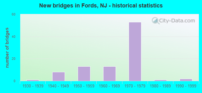
- New bridges - historical statistics
- 11930-1939
- 81940-1949
- 131950-1959
- 131960-1969
- 531970-1979
- 11980-1989
- 21990-1999

- Reconstructed bridges - Historical Statistics
- 21960-1969
- 31970-1979
- 21980-1989
- 01990-1999
- 02000-2009
- 32010-2019


- Bridge Condition - Deck
- 2.7%Very good
- 16.2%Good
- 64.9%Satisfactory
- 16.2%Fair

- Bridge Condition - Superstructure
- 2.7%Very good
- 27.0%Good
- 40.5%Satisfactory
- 29.7%Fair

- Bridge Condition - Substructure
- 32.4%Good
- 54.1%Satisfactory
- 13.5%Fair
Find on map >> Show street view
Structure Number: 1204154, Location: 0.91 MI.N.OF NJTPK EXIT11 (Lat: 40.552689, Lng: -74.317781), Route carried "under" structure: US 1, Year Built: 1995, Structure Length: 0. m, Average Daily Traffic: 49,014 (year 2021), Truck Traffic: 4%, Features Intersected: US ROUTE 1, Facility Carried by Structure: RAMP FROM GSP
Minimum Vertical Clearance: 5.52m (18.11ft), Kilometerpoint: 55.522, Lanes on structure: 1, Lanes under structure: 7, Material/Design: Steel continuous, Design/Construction: Stringer/Multi-beam, Length of Maximum Span: 31.1m (102.0ft)
Find on map >> Show street view
Structure Number: 1234156, Location: 0.6MI WEST OF GSP (Lat: 40.523219, Lng: -74.310139), Route carried "under" structure: State highway 440, Year Built: 1970, Structure Length: 0. m, Average Daily Traffic: 143,055 (year 2020), Truck Traffic: 5%, Features Intersected: NJ 440, Facility Carried by Structure: INDUSTRIAL AV(656)
Minimum Vertical Clearance: 5.41m (17.75ft), Kilometerpoint: 2.350, Lanes on structure: 3, Lanes under structure: 8, Material/Design: Steel, Design/Construction: Stringer/Multi-beam, Length of Maximum Span: 39.0m (128.0ft)
Find on map >> Show street view
Structure Number: 1234157, Location: 0.6MI WEST OF GSP (Lat: 40.522031, Lng: -74.311511), Route carried "under" structure: Ramp State highway 440, Year Built: 1970, Structure Length: 0. m, Average Daily Traffic: 3,171 (year 2020), Truck Traffic: 4%, Features Intersected: RT NJ 440 RAMP-SMITH ST, Facility Carried by Structure: CROWSMILL RD-CR656
Minimum Vertical Clearance: 4.65m (15.26ft), Kilometerpoint: 2.350, Lanes on structure: 2, Lanes under structure: 1, Material/Design: Steel, Design/Construction: Stringer/Multi-beam, Length of Maximum Span: 23.5m (77.1ft)
Find on map >> Show street view
Structure Number: 1234158, Location: 0.4MI WEST OF GSP (Lat: 40.520319, Lng: -74.310450), Route carried "under" structure: Ramp US 9, Year Built: 1970, Structure Length: 0. m, Average Daily Traffic: 1,532 (year 2020), Truck Traffic: 4%, Features Intersected: RT US 9 RAMPS GL&GM, Facility Carried by Structure: SMITH ST(RT. 656)
Minimum Vertical Clearance: 4.60m (15.09ft), Kilometerpoint: 213.721, Lanes on structure: 3, Lanes under structure: 5, Material/Design: Steel, Design/Construction: Stringer/Multi-beam, Length of Maximum Span: 38.1m (125.0ft)
Find on map >> Show street view
Structure Number: 1234159, Location: 0.33 MI WEST OF GSP (Lat: 40.521161, Lng: -74.306661), Route carried "under" structure: State highway 440, Year Built: 1970, Structure Length: 0. m, Average Daily Traffic: 127,295 (year 2021), Truck Traffic: 5%, Features Intersected: NJ 440, Facility Carried by Structure: RAMP GL
Minimum Vertical Clearance: 5.18m (16.99ft), Kilometerpoint: 2.704, Lanes on structure: 2, Lanes under structure: 7, Material/Design: Steel, Design/Construction: Stringer/Multi-beam, Length of Maximum Span: 30.8m (101.0ft)
Find on map >> Show street view
Structure Number: 123416, Location: 0.31 MI SOUTH OF GSP (Lat: 40.520739, Lng: -74.306950), Route carried "under" structure: State highway 440, Year Built: 1970, Structure Length: 0. m, Average Daily Traffic: 145,569 (year 2020), Truck Traffic: 5%, Features Intersected: NJ 440, Facility Carried by Structure: US 9 RAMPS GM & GN
Minimum Vertical Clearance: 5.03m (16.50ft), Kilometerpoint: 2.736, Lanes on structure: 3, Lanes under structure: 7, Material/Design: Steel, Design/Construction: Stringer/Multi-beam, Length of Maximum Span: 32.3m (106.0ft)
Find on map >> Show street view
Structure Number: 1234161, Location: 0.4MI WEST OF GSP (Lat: 40.521569, Lng: -74.305961), Route carried "under" structure: Ramp State highway 440, Year Built: 1970, Structure Length: 0. m, Average Daily Traffic: 6,645 (year 2021), Truck Traffic: 5%, Features Intersected: RAMP GK (NJ 440)
Minimum Vertical Clearance: 4.52m (14.83ft), Kilometerpoint: 2.704, Lanes on structure: 2, Lanes under structure: 3, Material/Design: Steel, Design/Construction: Stringer/Multi-beam, Length of Maximum Span: 35.4m (116.1ft)
Find on map >> Show street view
Structure Number: 1234167, Location: AT JCT RT9,RT440, GSP (Lat: 40.519281, Lng: -74.301681), Route carried "under" structure: Ramp US 9, Year Built: 1970, Structure Length: 0. m, Average Daily Traffic: 8,608 (year 2021), Truck Traffic: 4%, Features Intersected: GSP & ROUTE US 9, Facility Carried by Structure: ROUTE NJ 440
Minimum Vertical Clearance: 9.14m (29.99ft), Kilometerpoint: 214.027, Lanes on structure: 8, Lanes under structure: 2, Material/Design: Steel, Design/Construction: Stringer/Multi-beam, Length of Maximum Span: 51.2m (168.0ft)
Find on map >> Show street view
Structure Number: 1234167, Location: AT JCT RT9,RT440, GSP (Lat: 40.519281, Lng: -74.301681), Route carried "under" structure: Ramp US 9, Year Built: 1970, Structure Length: 0. m, Average Daily Traffic: 5,752 (year 2021), Truck Traffic: 4%, Features Intersected: GSP & ROUTE US 9, Facility Carried by Structure: ROUTE NJ 440
Minimum Vertical Clearance: 11.87m (38.94ft), Kilometerpoint: 214.027, Lanes on structure: 8, Lanes under structure: 1, Material/Design: Steel, Design/Construction: Stringer/Multi-beam, Length of Maximum Span: 51.2m (168.0ft)
Find on map >> Show street view
Structure Number: 1234167, Location: AT JCT RT9,RT440, GSP (Lat: 40.519281, Lng: -74.301681), Route carried "under" structure: Other road 444, Year Built: 1970, Structure Length: 0. m, Average Daily Traffic: 273,099 (year 2021), Features Intersected: GSP & ROUTE US 9, Facility Carried by Structure: ROUTE NJ 440
Minimum Vertical Clearance: 5.41m (17.75ft), Kilometerpoint: 205.996, Lanes on structure: 8, Lanes under structure: 10, Toll: On toll road, Material/Design: Steel, Design/Construction: Stringer/Multi-beam, Length of Maximum Span: 51.2m (168.0ft)
Find on map >> Show street view
Structure Number: 1234167, Location: AT JCT RT9,RT440, GSP (Lat: 40.519281, Lng: -74.301681), Route carried "under" structure: Ramp Other road 444, Year Built: 1970, Structure Length: 0. m, Average Daily Traffic: 2,881 (year 2021), Features Intersected: GSP & ROUTE US 9, Facility Carried by Structure: ROUTE NJ 440
Minimum Vertical Clearance: 4.37m (14.34ft), Kilometerpoint: 205.996, Lanes on structure: 8, Lanes under structure: 1, Toll: On toll road, Material/Design: Steel, Design/Construction: Stringer/Multi-beam, Length of Maximum Span: 51.2m (168.0ft)
Find on map >> Show street view
Structure Number: 1234167, Location: AT JCT RT9,RT440, GSP (Lat: 40.519281, Lng: -74.301681), Route carried "under" structure: Ramp Other road 444, Year Built: 1970, Structure Length: 0. m, Average Daily Traffic: 3,733 (year 2021), Truck Traffic: 5%, Features Intersected: GSP & ROUTE US 9, Facility Carried by Structure: ROUTE NJ 440
Minimum Vertical Clearance: 4.57m (14.99ft), Kilometerpoint: 205.996, Lanes on structure: 8, Lanes under structure: 1, Toll: On toll road, Material/Design: Steel, Design/Construction: Stringer/Multi-beam, Length of Maximum Span: 51.2m (168.0ft)
Find on map >> Show street view
Structure Number: 1234167, Location: AT JCT RT9,RT440, GSP (Lat: 40.519281, Lng: -74.301681), Route carried "under" structure: Ramp Other road 444, Year Built: 1970, Structure Length: 0. m, Average Daily Traffic: 3,733 (year 2021), Truck Traffic: 5%, Features Intersected: GSP & ROUTE US 9, Facility Carried by Structure: ROUTE NJ 440
Minimum Vertical Clearance: 4.57m (14.99ft), Kilometerpoint: 205.996, Lanes on structure: 8, Lanes under structure: 2, Toll: On toll road, Material/Design: Steel, Design/Construction: Stringer/Multi-beam, Length of Maximum Span: 51.2m (168.0ft)
Find on map >> Show street view
Structure Number: 1234167, Location: AT JCT RT9,RT440, GSP (Lat: 40.519281, Lng: -74.301681), Route carried "under" structure: US 9, Year Built: 1970, Structure Length: 0. m, Average Daily Traffic: 97,440 (year 2021), Truck Traffic: 4%, Features Intersected: GSP & ROUTE US 9, Facility Carried by Structure: ROUTE NJ 440
Minimum Vertical Clearance: 9.17m (30.09ft), Kilometerpoint: 214.027, Lanes on structure: 8, Lanes under structure: 6, Material/Design: Steel, Design/Construction: Stringer/Multi-beam, Length of Maximum Span: 51.2m (168.0ft)
Find on map >> Show street view
Structure Number: 1234167, Location: AT JCT RT9,RT440, GSP (Lat: 40.519281, Lng: -74.301681), Route carried "under" structure: Ramp US 9, Year Built: 1970, Structure Length: 0. m, Average Daily Traffic: 7,415 (year 2021), Truck Traffic: 4%, Features Intersected: GSP & ROUTE US 9, Facility Carried by Structure: ROUTE NJ 440
Minimum Vertical Clearance: 11.84m (38.85ft), Kilometerpoint: 214.027, Lanes on structure: 8, Lanes under structure: 1, Material/Design: Steel, Design/Construction: Stringer/Multi-beam, Length of Maximum Span: 51.2m (168.0ft)
Find on map >> Show street view
Structure Number: 1234169, Location: AT JCT OF US440-US9 (Lat: 40.518039, Lng: -74.299381), Route carried "under" structure: Ramp US 9, Year Built: 1972, Structure Length: 0. m, Average Daily Traffic: 48,205 (year 2019), Truck Traffic: 4%, Features Intersected: US 9 NB RAMP
Minimum Vertical Clearance: 4.62m (15.16ft), Kilometerpoint: 213.721, Lanes on structure: 2, Lanes under structure: 2, Material/Design: Steel, Design/Construction: Stringer/Multi-beam, Length of Maximum Span: 26.8m (87.9ft)
Find on map >> Show street view
Structure Number: 123417, Location: 0.25 MI NORTH OF RT440 (Lat: 40.520950, Lng: -74.301450), Route carried "under" structure: Ramp US 9, Year Built: 1972, Structure Length: 0. m, Average Daily Traffic: 13,785 (year 2020), Truck Traffic: 5%, Features Intersected: US 9 RAMP GM
Minimum Vertical Clearance: 4.75m (15.58ft), Kilometerpoint: 214.027, Lanes on structure: 3, Lanes under structure: 2, Material/Design: Steel, Design/Construction: Stringer/Multi-beam, Length of Maximum Span: 29.9m (98.1ft)
Find on map >> Show street view
Structure Number: 1234171, Location: 0.25 MI NORTH OF RT440 (Lat: 40.522439, Lng: -74.299500), Route carried "under" structure: US 9, Year Built: 1970, Structure Length: 0. m, Average Daily Traffic: 74,701 (year 2020), Truck Traffic: 4%, Features Intersected: GSP & US9, Facility Carried by Structure: (NJ 440)RAMP GL
Minimum Vertical Clearance: 5.28m (17.32ft), Kilometerpoint: 214.107, Lanes on structure: 3, Lanes under structure: 8, Material/Design: Steel, Design/Construction: Stringer/Multi-beam, Length of Maximum Span: 25.3m (83.0ft)
Find on map >> Show street view
Structure Number: 1234171, Location: 0.25 MI NORTH OF RT440 (Lat: 40.522439, Lng: -74.299500), Route carried "under" structure: Other road 444, Year Built: 1970, Structure Length: 0. m, Average Daily Traffic: 195,356 (year 2020), Truck Traffic: 5%, Features Intersected: GSP & US9, Facility Carried by Structure: (NJ 440)RAMP GL
Minimum Vertical Clearance: 5.49m (18.01ft), Kilometerpoint: 206.398, Lanes on structure: 3, Lanes under structure: 10, Material/Design: Steel, Design/Construction: Stringer/Multi-beam, Length of Maximum Span: 25.3m (83.0ft)
Find on map >> Show street view
Structure Number: 1234174, Location: 0.23 MI EAST OF US9,GSP (Lat: 40.518639, Lng: -74.297050), Route carried "under" structure: Ramp State highway 9, Year Built: 1972, Structure Length: 0. m, Average Daily Traffic: 5,011 (year 2022), Truck Traffic: 4%, Features Intersected: US 9 RAMP GX
Minimum Vertical Clearance: 4.42m (14.50ft), Kilometerpoint: 213.882, Lanes on structure: 1, Lanes under structure: 1, Material/Design: Steel, Design/Construction: Stringer/Multi-beam, Length of Maximum Span: 25.9m (85.0ft)
Find on map >> Show street view
Structure Number: 1234175, Location: 0.25 EAST OF GSP (Lat: 40.519650, Lng: -74.296669), Route carried "under" structure: Ramp US 9, Year Built: 1972, Structure Length: 0. m, Average Daily Traffic: 8,303 (year 2020), Truck Traffic: 4%, Features Intersected: US 9 RAMP GT, Facility Carried by Structure: NJ 440 & RAMP GW
Minimum Vertical Clearance: 4.55m (14.93ft), Kilometerpoint: 214.091, Lanes on structure: 7, Lanes under structure: 2, Material/Design: Steel, Design/Construction: Stringer/Multi-beam, Length of Maximum Span: 25.9m (85.0ft)
Find on map >> Show street view
Structure Number: 124115, Location: At JCT of NJ 184 & US 9 (Lat: 40.534539, Lng: -74.297361), Route carried "under" structure: US 9, Year Built: 1938, Structure Length: 0. m, Average Daily Traffic: 74,411 (year 2021), Truck Traffic: 4%, Features Intersected: US 9, Facility Carried by Structure: NJ 184
Minimum Vertical Clearance: 4.75m (15.58ft), Kilometerpoint: 215.765, Lanes on structure: 4, Lanes under structure: 6, Material/Design: Steel, Design/Construction: Stringer/Multi-beam, Length of Maximum Span: 14.9m (48.9ft)
Find on map >> Show street view
Structure Number: 361280A, Location: AT GSP & US RT.9 JCT (Lat: 40.518983, Lng: -74.300411), Route carried "under" structure: US 9, Year Built: 1953, Structure Length: 0. m, Average Daily Traffic: 87,335 (year 2021), Truck Traffic: 4%, Features Intersected: US RT.9 SB & RAMP M, Facility Carried by Structure: GSP RAMP Y
Minimum Vertical Clearance: 4.55m (14.93ft), Kilometerpoint: 214.091, Lanes on structure: 3, Lanes under structure: 3, Material/Design: Steel, Design/Construction: Girder and Floorbeam System, Length of Maximum Span: 47.2m (154.9ft)
Find on map >> Show street view
Structure Number: 361280A, Location: AT GSP & US RT.9 JCT (Lat: 40.518983, Lng: -74.300411), Route carried "under" structure: Ramp US 9, Year Built: 1953, Structure Length: 0. m, Average Daily Traffic: 48,318 (year 2021), Truck Traffic: 4%, Features Intersected: US RT.9 SB & RAMP M, Facility Carried by Structure: GSP RAMP Y
Minimum Vertical Clearance: 5.82m (19.09ft), Kilometerpoint: 213.721, Lanes on structure: 3, Lanes under structure: 2, Material/Design: Steel, Design/Construction: Girder and Floorbeam System, Length of Maximum Span: 47.2m (154.9ft)
Find on map >> Show street view
Structure Number: 361280B, Location: AT GSP & RT 440 JCT (Lat: 40.520000, Lng: -74.300125), Route carried "under" structure: US 9, Year Built: 1968, Structure Length: 0. m, Average Daily Traffic: 88,382 (year 2021), Truck Traffic: 4%, Features Intersected: US 9 NB INNER & OUTER, Facility Carried by Structure: GSP NB RAMP GY >
Minimum Vertical Clearance: 5.13m (16.83ft), Kilometerpoint: 214.091, Lanes on structure: 3, Lanes under structure: 2, Material/Design: Steel, Design/Construction: Stringer/Multi-beam, Length of Maximum Span: 36.6m (120.1ft)
Find on map >> Show street view
Structure Number: 361280B, Location: AT GSP & RT 440 JCT (Lat: 40.520000, Lng: -74.300125), Route carried "under" structure: Ramp US 9, Year Built: 1968, Structure Length: 0. m, Average Daily Traffic: 88,382 (year 2021), Truck Traffic: 1%, Features Intersected: US 9 NB INNER & OUTER, Facility Carried by Structure: GSP NB RAMP GY >
Minimum Vertical Clearance: 4.62m (15.16ft), Kilometerpoint: 214.091, Lanes on structure: 3, Lanes under structure: 3, Material/Design: Steel, Design/Construction: Stringer/Multi-beam, Length of Maximum Span: 36.6m (120.1ft)
Find on map >> Show street view
Structure Number: 361281N, Location: AT GSP & RT 440 JCT (Lat: 40.520197, Lng: -74.300825), Route carried "under" structure: Ramp US 9, Year Built: 1968, Structure Length: 0. m, Average Daily Traffic: 47,369 (year 2021), Truck Traffic: 4%, Features Intersected: US RTE 9 & RAMP M, Facility Carried by Structure: GSP NB
Minimum Vertical Clearance: 7.11m (23.33ft), Kilometerpoint: 214.107, Lanes on structure: 5, Lanes under structure: 2, Material/Design: Steel, Design/Construction: Stringer/Multi-beam, Length of Maximum Span: 50.9m (167.0ft)
Find on map >> Show street view
Structure Number: 361281N, Location: AT GSP & RT 440 JCT (Lat: 40.520197, Lng: -74.300825), Route carried "under" structure: US 9, Year Built: 1968, Structure Length: 0. m, Average Daily Traffic: 85,378 (year 2021), Truck Traffic: 4%, Features Intersected: US RTE 9 & RAMP M, Facility Carried by Structure: GSP NB
Minimum Vertical Clearance: 4.78m (15.68ft), Kilometerpoint: 214.107, Lanes on structure: 5, Lanes under structure: 3, Material/Design: Steel, Design/Construction: Stringer/Multi-beam, Length of Maximum Span: 50.9m (167.0ft)
Find on map >> Show street view
Structure Number: 361281S, Location: AT GSP & RT 440 JCT (Lat: 40.520414, Lng: -74.301069), Route carried "under" structure: US 9, Year Built: 1968, Structure Length: 0. m, Average Daily Traffic: 85,378 (year 2021), Truck Traffic: 4%, Features Intersected: US 9 SB & RAMP M, Facility Carried by Structure: GSP SB
Minimum Vertical Clearance: 4.95m (16.24ft), Kilometerpoint: 214.107, Lanes on structure: 5, Lanes under structure: 3, Material/Design: Steel, Design/Construction: Stringer/Multi-beam, Length of Maximum Span: 52.1m (170.9ft)
Find on map >> Show street view
Structure Number: 361281S, Location: AT GSP & RT 440 JCT (Lat: 40.520414, Lng: -74.301069), Route carried "under" structure: Ramp US 9, Year Built: 1968, Structure Length: 0. m, Average Daily Traffic: 47,369 (year 2021), Truck Traffic: 4%, Features Intersected: US 9 SB & RAMP M, Facility Carried by Structure: GSP SB
Minimum Vertical Clearance: 8.84m (29.00ft), Kilometerpoint: 214.107, Lanes on structure: 5, Lanes under structure: 2, Material/Design: Steel, Design/Construction: Stringer/Multi-beam, Length of Maximum Span: 52.1m (170.9ft)
Find on map >> Show street view
Structure Number: 361284T, Location: 0.4 MI NO. OF INT 127 GSP (Lat: 40.524908, Lng: -74.299381), Route carried "under" structure: Other road GSP, Year Built: 1953, Structure Length: 0. m, Average Daily Traffic: 187,450 (year 2021), Truck Traffic: 1%, Features Intersected: RTE US 9 & G.S. PARKWAY, Facility Carried by Structure: NEW BRUNSWICK AVE
Minimum Vertical Clearance: 5.18m (16.99ft), Kilometerpoint: 206.624, Lanes on structure: 2, Lanes under structure: 10, Toll: On toll road, Material/Design: Steel, Design/Construction: Stringer/Multi-beam, Length of Maximum Span: 33.2m (108.9ft)
Find on map >> Show street view
Structure Number: 361284T, Location: 0.4 MI NO. OF INT 127 GSP (Lat: 40.524908, Lng: -74.299381), Route carried "under" structure: US 9, Year Built: 1953, Structure Length: 0. m, Average Daily Traffic: 90,137 (year 2021), Truck Traffic: 4%, Features Intersected: RTE US 9 & G.S. PARKWAY, Facility Carried by Structure: NEW BRUNSWICK AVE
Minimum Vertical Clearance: 4.95m (16.24ft), Kilometerpoint: 214.654, Lanes on structure: 2, Lanes under structure: 8, Material/Design: Steel, Design/Construction: Stringer/Multi-beam, Length of Maximum Span: 33.2m (108.9ft)
Find on map >> Show street view
Structure Number: 361287S, Location: .75 MI N OF GSP&RT440 JCT (Lat: 40.529461, Lng: -74.298336), Route carried "under" structure: US 9, Year Built: 1953, Structure Length: 0. m, Average Daily Traffic: 46,608 (year 2021), Truck Traffic: 4%, Features Intersected: US ROUTE 9 (SOUTH BOUND), Facility Carried by Structure: GSP (SB ROADWAY)
Minimum Vertical Clearance: 4.55m (14.93ft), Kilometerpoint: 215.169, Lanes on structure: 4, Lanes under structure: 3, Material/Design: Steel, Design/Construction: Stringer/Multi-beam, Length of Maximum Span: 58.5m (191.9ft)
Find on map >> Show street view
Structure Number: 361288A, Location: 1.92 MI SOUTH OF US 1 (Lat: 40.530931, Lng: -74.297869), Route carried "under" structure: US 9, Year Built: 1948, Structure Length: 0. m, Average Daily Traffic: 45,512 (year 2021), Truck Traffic: 4%, Features Intersected: US ROUTE 9 SB, Facility Carried by Structure: GSP NB
Minimum Vertical Clearance: 5.00m (16.40ft), Kilometerpoint: 215.169, Lanes on structure: 2, Lanes under structure: 3, Material/Design: Steel, Design/Construction: Girder and Floorbeam System, Length of Maximum Span: 38.4m (126.0ft)
Find on map >> Show street view
Structure Number: 361292T, Location: AT JCT OF RT 184 & GSP (Lat: 40.534578, Lng: -74.301503), Route carried "under" structure: Other road GSP, Year Built: 1969, Structure Length: 0. m, Average Daily Traffic: 75,896 (year 2021), Truck Traffic: 1%, Features Intersected: GSP & RAMPS TK&KT, Facility Carried by Structure: KING GEORGES POST
Minimum Vertical Clearance: 4.75m (15.58ft), Kilometerpoint: 207.798, Lanes on structure: 4, Lanes under structure: 9, Toll: On toll road, Material/Design: Prestressed concrete, Design/Construction: Stringer/Multi-beam, Length of Maximum Span: 28.0m (91.9ft)
Find on map >> Show street view
Structure Number: 361292T, Location: AT JCT OF RT 184 & GSP (Lat: 40.534578, Lng: -74.301503), Route carried "under" structure: Ramp Other road GSP, Year Built: 1969, Structure Length: 0. m, Average Daily Traffic: 11,837 (year 2021), Truck Traffic: 1%, Features Intersected: GSP & RAMPS TK&KT, Facility Carried by Structure: KING GEORGES POST
Minimum Vertical Clearance: 4.85m (15.91ft), Kilometerpoint: 207.798, Lanes on structure: 4, Lanes under structure: 3, Toll: On toll road, Material/Design: Prestressed concrete, Design/Construction: Stringer/Multi-beam, Length of Maximum Span: 28.0m (91.9ft)
Find on map >> Show street view
Structure Number: 361292T, Location: AT JCT OF RT 184 & GSP (Lat: 40.534578, Lng: -74.301503), Route carried "under" structure: Ramp Other road GSP, Year Built: 1969, Structure Length: 0. m, Average Daily Traffic: 11,837 (year 2021), Truck Traffic: 1%, Features Intersected: GSP & RAMPS TK&KT, Facility Carried by Structure: KING GEORGES POST
Minimum Vertical Clearance: 4.60m (15.09ft), Kilometerpoint: 207.798, Lanes on structure: 4, Lanes under structure: 3, Toll: On toll road, Material/Design: Prestressed concrete, Design/Construction: Stringer/Multi-beam, Length of Maximum Span: 28.0m (91.9ft)
Find on map >> Show street view
Structure Number: 361297A, Location: 0.95 MI NORTH OF ROUTE 9 (Lat: 40.540856, Lng: -74.307994), Route carried "under" structure: Interstate 95, Year Built: 1970, Structure Length: 0. m, Average Daily Traffic: 206,396 (year 2021), Truck Traffic: 9%, Features Intersected: NJ TURNPIKE ROADWAYS, Facility Carried by Structure: GSP NB RAMP
Minimum Vertical Clearance: 5.43m (17.81ft), Kilometerpoint: 72.195, Lanes on structure: 2, Lanes under structure: 12, Toll: On toll road, Material/Design: Steel continuous, Design/Construction: Stringer/Multi-beam, Length of Maximum Span: 36.0m (118.1ft)
Find on map >> Show street view
Structure Number: 361297T, Location: 0.95 MI NORTH OF RT 9 (Lat: 40.540783, Lng: -74.308536), Route carried "under" structure: Interstate 95, Year Built: 1948, Structure Length: 0. m, Average Daily Traffic: 206,396 (year 2021), Truck Traffic: 9%, Features Intersected: NJTPK, Facility Carried by Structure: GSP
Minimum Vertical Clearance: 5.43m (17.81ft), Kilometerpoint: 72.227, Lanes on structure: 7, Lanes under structure: 12, Toll: On toll road, Material/Design: Steel continuous, Design/Construction: Stringer/Multi-beam, Length of Maximum Span: 35.7m (117.1ft)
Find on map >> Show street view
Structure Number: 361306T, Location: 1.35 MI SOUTH OF RT27 (Lat: 40.552708, Lng: -74.317181), Route carried "under" structure: US 1, Year Built: 1948, Structure Length: 0. m, Average Daily Traffic: 115,165 (year 2021), Truck Traffic: 4%, Features Intersected: US ROUTE 1, Facility Carried by Structure: GSP
Minimum Vertical Clearance: 4.72m (15.49ft), Kilometerpoint: 55.603, Lanes on structure: 12, Lanes under structure: 7, Material/Design: Steel, Design/Construction: Stringer/Multi-beam, Length of Maximum Span: 17.7m (58.1ft)
Find on map >> Show street view
Structure Number: I09099C, Location: 0.18 MI SE OF NJ.TPK. (Lat: 40.538333, Lng: -74.306667), Route carried "under" structure: Ramp Interstate 95, Year Built: 1970, Structure Length: 0. m, Average Daily Traffic: 4,300 (year 2021), Features Intersected: NJTPK INTER 11 RAMP PNT, Facility Carried by Structure: GARDEN STATE PKWY
Minimum Vertical Clearance: 4.57m (14.99ft), Kilometerpoint: 72.292, Lanes on structure: 8, Lanes under structure: 2, Toll: On toll road, Material/Design: Concrete, Design/Construction: Stringer/Multi-beam, Length of Maximum Span: 20.1m (65.9ft)
Find on map >> Show street view
Structure Number: I09099D, Location: 0.20 MI SE OF NJ TPK (Lat: 40.538333, Lng: -74.306667), Route carried "under" structure: Other road GSP, Year Built: 1970, Structure Length: 0. m, Average Daily Traffic: 160,530 (year 2021), Truck Traffic: 1%, Features Intersected: GARDEN STATE PARKWAY, Facility Carried by Structure: NJ TPK INT 11 TPS
Minimum Vertical Clearance: 4.75m (15.58ft), Kilometerpoint: 208.410, Lanes on structure: 3, Lanes under structure: 7, Toll: On toll road, Material/Design: Steel, Design/Construction: Stringer/Multi-beam, Length of Maximum Span: 30.5m (100.1ft)
Find on map >> Show street view
Structure Number: I09099E, Location: 0.05 MI E OF GSP (Lat: 40.536667, Lng: -74.303333), Route carried "under" structure: Ramp Interstate GSP, Year Built: 1970, Structure Length: 0. m, Average Daily Traffic: 3,954 (year 2021), Truck Traffic: 1%, Features Intersected: NJTPK INTER 11 RAMP PST, Facility Carried by Structure: NJTPK INT.11 R.KPN
Minimum Vertical Clearance: 4.39m (14.40ft), Kilometerpoint: 207.927, Lanes on structure: 2, Lanes under structure: 2, Toll: On toll road, Material/Design: Steel, Design/Construction: Stringer/Multi-beam, Length of Maximum Span: 34.7m (113.8ft)
Find on map >> Show street view
Structure Number: I09099G, Location: 0.25 MI SE OF NJ TPK (Lat: 40.538128, Lng: -74.306850), Route carried "under" structure: Ramp Other road GSP, Year Built: 1970, Structure Length: 0. m, Average Daily Traffic: 9,000 (year 2021), Features Intersected: GARDEN ST PKWY RAMP PNK, Facility Carried by Structure: NJTPK INT.11 RP.TK
Minimum Vertical Clearance: 4.88m (16.01ft), Kilometerpoint: 208.410, Lanes on structure: 1, Lanes under structure: 2, Toll: On toll road, Material/Design: Steel, Design/Construction: Stringer/Multi-beam, Length of Maximum Span: 22.6m (74.1ft)
Find on map >> Show street view
Structure Number: I09132B, Location: .15 MI S US 9 & NJ TPK (Lat: 40.541667, Lng: -74.293333), Route carried "under" structure: Ramp Interstate 95, Year Built: 1950, Structure Length: 0. m, Average Daily Traffic: 30,603 (year 2021), Truck Traffic: 9%, Features Intersected: NJ TPK INT NO.11 RP.NTTN, Facility Carried by Structure: US RTE 9
Minimum Vertical Clearance: 4.82m (15.81ft), Kilometerpoint: 73.692, Lanes on structure: 6, Lanes under structure: 3, Toll: On toll road, Material/Design: Steel, Design/Construction: Stringer/Multi-beam, Length of Maximum Span: 23.5m (77.1ft)
Find on map >> Show street view
Structure Number: I09132B, Location: .15 MI S US 9 & NJ TPK (Lat: 40.541667, Lng: -74.293333), Route carried "under" structure: Ramp Interstate 95, Year Built: 1950, Structure Length: 0. m, Average Daily Traffic: 30,603 (year 2021), Truck Traffic: 9%, Features Intersected: NJ TPK INT NO.11 RP.NTTN, Facility Carried by Structure: US RTE 9
Minimum Vertical Clearance: 5.28m (17.32ft), Kilometerpoint: 73.692, Lanes on structure: 6, Lanes under structure: 3, Toll: On toll road, Material/Design: Steel, Design/Construction: Stringer/Multi-beam, Length of Maximum Span: 23.5m (77.1ft)
Find on map >> Show street view
Structure Number: M08973, Location: 0.5 MI S OF GSP (Lat: 40.538950, Lng: -74.317519), Route carried "under" structure: Interstate 95, Year Built: 1950, Structure Length: 0. m, Average Daily Traffic: 90,656 (year 2021), Truck Traffic: 20%, Features Intersected: NJ TURNPIKE RWYS, Facility Carried by Structure: FORD AVENUE
Minimum Vertical Clearance: 4.78m (15.68ft), Kilometerpoint: 71.423, Lanes on structure: 2, Lanes under structure: 12, Toll: On toll road, Material/Design: Steel, Design/Construction: Stringer/Multi-beam, Length of Maximum Span: 20.7m (67.9ft)
Find on map >> Show street view
Structure Number: M09010A, Location: 0.13 MI SW OF GSP (Lat: 40.540667, Lng: -74.310944), Route carried "under" structure: Interstate 95, Year Built: 1970, Structure Length: 0. m, Average Daily Traffic: 91,800 (year 2021), Truck Traffic: 20%, Features Intersected: NJ TURNPIKE RWYS, Facility Carried by Structure: MILE 90 U-TURN
Minimum Vertical Clearance: 5.36m (17.59ft), Kilometerpoint: 71.970, Lanes on structure: 2, Lanes under structure: 12, Toll: On toll road, Material/Design: Steel, Design/Construction: Stringer/Multi-beam, Length of Maximum Span: 39.0m (128.0ft)
Find on map >> Show street view
Structure Number: M09021A, Location: 0.95 MI NORTH OF ROUTE 9 (Lat: 40.541300, Lng: -74.309139), Route carried "under" structure: Interstate 95, Year Built: 1970, Structure Length: 0. m, Average Daily Traffic: 153,000 (year 2021), Truck Traffic: 14%, Features Intersected: NJ TURNPIKE ROADWAYS, Facility Carried by Structure: NJTPK INT.11 R.PNT
Minimum Vertical Clearance: 5.31m (17.42ft), Kilometerpoint: 72.195, Lanes on structure: 2, Lanes under structure: 12, Toll: On toll road, Material/Design: Steel continuous, Design/Construction: Stringer/Multi-beam, Length of Maximum Span: 35.7m (117.1ft)
Find on map >> Show street view
Structure Number: M09023A, Location: 0.95 MI N OF US ROUTE 9 (Lat: 40.541667, Lng: -74.308333), Route carried "under" structure: Other road GSP, Year Built: 1949, Structure Length: 0. m, Average Daily Traffic: 108,388 (year 2021), Truck Traffic: 1%, Features Intersected: GSP & NJTPK, Facility Carried by Structure: MAIN STREET
Minimum Vertical Clearance: 5.18m (16.99ft), Kilometerpoint: 208.764, Lanes on structure: 2, Lanes under structure: 11, Toll: On toll road, Material/Design: Steel, Design/Construction: Stringer/Multi-beam, Length of Maximum Span: 46.6m (152.9ft)
Find on map >> Show street view
Structure Number: M09084A, Location: 0.30 MI W OF RT.9 (Lat: 40.542150, Lng: -74.296561), Route carried "under" structure: Ramp Interstate 95, Year Built: 1970, Structure Length: 0. m, Average Daily Traffic: 5,100 (year 2021), Features Intersected: NJ TPK INTER.11 RAMP SIT, Facility Carried by Structure: NJ TPK SNO ROADWAY
Minimum Vertical Clearance: 5.31m (17.42ft), Kilometerpoint: 73.225, Lanes on structure: 4, Lanes under structure: 2, Toll: On toll road, Material/Design: Steel, Design/Construction: Stringer/Multi-beam, Length of Maximum Span: 27.4m (89.9ft)
Find on map >> Show street view
Structure Number: M09099A, Location: 0.25 MI W OF ROUTE 9 (Lat: 40.542469, Lng: -74.293981), Route carried "under" structure: Interstate 95, Year Built: 1970, Structure Length: 0. m, Average Daily Traffic: 115,000 (year 2021), Features Intersected: NJTPK NSI-SNI-SNO RWYS, Facility Carried by Structure: NJTPK INT.11 R.TSI
Minimum Vertical Clearance: 5.87m (19.26ft), Kilometerpoint: 73.467, Lanes on structure: 1, Lanes under structure: 9, Toll: On toll road, Material/Design: Steel, Design/Construction: Stringer/Multi-beam, Length of Maximum Span: 26.2m (86.0ft)
Find on map >> Show street view
Structure Number: M09099B, Location: 0.22 MI W OF ROUTE 9 (Lat: 40.541217, Lng: -74.294750), Route carried "under" structure: Ramp Interstate 95, Year Built: 1970, Structure Length: 0. m, Average Daily Traffic: 26,000 (year 2021), Truck Traffic: 9%, Features Intersected: NJ TPK INTER.11 RAMP NT, Facility Carried by Structure: NJ TPK INTER.11 TS
Minimum Vertical Clearance: 4.88m (16.01ft), Kilometerpoint: 73.467, Lanes on structure: 2, Lanes under structure: 3, Toll: On toll road, Material/Design: Steel, Design/Construction: Stringer/Multi-beam, Length of Maximum Span: 29.6m (97.1ft)
Find on map >> Show street view
Structure Number: M09103A, Location: 0.20 MI W OF ROUTE 9 (Lat: 40.542500, Lng: -74.293625), Route carried "under" structure: Interstate 95, Year Built: 1970, Structure Length: 0. m, Average Daily Traffic: 117,670 (year 2021), Features Intersected: NJTPK NSI-SNI-SNO RDWY, Facility Carried by Structure: NJTPK INT.11 R.TSO
Minimum Vertical Clearance: 5.13m (16.83ft), Kilometerpoint: 73.467, Lanes on structure: 1, Lanes under structure: 9, Toll: On toll road, Material/Design: Steel, Design/Construction: Stringer/Multi-beam, Length of Maximum Span: 23.5m (77.1ft)