Bridge Statistics for Fort Carson, Colorado (CO)
Condition, Traffic, Stress, Structural Evaluation, Project Costs
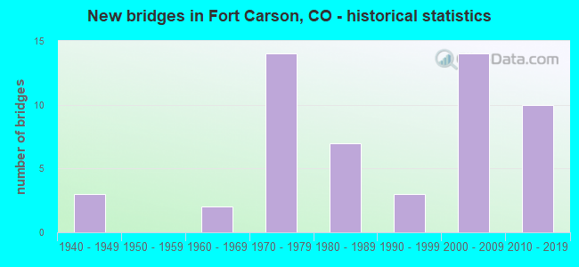
- New bridges - historical statistics
- 31940-1949
- 21960-1969
- 141970-1979
- 71980-1989
- 31990-1999
- 142000-2009
- 102010-2019
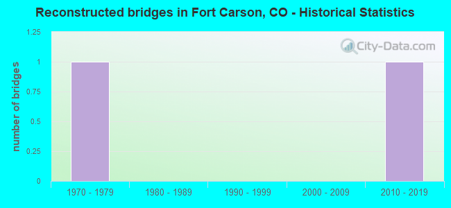
- Reconstructed bridges - Historical Statistics
- 11970-1979
- 01980-1989
- 01990-1999
- 02000-2009
- 12010-2019

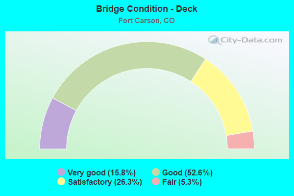
- Bridge Condition - Deck
- 15.8%Very good
- 52.6%Good
- 26.3%Satisfactory
- 5.3%Fair
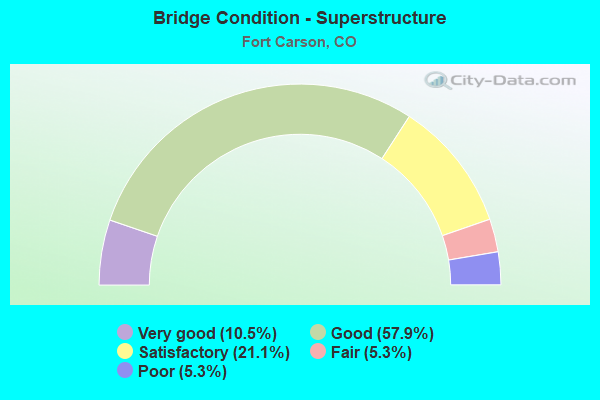
- Bridge Condition - Superstructure
- 10.5%Very good
- 57.9%Good
- 21.1%Satisfactory
- 5.3%Fair
- 5.3%Poor
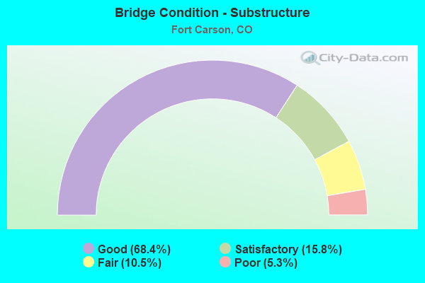
- Bridge Condition - Substructure
- 68.4%Good
- 15.8%Satisfactory
- 10.5%Fair
- 5.3%Poor
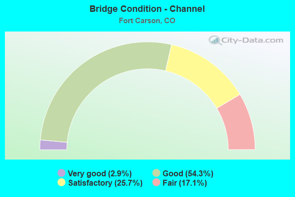
- Bridge Condition - Channel
- 2.9%Very good
- 54.3%Good
- 25.7%Satisfactory
- 17.1%Fair
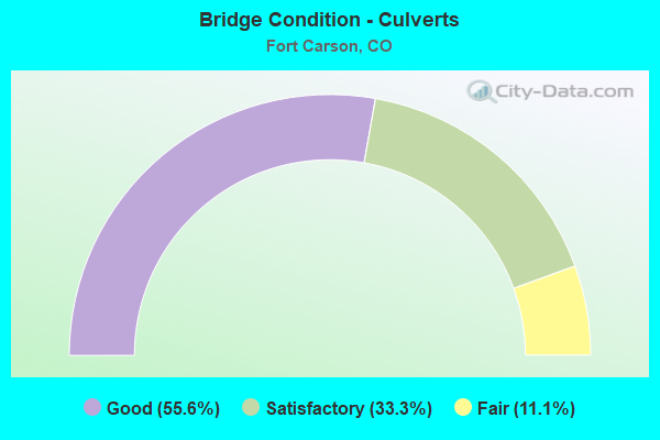
- Bridge Condition - Culverts
- 55.6%Good
- 33.3%Satisfactory
- 11.1%Fair
Find on map >> Show street view
Structure Number: T85126, Location: Prussman and Sheridan Ave (Lat: 38.735419, Lng: -104.791900), Route carried "on" structure: Other road , Year Built: 1992, Status: Open, Structure Length: 1.75m (5.74ft), Average Daily Traffic: 400 (year 2021), Truck Traffic: 10%, Average Future Daily Traffic: 480 (year 2043), Features Intersected: C Ditch, Facility Carried by Structure: Prussman Blvd.
Minimum Vertical Clearance: 30+ m (98+ ft), Kilometerpoint: 0.000, Lanes on structure: 3, Owner: Army, Approaching Roadway Width: 11.0m (36.1ft), Material/Design: Concrete, Design/Construction: Culvert, Number Of Spans In Main Unit: 5, Length of Maximum Span: 3.0m (9.8ft), Curb or Sidewalk Widths: Left: 1.7m (5.6ft), Right: 2.8m (9.2ft), Curb-To-Curb Width: 15.5m (50.9ft), Out-to-Out Width: 20.2m (66.3ft)
Condition: Channel: Fair, Culverts: Fair, Operating Rating: 54.4 metric tons, Method Used To Determine Operating Rating: Field evaluation and documented engineering judgment, Inventory Rating: 32.7 metric tons, Method Used To Determine Inventory Rating: Field evaluation and documented engineering judgment, Structural Evaluation: Somewhat better than minimum adequacy, Deck Geometry: Equal to present minimum criteria, Waterway Adequacy: Better than present minimum criteria, Approach Roadway Alignment: Equal to present desirable criteria, Length Of Structure Improvement: 2.45m (8.04ft), Designated Inspection Frequency: Every 24 months, Inspection Date: August 2021, Bridge Improvement Cost: $14,000, Roadway Improvement Cost: $10,000, Total Project Cost: $24,000 ( Estimate for 2021)
Find on map >> Show street view
Structure Number: T85127, Location: Prussman and Barkeley Ave (Lat: 38.741219, Lng: -104.782900), Route carried "on" structure: Other road , Year Built: 1989, Status: Open, Structure Length: 0.98m (3.22ft), Average Daily Traffic: 500 (year 2015), Truck Traffic: 10%, Average Future Daily Traffic: 600 (year 2043), Features Intersected: Clover Ditch, Facility Carried by Structure: Prussman Blvd.
Minimum Vertical Clearance: 30+ m (98+ ft), Kilometerpoint: 0.000, Lanes on structure: 2, Owner: Army, Approaching Roadway Width: 14.0m (45.9ft), Material/Design: Concrete, Design/Construction: Culvert, Number Of Spans In Main Unit: 4, Length of Maximum Span: 2.2m (7.2ft), Curb or Sidewalk Widths: Left: 1.7m (5.6ft), Right: 2.2m (7.2ft), Curb-To-Curb Width: 14.0m (45.9ft), Out-to-Out Width: 20.1m (65.9ft)
Condition: Channel: Fair, Culverts: Good, Operating Rating: 54.4 metric tons, Method Used To Determine Operating Rating: Field evaluation and documented engineering judgment, Inventory Rating: 32.7 metric tons, Method Used To Determine Inventory Rating: Field evaluation and documented engineering judgment, Structural Evaluation: Better than present minimum criteria, Deck Geometry: Superior to present desirable criteria, Waterway Adequacy: Equal to present minimum criteria, Approach Roadway Alignment: Equal to present desirable criteria, Length Of Structure Improvement: 1.66m (5.45ft), Designated Inspection Frequency: Every 24 months, Inspection Date: August 2021, Bridge Improvement Cost: $1,000, Roadway Improvement Cost: $1,000, Total Project Cost: $2,000 ( Estimate for 2021)
Find on map >> Show street view
Structure Number: T85131, Location: 100 YD E INT W/BARKELEY (Lat: 38.725481, Lng: -104.756700), Route carried "on" structure: Other road , Year Built: 2008, Status: Open, Structure Length: 4.40m (14.44ft), Average Daily Traffic: 1,000 (year 2015), Truck Traffic: 10%, Average Future Daily Traffic: 1,200 (year 2043), Features Intersected: I Ditch, Facility Carried by Structure: Specker Ave.
Minimum Vertical Clearance: 30+ m (98+ ft), Kilometerpoint: 0.000, Lanes on structure: 4, Owner: Army, Approaching Roadway Width: 15.6m (51.2ft), Skew: 3 degrees, Material/Design: Prestressed concrete continuous, Design/Construction: Box Beam or Girders - Multiple, Number Of Spans In Main Unit: 3, Length of Maximum Span: 14.7m (48.2ft), Curb or Sidewalk Widths: Left: 2.1m (6.9ft), Right: 2.1m (6.9ft), Curb-To-Curb Width: 15.9m (52.2ft), Out-to-Out Width: 21.9m (71.9ft)
Condition: Deck: Good, Superstructure: Good, Substructure: Good, Channel: Good, Operating Rating: 68.0 metric tons, Method Used To Determine Operating Rating: Field evaluation and documented engineering judgment, Inventory Rating: 40.8 metric tons, Method Used To Determine Inventory Rating: Field evaluation and documented engineering judgment, Structural Evaluation: Better than present minimum criteria, Deck Geometry: Meets minimum limits, Waterway Adequacy: Equal to present minimum criteria, Approach Roadway Alignment: Equal to present desirable criteria, Length Of Structure Improvement: 5.38m (17.65ft), Designated Inspection Frequency: Every 24 months, Inspection Date: August 2021, Bridge Improvement Cost: $1,000, Roadway Improvement Cost: $1,000, Total Project Cost: $2,000 ( Estimate for 2021), Deck Structure Type: Other, Wearing Surface/Protective System: Wearing Surface: Bituminous
Find on map >> Show street view
Structure Number: T85133, Location: .6 mi East of Specker Ave (Lat: 38.725769, Lng: -104.746900), Route carried "on" structure: Other road , Year Built: 1988, Status: Open, Structure Length: 1.09m (3.58ft), Average Daily Traffic: 1,000 (year 2015), Truck Traffic: 10%, Average Future Daily Traffic: 480 (year 2043), Features Intersected: Drainage Ditch, Facility Carried by Structure: McGrath Ave.
Minimum Vertical Clearance: 30+ m (98+ ft), Kilometerpoint: 0.000, Lanes on structure: 4, Owner: Army, Approaching Roadway Width: 14.6m (47.9ft), Material/Design: Concrete, Design/Construction: Culvert, Number Of Spans In Main Unit: 4, Length of Maximum Span: 2.4m (7.9ft), Curb-To-Curb Width: 22.2m (72.8ft), Out-to-Out Width: 25.6m (84.0ft)
Condition: Channel: Good, Culverts: Good, Operating Rating: 54.4 metric tons, Method Used To Determine Operating Rating: Field evaluation and documented engineering judgment, Inventory Rating: 32.7 metric tons, Method Used To Determine Inventory Rating: Field evaluation and documented engineering judgment, Structural Evaluation: Better than present minimum criteria, Deck Geometry: Superior to present desirable criteria, Waterway Adequacy: Better than present minimum criteria, Approach Roadway Alignment: Equal to present desirable criteria, Length Of Structure Improvement: 1.76m (5.77ft), Designated Inspection Frequency: Every 24 months, Inspection Date: August 2021, Bridge Improvement Cost: $1,000, Roadway Improvement Cost: $1,000, Total Project Cost: $2,000 ( Estimate for 2021)
Find on map >> Show street view
Structure Number: T85139, Location: 500 ft SE of Chiles Ave. (Lat: 38.763550, Lng: -104.802600), Route carried "on" structure: Other road , Year Built: 1942, Status: Open, Structure Length: 1.85m (6.07ft), Average Daily Traffic: 30 (year 2015), Average Future Daily Traffic: 30 (year 2043), Features Intersected: B Ditch, Facility Carried by Structure: Wickersham Blvd.
Minimum Vertical Clearance: 30+ m (98+ ft), Kilometerpoint: 0.000, Lanes on structure: 2, Owner: Army, Approaching Roadway Width: 8.5m (27.9ft), Material/Design: Wood or Timber, Design/Construction: Stringer/Multi-beam, Number Of Spans In Main Unit: 4, Length of Maximum Span: 4.6m (15.1ft), Curb-To-Curb Width: 8.6m (28.2ft), Out-to-Out Width: 9.5m (31.2ft)
Condition: Deck: Satisfactory, Superstructure: Good, Substructure: Poor, Channel: Fair, Operating Rating: 34.0 metric tons, Method Used To Determine Operating Rating: Load and Resistance Factor Rating (LRFR) rating reported by rating factor(RF) method using HL-93 loadings, Inventory Rating: 26.2 metric tons, Method Used To Determine Inventory Rating: Load and Resistance Factor Rating (LRFR) rating reported by rating factor(RF) method using HL-93 loadings, Structural Evaluation: Meets minimum limits, Deck Geometry: Better than present minimum criteria, Waterway Adequacy: Equal to present minimum criteria, Approach Roadway Alignment: Equal to present desirable criteria, Length Of Structure Improvement: 2.59m (8.50ft), Designated Inspection Frequency: Every 24 months, Inspection Date: August 2021, Bridge Improvement Cost: $1,000, Roadway Improvement Cost: $1,000, Total Project Cost: $2,000 ( Estimate for 2021), Deck Structure Type: Wood or Timber, Wearing Surface/Protective System: Wearing Surface: Bituminous
Find on map >> Show street view
Structure Number: T8514, Location: OConnell and Chiles Ave. (Lat: 38.748800, Lng: -104.801300), Route carried "on" structure: Other road , Year Built: 1988, Status: Open, Structure Length: 1.34m (4.40ft), Average Daily Traffic: 600 (year 2015), Truck Traffic: 10%, Average Future Daily Traffic: 700 (year 2043), Design Load: HS 20, Features Intersected: I Ditch, Facility Carried by Structure: OConnell Blvd.
Minimum Vertical Clearance: 30+ m (98+ ft), Kilometerpoint: 0.000, Lanes on structure: 2, Owner: Army, Approaching Roadway Width: 11.0m (36.1ft), Material/Design: Concrete, Design/Construction: Culvert, Number Of Spans In Main Unit: 4, Length of Maximum Span: 3.0m (9.8ft), Curb or Sidewalk Widths: Left: 1.8m (5.9ft), Right: 0.0m, Curb-To-Curb Width: 16.1m (52.8ft), Out-to-Out Width: 19.4m (63.6ft)
Condition: Channel: Very good, Culverts: Satisfactory, Operating Rating: 45.0 metric tons, Method Used To Determine Operating Rating: Load and Resistance Factor Rating (LRFR) rating reported by rating factor(RF) method using HL-93 loadings, Inventory Rating: 34.7 metric tons, Method Used To Determine Inventory Rating: Load and Resistance Factor Rating (LRFR) rating reported by rating factor(RF) method using HL-93 loadings, Structural Evaluation: Equal to present minimum criteria, Deck Geometry: Superior to present desirable criteria, Waterway Adequacy: Equal to present desirable criteria, Approach Roadway Alignment: Equal to present desirable criteria, Length Of Structure Improvement: 2.05m (6.73ft), Designated Inspection Frequency: Every 24 months, Inspection Date: August 2021, Bridge Improvement Cost: $1,000, Roadway Improvement Cost: $1,000, Total Project Cost: $2,000 ( Estimate for 2021)
Find on map >> Show street view
Structure Number: EPC4099-00.33L, Location: 1.5 MI W OF I-25 (Lat: 38.766000, Lng: -104.804000), Route carried "under" structure: County highway , Year Built: 2008, Structure Length: 0. m, Features Intersected: WESTMEADOW DRIVE, Facility Carried by Structure: ACADEMY BLVD SB
Minimum Vertical Clearance: 5.55m (18.21ft), Kilometerpoint: 0.000, Lanes on structure: 2, Lanes under structure: 4, Material/Design: Prestressed concrete continuous, Design/Construction: Stringer/Multi-beam, Length of Maximum Span: 28.3m (92.8ft)
Find on map >> Show street view
Structure Number: EPC4099-00.33R, Location: 1.5 MI W. OF I25 (Lat: 38.765703, Lng: -104.804003), Route carried "under" structure: County highway , Year Built: 1979, Structure Length: 0. m, Average Daily Traffic: 5,000 (year 2008), Features Intersected: WESTMEADOW DRIVE, Facility Carried by Structure: ACADEMY BLVD NB
Minimum Vertical Clearance: 5.64m (18.50ft), Kilometerpoint: 0.000, Lanes on structure: 2, Lanes under structure: 4, Material/Design: Prestressed concrete continuous, Design/Construction: Stringer/Multi-beam, Length of Maximum Span: 28.2m (92.5ft)
Find on map >> Show street view
Structure Number: EPC4099-00.67L, Location: 1.2 MI W OF I-25 (Lat: 38.765917, Lng: -104.798278), Route carried "under" structure: County highway , Year Built: 2010, Structure Length: 0. m, Features Intersected: B ST, US ARMY RR, Facility Carried by Structure: ACADEMY BLVD SB
Minimum Vertical Clearance: 7.16m (23.49ft), Kilometerpoint: 0.000, Lanes on structure: 3, Lanes under structure: 4, Material/Design: Prestressed concrete continuous, Design/Construction: Stringer/Multi-beam, Length of Maximum Span: 34.5m (113.2ft)
Find on map >> Show street view
Structure Number: EPC4099-00.67R, Location: 1.2 MI W OF I25 (Lat: 38.765833, Lng: -104.798333), Route carried "under" structure: County highway , Year Built: 1978, Structure Length: 0. m, Average Daily Traffic: 10,000 (year 2008), Features Intersected: B ST, US ARMY RR, Facility Carried by Structure: NB ACADEMY BLVD
Minimum Vertical Clearance: 9.51m (31.20ft), Kilometerpoint: 0.000, Lanes on structure: 2, Lanes under structure: 4, Material/Design: Steel continuous, Design/Construction: Stringer/Multi-beam, Length of Maximum Span: 38.4m (126.0ft)
Find on map >> Show street view
Structure Number: I-17-GR, Location: S. INT. OF ACADEMY & (Lat: 38.764603, Lng: -104.775556), Route carried "under" structure: City street , Year Built: 1971, Structure Length: 0. m, Average Daily Traffic: 36,400 (year 2005), Truck Traffic: 9%, Features Intersected: ACADEMY BLVD, Facility Carried by Structure: I 25 ML SBND
Minimum Vertical Clearance: 6.40m (21.00ft), Kilometerpoint: 0.000, Lanes on structure: 2, Lanes under structure: 7, Material/Design: Steel continuous, Design/Construction: Stringer/Multi-beam, Length of Maximum Span: 45.9m (150.6ft)
Find on map >> Show street view
Structure Number: J-17-D, Location: 1.1 MI S/SH 83 ACADMY BLV (Lat: 38.749389, Lng: -104.811428), Route carried "under" structure: State highway 115A, Year Built: 1964, Structure Length: 0. m, Average Daily Traffic: 2,600 (year 2018), Truck Traffic: 5%, Features Intersected: SH 115 ML, Facility Carried by Structure: FORT CARSON+NORAD
Minimum Vertical Clearance: 5.06m (16.60ft), Kilometerpoint: 0.251, Lanes on structure: 3, Lanes under structure: 6, Material/Design: Concrete continuous, Design/Construction: Tee Beam, Length of Maximum Span: 19.0m (62.3ft)
Find on map >> Show street view
Structure Number: J-18-BM, Location: SECURITY JCT I-25 A (Lat: 38.724689, Lng: -104.733189), Route carried "under" structure: Interstate 25A, Year Built: 2009, Structure Length: 0. m, Average Daily Traffic: 39,000 (year 2011), Truck Traffic: 11%, Features Intersected: I 25 ML, Facility Carried by Structure: SH 16A ML
Minimum Vertical Clearance: 5.33m (17.49ft), Kilometerpoint: 211.809, Lanes on structure: 7, Lanes under structure: 5, Material/Design: Prestressed concrete, Design/Construction: Stringer/Multi-beam, Length of Maximum Span: 33.2m (108.9ft)