Bridge Statistics for Fort Dodge, Iowa (IA)
Condition, Traffic, Stress, Structural Evaluation, Project Costs
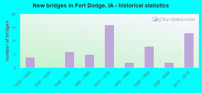
- New bridges - historical statistics
- 41930-1939
- 61950-1959
- 51960-1969
- 161970-1979
- 21980-1989
- 81990-1999
- 22000-2009
- 132010-2019
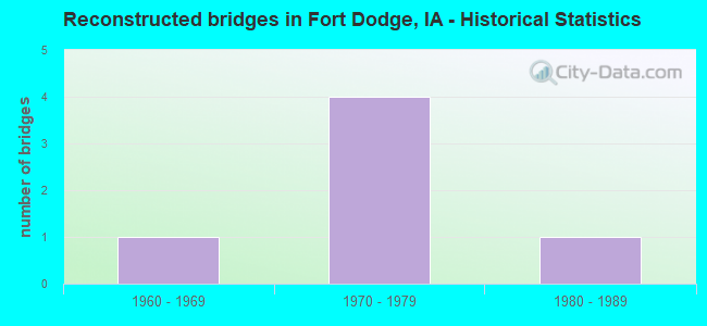
- Reconstructed bridges - Historical Statistics
- 11960-1969
- 41970-1979
- 11980-1989
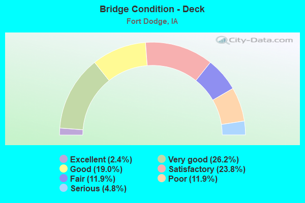
- Bridge Condition - Deck
- 2.4%Excellent
- 26.2%Very good
- 19.0%Good
- 23.8%Satisfactory
- 11.9%Fair
- 11.9%Poor
- 4.8%Serious
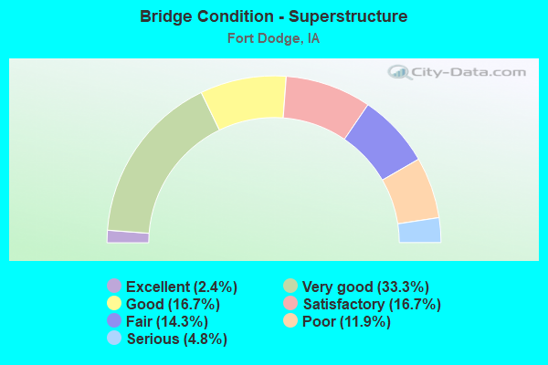
- Bridge Condition - Superstructure
- 2.4%Excellent
- 33.3%Very good
- 16.7%Good
- 16.7%Satisfactory
- 14.3%Fair
- 11.9%Poor
- 4.8%Serious
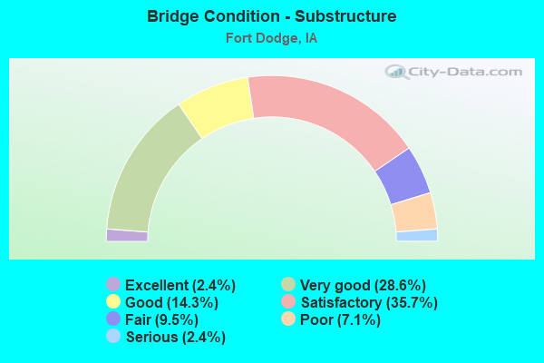
- Bridge Condition - Substructure
- 2.4%Excellent
- 28.6%Very good
- 14.3%Good
- 35.7%Satisfactory
- 9.5%Fair
- 7.1%Poor
- 2.4%Serious
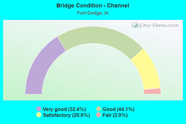
- Bridge Condition - Channel
- 32.4%Very good
- 44.1%Good
- 20.6%Satisfactory
- 2.9%Fair
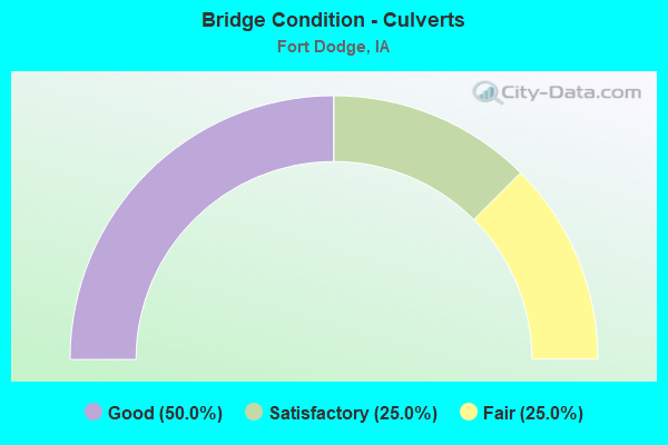
- Bridge Condition - Culverts
- 50.0%Good
- 25.0%Satisfactory
- 25.0%Fair
Find on map >> Show street view
Structure Number: 34382, Location: 090283004 (Lat: 42.586194, Lng: -94.197725), Route carried "on" structure: County highway , Year Built: 1965, Status: Open, Structure Length: 1.59m (5.22ft), Average Daily Traffic: 460 (year 2019), Truck Traffic: 8%, Average Future Daily Traffic: 460 (year 2038), Design Load: HS 20, Features Intersected: BADGER CREEK, Facility Carried by Structure: FM
Minimum Vertical Clearance: 30+ m (98+ ft), Kilometerpoint: 4.807, Lanes on structure: 2, Owner: County Highway Agency, Approaching Roadway Width: 9.1m (29.9ft), Material/Design: Concrete continuous, Design/Construction: Culvert, Number Of Spans In Main Unit: 3, Length of Maximum Span: 5.5m (18.0ft)
Condition: Channel: Satisfactory, Culverts: Satisfactory, Operating Rating: 44.1 metric tons, Method Used To Determine Operating Rating: Assigned rating based on Load Factor Design (LFD) reported in metric tons, Inventory Rating: 32.7 metric tons, Method Used To Determine Inventory Rating: Assigned rating based on Load Factor Design (LFD) reported in metric tons, Structural Evaluation: Equal to present minimum criteria, Waterway Adequacy: Equal to present minimum criteria, Approach Roadway Alignment: Equal to present desirable criteria, Length Of Structure Improvement: 5.20m (17.06ft), Designated Inspection Frequency: Every 48 months, Inspection Date: November 2018, Bridge Improvement Cost: $17,000, Roadway Improvement Cost: $5,000
Find on map >> Show street view
Structure Number: 343841, Location: 090283403 (Lat: 42.572467, Lng: -94.133775), Route carried "on" structure: County highway , Year Built: 2011, Status: Open, Structure Length: 2.53m (8.30ft), Average Daily Traffic: 70 (year 2015), Average Future Daily Traffic: 70 (year 2039), Design Load: HL 93, Features Intersected: DD, Facility Carried by Structure: LOCAL
Minimum Vertical Clearance: 30+ m (98+ ft), Kilometerpoint: 22.991, Lanes on structure: 2, Owner: County Highway Agency, Approaching Roadway Width: 8.5m (27.9ft), Skew: 3 degrees, Material/Design: Concrete continuous, Design/Construction: Slab, Number Of Spans In Main Unit: 3, Length of Maximum Span: 9.4m (30.8ft), Curb-To-Curb Width: 7.5m (24.6ft), Out-to-Out Width: 8.3m (27.2ft)
Condition: Deck: Very good, Superstructure: Very good, Substructure: Very good, Channel: Very good, Operating Rating: 68.1 metric tons, Method Used To Determine Operating Rating: Load Factor (LF), Inventory Rating: 40.8 metric tons, Method Used To Determine Inventory Rating: Load Factor (LF), Structural Evaluation: Equal to present desirable criteria, Deck Geometry: Equal to present minimum criteria, Waterway Adequacy: Equal to present desirable criteria, Approach Roadway Alignment: Better than present minimum criteria, Designated Inspection Frequency: Every 48 months, Inspection Date: November 2019, Deck Structure Type: Concrete Cast-file-Place, Wearing Surface/Protective System: Wearing Surface: Monolithic Concrete
Find on map >> Show street view
Structure Number: 500161, Location: 089281800 (Lat: 42.505572, Lng: -94.198886), Route carried "on" structure: City street , Year Built: 2019, Status: Open, Structure Length: 2.53m (8.30ft), Average Daily Traffic: 1,020 (year 2015), Average Future Daily Traffic: 1,020 (year 2040), Design Load: HL 93, Features Intersected: SOLDIER CREEK, Facility Carried by Structure: N 1ST ST
Minimum Vertical Clearance: 30+ m (98+ ft), Kilometerpoint: 0.233, Lanes on structure: 2, Owner: City or Municipal Highway Agency, Approaching Roadway Width: 9.8m (32.2ft), Material/Design: Prestressed concrete, Design/Construction: Stringer/Multi-beam, Number Of Spans In Main Unit: 1, Length of Maximum Span: 24.4m (80.1ft), Curb or Sidewalk Widths: Left: 0.0m, Right: 3.0m (9.8ft), Curb-To-Curb Width: 9.8m (32.2ft), Out-to-Out Width: 13.9m (45.6ft)
Condition: Deck: Excellent, Superstructure: Excellent, Substructure: Excellent, Channel: Very good, Operating Rating: 42.1 metric tons, Method Used To Determine Operating Rating: Assigned ratings based on Load and Resistance Factor Design (LRFD) reported by rating factor (RF) using HL93 loadings, Inventory Rating: 32.4 metric tons, Method Used To Determine Inventory Rating: Assigned ratings based on Load and Resistance Factor Design (LRFD) reported by rating factor (RF) using HL93 loadings, Structural Evaluation: Equal to present desirable criteria, Deck Geometry: Somewhat better than minimum adequacy, Waterway Adequacy: Equal to present desirable criteria, Approach Roadway Alignment: Equal to present minimum criteria, Designated Inspection Frequency: Every 24 months, Inspection Date: March 2020, Deck Structure Type: Concrete Cast-file-Place, Wearing Surface/Protective System: Wearing Surface: Monolithic Concrete, Deck Protection: Epoxy Coated Reinforcing
Find on map >> Show street view
Structure Number: 504965, Location: 089280900 (Lat: 42.535506, Lng: -94.164242), Route carried "on" structure: City street , Year Built: 1999, Status: Open, Structure Length: 2.77m (9.09ft), Average Daily Traffic: 1,000 (year 2001), Average Future Daily Traffic: 1,000 (year 2041), Design Load: HS 20, Features Intersected: SOLDIER CREEK, Facility Carried by Structure: SOLDIER CR DR
Minimum Vertical Clearance: 30+ m (98+ ft), Kilometerpoint: 0.179, Lanes on structure: 2, Owner: City or Municipal Highway Agency, Approaching Roadway Width: 7.6m (24.9ft), Material/Design: Concrete continuous, Design/Construction: Slab, Number Of Spans In Main Unit: 3, Length of Maximum Span: 10.4m (34.1ft), Curb or Sidewalk Widths: Left: 1.2m (3.9ft), Right: 0.0m, Curb-To-Curb Width: 9.1m (29.9ft), Out-to-Out Width: 11.6m (38.1ft)
Condition: Deck: Fair, Superstructure: Fair, Substructure: Satisfactory, Channel: Satisfactory, Operating Rating: 75.7 metric tons, Method Used To Determine Operating Rating: Load Factor (LF), Inventory Rating: 45.4 metric tons, Method Used To Determine Inventory Rating: Load Factor (LF), Structural Evaluation: Somewhat better than minimum adequacy, Deck Geometry: Equal to present minimum criteria, Waterway Adequacy: Equal to present desirable criteria, Approach Roadway Alignment: Equal to present desirable criteria, Length Of Structure Improvement: 8.80m (28.87ft), Designated Inspection Frequency: Every 24 months, Inspection Date: April 2021, Bridge Improvement Cost: $15,000, Roadway Improvement Cost: $2,000, Deck Structure Type: Concrete Cast-file-Place, Wearing Surface/Protective System: Wearing Surface: Monolithic Concrete
Find on map >> Show street view
Structure Number: 50557, Location: 089291700 (Lat: 42.517706, Lng: -94.186169), Route carried "on" structure: City street , Year Built: 1955, Status: Open, Structure Length: 1.86m (6.10ft), Average Daily Traffic: 1,890 (year 2019), Average Future Daily Traffic: 1,890 (year 2041), Features Intersected: SOLDIER CREEK, Facility Carried by Structure: WILLIAMS DRIVE
Minimum Vertical Clearance: 30+ m (98+ ft), Kilometerpoint: 0.465, Lanes on structure: 2, Owner: City or Municipal Highway Agency, Approaching Roadway Width: 18.3m (60.0ft), Material/Design: Steel, Design/Construction: Culvert, Number Of Spans In Main Unit: 2, Length of Maximum Span: 8.8m (28.9ft)
Condition: Channel: Satisfactory, Culverts: Fair, Operating Rating: 32.7 metric tons, Method Used To Determine Operating Rating: Load Factor (LF), Inventory Rating: 24.5 metric tons, Method Used To Determine Inventory Rating: Load Factor (LF), Structural Evaluation: Somewhat better than minimum adequacy, Waterway Adequacy: Better than present minimum criteria, Approach Roadway Alignment: Equal to present minimum criteria, Designated Inspection Frequency: Every 24 months, Inspection Date: April 2021
Find on map >> Show street view
Structure Number: 606075, Location: At Jct. US 169 (Lat: 42.444997, Lng: -94.184625), Route carried "on" structure: US 20, Year Built: 1990, Status: Open, Structure Length: 7.19m (23.59ft), Average Daily Traffic: 2,270 (year 2020), Truck Traffic: 38%, Average Future Daily Traffic: 2,270 (year 2040), Design Load: HS 20, Features Intersected: US 169
Minimum Vertical Clearance: 30+ m (98+ ft), Kilometerpoint: 184.679, Lanes on structure: 2, Lanes under structure: 4, Base Highway Network: Yes, Owner: State Highway Agency, Approaching Roadway Width: 12.2m (40.0ft), Material/Design: Prestressed concrete, Design/Construction: Stringer/Multi-beam, Number Of Spans In Main Unit: 4, Length of Maximum Span: 21.0m (68.9ft), Curb-To-Curb Width: 12.2m (40.0ft), Out-to-Out Width: 13.2m (43.3ft)
Condition: Deck: Good, Superstructure: Very good, Substructure: Good, Operating Rating: 49.4 metric tons, Method Used To Determine Operating Rating: Load Factor (LF), Inventory Rating: 27.8 metric tons, Method Used To Determine Inventory Rating: Load Factor (LF), Structural Evaluation: Equal to present minimum criteria, Deck Geometry: Better than present minimum criteria, Underclear: Superior to present desirable criteria, Approach Roadway Alignment: Equal to present desirable criteria, Designated Inspection Frequency: Every 24 months, Inspection Date: May 2020, Deck Structure Type: Concrete Cast-file-Place, Wearing Surface/Protective System: Wearing Surface: Monolithic Concrete, Deck Protection: Epoxy Coated Reinforcing
Find on map >> Show street view
Structure Number: 60608, Location: At jct. US 169 (Lat: 42.445183, Lng: -94.183722), Route carried "on" structure: US 20, Year Built: 1990, Status: Open, Structure Length: 7.19m (23.59ft), Average Daily Traffic: 2,270 (year 2020), Truck Traffic: 38%, Average Future Daily Traffic: 2,270 (year 2040), Design Load: HS 20, Features Intersected: US 169
Minimum Vertical Clearance: 30+ m (98+ ft), Kilometerpoint: 298.434, Lanes on structure: 2, Lanes under structure: 4, Owner: State Highway Agency, Approaching Roadway Width: 12.2m (40.0ft), Material/Design: Prestressed concrete, Design/Construction: Stringer/Multi-beam, Number Of Spans In Main Unit: 4, Length of Maximum Span: 21.0m (68.9ft), Curb-To-Curb Width: 12.2m (40.0ft), Out-to-Out Width: 13.2m (43.3ft)
Condition: Deck: Good, Superstructure: Good, Substructure: Good, Operating Rating: 49.4 metric tons, Method Used To Determine Operating Rating: Allowable Stress (AS), Inventory Rating: 27.8 metric tons, Method Used To Determine Inventory Rating: Allowable Stress (AS), Structural Evaluation: Equal to present minimum criteria, Deck Geometry: Better than present minimum criteria, Underclear: Superior to present desirable criteria, Approach Roadway Alignment: Equal to present desirable criteria, Designated Inspection Frequency: Every 24 months, Inspection Date: May 2020, Deck Structure Type: Concrete Cast-file-Place, Wearing Surface/Protective System: Wearing Surface: Monolithic Concrete, Deck Protection: Epoxy Coated Reinforcing
Find on map >> Show street view
Structure Number: 504, Location: 089282000 (Lat: 42.505192, Lng: -94.169628), Route carried "under" structure: City street , Year Built: 1968, Structure Length: 0. m, Average Daily Traffic: 5,700 (year 2015), Features Intersected: 21ST ST & RR, Facility Carried by Structure: 1ST AVE S
Minimum Vertical Clearance: 30+ m (98+ ft), Kilometerpoint: 1.699, Lanes on structure: 2, Lanes under structure: 4, Material/Design: Prestressed concrete, Design/Construction: Stringer/Multi-beam, Length of Maximum Span: 21.0m (68.9ft)
Find on map >> Show street view
Structure Number: 52081, Location: 1.3 MI. N. OF S. JCT.#169 (Lat: 42.495308, Lng: -94.188508), Route carried "under" structure: City street , Year Built: 1935, Structure Length: 0. m, Average Daily Traffic: 230 (year 1995), Features Intersected: DM RIVER & B AVE, Facility Carried by Structure: KENYON RD SB
Minimum Vertical Clearance: 30+ m (98+ ft), Kilometerpoint: 0.684, Lanes on structure: 2, Lanes under structure: 3, Material/Design: Steel continuous, Design/Construction: Truss - Deck, Length of Maximum Span: 41.5m (136.2ft)
Find on map >> Show street view
Structure Number: 52083, Location: 1.3 mi N of S Jct US 169 (Lat: 42.493858, Lng: -94.189150), Route carried "under" structure: City street , Year Built: 1977, Structure Length: 0. m, Average Daily Traffic: 230 (year 1995), Features Intersected: DM RIVER & B AVE, Facility Carried by Structure: KENYON RD NB
Minimum Vertical Clearance: 30+ m (98+ ft), Kilometerpoint: 0.697, Lanes on structure: 2, Lanes under structure: 2, Material/Design: Steel continuous, Design/Construction: Stringer/Multi-beam, Length of Maximum Span: 41.5m (136.2ft)
Find on map >> Show street view
Structure Number: 52101, Location: 1.5 mi. N of S Jct US 169 (Lat: 42.499064, Lng: -94.186503), Route carried "under" structure: City street , Year Built: 1936, Structure Length: 0. m, Average Daily Traffic: 815 (year 2015), Features Intersected: CN RR AND 7TH STREET, Facility Carried by Structure: KENYON RD SB
Minimum Vertical Clearance: 30+ m (98+ ft), Kilometerpoint: 0.233, Lanes on structure: 2, Lanes under structure: 2, Material/Design: Steel continuous, Design/Construction: Frame, Length of Maximum Span: 29.9m (98.1ft)
Find on map >> Show street view
Structure Number: 52103, Location: 1.5 mi. N of S Jct US 169 (Lat: 42.497156, Lng: -94.187331), Route carried "under" structure: City street , Year Built: 1977, Structure Length: 0. m, Average Daily Traffic: 815 (year 2015), Features Intersected: CC RR AND 7TH ST, Facility Carried by Structure: KENYON RD NB
Minimum Vertical Clearance: 30+ m (98+ ft), Kilometerpoint: 0.216, Lanes on structure: 2, Lanes under structure: 2, Material/Design: Prestressed concrete, Design/Construction: Stringer/Multi-beam, Length of Maximum Span: 24.4m (80.1ft)
Find on map >> Show street view
Structure Number: 52171, Location: At the Jct. Iowa 926 (Lat: 42.500136, Lng: -94.211242), Route carried "under" structure: City street , Year Built: 2010, Structure Length: 0. m, Average Daily Traffic: 640 (year 2019), Features Intersected: 2ND AVE S, Facility Carried by Structure: NB US 169
Minimum Vertical Clearance: 30+ m (98+ ft), Kilometerpoint: 3.586, Lanes on structure: 2, Lanes under structure: 4, Material/Design: Prestressed concrete, Design/Construction: Stringer/Multi-beam, Length of Maximum Span: 41.8m (137.1ft)
Find on map >> Show street view
Structure Number: 52181, Location: At the Jct. Iowa 926 (Lat: 42.500575, Lng: -94.211958), Route carried "under" structure: Ramp City street , Year Built: 2010, Structure Length: 0. m, Average Daily Traffic: 640 (year 2019), Features Intersected: 2ND AVE S, Facility Carried by Structure: SB US 169
Minimum Vertical Clearance: 30+ m (98+ ft), Kilometerpoint: 3.611, Lanes on structure: 3, Lanes under structure: 4, Material/Design: Prestressed concrete, Design/Construction: Stringer/Multi-beam, Length of Maximum Span: 41.8m (137.1ft)
Find on map >> Show street view
Structure Number: 5231, Location: 0.8 mi. E of N jct US 169 (Lat: 42.501856, Lng: -94.196536), Route carried "under" structure: City street , Year Built: 1959, Structure Length: 0. m, Average Daily Traffic: 1,270 (year 2015), Features Intersected: CN RR & MERIWEATHER DR, Facility Carried by Structure: 2ND AVE S
Minimum Vertical Clearance: 30+ m (98+ ft), Kilometerpoint: 0.121, Lanes on structure: 4, Lanes under structure: 2, Material/Design: Steel continuous, Design/Construction: Stringer/Multi-beam, Length of Maximum Span: 50.6m (166.0ft)
Find on map >> Show street view
Structure Number: 606075, Location: At Jct. US 169 (Lat: 42.444997, Lng: -94.184625), Route carried "under" structure: US 169, Year Built: 1990, Structure Length: 0. m, Average Daily Traffic: 2,490 (year 2020), Truck Traffic: 16%, Features Intersected: US 169, Facility Carried by Structure: EB US 20
Minimum Vertical Clearance: 30+ m (98+ ft), Kilometerpoint: 248.595, Lanes on structure: 2, Lanes under structure: 4, Material/Design: Prestressed concrete, Design/Construction: Stringer/Multi-beam, Length of Maximum Span: 21.0m (68.9ft)
Find on map >> Show street view
Structure Number: 60608, Location: At jct. US 169 (Lat: 42.445183, Lng: -94.183722), Route carried "under" structure: US 169, Year Built: 1990, Structure Length: 0. m, Average Daily Traffic: 2,490 (year 2020), Truck Traffic: 16%, Features Intersected: US 169, Facility Carried by Structure: WB US 20
Minimum Vertical Clearance: 30+ m (98+ ft), Kilometerpoint: 248.623, Lanes on structure: 2, Lanes under structure: 4, Material/Design: Prestressed concrete, Design/Construction: Stringer/Multi-beam, Length of Maximum Span: 21.0m (68.9ft)