Bridge Statistics for Fort Myers, Florida (FL)
Condition, Traffic, Stress, Structural Evaluation, Project Costs
- National Bridge Inventory (NBI) Statistics
- 105Number of bridges
- 4,491ft / 1,369mTotal length
- $305,000Total costs
- 2,679,984Total average daily traffic
- 232,146Total average daily truck traffic
- National Bridge Inventory (NBI) Registered Bridges for Fort Myers
- No street view available for this location
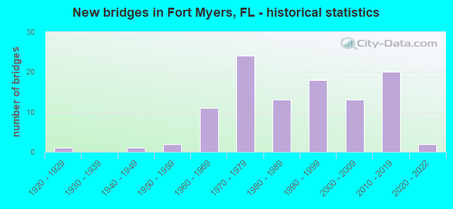
- New bridges - historical statistics
- 11920-1929
- 11940-1949
- 21950-1959
- 111960-1969
- 241970-1979
- 131980-1989
- 181990-1999
- 132000-2009
- 202010-2019
- 22020-2022

- Reconstructed bridges - Historical Statistics
- 21970-1979
- 11980-1989
- 11990-1999
- 102000-2009
- 42010-2019


- Bridge Condition - Deck
- 1.9%Excellent
- 16.7%Very good
- 72.2%Good
- 7.4%Satisfactory
- 1.9%Fair

- Bridge Condition - Superstructure
- 16.7%Very good
- 74.1%Good
- 5.6%Satisfactory
- 3.7%Fair

- Bridge Condition - Substructure
- 25.9%Very good
- 72.2%Good
- 1.9%Satisfactory

- Bridge Condition - Channel
- 1.8%Excellent
- 10.7%Very good
- 75.0%Good
- 10.7%Satisfactory
- 1.8%Fair

- Bridge Condition - Culverts
- 18.2%Very good
- 77.3%Good
- 4.5%Fair
Find on map >> Show street view
Structure Number: 34176, Location: 1.0MI SOUTH OF SR 865 (Lat: 26.291000, Lng: -81.818569), Route carried "on" structure: County highway 901, Year Built: 2010, Status: Open, Structure Length: 8.58m (28.15ft), Average Daily Traffic: 7,100 (year 2022), Truck Traffic: 5%, Average Future Daily Traffic: 8,500 (year 2042), Design Load: HL 93, Features Intersected: COCOHATCHEE RIVER
Minimum Vertical Clearance: 30.45m (99.90ft), Kilometerpoint: 0.283, Lanes on structure: 2, Owner: County Highway Agency, Approaching Roadway Width: 11.3m (37.1ft), Material/Design: Prestressed concrete, Design/Construction: Slab, Number Of Spans In Main Unit: 7, Length of Maximum Span: 12.3m (40.4ft), Curb or Sidewalk Widths: Left: 3.0m (9.8ft), Right: 1.8m (5.9ft), Curb-To-Curb Width: 9.8m (32.2ft), Out-to-Out Width: 16.2m (53.1ft)
Condition: Deck: Very good, Superstructure: Very good, Substructure: Good, Channel: Excellent, Operating Rating: 62.5 metric tons, Method Used To Determine Operating Rating: Load and Resistance Factor (LRFR), Inventory Rating: 42.1 metric tons, Method Used To Determine Inventory Rating: Load and Resistance Factor (LRFR), Structural Evaluation: Better than present minimum criteria, Deck Geometry: Meets minimum limits, Waterway Adequacy: Equal to present desirable criteria, Approach Roadway Alignment: Equal to present desirable criteria, Designated Inspection Frequency: Every 24 months, Underwater Inspection Frequency: Every 24 months, Inspection Date: Febuary 2022, Underwater Inspection Date: January 2022, Deck Structure Type: Concrete Precast Panels, Wearing Surface/Protective System: Wearing Surface: Monolithic Concrete
Find on map >> Show street view
Structure Number: 120001, Location: 4.1 MI WEST OF I-75 (Lat: 26.651683, Lng: -81.856683), Route carried "on" structure: County highway 80, Year Built: 1941, Status: Open, Structure Length: 3.54m (11.61ft), Average Daily Traffic: 8,300 (year 2021), Truck Traffic: 8%, Average Future Daily Traffic: 14,400 (year 2041), Design Load: H 15, Features Intersected: Billy's Creek, Facility Carried by Structure: First Street
Minimum Vertical Clearance: 30+ m (98+ ft), Kilometerpoint: 2.129, Lanes on structure: 2, Base Highway Network: Yes, Owner: City or Municipal Highway Agency, Approaching Roadway Width: 9.1m (29.9ft), Navigation Control: Yes ( Vertical Clearance: 3.3m (10.8ft), Horizontal Clearance: 7.5m (24.6ft)), Material/Design: Steel, Design/Construction: Movable - Lift, Number Of Spans In Main Unit: 1, Number Of Approach Spans: 2, Length of Maximum Span: 12.7m (41.7ft), Curb or Sidewalk Widths: Left: 1.0m (3.3ft), Right: 1.0m (3.3ft), Curb-To-Curb Width: 9.1m (29.9ft), Out-to-Out Width: 12.6m (41.3ft)
Condition: Deck: Satisfactory, Superstructure: Fair, Substructure: Good, Channel: Good, Operating Rating: 41.2 metric tons, Method Used To Determine Operating Rating: Load Testing, Inventory Rating: 24.8 metric tons, Method Used To Determine Inventory Rating: Load Testing, Structural Evaluation: Somewhat better than minimum adequacy, Deck Geometry: Meets minimum limits, Waterway Adequacy: Better than present minimum criteria, Approach Roadway Alignment: Equal to present desirable criteria, Length Of Structure Improvement: 3.54m (11.61ft), Designated Inspection Frequency: Every 24 months, Critical Feature Inspection Frequency: Every 12 months, Underwater Inspection Frequency: Every 24 months, Other Special Inspection Frequency: Every 12 months, Inspection Date: October 2020, Critical Feature Inspection Date: October 2021, Underwater Inspection Date: September 2020, Other Special Inspection Date: October 2021, Bridge Improvement Cost: $32,000, Roadway Improvement Cost: $3,000, Total Project Cost: $35,000, Deck Structure Type: Concrete Cast-file-Place
Find on map >> Show street view
Structure Number: 120002, Location: 2.3MI SOUTH OF SR-78 (Lat: 26.649092, Lng: -81.876914), Route carried "on" structure: US 41, Year Built: 1962, Status: Open, Structure Length: 151.36m (496.59ft), Average Daily Traffic: 42,000 (year 2022), Truck Traffic: 5%, Average Future Daily Traffic: 72,870 (year 2042), Design Load: H 10, Features Intersected: CALOOSA RVR & W 1ST ST.
Minimum Vertical Clearance: 5.58m (18.31ft), Kilometerpoint: 38.092, Lanes on structure: 4, Lanes under structure: 3, Base Highway Network: Yes, Owner: State Highway Agency, Approaching Roadway Width: 16.0m (52.5ft), Skew: 39 degrees, Navigation Control: Yes ( Vertical Clearance: 16.7m (54.8ft), Horizontal Clearance: 32.0m (105.0ft)), Material/Design: Steel continuous, Design/Construction: Stringer/Multi-beam, Number Of Spans In Main Unit: 3, Number Of Approach Spans: 73, Length of Maximum Span: 39.6m (129.9ft), Curb or Sidewalk Widths: Left: 0.6m (2.0ft), Right: 0.6m (2.0ft), Curb-To-Curb Width: 16.0m (52.5ft), Out-to-Out Width: 18.9m (62.0ft)
Condition: Deck: Satisfactory, Superstructure: Good, Substructure: Good, Channel: Good, Operating Rating: 58.1 metric tons, Method Used To Determine Operating Rating: Load Factor (LF), Inventory Rating: 35.4 metric tons, Method Used To Determine Inventory Rating: Load Factor (LF), Structural Evaluation: Better than present minimum criteria, Deck Geometry: Meets minimum limits, Underclear: Equal to present minimum criteria, Waterway Adequacy: Equal to present desirable criteria, Approach Roadway Alignment: Equal to present desirable criteria, Length Of Structure Improvement: 151.36m (496.59ft), Designated Inspection Frequency: Every 24 months, Underwater Inspection Frequency: Every 24 months, Inspection Date: Febuary 2022, Underwater Inspection Date: January 2022, Bridge Improvement Cost: $25,000, Roadway Improvement Cost: $3,000, Total Project Cost: $28,000, Deck Structure Type: Concrete Cast-file-Place
Find on map >> Show street view
Structure Number: 120005, Location: 0.25MI S/O CALOOSAHATCHEE (Lat: 26.640806, Lng: -81.872778), Route carried "on" structure: US 41, Year Built: 1962, Status: Open, Structure Length: 14.47m (47.47ft), Average Daily Traffic: 19,000 (year 2020), Truck Traffic: 4%, Average Future Daily Traffic: 32,965 (year 2042), Design Load: H 20, Features Intersected: SR-80 SR-82 SR-867
Minimum Vertical Clearance: 30+ m (98+ ft), Kilometerpoint: 37.844, Lanes on structure: 2, Lanes under structure: 5, Base Highway Network: Yes, Owner: State Highway Agency, Approaching Roadway Width: 8.6m (28.2ft), Skew: 9 degrees, Material/Design: Prestressed concrete, Design/Construction: Stringer/Multi-beam, Number Of Spans In Main Unit: 6, Length of Maximum Span: 32.2m (105.6ft), Curb or Sidewalk Widths: Left: 0.6m (2.0ft), Right: 0.6m (2.0ft), Curb-To-Curb Width: 8.6m (28.2ft), Out-to-Out Width: 10.4m (34.1ft)
Condition: Deck: Satisfactory, Superstructure: Good, Substructure: Good, Operating Rating: 54.9 metric tons, Method Used To Determine Operating Rating: Load and Resistance Factor (LRFR), Inventory Rating: 42.4 metric tons, Method Used To Determine Inventory Rating: Load and Resistance Factor (LRFR), Structural Evaluation: Better than present minimum criteria, Deck Geometry: High priority of corrective action, Underclear: Somewhat better than minimum adequacy, Approach Roadway Alignment: Equal to present desirable criteria, Designated Inspection Frequency: Every 24 months, Inspection Date: July 2020, Deck Structure Type: Concrete Cast-file-Place
Find on map >> Show street view
Structure Number: 120006, Location: 540 FT S OF SR-884 (Lat: 26.595244, Lng: -81.871872), Route carried "on" structure: US 41, Year Built: 1964, Year Reconstructed: 1981, Status: Open, Structure Length: 0.68m (2.23ft), Average Daily Traffic: 42,000 (year 2020), Truck Traffic: 4%, Average Future Daily Traffic: 72,870 (year 2042), Design Load: H 10, Features Intersected: KELLYS CANAL
Minimum Vertical Clearance: 30+ m (98+ ft), Kilometerpoint: 32.864, Lanes on structure: 8, Base Highway Network: Yes, Owner: State Highway Agency, Approaching Roadway Width: 32.8m (107.6ft), Skew: 20 degrees, Material/Design: Concrete, Design/Construction: Culvert, Number Of Spans In Main Unit: 3, Length of Maximum Span: 2.1m (6.9ft)
Condition: Channel: Satisfactory, Culverts: Good, Operating Rating: 51.7 metric tons, Method Used To Determine Operating Rating: Load Factor (LF), Inventory Rating: 30.8 metric tons, Method Used To Determine Inventory Rating: Load Factor (LF), Structural Evaluation: Better than present minimum criteria, Waterway Adequacy: Equal to present desirable criteria, Approach Roadway Alignment: Equal to present desirable criteria, Designated Inspection Frequency: Every 24 months, Inspection Date: July 2020
Find on map >> Show street view
Structure Number: 120007, Location: 1.9MI S OF SR-82 (Lat: 26.611500, Lng: -81.872000), Route carried "on" structure: US 41, Year Built: 1962, Status: Open, Structure Length: 0.86m (2.82ft), Average Daily Traffic: 38,000 (year 2020), Truck Traffic: 4%, Average Future Daily Traffic: 65,930 (year 2042), Design Load: H 10, Features Intersected: COUNTRY CLUB CANAL
Minimum Vertical Clearance: 30+ m (98+ ft), Kilometerpoint: 34.670, Lanes on structure: 6, Base Highway Network: Yes, Owner: State Highway Agency, Approaching Roadway Width: 22.4m (73.5ft), Material/Design: Concrete, Design/Construction: Culvert, Number Of Spans In Main Unit: 3, Length of Maximum Span: 2.9m (9.5ft)
Condition: Channel: Good, Culverts: Good, Operating Rating: 53.5 metric tons, Method Used To Determine Operating Rating: Load Factor (LF), Inventory Rating: 31.8 metric tons, Method Used To Determine Inventory Rating: Load Factor (LF), Structural Evaluation: Better than present minimum criteria, Waterway Adequacy: Better than present minimum criteria, Approach Roadway Alignment: Equal to present desirable criteria, Designated Inspection Frequency: Every 24 months, Underwater Inspection Frequency: Every 24 months, Inspection Date: July 2020, Underwater Inspection Date: June 2020
Find on map >> Show street view
Structure Number: 120018, Location: 4.2MI N OF SR-865 (Lat: 26.576639, Lng: -81.897944), Route carried "on" structure: State highway 867, Year Built: 1967, Year Reconstructed: 1991, Status: Open, Structure Length: 4.94m (16.21ft), Average Daily Traffic: 22,000 (year 2022), Truck Traffic: 4%, Average Future Daily Traffic: 38,170 (year 2042), Design Load: H 10, Features Intersected: WHISKEY CREEK, Facility Carried by Structure: MCGREGOR BLVD.
Minimum Vertical Clearance: 30+ m (98+ ft), Kilometerpoint: 8.105, Lanes on structure: 2, Owner: State Highway Agency, Approaching Roadway Width: 11.0m (36.1ft), Skew: 9 degrees, Material/Design: Prestressed concrete, Design/Construction: Stringer/Multi-beam, Number Of Spans In Main Unit: 3, Length of Maximum Span: 16.5m (54.1ft), Curb or Sidewalk Widths: Left: 2.4m (7.9ft), Right: 0.0m, Curb-To-Curb Width: 12.0m (39.4ft), Out-to-Out Width: 15.5m (50.9ft)
Condition: Deck: Good, Superstructure: Good, Substructure: Good, Channel: Good, Operating Rating: 51.7 metric tons, Method Used To Determine Operating Rating: Allowable Stress (AS), Inventory Rating: 45.4 metric tons, Method Used To Determine Inventory Rating: Allowable Stress (AS), Structural Evaluation: Better than present minimum criteria, Deck Geometry: Somewhat better than minimum adequacy, Waterway Adequacy: Equal to present desirable criteria, Approach Roadway Alignment: Better than present minimum criteria, Designated Inspection Frequency: Every 24 months, Underwater Inspection Frequency: Every 24 months, Inspection Date: Febuary 2022, Underwater Inspection Date: January 2022, Deck Structure Type: Concrete Cast-file-Place
Find on map >> Show street view
Structure Number: 120069, Location: 0.5MI NORTH OF CR-884 (Lat: 26.604056, Lng: -81.887606), Route carried "on" structure: City street , Year Built: 1951, Status: Open, Structure Length: 0.67m (2.20ft), Average Daily Traffic: 15,700 (year 2021), Truck Traffic: 4%, Average Future Daily Traffic: 16,485 (year 2041), Design Load: H 10, Features Intersected: MCGREGOR GROVE CREEK, Facility Carried by Structure: MCGREGOR BLVD.
Minimum Vertical Clearance: 30+ m (98+ ft), Kilometerpoint: 11.325, Lanes on structure: 2, Owner: City or Municipal Highway Agency, Approaching Roadway Width: 10.9m (35.8ft), Skew: 2 degrees, Material/Design: Concrete, Design/Construction: Culvert, Number Of Spans In Main Unit: 2, Length of Maximum Span: 3.4m (11.2ft)
Condition: Channel: Good, Culverts: Good, Operating Rating: 39.9 metric tons, Method Used To Determine Operating Rating: Load Factor (LF), Inventory Rating: 23.6 metric tons, Method Used To Determine Inventory Rating: Load Factor (LF), Structural Evaluation: Somewhat better than minimum adequacy, Waterway Adequacy: Equal to present desirable criteria, Approach Roadway Alignment: Equal to present desirable criteria, Designated Inspection Frequency: Every 24 months, Inspection Date: October 2021
Find on map >> Show street view
Structure Number: 12007, Location: 1MI N OF CR-884 (Lat: 26.611403, Lng: -81.884611), Route carried "on" structure: City street , Year Built: 1951, Status: Open, Structure Length: 0.78m (2.56ft), Average Daily Traffic: 20,900 (year 2021), Truck Traffic: 4%, Average Future Daily Traffic: 21,945 (year 2041), Design Load: H 10, Features Intersected: COUNTRY CLUB CANAL, Facility Carried by Structure: McGREGOR BLVD
Minimum Vertical Clearance: 30+ m (98+ ft), Kilometerpoint: 12.184, Lanes on structure: 2, Owner: City or Municipal Highway Agency, Approaching Roadway Width: 7.6m (24.9ft), Skew: 2 degrees, Material/Design: Concrete, Design/Construction: Culvert, Number Of Spans In Main Unit: 2, Length of Maximum Span: 3.9m (12.8ft), Curb or Sidewalk Widths: Left: 1.5m (4.9ft), Right: 1.5m (4.9ft)
Condition: Channel: Satisfactory, Culverts: Good, Operating Rating: 39.9 metric tons, Method Used To Determine Operating Rating: Load Factor (LF), Inventory Rating: 23.6 metric tons, Method Used To Determine Inventory Rating: Load Factor (LF), Structural Evaluation: Somewhat better than minimum adequacy, Waterway Adequacy: Equal to present desirable criteria, Approach Roadway Alignment: Equal to present desirable criteria, Designated Inspection Frequency: Every 24 months, Inspection Date: October 2021
Find on map >> Show street view
Structure Number: 120077, Location: 1MI EAST OF US-41/SR-45 (Lat: 26.597219, Lng: -81.855539), Route carried "on" structure: State highway 884, Year Built: 1976, Status: Open, Structure Length: 2.59m (8.50ft), Average Daily Traffic: 54,000 (year 2022), Truck Traffic: 5%, Average Future Daily Traffic: 93,690 (year 2042), Design Load: HS 20+Mod, Features Intersected: TEN MILE CANAL
Minimum Vertical Clearance: 30+ m (98+ ft), Kilometerpoint: 3.484, Lanes on structure: 6, Base Highway Network: Yes, Owner: State Highway Agency, Approaching Roadway Width: 26.5m (86.9ft), Skew: 20 degrees, Material/Design: Concrete continuous, Design/Construction: Slab, Number Of Spans In Main Unit: 3, Length of Maximum Span: 8.7m (28.5ft), Curb-To-Curb Width: 26.5m (86.9ft), Out-to-Out Width: 27.1m (88.9ft)
Condition: Deck: Good, Superstructure: Good, Substructure: Good, Channel: Good, Operating Rating: 58.3 metric tons, Method Used To Determine Operating Rating: Load Factor (LF), Inventory Rating: 34.9 metric tons, Method Used To Determine Inventory Rating: Load Factor (LF), Structural Evaluation: Better than present minimum criteria, Deck Geometry: Equal to present minimum criteria, Waterway Adequacy: Equal to present desirable criteria, Approach Roadway Alignment: Equal to present desirable criteria, Designated Inspection Frequency: Every 24 months, Underwater Inspection Frequency: Every 24 months, Inspection Date: Febuary 2022, Underwater Inspection Date: January 2022, Deck Structure Type: Concrete Cast-file-Place
Find on map >> Show street view
Structure Number: 120083, Location: 0.6MI NORTH OF SR-80 (Lat: 26.697336, Lng: -81.799483), Route carried "on" structure: Interstate 75, Year Built: 1976, Year Reconstructed: 2015, Status: Open, Structure Length: 117.58m (385.76ft), Average Daily Traffic: 35,000 (year 2020), Truck Traffic: 14%, Average Future Daily Traffic: 60,725 (year 2042), Design Load: HS 20, Features Intersected: CALOOSAHATCHEE RIVER
Minimum Vertical Clearance: 30+ m (98+ ft), Kilometerpoint: 42.675, Lanes on structure: 4, Base Highway Network: Yes, Owner: State Highway Agency, Approaching Roadway Width: 20.6m (67.6ft), Navigation Control: Yes ( Vertical Clearance: 16.6m (54.5ft), Horizontal Clearance: 31.8m (104.3ft)), Material/Design: Steel continuous, Design/Construction: Stringer/Multi-beam, Number Of Spans In Main Unit: 3, Number Of Approach Spans: 59, Length of Maximum Span: 51.6m (169.3ft), Curb-To-Curb Width: 20.6m (67.6ft), Out-to-Out Width: 21.5m (70.5ft)
Condition: Deck: Good, Superstructure: Good, Substructure: Good, Channel: Good, Operating Rating: 40.5 metric tons, Method Used To Determine Operating Rating: Load and Resistance Factor (LRFR), Inventory Rating: 33.9 metric tons, Method Used To Determine Inventory Rating: Load and Resistance Factor (LRFR), Structural Evaluation: Better than present minimum criteria, Deck Geometry: Equal to present minimum criteria, Waterway Adequacy: Equal to present desirable criteria, Approach Roadway Alignment: Equal to present desirable criteria, Length Of Structure Improvement: 118.30m (388.12ft), Designated Inspection Frequency: Every 24 months, Underwater Inspection Frequency: Every 24 months, Inspection Date: March 2020, Underwater Inspection Date: Febuary 2020, Bridge Improvement Cost: $106,000, Roadway Improvement Cost: $5,000, Total Project Cost: $121,000, Deck Structure Type: Concrete Cast-file-Place
Find on map >> Show street view
Structure Number: 120084, Location: 0.6MI NORTH OF SR-80 (Lat: 26.697375, Lng: -81.799122), Route carried "on" structure: Interstate 75, Year Built: 1976, Year Reconstructed: 2015, Status: Open, Structure Length: 119.00m (390.42ft), Average Daily Traffic: 35,000 (year 2020), Truck Traffic: 14%, Average Future Daily Traffic: 60,725 (year 2042), Design Load: HS 20, Features Intersected: CALOOSAHATCHEE RIVER
Minimum Vertical Clearance: 30+ m (98+ ft), Kilometerpoint: 42.675, Lanes on structure: 4, Base Highway Network: Yes, Owner: State Highway Agency, Approaching Roadway Width: 20.6m (67.6ft), Navigation Control: Yes ( Vertical Clearance: 16.6m (54.5ft), Horizontal Clearance: 31.8m (104.3ft)), Material/Design: Steel continuous, Design/Construction: Stringer/Multi-beam, Number Of Spans In Main Unit: 3, Number Of Approach Spans: 59, Length of Maximum Span: 51.6m (169.3ft), Curb-To-Curb Width: 20.6m (67.6ft), Out-to-Out Width: 21.5m (70.5ft)
Condition: Deck: Good, Superstructure: Good, Substructure: Good, Channel: Good, Operating Rating: 40.5 metric tons, Method Used To Determine Operating Rating: Load and Resistance Factor (LRFR), Inventory Rating: 33.9 metric tons, Method Used To Determine Inventory Rating: Load and Resistance Factor (LRFR), Structural Evaluation: Better than present minimum criteria, Deck Geometry: Equal to present minimum criteria, Waterway Adequacy: Equal to present desirable criteria, Approach Roadway Alignment: Equal to present desirable criteria, Length Of Structure Improvement: 118.30m (388.12ft), Designated Inspection Frequency: Every 24 months, Underwater Inspection Frequency: Every 24 months, Inspection Date: March 2020, Underwater Inspection Date: Febuary 2020, Bridge Improvement Cost: $106,000, Roadway Improvement Cost: $5,000, Total Project Cost: $121,000, Deck Structure Type: Concrete Cast-file-Place
Find on map >> Show street view
Structure Number: 120088, Location: SR-865 AT FT MYERS BEACH (Lat: 26.457336, Lng: -81.953650), Route carried "on" structure: State highway 685, Year Built: 1980, Status: Open, Structure Length: 64.10m (210.30ft), Average Daily Traffic: 21,500 (year 2022), Truck Traffic: 6%, Average Future Daily Traffic: 37,302 (year 2042), Design Load: HS 20, Features Intersected: MATANZAS PASS, Facility Carried by Structure: SR-865
Minimum Vertical Clearance: 30+ m (98+ ft), Kilometerpoint: 0.222, Lanes on structure: 3, Lanes under structure: 7, Owner: State Highway Agency, Approaching Roadway Width: 12.1m (39.7ft), Skew: 1 degrees, Navigation Control: Yes ( Vertical Clearance: 19.8m (65.0ft), Horizontal Clearance: 25.0m (82.0ft)), Material/Design: Prestressed concrete, Design/Construction: Stringer/Multi-beam, Number Of Spans In Main Unit: 22, Length of Maximum Span: 36.6m (120.1ft), Curb or Sidewalk Widths: Left: 0.0m, Right: 1.8m (5.9ft), Curb-To-Curb Width: 12.1m (39.7ft), Out-to-Out Width: 15.0m (49.2ft)
Condition: Deck: Satisfactory, Superstructure: Good, Substructure: Good, Channel: Good, Operating Rating: 78.8 metric tons, Method Used To Determine Operating Rating: Load Factor (LF), Inventory Rating: 52.9 metric tons, Method Used To Determine Inventory Rating: Load Factor (LF), Structural Evaluation: Better than present minimum criteria, Deck Geometry: Meets minimum limits, Underclear: Superior to present desirable criteria, Waterway Adequacy: Equal to present desirable criteria, Approach Roadway Alignment: Equal to present desirable criteria, Designated Inspection Frequency: Every 24 months, Underwater Inspection Frequency: Every 24 months, Inspection Date: Febuary 2022, Underwater Inspection Date: January 2022, Deck Structure Type: Concrete Precast Panels
Find on map >> Show street view
Structure Number: 12009, Location: 1.8 Mi. S of SR-80 (Lat: 26.656372, Lng: -81.799628), Route carried "on" structure: Interstate 75, Year Built: 1978, Year Reconstructed: 2013, Status: Open, Structure Length: 5.86m (19.23ft), Average Daily Traffic: 42,000 (year 2021), Truck Traffic: 15%, Average Future Daily Traffic: 52,500 (year 2041), Design Load: HS 20, Features Intersected: LUCKETT ROAD
Minimum Vertical Clearance: 30+ m (98+ ft), Kilometerpoint: 38.727, Lanes on structure: 3, Lanes under structure: 4, Base Highway Network: Yes, Owner: State Highway Agency, Approaching Roadway Width: 16.9m (55.4ft), Material/Design: Prestressed concrete, Design/Construction: Stringer/Multi-beam, Number Of Spans In Main Unit: 3, Length of Maximum Span: 33.1m (108.6ft), Curb-To-Curb Width: 16.9m (55.4ft), Out-to-Out Width: 18.0m (59.1ft)
Condition: Deck: Good, Superstructure: Good, Substructure: Good, Operating Rating: 61.7 metric tons, Method Used To Determine Operating Rating: Load Factor (LF), Inventory Rating: 36.5 metric tons, Method Used To Determine Inventory Rating: Load Factor (LF), Structural Evaluation: Better than present minimum criteria, Deck Geometry: Equal to present minimum criteria, Underclear: Better than present minimum criteria, Approach Roadway Alignment: Equal to present desirable criteria, Designated Inspection Frequency: Every 24 months, Inspection Date: June 2021, Deck Structure Type: Concrete Cast-file-Place
Find on map >> Show street view
Structure Number: 120091, Location: 1.8 Mi. S of SR-80 (Lat: 26.656378, Lng: -81.799353), Route carried "on" structure: Interstate 75, Year Built: 1978, Year Reconstructed: 2013, Status: Open, Structure Length: 5.86m (19.23ft), Average Daily Traffic: 4,200 (year 2021), Truck Traffic: 15%, Average Future Daily Traffic: 5,250 (year 2041), Design Load: HS 20, Features Intersected: LUCKETT ROAD
Minimum Vertical Clearance: 30+ m (98+ ft), Kilometerpoint: 38.732, Lanes on structure: 3, Lanes under structure: 4, Base Highway Network: Yes, Owner: State Highway Agency, Approaching Roadway Width: 16.9m (55.4ft), Material/Design: Prestressed concrete, Design/Construction: Stringer/Multi-beam, Number Of Spans In Main Unit: 3, Length of Maximum Span: 33.1m (108.6ft), Curb-To-Curb Width: 16.9m (55.4ft), Out-to-Out Width: 18.0m (59.1ft)
Condition: Deck: Very good, Superstructure: Good, Substructure: Good, Operating Rating: 61.7 metric tons, Method Used To Determine Operating Rating: Load Factor (LF), Inventory Rating: 36.5 metric tons, Method Used To Determine Inventory Rating: Load Factor (LF), Structural Evaluation: Better than present minimum criteria, Deck Geometry: Equal to present minimum criteria, Underclear: Better than present minimum criteria, Approach Roadway Alignment: Equal to present desirable criteria, Designated Inspection Frequency: Every 24 months, Inspection Date: June 2021, Deck Structure Type: Concrete Cast-file-Place
Find on map >> Show street view
Structure Number: 120106, Location: 6.2 MI S/O SR-82 (Lat: 26.547294, Lng: -81.795144), Route carried "on" structure: Interstate 75, Year Built: 1979, Year Reconstructed: 2010, Status: Open, Structure Length: 7.32m (24.02ft), Average Daily Traffic: 43,750 (year 2021), Truck Traffic: 13%, Average Future Daily Traffic: 54,688 (year 2041), Design Load: HL 93, Features Intersected: SR-876 (DANIELS PKWY)
Minimum Vertical Clearance: 30+ m (98+ ft), Kilometerpoint: 26.392, Lanes on structure: 3, Lanes under structure: 7, Base Highway Network: Yes, Owner: State Highway Agency, Approaching Roadway Width: 17.3m (56.8ft), Material/Design: Prestressed concrete, Design/Construction: Stringer/Multi-beam, Number Of Spans In Main Unit: 4, Length of Maximum Span: 22.5m (73.8ft), Curb-To-Curb Width: 17.3m (56.8ft), Out-to-Out Width: 18.2m (59.7ft)
Condition: Deck: Good, Superstructure: Good, Substructure: Very good, Operating Rating: 44.1 metric tons, Method Used To Determine Operating Rating: Load and Resistance Factor (LRFR), Inventory Rating: 37.6 metric tons, Method Used To Determine Inventory Rating: Load and Resistance Factor (LRFR), Structural Evaluation: Better than present minimum criteria, Deck Geometry: Better than present minimum criteria, Underclear: High priority of corrective action, Approach Roadway Alignment: Equal to present desirable criteria, Designated Inspection Frequency: Every 24 months, Inspection Date: June 2021, Deck Structure Type: Concrete Cast-file-Place
Find on map >> Show street view
Structure Number: 120107, Location: 6.2 MI S OF SR-82 (Lat: 26.547286, Lng: -81.794817), Route carried "on" structure: Interstate 75, Year Built: 1979, Year Reconstructed: 2010, Status: Open, Structure Length: 7.32m (24.02ft), Average Daily Traffic: 88,500 (year 2021), Truck Traffic: 13%, Average Future Daily Traffic: 94,088 (year 2041), Design Load: HL 93, Features Intersected: SR-876 (DANIELS PKWY)
Minimum Vertical Clearance: 30+ m (98+ ft), Kilometerpoint: 26.392, Lanes on structure: 4, Lanes under structure: 7, Base Highway Network: Yes, Owner: State Highway Agency, Approaching Roadway Width: 19.4m (63.6ft), Material/Design: Prestressed concrete, Design/Construction: Stringer/Multi-beam, Number Of Spans In Main Unit: 4, Length of Maximum Span: 22.5m (73.8ft), Curb-To-Curb Width: 19.4m (63.6ft), Out-to-Out Width: 20.3m (66.6ft)
Condition: Deck: Good, Superstructure: Good, Substructure: Good, Operating Rating: 45.7 metric tons, Method Used To Determine Operating Rating: Load and Resistance Factor (LRFR), Inventory Rating: 38.6 metric tons, Method Used To Determine Inventory Rating: Load and Resistance Factor (LRFR), Structural Evaluation: Better than present minimum criteria, Deck Geometry: Somewhat better than minimum adequacy, Underclear: Somewhat better than minimum adequacy, Approach Roadway Alignment: Equal to present desirable criteria, Designated Inspection Frequency: Every 24 months, Inspection Date: June 2021, Deck Structure Type: Concrete Cast-file-Place
Find on map >> Show street view
Structure Number: 120118, Location: 2.3 mi. S/O SR 82 (Lat: 26.602928, Lng: -81.800486), Route carried "on" structure: Interstate 75, Year Built: 1978, Year Reconstructed: 2009, Status: Open, Structure Length: 3.69m (12.11ft), Average Daily Traffic: 43,750 (year 2021), Truck Traffic: 15%, Average Future Daily Traffic: 54,688 (year 2041), Design Load: HL 93, Features Intersected: SIX MILE CYPRESS SLOUGH
Minimum Vertical Clearance: 30+ m (98+ ft), Kilometerpoint: 32.697, Lanes on structure: 3, Base Highway Network: Yes, Owner: State Highway Agency, Approaching Roadway Width: 17.4m (57.1ft), Material/Design: Concrete continuous, Design/Construction: Slab, Number Of Spans In Main Unit: 4, Length of Maximum Span: 9.4m (30.8ft), Curb-To-Curb Width: 17.4m (57.1ft), Out-to-Out Width: 18.0m (59.1ft)
Condition: Deck: Fair, Superstructure: Fair, Substructure: Good, Channel: Good, Operating Rating: 44.5 metric tons, Method Used To Determine Operating Rating: Load and Resistance Factor (LRFR), Inventory Rating: 34.3 metric tons, Method Used To Determine Inventory Rating: Load and Resistance Factor (LRFR), Structural Evaluation: Somewhat better than minimum adequacy, Deck Geometry: Better than present minimum criteria, Waterway Adequacy: Equal to present desirable criteria, Approach Roadway Alignment: Equal to present desirable criteria, Designated Inspection Frequency: Every 24 months, Inspection Date: June 2021, Deck Structure Type: Concrete Cast-file-Place
Find on map >> Show street view
Structure Number: 120119, Location: 2.3 MI. S/O SR 82 (Lat: 26.602958, Lng: -81.800147), Route carried "on" structure: Interstate 75, Year Built: 1978, Year Reconstructed: 2009, Status: Open, Structure Length: 3.69m (12.11ft), Average Daily Traffic: 43,750 (year 2021), Truck Traffic: 15%, Average Future Daily Traffic: 54,688 (year 2041), Design Load: HL 93, Features Intersected: SIX MILE CYPRESS SLOUGH
Minimum Vertical Clearance: 30+ m (98+ ft), Kilometerpoint: 32.697, Lanes on structure: 3, Base Highway Network: Yes, Owner: State Highway Agency, Approaching Roadway Width: 17.4m (57.1ft), Material/Design: Concrete continuous, Design/Construction: Slab, Number Of Spans In Main Unit: 4, Length of Maximum Span: 9.2m (30.2ft), Curb-To-Curb Width: 17.4m (57.1ft), Out-to-Out Width: 18.0m (59.1ft)
Condition: Deck: Good, Superstructure: Good, Substructure: Good, Channel: Good, Operating Rating: 44.5 metric tons, Method Used To Determine Operating Rating: Load and Resistance Factor (LRFR), Inventory Rating: 34.3 metric tons, Method Used To Determine Inventory Rating: Load and Resistance Factor (LRFR), Structural Evaluation: Better than present minimum criteria, Deck Geometry: Better than present minimum criteria, Waterway Adequacy: Equal to present desirable criteria, Approach Roadway Alignment: Equal to present desirable criteria, Designated Inspection Frequency: Every 24 months, Inspection Date: June 2021, Deck Structure Type: Concrete Cast-file-Place
Find on map >> Show street view
Structure Number: 12012, Location: 1.6MI South of SR-82 (Lat: 26.612836, Lng: -81.803386), Route carried "on" structure: Interstate 75, Year Built: 1978, Year Reconstructed: 2011, Status: Open, Structure Length: 8.71m (28.58ft), Average Daily Traffic: 43,750 (year 2021), Truck Traffic: 15%, Average Future Daily Traffic: 54,688 (year 2041), Design Load: HS 20, Features Intersected: SR-884 (COLONIAL BLVD.)
Minimum Vertical Clearance: 30+ m (98+ ft), Kilometerpoint: 33.809, Lanes on structure: 3, Lanes under structure: 9, Base Highway Network: Yes, Owner: State Highway Agency, Approaching Roadway Width: 16.9m (55.4ft), Skew: 1 degrees, Material/Design: Prestressed concrete, Design/Construction: Stringer/Multi-beam, Number Of Spans In Main Unit: 4, Length of Maximum Span: 31.4m (103.0ft), Curb-To-Curb Width: 16.9m (55.4ft), Out-to-Out Width: 18.0m (59.1ft)
Condition: Deck: Good, Superstructure: Good, Substructure: Good, Operating Rating: 43.7 metric tons, Method Used To Determine Operating Rating: Load Factor (LF), Inventory Rating: 33.7 metric tons, Method Used To Determine Inventory Rating: Load Factor (LF), Structural Evaluation: Better than present minimum criteria, Deck Geometry: Equal to present minimum criteria, Underclear: Somewhat better than minimum adequacy, Approach Roadway Alignment: Equal to present desirable criteria, Designated Inspection Frequency: Every 24 months, Inspection Date: June 2021, Deck Structure Type: Concrete Cast-file-Place
Find on map >> Show street view
Structure Number: 120121, Location: 1.6 Mi. S of SR-82 (Lat: 26.612856, Lng: -81.803069), Route carried "on" structure: Interstate 75, Year Built: 1978, Year Reconstructed: 2011, Status: Open, Structure Length: 8.71m (28.58ft), Average Daily Traffic: 43,750 (year 2021), Truck Traffic: 15%, Average Future Daily Traffic: 54,688 (year 2041), Design Load: HS 20, Features Intersected: SR-884 (COLONIAL BLVD)
Minimum Vertical Clearance: 30+ m (98+ ft), Kilometerpoint: 33.803, Lanes on structure: 4, Lanes under structure: 9, Base Highway Network: Yes, Owner: State Highway Agency, Approaching Roadway Width: 19.6m (64.3ft), Skew: 1 degrees, Material/Design: Prestressed concrete, Design/Construction: Stringer/Multi-beam, Number Of Spans In Main Unit: 4, Length of Maximum Span: 31.4m (103.0ft), Curb-To-Curb Width: 19.6m (64.3ft), Out-to-Out Width: 20.4m (66.9ft)
Condition: Deck: Good, Superstructure: Good, Substructure: Good, Operating Rating: 43.7 metric tons, Method Used To Determine Operating Rating: Load Factor (LF), Inventory Rating: 33.0 metric tons, Method Used To Determine Inventory Rating: Load Factor (LF), Structural Evaluation: Better than present minimum criteria, Deck Geometry: Somewhat better than minimum adequacy, Underclear: Somewhat better than minimum adequacy, Approach Roadway Alignment: Equal to present desirable criteria, Designated Inspection Frequency: Every 24 months, Inspection Date: June 2021, Deck Structure Type: Concrete Cast-file-Place
Find on map >> Show street view
Structure Number: 120122, Location: 3.4 Mi. S of SR-80 (Lat: 26.635006, Lng: -81.803019), Route carried "on" structure: Interstate 75, Year Built: 1978, Year Reconstructed: 2011, Status: Open, Structure Length: 8.08m (26.51ft), Average Daily Traffic: 44,250 (year 2021), Truck Traffic: 14%, Average Future Daily Traffic: 55,313 (year 2041), Design Load: HL 93, Features Intersected: SR-82 (MLK BLVD)
Minimum Vertical Clearance: 30+ m (98+ ft), Kilometerpoint: 36.312, Lanes on structure: 3, Lanes under structure: 9, Base Highway Network: Yes, Owner: State Highway Agency, Approaching Roadway Width: 17.1m (56.1ft), Material/Design: Prestressed concrete, Design/Construction: Stringer/Multi-beam, Number Of Spans In Main Unit: 4, Length of Maximum Span: 26.8m (87.9ft), Curb-To-Curb Width: 17.1m (56.1ft), Out-to-Out Width: 18.0m (59.1ft)
Condition: Deck: Very good, Superstructure: Good, Substructure: Very good, Operating Rating: 51.3 metric tons, Method Used To Determine Operating Rating: Load and Resistance Factor (LRFR), Inventory Rating: 39.6 metric tons, Method Used To Determine Inventory Rating: Load and Resistance Factor (LRFR), Structural Evaluation: Better than present minimum criteria, Deck Geometry: Equal to present minimum criteria, Underclear: Better than present minimum criteria, Approach Roadway Alignment: Equal to present desirable criteria, Designated Inspection Frequency: Every 24 months, Inspection Date: June 2021, Deck Structure Type: Concrete Cast-file-Place
Find on map >> Show street view
Structure Number: 120123, Location: 3.4MI S of SR-80 (Lat: 26.634925, Lng: -81.802714), Route carried "on" structure: Interstate 75, Year Built: 1978, Year Reconstructed: 2011, Status: Open, Structure Length: 8.08m (26.51ft), Average Daily Traffic: 44,250 (year 2021), Truck Traffic: 14%, Average Future Daily Traffic: 55,313 (year 2041), Design Load: HL 93, Features Intersected: SR-82 (MLK BLVD)
Minimum Vertical Clearance: 30+ m (98+ ft), Kilometerpoint: 36.312, Lanes on structure: 3, Lanes under structure: 6, Base Highway Network: Yes, Owner: State Highway Agency, Approaching Roadway Width: 17.1m (56.1ft), Material/Design: Prestressed concrete, Design/Construction: Stringer/Multi-beam, Number Of Spans In Main Unit: 4, Length of Maximum Span: 26.8m (87.9ft), Curb-To-Curb Width: 17.1m (56.1ft), Out-to-Out Width: 18.0m (59.1ft)
Condition: Deck: Very good, Superstructure: Good, Substructure: Very good, Operating Rating: 51.3 metric tons, Method Used To Determine Operating Rating: Load and Resistance Factor (LRFR), Inventory Rating: 39.6 metric tons, Method Used To Determine Inventory Rating: Load and Resistance Factor (LRFR), Structural Evaluation: Better than present minimum criteria, Deck Geometry: Equal to present minimum criteria, Underclear: High priority of corrective action, Approach Roadway Alignment: Equal to present desirable criteria, Designated Inspection Frequency: Every 24 months, Inspection Date: June 2021, Deck Structure Type: Concrete Cast-file-Place
Find on map >> Show street view
Structure Number: 120157, Location: 650FT NORTH OF SR-80 (Lat: 26.652528, Lng: -81.866886), Route carried "on" structure: Business US 41, Year Built: 1992, Status: Open, Structure Length: 160.11m (525.30ft), Average Daily Traffic: 18,000 (year 2021), Truck Traffic: 8%, Average Future Daily Traffic: 31,230 (year 2041), Design Load: HS 20+Mod, Features Intersected: Caloosahatchee River
Minimum Vertical Clearance: 30+ m (98+ ft), Kilometerpoint: 2.076, Lanes on structure: 3, Base Highway Network: Yes, Owner: State Highway Agency, Approaching Roadway Width: 14.6m (47.9ft), Navigation Control: Yes ( Vertical Clearance: 17.0m (55.8ft), Horizontal Clearance: 27.4m (89.9ft)), Material/Design: Prestressed concrete continuous, Design/Construction: Stringer/Multi-beam, Number Of Spans In Main Unit: 36, Number Of Approach Spans: 3, Length of Maximum Span: 43.6m (143.0ft), Curb-To-Curb Width: 17.0m (55.8ft), Out-to-Out Width: 18.0m (59.1ft)
Condition: Deck: Good, Superstructure: Good, Substructure: Good, Channel: Good, Operating Rating: 45.8 metric tons, Method Used To Determine Operating Rating: Load Factor (LF), Inventory Rating: 27.5 metric tons, Method Used To Determine Inventory Rating: Load Factor (LF), Structural Evaluation: Equal to present minimum criteria, Deck Geometry: Superior to present desirable criteria, Waterway Adequacy: Equal to present desirable criteria, Approach Roadway Alignment: Equal to present desirable criteria, Designated Inspection Frequency: Every 24 months, Underwater Inspection Frequency: Every 24 months, Inspection Date: October 2021, Underwater Inspection Date: September 2021, Deck Structure Type: Concrete Cast-file-Place, Wearing Surface/Protective System: Deck Protection: Epoxy Coated Reinforcing
Find on map >> Show street view
Structure Number: 120158, Location: 650FT NORTH OF SR-80 (Lat: 26.650606, Lng: -81.868906), Route carried "on" structure: Business US 41, Year Built: 1993, Status: Open, Structure Length: 139.49m (457.64ft), Average Daily Traffic: 16,500 (year 2021), Truck Traffic: 11%, Average Future Daily Traffic: 28,628 (year 2041), Design Load: HS 20+Mod, Features Intersected: CALOOSAHATCHEE RIVER
Minimum Vertical Clearance: 30+ m (98+ ft), Kilometerpoint: 0.249, Lanes on structure: 3, Base Highway Network: Yes (Inventory Route: 120010, Subroute: 60), Owner: State Highway Agency, Approaching Roadway Width: 16.5m (54.1ft), Navigation Control: Yes ( Vertical Clearance: 16.7m (54.8ft), Horizontal Clearance: 27.4m (89.9ft)), Material/Design: Prestressed concrete continuous, Design/Construction: Stringer/Multi-beam, Number Of Spans In Main Unit: 32, Number Of Approach Spans: 1, Length of Maximum Span: 43.6m (143.0ft), Curb or Sidewalk Widths: Left: 1.5m (4.9ft), Right: 0.0m, Curb-To-Curb Width: 17.0m (55.8ft), Out-to-Out Width: 19.7m (64.6ft)
Condition: Deck: Good, Superstructure: Good, Substructure: Good, Channel: Good, Operating Rating: 47.9 metric tons, Method Used To Determine Operating Rating: Load Factor (LF), Inventory Rating: 28.7 metric tons, Method Used To Determine Inventory Rating: Load Factor (LF), Structural Evaluation: Better than present minimum criteria, Deck Geometry: Superior to present desirable criteria, Waterway Adequacy: Superior to present desirable criteria, Approach Roadway Alignment: Equal to present desirable criteria, Designated Inspection Frequency: Every 24 months, Underwater Inspection Frequency: Every 24 months, Inspection Date: October 2021, Underwater Inspection Date: September 2021, Deck Structure Type: Concrete Cast-file-Place
Find on map >> Show street view
Structure Number: 12016, Location: 0.4MI EAST OF I-75 (Lat: 26.688294, Lng: -81.791089), Route carried "on" structure: State highway 80, Year Built: 1990, Status: Open, Structure Length: 24.38m (79.99ft), Average Daily Traffic: 33,500 (year 2021), Truck Traffic: 12%, Average Future Daily Traffic: 58,122 (year 2041), Design Load: HS 20+Mod, Features Intersected: ORANGE RIVER
Minimum Vertical Clearance: 30+ m (98+ ft), Kilometerpoint: 9.698, Lanes on structure: 6, Base Highway Network: Yes, Owner: State Highway Agency, Approaching Roadway Width: 30.7m (100.7ft), Skew: 20 degrees, Material/Design: Prestressed concrete, Design/Construction: Stringer/Multi-beam, Number Of Spans In Main Unit: 10, Length of Maximum Span: 24.6m (80.7ft), Curb or Sidewalk Widths: Left: 0.0m, Right: 1.5m (4.9ft), Curb-To-Curb Width: 34.7m (113.8ft), Out-to-Out Width: 37.5m (123.0ft)
Condition: Deck: Good, Superstructure: Good, Substructure: Good, Channel: Good, Operating Rating: 65.0 metric tons, Method Used To Determine Operating Rating: Load Factor (LF), Inventory Rating: 38.9 metric tons, Method Used To Determine Inventory Rating: Load Factor (LF), Structural Evaluation: Better than present minimum criteria, Deck Geometry: Superior to present desirable criteria, Waterway Adequacy: Equal to present desirable criteria, Approach Roadway Alignment: Equal to present desirable criteria, Designated Inspection Frequency: Every 24 months, Underwater Inspection Frequency: Every 24 months, Inspection Date: December 2021, Underwater Inspection Date: November 2021, Deck Structure Type: Concrete Cast-file-Place
Find on map >> Show street view
Structure Number: 120164, Location: 0.3MI E OF US-41 (SR-45) (Lat: 26.650725, Lng: -81.852861), Route carried "on" structure: State highway 80, Year Built: 1988, Status: Open, Structure Length: 4.27m (14.01ft), Average Daily Traffic: 11,000 (year 2021), Truck Traffic: 7%, Average Future Daily Traffic: 19,085 (year 2042), Design Load: HS 20, Features Intersected: BILLY CREEK
Minimum Vertical Clearance: 30+ m (98+ ft), Kilometerpoint: 2.070, Lanes on structure: 2, Base Highway Network: Yes, Owner: State Highway Agency, Approaching Roadway Width: 12.2m (40.0ft), Skew: 3 degrees, Material/Design: Concrete continuous, Design/Construction: Slab, Number Of Spans In Main Unit: 5, Length of Maximum Span: 9.1m (29.9ft), Curb-To-Curb Width: 12.2m (40.0ft), Out-to-Out Width: 13.0m (42.7ft)
Condition: Deck: Good, Superstructure: Good, Substructure: Good, Channel: Good, Operating Rating: 64.3 metric tons, Method Used To Determine Operating Rating: Load Factor (LF), Inventory Rating: 38.6 metric tons, Method Used To Determine Inventory Rating: Load Factor (LF), Structural Evaluation: Better than present minimum criteria, Deck Geometry: Better than present minimum criteria, Waterway Adequacy: Superior to present desirable criteria, Approach Roadway Alignment: Equal to present desirable criteria, Designated Inspection Frequency: Every 24 months, Underwater Inspection Frequency: Every 24 months, Inspection Date: December 2021, Underwater Inspection Date: November 2021, Deck Structure Type: Concrete Cast-file-Place
Find on map >> Show street view
Structure Number: 120172, Location: 2.3MI SOUTH OF CR-865 (Lat: 26.499458, Lng: -81.853903), Route carried "on" structure: US 41, Year Built: 1998, Status: Open, Structure Length: 5.18m (16.99ft), Average Daily Traffic: 46,000 (year 2020), Truck Traffic: 7%, Average Future Daily Traffic: 79,810 (year 2042), Design Load: HS 20+Mod, Features Intersected: TEN MILE CANAL
Minimum Vertical Clearance: 30+ m (98+ ft), Kilometerpoint: 21.757, Lanes on structure: 6, Base Highway Network: Yes, Owner: State Highway Agency, Approaching Roadway Width: 26.6m (87.3ft), Skew: 20 degrees, Material/Design: Prestressed concrete, Design/Construction: Stringer/Multi-beam, Number Of Spans In Main Unit: 3, Length of Maximum Span: 17.2m (56.4ft), Curb or Sidewalk Widths: Left: 2.5m (8.2ft), Right: 2.5m (8.2ft), Curb-To-Curb Width: 26.6m (87.3ft), Out-to-Out Width: 41.3m (135.5ft)
Condition: Deck: Good, Superstructure: Very good, Substructure: Good, Channel: Good, Operating Rating: 69.1 metric tons, Method Used To Determine Operating Rating: Load Factor (LF), Inventory Rating: 41.4 metric tons, Method Used To Determine Inventory Rating: Load Factor (LF), Structural Evaluation: Better than present minimum criteria, Deck Geometry: Equal to present minimum criteria, Waterway Adequacy: Superior to present desirable criteria, Approach Roadway Alignment: Equal to present desirable criteria, Designated Inspection Frequency: Every 24 months, Inspection Date: July 2020, Deck Structure Type: Concrete Cast-file-Place
Find on map >> Show street view
Structure Number: 120173, Location: 0.6 MI N/O WINKLER AVE (Lat: 26.611861, Lng: -81.854500), Route carried "on" structure: State highway 739, Year Built: 2015, Status: Open, Structure Length: 4.93m (16.17ft), Average Daily Traffic: 12,800 (year 2021), Truck Traffic: 6%, Average Future Daily Traffic: 22,208 (year 2041), Design Load: HL 93, Features Intersected: TEN MILE CANAL
Minimum Vertical Clearance: 30.45m (99.90ft), Kilometerpoint: 0.272, Lanes on structure: 6, Base Highway Network: Yes, Owner: State Highway Agency, Approaching Roadway Width: 25.9m (85.0ft), Skew: 25 degrees, Material/Design: Prestressed concrete, Design/Construction: Stringer/Multi-beam, Number Of Spans In Main Unit: 1, Length of Maximum Span: 49.3m (161.7ft), Curb or Sidewalk Widths: Left: 2.1m (6.9ft), Right: 2.1m (6.9ft), Curb-To-Curb Width: 25.9m (85.0ft), Out-to-Out Width: 36.9m (121.1ft)
Condition: Deck: Very good, Superstructure: Very good, Substructure: Very good, Channel: Very good, Operating Rating: 44.5 metric tons, Method Used To Determine Operating Rating: Load and Resistance Factor (LRFR), Inventory Rating: 38.8 metric tons, Method Used To Determine Inventory Rating: Load and Resistance Factor (LRFR), Structural Evaluation: Equal to present desirable criteria, Deck Geometry: Equal to present minimum criteria, Approach Roadway Alignment: Equal to present desirable criteria, Designated Inspection Frequency: Every 24 months, Inspection Date: November 2021, Deck Structure Type: Concrete Cast-file-Place
Find on map >> Show street view
Structure Number: 120179, Location: 0.5 MI W/O BEN HILL GRIFF (Lat: 26.511708, Lng: -81.794603), Route carried "on" structure: Other road , Year Built: 2014, Status: Open, Structure Length: 13.24m (43.44ft), Average Daily Traffic: 22,500 (year 2021), Truck Traffic: 9%, Average Future Daily Traffic: 28,125 (year 2041), Design Load: HL 93, Features Intersected: I-75, Facility Carried by Structure: SWFIA TERMINAL ACC
Minimum Vertical Clearance: 11.70m (38.39ft), Kilometerpoint: 0.000, Lanes on structure: 2, Lanes under structure: 11, Owner: State Highway Agency, Approaching Roadway Width: 24.4m (80.1ft), Skew: 30 degrees, Material/Design: Prestressed concrete, Design/Construction: Stringer/Multi-beam, Number Of Spans In Main Unit: 4, Length of Maximum Span: 40.9m (134.2ft), Curb-To-Curb Width: 24.4m (80.1ft), Out-to-Out Width: 25.9m (85.0ft)
Condition: Deck: Very good, Superstructure: Satisfactory, Substructure: Very good, Operating Rating: 38.8 metric tons, Method Used To Determine Operating Rating: Load and Resistance Factor (LRFR), Inventory Rating: 35.6 metric tons, Method Used To Determine Inventory Rating: Load and Resistance Factor (LRFR), Structural Evaluation: Equal to present minimum criteria, Deck Geometry: Superior to present desirable criteria, Underclear: Better than present minimum criteria, Approach Roadway Alignment: Equal to present minimum criteria, Designated Inspection Frequency: Every 24 months, Inspection Date: Febuary 2021, Deck Structure Type: Concrete Cast-file-Place, Wearing Surface/Protective System: Wearing Surface: Monolithic Concrete
Find on map >> Show street view
Structure Number: 12018, Location: 1MI NORTH OF ALICO RD (Lat: 26.506208, Lng: -81.850036), Route carried "on" structure: State highway 739, Year Built: 2012, Status: Open, Structure Length: 1.75m (5.74ft), Average Daily Traffic: 23,000 (year 2020), Truck Traffic: 9%, Average Future Daily Traffic: 39,905 (year 2042), Design Load: HL 93, Features Intersected: BRIARCLIFF DITCH
Minimum Vertical Clearance: 30.45m (99.90ft), Kilometerpoint: 2.290, Lanes on structure: 6, Base Highway Network: Yes, Owner: State Highway Agency, Approaching Roadway Width: 29.4m (96.5ft), Skew: 24 degrees, Material/Design: Concrete, Design/Construction: Culvert, Number Of Spans In Main Unit: 4, Length of Maximum Span: 4.3m (14.1ft)
Condition: Channel: Good, Culverts: Good, Operating Rating: 56.8 metric tons, Method Used To Determine Operating Rating: Load and Resistance Factor (LRFR), Inventory Rating: 43.7 metric tons, Method Used To Determine Inventory Rating: Load and Resistance Factor (LRFR), Structural Evaluation: Better than present minimum criteria, Waterway Adequacy: Equal to present minimum criteria, Approach Roadway Alignment: Equal to present desirable criteria, Designated Inspection Frequency: Every 24 months, Underwater Inspection Frequency: Every 24 months, Inspection Date: October 2020, Underwater Inspection Date: September 2020
Find on map >> Show street view
Structure Number: 120181, Location: 0.7MI SOUTH OF SR 865 (Lat: 26.518633, Lng: -81.853600), Route carried "on" structure: Business State highway 739, Year Built: 2012, Status: Open, Structure Length: 1.04m (3.41ft), Average Daily Traffic: 23,000 (year 2020), Truck Traffic: 9%, Average Future Daily Traffic: 39,905 (year 2042), Design Load: HL 93, Features Intersected: SIX MILE CYPRESS SLOUGH
Minimum Vertical Clearance: 30.45m (99.90ft), Kilometerpoint: 3.753, Lanes on structure: 6, Owner: State Highway Agency, Approaching Roadway Width: 30.1m (98.8ft), Skew: 21 degrees, Material/Design: Concrete, Design/Construction: Culvert, Number Of Spans In Main Unit: 3, Length of Maximum Span: 3.3m (10.8ft)
Condition: Channel: Very good, Culverts: Good, Operating Rating: 43.1 metric tons, Method Used To Determine Operating Rating: Load and Resistance Factor (LRFR), Inventory Rating: 33.3 metric tons, Method Used To Determine Inventory Rating: Load and Resistance Factor (LRFR), Structural Evaluation: Better than present minimum criteria, Waterway Adequacy: Superior to present desirable criteria, Approach Roadway Alignment: Equal to present desirable criteria, Designated Inspection Frequency: Every 24 months, Underwater Inspection Frequency: Every 24 months, Inspection Date: October 2020, Underwater Inspection Date: September 2020
Find on map >> Show street view
Structure Number: 120182, Location: 0.50 MI SOUTH OF SR-865 (Lat: 26.521831, Lng: -81.853669), Route carried "on" structure: State highway 739, Year Built: 2012, Status: Open, Structure Length: 1.52m (4.99ft), Average Daily Traffic: 23,000 (year 2020), Truck Traffic: 9%, Average Future Daily Traffic: 39,905 (year 2042), Design Load: HL 93, Features Intersected: SIX MILE CYPRESS SLOUGH
Minimum Vertical Clearance: 30.45m (99.90ft), Kilometerpoint: 4.089, Lanes on structure: 6, Base Highway Network: Yes, Owner: State Highway Agency, Approaching Roadway Width: 30.3m (99.4ft), Skew: 22 degrees, Material/Design: Concrete, Design/Construction: Culvert, Number Of Spans In Main Unit: 4, Length of Maximum Span: 3.7m (12.1ft)
Condition: Channel: Very good, Culverts: Good, Operating Rating: 49.0 metric tons, Method Used To Determine Operating Rating: Load and Resistance Factor (LRFR), Inventory Rating: 37.8 metric tons, Method Used To Determine Inventory Rating: Load and Resistance Factor (LRFR), Structural Evaluation: Better than present minimum criteria, Approach Roadway Alignment: Equal to present desirable criteria, Designated Inspection Frequency: Every 24 months, Underwater Inspection Frequency: Every 24 months, Inspection Date: October 2020, Underwater Inspection Date: September 2020
Find on map >> Show street view
Structure Number: 120183, Location: 4.5MI WEST OF I-75 (Lat: 26.596836, Lng: -81.871733), Route carried "on" structure: State highway 884, Year Built: 1997, Status: Open, Structure Length: 15.67m (51.41ft), Average Daily Traffic: 54,000 (year 2022), Truck Traffic: 5%, Average Future Daily Traffic: 93,690 (year 2042), Design Load: HS 20+Mod, Features Intersected: US-41 (SR-45)
Minimum Vertical Clearance: 30+ m (98+ ft), Kilometerpoint: 1.806, Lanes on structure: 4, Lanes under structure: 8, Base Highway Network: Yes, Owner: State Highway Agency, Approaching Roadway Width: 22.9m (75.1ft), Skew: 30 degrees, Material/Design: Steel continuous, Design/Construction: Box Beam or Girders - Single/Spread, Number Of Spans In Main Unit: 3, Length of Maximum Span: 77.1m (253.0ft), Curb-To-Curb Width: 22.9m (75.1ft), Out-to-Out Width: 24.5m (80.4ft)
Condition: Deck: Good, Superstructure: Good, Substructure: Good, Operating Rating: 43.1 metric tons, Method Used To Determine Operating Rating: Load Factor (LF), Inventory Rating: 25.8 metric tons, Method Used To Determine Inventory Rating: Load Factor (LF), Structural Evaluation: Equal to present minimum criteria, Deck Geometry: Superior to present desirable criteria, Underclear: Superior to present desirable criteria, Approach Roadway Alignment: Equal to present desirable criteria, Designated Inspection Frequency: Every 24 months, Inspection Date: Febuary 2022, Deck Structure Type: Concrete Cast-file-Place
Find on map >> Show street view
Structure Number: 120184, Location: 1MI SOUTHWEST OF US-41 (Lat: 26.629972, Lng: -81.882778), Route carried "on" structure: City street , Year Built: 1999, Status: Open, Structure Length: 0.83m (2.72ft), Average Daily Traffic: 15,700 (year 2021), Truck Traffic: 4%, Average Future Daily Traffic: 16,485 (year 2041), Design Load: HS 20, Features Intersected: MANUEL CANAL, Facility Carried by Structure: MCGREGOR BLVD
Minimum Vertical Clearance: 30+ m (98+ ft), Kilometerpoint: 14.302, Lanes on structure: 2, Owner: City or Municipal Highway Agency, Approaching Roadway Width: 11.0m (36.1ft), Material/Design: Concrete, Design/Construction: Culvert, Number Of Spans In Main Unit: 3, Length of Maximum Span: 2.9m (9.5ft)
Condition: Channel: Good, Culverts: Good, Inventory Rating: 55.2 metric tons, Method Used To Determine Inventory Rating: Load Factor (LF), Structural Evaluation: Better than present minimum criteria, Waterway Adequacy: Better than present minimum criteria, Approach Roadway Alignment: Equal to present desirable criteria, Designated Inspection Frequency: Every 24 months, Inspection Date: October 2021
Find on map >> Show street view
Structure Number: 120185, Location: 0.5 MI E of I-75 (SR-93) (Lat: 26.511806, Lng: -81.785472), Route carried "on" structure: Other road , Year Built: 2015, Status: Open, Structure Length: 5.12m (16.80ft), Average Daily Traffic: 27,500 (year 2021), Truck Traffic: 9%, Average Future Daily Traffic: 34,375 (year 2041), Design Load: HL 93, Features Intersected: BEN HILL GRIFFIN PRKY, Facility Carried by Structure: SWFIA TERMINAL ACC
Minimum Vertical Clearance: 5.33m (17.49ft), Kilometerpoint: 0.954, Lanes on structure: 4, Lanes under structure: 6, Owner: State Highway Agency, Approaching Roadway Width: 22.9m (75.1ft), Skew: 20 degrees, Material/Design: Prestressed concrete, Design/Construction: Stringer/Multi-beam, Number Of Spans In Main Unit: 1, Length of Maximum Span: 51.2m (168.0ft), Curb-To-Curb Width: 22.9m (75.1ft), Out-to-Out Width: 28.7m (94.2ft)
Condition: Deck: Very good, Superstructure: Very good, Substructure: Very good, Operating Rating: 44.1 metric tons, Method Used To Determine Operating Rating: Load and Resistance Factor (LRFR), Inventory Rating: 39.8 metric tons, Method Used To Determine Inventory Rating: Load and Resistance Factor (LRFR), Structural Evaluation: Equal to present desirable criteria, Deck Geometry: Superior to present desirable criteria, Underclear: Better than present minimum criteria, Approach Roadway Alignment: Equal to present desirable criteria, Designated Inspection Frequency: Every 24 months, Inspection Date: Febuary 2021, Deck Structure Type: Concrete Cast-file-Place, Wearing Surface/Protective System: Wearing Surface: Monolithic Concrete
Find on map >> Show street view
Structure Number: 12019, Location: 0.3 MI N/O US-41 (Lat: 26.495144, Lng: -81.843147), Route carried "on" structure: State highway 739, Year Built: 2012, Status: Open, Structure Length: 27.05m (88.75ft), Average Daily Traffic: 23,500 (year 2020), Truck Traffic: 7%, Average Future Daily Traffic: 40,772 (year 2040), Design Load: HL 93, Features Intersected: ALICO RD / SGRR
Minimum Vertical Clearance: 30.45m (99.90ft), Kilometerpoint: 0.758, Lanes on structure: 2, Lanes under structure: 5, Base Highway Network: Yes, Owner: State Highway Agency, Approaching Roadway Width: 11.8m (38.7ft), Skew: 9 degrees, Material/Design: Prestressed concrete, Design/Construction: Stringer/Multi-beam, Number Of Spans In Main Unit: 8, Length of Maximum Span: 47.2m (154.9ft), Curb-To-Curb Width: 11.8m (38.7ft), Out-to-Out Width: 14.3m (46.9ft)
Condition: Deck: Very good, Superstructure: Good, Substructure: Very good, Operating Rating: 57.5 metric tons, Method Used To Determine Operating Rating: Load and Resistance Factor (LRFR), Inventory Rating: 45.7 metric tons, Method Used To Determine Inventory Rating: Load and Resistance Factor (LRFR), Structural Evaluation: Better than present minimum criteria, Deck Geometry: Better than present minimum criteria, Underclear: Better than present minimum criteria, Approach Roadway Alignment: Equal to present desirable criteria, Designated Inspection Frequency: Every 24 months, Inspection Date: October 2020, Deck Structure Type: Concrete Cast-file-Place
Find on map >> Show street view
Structure Number: 120193, Location: 1.2 MI N/O ALICO ROAD (Lat: 26.510572, Lng: -81.795142), Route carried "on" structure: Ramp Interstate 75, Year Built: 2014, Status: Open, Structure Length: 4.45m (14.60ft), Average Daily Traffic: 28,370 (year 2020), Truck Traffic: 8%, Average Future Daily Traffic: 35,462 (year 2040), Design Load: HL 93, Features Intersected: Canal 193
Minimum Vertical Clearance: 30+ m (98+ ft), Kilometerpoint: 1.318, Lanes on structure: 3, Owner: State Highway Agency, Approaching Roadway Width: 15.8m (51.8ft), Material/Design: Prestressed concrete, Design/Construction: Stringer/Multi-beam, Number Of Spans In Main Unit: 1, Length of Maximum Span: 44.5m (146.0ft), Curb-To-Curb Width: 15.8m (51.8ft), Out-to-Out Width: 16.8m (55.1ft)
Condition: Deck: Excellent, Superstructure: Satisfactory, Substructure: Very good, Channel: Good, Operating Rating: 39.8 metric tons, Method Used To Determine Operating Rating: Load and Resistance Factor (LRFR), Inventory Rating: 35.9 metric tons, Method Used To Determine Inventory Rating: Load and Resistance Factor (LRFR), Structural Evaluation: Equal to present minimum criteria, Deck Geometry: Superior to present desirable criteria, Waterway Adequacy: Superior to present desirable criteria, Approach Roadway Alignment: Equal to present desirable criteria, Designated Inspection Frequency: Every 24 months, Inspection Date: May 2020, Deck Structure Type: Concrete Cast-file-Place, Wearing Surface/Protective System: Wearing Surface: Monolithic Concrete
Find on map >> Show street view
Structure Number: 120198, Location: 1.6MI EAST OF I-75 (Lat: 26.627058, Lng: -81.778331), Route carried "on" structure: State highway 82, Year Built: 2012, Status: Open, Structure Length: 0.64m (2.10ft), Average Daily Traffic: 38,500 (year 2020), Truck Traffic: 8%, Average Future Daily Traffic: 66,798 (year 2042), Design Load: HL 93, Features Intersected: Buckingham Canal
Minimum Vertical Clearance: 30+ m (98+ ft), Kilometerpoint: 9.661, Lanes on structure: 8, Base Highway Network: Yes, Owner: State Highway Agency, Approaching Roadway Width: 30.5m (100.1ft), Material/Design: Concrete, Design/Construction: Culvert, Number Of Spans In Main Unit: 2, Length of Maximum Span: 3.0m (9.8ft), Curb or Sidewalk Widths: Left: 1.5m (4.9ft), Right: 1.5m (4.9ft)
Condition: Channel: Good, Culverts: Very good, Operating Rating: 42.8 metric tons, Method Used To Determine Operating Rating: Load and Resistance Factor (LRFR), Inventory Rating: 33.0 metric tons, Method Used To Determine Inventory Rating: Load and Resistance Factor (LRFR), Structural Evaluation: Equal to present desirable criteria, Waterway Adequacy: Somewhat better than minimum adequacy, Approach Roadway Alignment: Equal to present desirable criteria, Designated Inspection Frequency: Every 24 months, Underwater Inspection Frequency: Every 24 months, Inspection Date: March 2020, Underwater Inspection Date: March 2020
Find on map >> Show street view
Structure Number: 120199, Location: 0.6 MI N/O WINKLER AVE (Lat: 26.612181, Lng: -81.855261), Route carried "on" structure: State highway 739, Year Built: 2015, Status: Open, Structure Length: 12.56m (41.21ft), Average Daily Traffic: 12,800 (year 2021), Truck Traffic: 6%, Average Future Daily Traffic: 22,208 (year 2041), Design Load: HL 93, Features Intersected: PALM AVE & SGRR
Minimum Vertical Clearance: 30.45m (99.90ft), Kilometerpoint: 0.381, Lanes on structure: 6, Lanes under structure: 2, Base Highway Network: Yes, Owner: State Highway Agency, Approaching Roadway Width: 26.2m (86.0ft), Skew: 24 degrees, Material/Design: Prestressed concrete, Design/Construction: Stringer/Multi-beam, Number Of Spans In Main Unit: 3, Length of Maximum Span: 51.8m (169.9ft), Curb or Sidewalk Widths: Left: 2.0m (6.6ft), Right: 2.0m (6.6ft), Curb-To-Curb Width: 26.2m (86.0ft), Out-to-Out Width: 36.9m (121.1ft)
Condition: Deck: Good, Superstructure: Very good, Substructure: Good, Channel: Very good, Operating Rating: 41.8 metric tons, Method Used To Determine Operating Rating: Load and Resistance Factor (LRFR), Inventory Rating: 36.3 metric tons, Method Used To Determine Inventory Rating: Load and Resistance Factor (LRFR), Structural Evaluation: Better than present minimum criteria, Deck Geometry: Equal to present minimum criteria, Underclear: Superior to present desirable criteria, Waterway Adequacy: Equal to present desirable criteria, Approach Roadway Alignment: Equal to present desirable criteria, Designated Inspection Frequency: Every 24 months, Inspection Date: November 2021, Deck Structure Type: Concrete Cast-file-Place, Wearing Surface/Protective System: Wearing Surface: Monolithic Concrete
Find on map >> Show street view
Structure Number: 120802, Location: 177FT. E/O BEN HILL GRIFF (Lat: 26.511839, Lng: -81.784914), Route carried "on" structure: Other road , Year Built: 2015, Status: Open, Structure Length: 1.10m (3.61ft), Average Daily Traffic: 22,500 (year 2021), Truck Traffic: 8%, Average Future Daily Traffic: 28,125 (year 2041), Design Load: HL 93, Features Intersected: CANAL, Facility Carried by Structure: SWFIA TERM ACCESS
Minimum Vertical Clearance: 30+ m (98+ ft), Kilometerpoint: 0.000, Lanes on structure: 4, Owner: State Highway Agency, Approaching Roadway Width: 22.9m (75.1ft), Skew: 20 degrees, Material/Design: Concrete, Design/Construction: Culvert, Number Of Spans In Main Unit: 1, Length of Maximum Span: 11.0m (36.1ft)
Condition: Culverts: Very good, Operating Rating: 42.5 metric tons, Method Used To Determine Operating Rating: Load and Resistance Factor (LRFR), Inventory Rating: 35.6 metric tons, Method Used To Determine Inventory Rating: Load and Resistance Factor (LRFR), Structural Evaluation: Equal to present desirable criteria, Approach Roadway Alignment: Equal to present desirable criteria, Designated Inspection Frequency: Every 24 months, Inspection Date: Febuary 2021, Wearing Surface/Protective System: Wearing Surface: Other