Bridge Statistics for Fountain, Colorado (CO)
Condition, Traffic, Stress, Structural Evaluation, Project Costs
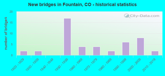
- New bridges - historical statistics
- 21920-1929
- 21930-1939
- 171950-1959
- 41960-1969
- 41970-1979
- 21980-1989
- 61990-1999
- 82000-2009
- 22010-2019
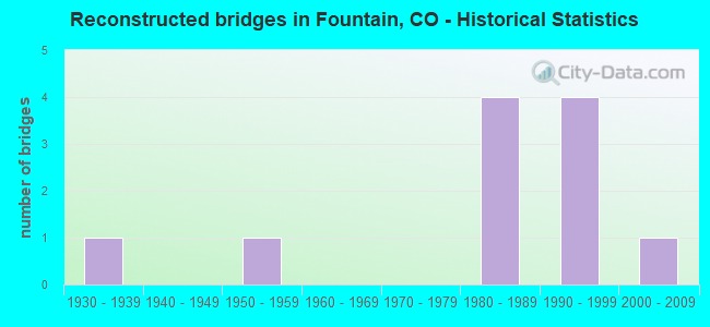
- Reconstructed bridges - Historical Statistics
- 11930-1939
- 01940-1949
- 11950-1959
- 01960-1969
- 01970-1979
- 41980-1989
- 41990-1999
- 12000-2009

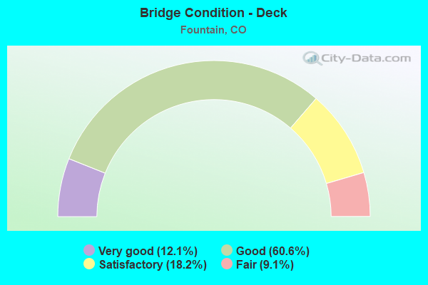
- Bridge Condition - Deck
- 12.1%Very good
- 60.6%Good
- 18.2%Satisfactory
- 9.1%Fair
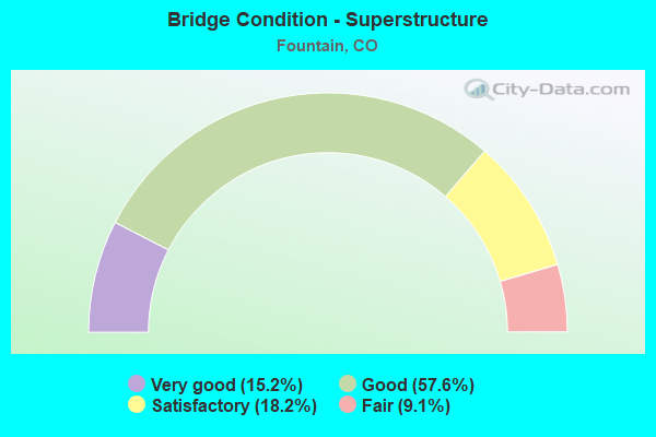
- Bridge Condition - Superstructure
- 15.2%Very good
- 57.6%Good
- 18.2%Satisfactory
- 9.1%Fair
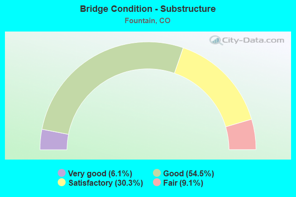
- Bridge Condition - Substructure
- 6.1%Very good
- 54.5%Good
- 30.3%Satisfactory
- 9.1%Fair
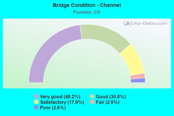
- Bridge Condition - Channel
- 46.2%Very good
- 30.8%Good
- 17.9%Satisfactory
- 2.6%Fair
- 2.6%Poor
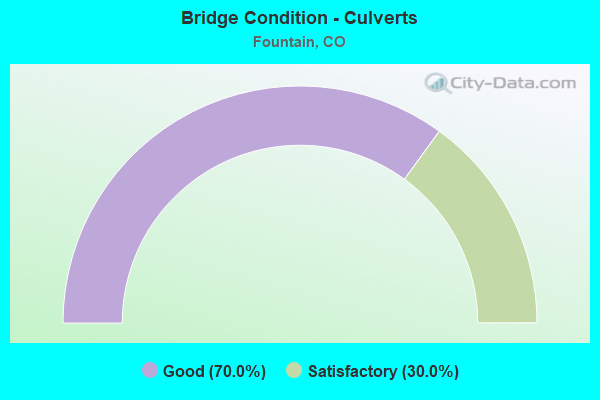
- Bridge Condition - Culverts
- 70.0%Good
- 30.0%Satisfactory
Find on map >> Show street view
Structure Number: J-18-Q, Location: AT JCT I25 ML (Lat: 38.672689, Lng: -104.709181), Route carried "on" structure: US 85A, Year Built: 2002, Status: Open, Structure Length: 5.94m (19.49ft), Average Daily Traffic: 10,000 (year 2020), Truck Traffic: 5%, Average Future Daily Traffic: 13,100 (year 2040), Design Load: HS 25 or greater, Features Intersected: I25 ML, Facility Carried by Structure: US 85 ML
Minimum Vertical Clearance: 30+ m (98+ ft), Kilometerpoint: 0.513, Lanes on structure: 4, Lanes under structure: 4, Base Highway Network: Yes, Owner: State Highway Agency, Approaching Roadway Width: 25.0m (82.0ft), Material/Design: Prestressed concrete continuous, Design/Construction: Box Beam or Girders - Multiple, Number Of Spans In Main Unit: 2, Length of Maximum Span: 29.0m (95.1ft), Curb or Sidewalk Widths: Left: 3.0m (9.8ft), Right: 0.0m, Curb-To-Curb Width: 24.8m (81.4ft), Out-to-Out Width: 28.8m (94.5ft)
Condition: Deck: Good, Superstructure: Good, Substructure: Good, Operating Rating: 42.1 metric tons, Method Used To Determine Operating Rating: Load and Resistance Factor Rating (LRFR) rating reported by rating factor(RF) method using HL-93 loadings, Inventory Rating: 32.4 metric tons, Method Used To Determine Inventory Rating: Load and Resistance Factor Rating (LRFR) rating reported by rating factor(RF) method using HL-93 loadings, Structural Evaluation: Better than present minimum criteria, Deck Geometry: Superior to present desirable criteria, Underclear: High priority of corrective action, Approach Roadway Alignment: Equal to present desirable criteria, Designated Inspection Frequency: Every 24 months, Inspection Date: November 2020, Deck Structure Type: Concrete Cast-file-Place, Wearing Surface/Protective System: Wearing Surface: Epoxy Overlay, Deck Protection: Epoxy Coated Reinforcing
Find on map >> Show street view
Structure Number: J-18-R, Location: 0.2 mi E of Jct US 85 (Lat: 38.722589, Lng: -104.714886), Route carried "on" structure: State highway 16A, Year Built: 1988, Status: Open, Structure Length: 0.97m (3.18ft), Average Daily Traffic: 32,000 (year 2020), Truck Traffic: 2%, Average Future Daily Traffic: 50,880 (year 2040), Features Intersected: OVERFLOW CHANNEL, Facility Carried by Structure: SH 16 ML
Minimum Vertical Clearance: 30+ m (98+ ft), Kilometerpoint: 1.968, Lanes on structure: 4, Owner: State Highway Agency, Approaching Roadway Width: 25.9m (85.0ft), Material/Design: Concrete, Design/Construction: Culvert, Number Of Spans In Main Unit: 3, Length of Maximum Span: 3.0m (9.8ft), Out-to-Out Width: 74.8m (245.4ft)
Condition: Channel: Good, Culverts: Good, Operating Rating: 89.8 metric tons, Method Used To Determine Operating Rating: Field evaluation and documented engineering judgment, Inventory Rating: 89.8 metric tons, Method Used To Determine Inventory Rating: Field evaluation and documented engineering judgment, Structural Evaluation: Better than present minimum criteria, Waterway Adequacy: Equal to present desirable criteria, Approach Roadway Alignment: Better than present minimum criteria, Designated Inspection Frequency: Every 24 months, Inspection Date: Febuary 2021
Find on map >> Show street view
Structure Number: J-18-BJ, Location: 0.8 MI E OF JCT I 25 (Lat: 38.722767, Lng: -104.718794), Route carried "under" structure: US 85A, Year Built: 1976, Structure Length: 0. m, Average Daily Traffic: 14,000 (year 2011), Truck Traffic: 3%, Features Intersected: US 85 ML,BNSF RR,UP RR, Facility Carried by Structure: SH 16 ML EBND
Minimum Vertical Clearance: 6.25m (20.51ft), Kilometerpoint: 211.682, Lanes on structure: 3, Lanes under structure: 2, Material/Design: Steel continuous, Design/Construction: Stringer/Multi-beam, Length of Maximum Span: 38.6m (126.6ft)
Find on map >> Show street view
Structure Number: J-18-BP, Location: 0.8 MI E OF JCT I 25 (Lat: 38.722953, Lng: -104.718864), Route carried "under" structure: US 85A, Year Built: 2009, Structure Length: 0. m, Average Daily Traffic: 14,000 (year 2011), Truck Traffic: 3%, Features Intersected: US 85 ML,BNSF RR,UP RR, Facility Carried by Structure: SH 16 ML WBND
Minimum Vertical Clearance: 7.31m (23.98ft), Kilometerpoint: 211.682, Lanes on structure: 3, Lanes under structure: 5, Material/Design: Steel, Design/Construction: Stringer/Multi-beam, Length of Maximum Span: 39.1m (128.3ft)
Find on map >> Show street view
Structure Number: J-18-P, Location: 6.4 MI S OF SH85-FOUNTAIN (Lat: 38.586722, Lng: -104.668875), Route carried "under" structure: Interstate 25A, Year Built: 1958, Structure Length: 0. m, Average Daily Traffic: 42,000 (year 2018), Truck Traffic: 11%, Features Intersected: I 25 ML, Facility Carried by Structure: COUNTY ROAD 415
Minimum Vertical Clearance: 5.59m (18.34ft), Kilometerpoint: 0.357, Lanes on structure: 2, Lanes under structure: 4, Material/Design: Concrete continuous, Design/Construction: Tee Beam, Length of Maximum Span: 20.0m (65.6ft)
Find on map >> Show street view
Structure Number: J-18-Q, Location: AT JCT I25 ML (Lat: 38.672689, Lng: -104.709181), Route carried "under" structure: Interstate 25A, Year Built: 2002, Structure Length: 0. m, Average Daily Traffic: 27,000 (year 2011), Truck Traffic: 13%, Features Intersected: I25 ML, Facility Carried by Structure: US 85 ML
Minimum Vertical Clearance: 5.00m (16.40ft), Kilometerpoint: 205.771, Lanes on structure: 4, Lanes under structure: 4, Material/Design: Prestressed concrete continuous, Design/Construction: Box Beam or Girders - Multiple, Length of Maximum Span: 29.0m (95.1ft)