Bridge Statistics for Frederick, Maryland (MD)
Condition, Traffic, Stress, Structural Evaluation, Project Costs
- National Bridge Inventory (NBI) Statistics
- 127Number of bridges
- 1,198ft / 365mTotal length
- $5,968,000Total costs
- 2,906,215Total average daily traffic
- 169,478Total average daily truck traffic
- National Bridge Inventory (NBI) Registered Bridges for Frederick
- No street view available for this location
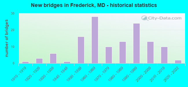
- New bridges - historical statistics
- 11910-1919
- 31920-1929
- 61930-1939
- 11940-1949
- 161950-1959
- 281960-1969
- 101970-1979
- 131980-1989
- 241990-1999
- 132000-2009
- 102010-2019
- 22020-2022

- Reconstructed bridges - Historical Statistics
- 21960-1969
- 21970-1979
- 101980-1989
- 51990-1999
- 32000-2009
- 32010-2019


- Bridge Condition - Deck
- 14.1%Very good
- 43.8%Good
- 29.7%Satisfactory
- 10.9%Fair
- 1.6%Poor

- Bridge Condition - Superstructure
- 17.4%Very good
- 37.7%Good
- 34.8%Satisfactory
- 5.8%Fair
- 4.3%Poor

- Bridge Condition - Substructure
- 13.0%Very good
- 42.0%Good
- 36.2%Satisfactory
- 7.2%Fair
- 1.4%Poor

- Bridge Condition - Channel
- 19.4%Very good
- 30.6%Good
- 37.5%Satisfactory
- 9.7%Fair
- 2.8%Poor

- Bridge Condition - Culverts
- 15.2%Very good
- 30.3%Good
- 45.5%Satisfactory
- 9.1%Fair
Find on map >> Show street view
Structure Number: 200000F-F-3103, Location: 300 FEET EAST OF MD 355 (Lat: 39.438378, Lng: -77.398947), Route carried "on" structure: City street 1329, Year Built: 1990, Status: Open, Structure Length: 1.02m (3.35ft), Average Daily Traffic: 4,172 (year 2020), Truck Traffic: 5%, Average Future Daily Traffic: 6,200 (year 2040), Design Load: H 20, Features Intersected: DETRICK BRANCH, Facility Carried by Structure: SCHIFFERSTADT BLVD
Minimum Vertical Clearance: 30+ m (98+ ft), Kilometerpoint: 0.000, Lanes on structure: 4, Owner: City or Municipal Highway Agency, Approaching Roadway Width: 14.6m (47.9ft), Skew: 22 degrees, Material/Design: Steel, Design/Construction: Arch - Deck, Number Of Spans In Main Unit: 1, Length of Maximum Span: 9.4m (30.8ft), Curb or Sidewalk Widths: Left: 1.2m (3.9ft), Right: 1.2m (3.9ft), Curb-To-Curb Width: 14.6m (47.9ft), Out-to-Out Width: 17.1m (56.1ft)
Condition: Superstructure: Satisfactory, Substructure: Good, Channel: Satisfactory, Structural Evaluation: Equal to present minimum criteria, Deck Geometry: High priority of replacement, Waterway Adequacy: Better than present minimum criteria, Approach Roadway Alignment: Equal to present desirable criteria, Designated Inspection Frequency: Every 24 months, Inspection Date: July 2020
Find on map >> Show street view
Structure Number: 200000F-F-3201, Location: 700 FEET NW OF MD 355 (Lat: 39.442500, Lng: -77.399044), Route carried "on" structure: City street 1597, Year Built: 1986, Status: Open, Structure Length: 0.61m (2.00ft), Average Daily Traffic: 1,553 (year 2020), Truck Traffic: 4%, Average Future Daily Traffic: 2,310 (year 2040), Design Load: H 20, Features Intersected: TRIBUTARY NO. 10, Facility Carried by Structure: WORMAN'S MILL COUR
Minimum Vertical Clearance: 30+ m (98+ ft), Kilometerpoint: 0.000, Lanes on structure: 2, Owner: City or Municipal Highway Agency, Approaching Roadway Width: 11.0m (36.1ft), Skew: 1 degrees, Material/Design: Steel, Design/Construction: Arch - Deck, Number Of Spans In Main Unit: 1, Length of Maximum Span: 5.8m (19.0ft), Curb or Sidewalk Widths: Left: 1.2m (3.9ft), Right: 1.2m (3.9ft), Curb-To-Curb Width: 11.0m (36.1ft), Out-to-Out Width: 13.4m (44.0ft)
Condition: Superstructure: Good, Substructure: Good, Channel: Fair, Structural Evaluation: Better than present minimum criteria, Deck Geometry: Equal to present minimum criteria, Waterway Adequacy: Equal to present minimum criteria, Approach Roadway Alignment: Equal to present desirable criteria, Designated Inspection Frequency: Every 24 months, Inspection Date: July 2020
Find on map >> Show street view
Structure Number: 200000F-F-3303, Location: 2000 FT NE OF OPOSSUMTOWN (Lat: 39.444344, Lng: -77.407489), Route carried "on" structure: City street 1456, Year Built: 1981, Status: Open, Structure Length: 0.64m (2.10ft), Average Daily Traffic: 9,105 (year 2018), Truck Traffic: 4%, Average Future Daily Traffic: 13,530 (year 2038), Features Intersected: TWO MILE RUN, Facility Carried by Structure: THOMAS JOHNSON DRI
Minimum Vertical Clearance: 30+ m (98+ ft), Kilometerpoint: 0.000, Lanes on structure: 2, Owner: City or Municipal Highway Agency, Approaching Roadway Width: 13.4m (44.0ft), Skew: 2 degrees, Material/Design: Steel, Design/Construction: Culvert, Length of Maximum Span: 2.7m (8.9ft), Curb or Sidewalk Widths: Left: 1.2m (3.9ft), Right: 1.2m (3.9ft)
Condition: Channel: Good, Culverts: Satisfactory, Structural Evaluation: Equal to present minimum criteria, Waterway Adequacy: Better than present minimum criteria, Approach Roadway Alignment: Equal to present minimum criteria, Designated Inspection Frequency: Every 24 months, Inspection Date: July 2020
Find on map >> Show street view
Structure Number: 200000F-F-3401, Location: 0.9 MI. NORTH OF MD 26 (Lat: 39.458125, Lng: -77.387933), Route carried "on" structure: City street 19, Year Built: 1996, Status: Open, Structure Length: 5.67m (18.60ft), Average Daily Traffic: 4,108 (year 2020), Truck Traffic: 4%, Average Future Daily Traffic: 6,105 (year 2040), Design Load: HS 20+Mod, Features Intersected: TUSCARORA CREEK, Facility Carried by Structure: MILL ISLAND PKWY
Minimum Vertical Clearance: 30+ m (98+ ft), Kilometerpoint: 0.000, Lanes on structure: 2, Owner: City or Municipal Highway Agency, Approaching Roadway Width: 7.9m (25.9ft), Material/Design: Steel continuous, Design/Construction: Stringer/Multi-beam, Number Of Spans In Main Unit: 2, Length of Maximum Span: 31.1m (102.0ft), Curb or Sidewalk Widths: Left: 1.9m (6.2ft), Right: 0.0m, Curb-To-Curb Width: 7.9m (25.9ft), Out-to-Out Width: 10.6m (34.8ft)
Condition: Deck: Satisfactory, Superstructure: Good, Substructure: Good, Channel: Satisfactory, Operating Rating: 74.4 metric tons, Method Used To Determine Operating Rating: Load Factor (LF), Inventory Rating: 44.9 metric tons, Method Used To Determine Inventory Rating: Load Factor (LF), Structural Evaluation: Better than present minimum criteria, Deck Geometry: High priority of corrective action, Waterway Adequacy: Superior to present desirable criteria, Approach Roadway Alignment: Equal to present desirable criteria, Designated Inspection Frequency: Every 24 months, Inspection Date: May 2020, Deck Structure Type: Concrete Cast-file-Place, Wearing Surface/Protective System: Wearing Surface: Monolithic Concrete, Deck Protection: Epoxy Coated Reinforcing
Find on map >> Show street view
Structure Number: 200000F-F-3502, Location: 0.7 MI. WEST OF US 15 (Lat: 39.456833, Lng: -77.410925), Route carried "on" structure: City street 714, Year Built: 1990, Status: Open, Structure Length: 1.19m (3.90ft), Average Daily Traffic: 7,808 (year 2020), Truck Traffic: 7%, Average Future Daily Traffic: 11,600 (year 2040), Features Intersected: OPOSSUM BRANCH, Facility Carried by Structure: HAYWARD ROAD
Minimum Vertical Clearance: 30+ m (98+ ft), Kilometerpoint: 0.000, Lanes on structure: 4, Owner: City or Municipal Highway Agency, Approaching Roadway Width: 13.4m (44.0ft), Skew: 4 degrees, Material/Design: Concrete, Design/Construction: Culvert, Length of Maximum Span: 2.4m (7.9ft), Curb or Sidewalk Widths: Left: 1.2m (3.9ft), Right: 1.2m (3.9ft), Curb-To-Curb Width: 13.4m (44.0ft), Out-to-Out Width: 22.6m (74.1ft)
Condition: Channel: Satisfactory, Culverts: Satisfactory, Operating Rating: 32.7 metric tons, Method Used To Determine Operating Rating: Field evaluation and documented engineering judgment, Inventory Rating: 32.7 metric tons, Method Used To Determine Inventory Rating: Field evaluation and documented engineering judgment, Structural Evaluation: Equal to present minimum criteria, Deck Geometry: High priority of replacement, Waterway Adequacy: Better than present minimum criteria, Approach Roadway Alignment: Equal to present desirable criteria, Designated Inspection Frequency: Every 24 months, Inspection Date: October 2020
Find on map >> Show street view
Structure Number: 200000F-F-3803, Location: 2.0 MI EAST OF MD 355 (Lat: 39.430369, Lng: -77.380158), Route carried "on" structure: City street 676, Year Built: 1968, Year Reconstructed: 2018, Status: Open, Structure Length: 1.94m (6.36ft), Average Daily Traffic: 12,302 (year 2020), Truck Traffic: 5%, Average Future Daily Traffic: 18,285 (year 2040), Features Intersected: PARK BRANCH, Facility Carried by Structure: MONOCACY BOULEVARD
Minimum Vertical Clearance: 30+ m (98+ ft), Kilometerpoint: 0.000, Lanes on structure: 4, Owner: City or Municipal Highway Agency, Approaching Roadway Width: 18.3m (60.0ft), Skew: 22 degrees, Material/Design: Steel, Design/Construction: Culvert, Length of Maximum Span: 2.4m (7.9ft), Curb or Sidewalk Widths: Left: 1.5m (4.9ft), Right: 3.1m (10.2ft)
Condition: Channel: Good, Culverts: Good, Structural Evaluation: Better than present minimum criteria, Waterway Adequacy: Equal to present minimum criteria, Approach Roadway Alignment: Equal to present desirable criteria, Designated Inspection Frequency: Every 24 months, Inspection Date: April 2020
Find on map >> Show street view
Structure Number: 200000F-F-4003, Location: 1.3 MI WEST OF US 15 (Lat: 39.440919, Lng: -77.439122), Route carried "on" structure: City street 16, Year Built: 1998, Status: Open, Structure Length: 1.13m (3.71ft), Average Daily Traffic: 4,108 (year 2020), Truck Traffic: 4%, Average Future Daily Traffic: 6,103 (year 2040), Features Intersected: EDISON BRANCH, Facility Carried by Structure: TUSCANNEY DRIVE
Minimum Vertical Clearance: 30+ m (98+ ft), Kilometerpoint: 0.000, Lanes on structure: 2, Owner: City or Municipal Highway Agency, Approaching Roadway Width: 11.0m (36.1ft), Skew: 2 degrees, Material/Design: Steel, Design/Construction: Culvert, Number Of Spans In Main Unit: 1, Length of Maximum Span: 10.4m (34.1ft), Curb or Sidewalk Widths: Left: 1.2m (3.9ft), Right: 1.2m (3.9ft)
Condition: Channel: Good, Culverts: Good, Operating Rating: 54.0 metric tons, Method Used To Determine Operating Rating: Load Factor (LF), Inventory Rating: 32.7 metric tons, Method Used To Determine Inventory Rating: Load Factor (LF), Structural Evaluation: Better than present minimum criteria, Waterway Adequacy: Better than present minimum criteria, Approach Roadway Alignment: Equal to present desirable criteria, Designated Inspection Frequency: Every 24 months, Inspection Date: October 2020
Find on map >> Show street view
Structure Number: 200000F-F-4101, Location: 0.4 MILES S OF MD 26 (Lat: 39.442756, Lng: -77.382058), Route carried "on" structure: City street 996, Year Built: 2000, Status: Open, Structure Length: 20.74m (68.04ft), Average Daily Traffic: 12,785 (year 2020), Truck Traffic: 3%, Average Future Daily Traffic: 19,000 (year 2040), Design Load: HS 25 or greater, Features Intersected: MONOCACY RIVER, Facility Carried by Structure: MONOCACY BOULEVARD
Minimum Vertical Clearance: 30+ m (98+ ft), Kilometerpoint: 0.000, Lanes on structure: 4, Owner: City or Municipal Highway Agency, Approaching Roadway Width: 13.4m (44.0ft), Material/Design: Steel continuous, Design/Construction: Stringer/Multi-beam, Number Of Spans In Main Unit: 5, Length of Maximum Span: 45.7m (149.9ft), Curb or Sidewalk Widths: Left: 1.3m (4.3ft), Right: 2.5m (8.2ft), Curb-To-Curb Width: 13.4m (44.0ft), Out-to-Out Width: 18.0m (59.1ft)
Condition: Deck: Good, Superstructure: Good, Substructure: Good, Channel: Good, Operating Rating: 60.3 metric tons, Method Used To Determine Operating Rating: Load Factor (LF), Inventory Rating: 36.3 metric tons, Method Used To Determine Inventory Rating: Load Factor (LF), Structural Evaluation: Better than present minimum criteria, Deck Geometry: High priority of replacement, Waterway Adequacy: Equal to present desirable criteria, Approach Roadway Alignment: Equal to present desirable criteria, Designated Inspection Frequency: Every 24 months, Inspection Date: May 2020, Deck Structure Type: Concrete Cast-file-Place, Wearing Surface/Protective System: Wearing Surface: Monolithic Concrete, Deck Protection: Epoxy Coated Reinforcing
Find on map >> Show street view
Structure Number: 200000F-F-4201, Location: JUST S. OF SOUTH STREET (Lat: 39.412778, Lng: -77.405556), Route carried "on" structure: State highway 475, Year Built: 1999, Status: Open, Structure Length: 0.88m (2.89ft), Average Daily Traffic: 14,234 (year 2018), Truck Traffic: 5%, Average Future Daily Traffic: 17,189 (year 2038), Design Load: HS 25 or greater, Features Intersected: CARROLL CREEK, Facility Carried by Structure: EAST STREET
Minimum Vertical Clearance: 30+ m (98+ ft), Kilometerpoint: 0.000, Lanes on structure: 4, Owner: City or Municipal Highway Agency, Approaching Roadway Width: 15.9m (52.2ft), Skew: 22 degrees, Material/Design: Concrete, Design/Construction: Slab, Number Of Spans In Main Unit: 1, Number Of Approach Spans: 4, Length of Maximum Span: 8.8m (28.9ft), Curb or Sidewalk Widths: Left: 2.2m (7.2ft), Right: 2.2m (7.2ft), Curb-To-Curb Width: 16.5m (54.1ft), Out-to-Out Width: 20.7m (67.9ft)
Condition: Deck: Good, Superstructure: Good, Substructure: Good, Channel: Good, Inventory Rating: 69.4 metric tons, Method Used To Determine Inventory Rating: Load Factor (LF), Structural Evaluation: Better than present minimum criteria, Deck Geometry: Meets minimum limits, Waterway Adequacy: Better than present minimum criteria, Approach Roadway Alignment: Better than present minimum criteria, Designated Inspection Frequency: Every 24 months, Inspection Date: Febuary 2020, Deck Structure Type: Concrete Cast-file-Place, Wearing Surface/Protective System: Wearing Surface: Bituminous
Find on map >> Show street view
Structure Number: 200000F-F-4301, Location: 200' W OF MOUNTAINDALE RD (Lat: 39.521164, Lng: -77.456119), Route carried "on" structure: ServiceCity street 366, Year Built: 2007, Status: Open, Structure Length: 1.43m (4.69ft), Average Daily Traffic: 50 (year 2020), Average Future Daily Traffic: 50 (year 2040), Features Intersected: FISHING CREEK, Facility Carried by Structure: PRIVATE LANE
Minimum Vertical Clearance: 30+ m (98+ ft), Kilometerpoint: 0.000, Lanes on structure: 1, Owner: City or Municipal Highway Agency, Approaching Roadway Width: 3.7m (12.1ft), Material/Design: Steel, Design/Construction: Truss - Thru, Number Of Spans In Main Unit: 1, Length of Maximum Span: 13.7m (44.9ft), Curb-To-Curb Width: 3.6m (11.8ft), Out-to-Out Width: 3.8m (12.5ft)
Condition: Deck: Good, Superstructure: Good, Substructure: Good, Channel: Good, Operating Rating: 32.4 metric tons, Method Used To Determine Operating Rating: Load and Resistance Factor Rating (LRFR) rating reported by rating factor(RF) method using HL-93 loadings, Inventory Rating: 25.9 metric tons, Method Used To Determine Inventory Rating: Load and Resistance Factor Rating (LRFR) rating reported by rating factor(RF) method using HL-93 loadings, Structural Evaluation: Equal to present minimum criteria, Deck Geometry: High priority of corrective action, Waterway Adequacy: Meets minimum limits, Approach Roadway Alignment: Equal to present minimum criteria, Length Of Structure Improvement: 1.37m (4.49ft), Designated Inspection Frequency: Every 24 months, Critical Feature Inspection Frequency: Every 24 months, Inspection Date: May 2020, Critical Feature Inspection Date: May 2020, Deck Structure Type: Wood or Timber, Wearing Surface/Protective System: Wearing Surface: Wood or Timber
Find on map >> Show street view
Structure Number: 200000F-F-4401, Location: 0.1 MI S. OF CHURCH ST (Lat: 39.424597, Lng: -77.384106), Route carried "on" structure: County highway , Year Built: 2012, Status: Open, Structure Length: 8.05m (26.41ft), Average Daily Traffic: 563 (year 2020), Truck Traffic: 5%, Average Future Daily Traffic: 840 (year 2040), Features Intersected: CARROLL CREEK, Facility Carried by Structure: MONOCACY BOULEVARD
Minimum Vertical Clearance: 30+ m (98+ ft), Kilometerpoint: 0.000, Lanes on structure: 2, Owner: City or Municipal Highway Agency, Approaching Roadway Width: 16.5m (54.1ft), Material/Design: Concrete, Design/Construction: Arch - Deck, Number Of Spans In Main Unit: 3, Length of Maximum Span: 25.6m (84.0ft), Curb or Sidewalk Widths: Left: 1.5m (4.9ft), Right: 2.4m (7.9ft), Curb-To-Curb Width: 16.5m (54.1ft), Out-to-Out Width: 21.7m (71.2ft)
Condition: Deck: Good, Superstructure: Good, Substructure: Good, Channel: Good, Inventory Rating: 57.1 metric tons, Method Used To Determine Inventory Rating: Load Factor (LF), Structural Evaluation: Better than present minimum criteria, Deck Geometry: Superior to present desirable criteria, Waterway Adequacy: Superior to present desirable criteria, Approach Roadway Alignment: Equal to present desirable criteria, Designated Inspection Frequency: Every 24 months, Inspection Date: Febuary 2020
Find on map >> Show street view
Structure Number: 200000F-F-45011, Location: 0.1 MI SOUTH OF GAS HOUSE (Lat: 39.432261, Lng: -77.579958), Route carried "on" structure: City street 676, Year Built: 2019, Status: Open, Structure Length: 16.19m (53.12ft), Average Daily Traffic: 5,912 (year 2018), Truck Traffic: 5%, Average Future Daily Traffic: 8,785 (year 2038), Features Intersected: MONOCACY RIVER, Facility Carried by Structure: MONOCACY BOULEVARD
Minimum Vertical Clearance: 30+ m (98+ ft), Kilometerpoint: 0.000, Lanes on structure: 2, Owner: City or Municipal Highway Agency, Approaching Roadway Width: 11.0m (36.1ft), Skew: 1 degrees, Material/Design: Steel continuous, Design/Construction: Stringer/Multi-beam, Number Of Spans In Main Unit: 3, Length of Maximum Span: 53.3m (174.9ft), Curb or Sidewalk Widths: Left: 0.0m, Right: 3.2m (10.5ft), Curb-To-Curb Width: 11.0m (36.1ft), Out-to-Out Width: 14.9m (48.9ft)
Condition: Deck: Good, Superstructure: Very good, Substructure: Good, Channel: Good, Operating Rating: 70.3 metric tons, Method Used To Determine Operating Rating: Load and Resistance Factor Rating (LRFR) rating reported by rating factor(RF) method using HL-93 loadings, Inventory Rating: 40.2 metric tons, Method Used To Determine Inventory Rating: Load and Resistance Factor Rating (LRFR) rating reported by rating factor(RF) method using HL-93 loadings, Structural Evaluation: Better than present minimum criteria, Deck Geometry: Equal to present minimum criteria, Waterway Adequacy: Equal to present desirable criteria, Approach Roadway Alignment: Equal to present desirable criteria, Length Of Structure Improvement: 16.22m (53.22ft), Designated Inspection Frequency: Every 24 months, Inspection Date: April 2020, Deck Structure Type: Concrete Cast-file-Place, Wearing Surface/Protective System: Wearing Surface: Integral Concrete, Membrane: Epoxy, Deck Protection: Epoxy Coated Reinforcing
Find on map >> Show street view
Structure Number: 200000F-F-4701, Location: WEST OF THOMAS JOHNSON DR (Lat: 39.460956, Lng: -77.406544), Route carried "on" structure: City street 484, Year Built: 2004, Status: Open, Structure Length: 2.45m (8.04ft), Average Daily Traffic: 4,614 (year 2019), Truck Traffic: 5%, Average Future Daily Traffic: 6,860 (year 2039), Design Load: HS 25 or greater, Features Intersected: TRIBUTARY OF TUSCARORA C, Facility Carried by Structure: CHRISTOPHERS CROSS
Minimum Vertical Clearance: 30+ m (98+ ft), Kilometerpoint: 0.000, Lanes on structure: 4, Owner: Town or Township Highway Agency, Maintenance Responsibility: City or Municipal Highway Agency, Approaching Roadway Width: 15.9m (52.2ft), Skew: 21 degrees, Material/Design: Concrete, Design/Construction: Arch - Deck, Number Of Spans In Main Unit: 3, Length of Maximum Span: 8.5m (27.9ft), Curb or Sidewalk Widths: Left: 1.2m (3.9ft), Right: 1.2m (3.9ft), Curb-To-Curb Width: 13.4m (44.0ft), Out-to-Out Width: 33.5m (109.9ft)
Condition: Deck: Good, Superstructure: Good, Substructure: Good, Channel: Good, Operating Rating: 62.6 metric tons, Method Used To Determine Operating Rating: Load Factor (LF), Inventory Rating: 37.6 metric tons, Method Used To Determine Inventory Rating: Load Factor (LF), Structural Evaluation: Better than present minimum criteria, Deck Geometry: High priority of replacement, Waterway Adequacy: Equal to present desirable criteria, Approach Roadway Alignment: Equal to present desirable criteria, Length Of Structure Improvement: 2.47m (8.10ft), Designated Inspection Frequency: Every 24 months, Inspection Date: November 2020
Find on map >> Show street view
Structure Number: 200000F-F-4901, Location: 0.2 MI EAST OF WATER MART (Lat: 39.464919, Lng: -77.426525), Route carried "on" structure: City street , Year Built: 2019, Status: Open, Structure Length: 2.38m (7.81ft), Average Daily Traffic: 7,000 (year 2019), Truck Traffic: 5%, Average Future Daily Traffic: 12,600 (year 2039), Features Intersected: TRIBUTARY 89, Facility Carried by Structure: CHRISTOPHERS CROSS
Minimum Vertical Clearance: 30+ m (98+ ft), Kilometerpoint: 0.000, Lanes on structure: 4, Owner: Town or Township Highway Agency, Maintenance Responsibility: City or Municipal Highway Agency, Approaching Roadway Width: 19.5m (64.0ft), Skew: 24 degrees, Material/Design: Concrete, Design/Construction: Arch - Deck, Number Of Spans In Main Unit: 3, Length of Maximum Span: 7.9m (25.9ft), Curb or Sidewalk Widths: Left: 1.5m (4.9ft), Right: 1.5m (4.9ft), Curb-To-Curb Width: 15.2m (49.9ft), Out-to-Out Width: 51.8m (169.9ft)
Condition: Deck: Good, Superstructure: Good, Substructure: Good, Channel: Very good, Operating Rating: 96.9 metric tons, Method Used To Determine Operating Rating: Load and Resistance Factor Rating (LRFR) rating reported by rating factor(RF) method using HL-93 loadings, Inventory Rating: 96.9 metric tons, Method Used To Determine Inventory Rating: Load and Resistance Factor Rating (LRFR) rating reported by rating factor(RF) method using HL-93 loadings, Structural Evaluation: Better than present minimum criteria, Deck Geometry: High priority of corrective action, Waterway Adequacy: Superior to present desirable criteria, Approach Roadway Alignment: Equal to present desirable criteria, Designated Inspection Frequency: Every 24 months, Inspection Date: December 2020
Find on map >> Show street view
Structure Number: 200000F-PK0101, Location: WEST OF OLD FREDERICK RD (Lat: 39.517169, Lng: -77.402469), Route carried "on" structure: Other road , Year Built: 2020, Status: Open, Structure Length: 0.73m (2.40ft), Average Daily Traffic: 200 (year 2020), Truck Traffic: 5%, Average Future Daily Traffic: 300 (year 2040), Features Intersected: TRIBUTARY OF FISHING CRE, Facility Carried by Structure: UTICA DISTRICT PAR
Minimum Vertical Clearance: 30+ m (98+ ft), Kilometerpoint: 0.000, Lanes on structure: 2, Owner: County Highway Agency, Approaching Roadway Width: 7.3m (24.0ft), Skew: 1 degrees, Material/Design: Concrete, Design/Construction: Arch - Deck, Number Of Spans In Main Unit: 1, Length of Maximum Span: 7.3m (24.0ft), Curb or Sidewalk Widths: Left: 0.0m, Right: 1.8m (5.9ft), Curb-To-Curb Width: 7.3m (24.0ft), Out-to-Out Width: 14.1m (46.3ft)
Condition: Deck: Very good, Superstructure: Very good, Substructure: Very good, Channel: Good, Operating Rating: 38.6 metric tons, Method Used To Determine Operating Rating: Load and Resistance Factor Rating (LRFR) rating reported by rating factor(RF) method using HL-93 loadings, Inventory Rating: 29.8 metric tons, Method Used To Determine Inventory Rating: Load and Resistance Factor Rating (LRFR) rating reported by rating factor(RF) method using HL-93 loadings, Structural Evaluation: Better than present minimum criteria, Deck Geometry: Somewhat better than minimum adequacy, Waterway Adequacy: Equal to present desirable criteria, Approach Roadway Alignment: Equal to present desirable criteria, Length Of Structure Improvement: 0.73m (2.40ft), Designated Inspection Frequency: Every 24 months, Inspection Date: September 2020
Find on map >> Show street view
Structure Number: 300000F-MT0101, Location: 0.1MI NW OF 1728 N MARKET (Lat: 39.440797, Lng: -77.402147), Route carried "on" structure: Other road , Year Built: 1920, Year Reconstructed: 1987, Status: Open, Structure Length: 0.98m (3.22ft), Average Daily Traffic: 5 (year 2014), Truck Traffic: 5%, Average Future Daily Traffic: 6 (year 2034), Features Intersected: ABANDONED RR, Facility Carried by Structure: NORMAN BALM ENTRAN
Minimum Vertical Clearance: 30+ m (98+ ft), Kilometerpoint: 107.787, Lanes on structure: 1, Owner: State Agenciy, Approaching Roadway Width: 3.4m (11.2ft), Skew: 1 degrees, Material/Design: Steel, Design/Construction: Girder and Floorbeam System, Number Of Spans In Main Unit: 1, Length of Maximum Span: 8.8m (28.9ft), Curb-To-Curb Width: 3.3m (10.8ft), Out-to-Out Width: 3.9m (12.8ft)
Condition: Deck: Satisfactory, Superstructure: Fair, Substructure: Fair, Operating Rating: 39.0 metric tons, Method Used To Determine Operating Rating: Allowable Stress (AS), Inventory Rating: 28.1 metric tons, Method Used To Determine Inventory Rating: Allowable Stress (AS), Structural Evaluation: Somewhat better than minimum adequacy, Deck Geometry: High priority of replacement, Underclear: High priority of replacement, Approach Roadway Alignment: Meets minimum limits, Length Of Structure Improvement: 0.98m (3.22ft), Designated Inspection Frequency: Every 12 months, Critical Feature Inspection Frequency: Every 12 months, Inspection Date: October 2021, Critical Feature Inspection Date: October 2021, Bridge Improvement Cost: $150,000, Roadway Improvement Cost: $50,000, Total Project Cost: $200,000, Deck Structure Type: Open Grating
Find on map >> Show street view
Structure Number: 100000100097011, Location: 0.43 MILE WEST OF MD 355 (Lat: 39.443456, Lng: -77.403233), Route carried "under" structure: State highway 26, Year Built: 1957, Structure Length: 0. m, Average Daily Traffic: 30,292 (year 2009), Features Intersected: MD 26, Facility Carried by Structure: US 15 NBR
Minimum Vertical Clearance: 4.88m (16.01ft), Kilometerpoint: 0.177, Lanes on structure: 2, Lanes under structure: 2, Material/Design: Steel, Design/Construction: Stringer/Multi-beam, Length of Maximum Span: 22.9m (75.1ft)
Find on map >> Show street view
Structure Number: 100000100097012, Location: 0.43 MILE WEST OF MD 355 (Lat: 39.443758, Lng: -77.403400), Route carried "under" structure: State highway 26, Year Built: 1968, Structure Length: 0. m, Average Daily Traffic: 30,292 (year 2009), Features Intersected: MD 26, Facility Carried by Structure: US 15 SBR
Minimum Vertical Clearance: 4.88m (16.01ft), Kilometerpoint: 0.177, Lanes on structure: 2, Lanes under structure: 2, Material/Design: Steel, Design/Construction: Stringer/Multi-beam, Length of Maximum Span: 26.8m (87.9ft)
Find on map >> Show street view
Structure Number: 10000010009801, Location: 0.53 MI S OF MD 26 (Lat: 39.435353, Lng: -77.410289), Route carried "under" structure: US 15, Year Built: 1958, Structure Length: 0. m, Average Daily Traffic: 76,550 (year 2009), Features Intersected: US 15, Facility Carried by Structure: MOTTER AVE
Minimum Vertical Clearance: 4.88m (16.01ft), Kilometerpoint: 23.491, Lanes on structure: 2, Lanes under structure: 4, Material/Design: Steel, Design/Construction: Stringer/Multi-beam, Length of Maximum Span: 26.2m (86.0ft)
Find on map >> Show street view
Structure Number: 100000100099011, Location: 1.27 MILES N OF US 40 (Lat: 39.428597, Lng: -77.419753), Route carried "under" structure: City street 9071, Year Built: 1958, Structure Length: 0. m, Average Daily Traffic: 14,161 (year 2009), Features Intersected: WEST SEVENTH ST, Facility Carried by Structure: US 15 NBR
Minimum Vertical Clearance: 4.57m (14.99ft), Kilometerpoint: 1.641, Lanes on structure: 2, Lanes under structure: 4, Material/Design: Steel, Design/Construction: Stringer/Multi-beam, Length of Maximum Span: 19.2m (63.0ft)
Find on map >> Show street view
Structure Number: 100000100099012, Location: 1.27 MILES N OF US 40 (Lat: 39.428939, Lng: -77.419569), Route carried "under" structure: City street 9071, Year Built: 1968, Structure Length: 0. m, Average Daily Traffic: 14,161 (year 2009), Features Intersected: WEST SEVENTH ST, Facility Carried by Structure: US 15 SBR
Minimum Vertical Clearance: 4.27m (14.01ft), Kilometerpoint: 1.673, Lanes on structure: 2, Lanes under structure: 4, Material/Design: Steel, Design/Construction: Stringer/Multi-beam, Length of Maximum Span: 19.2m (63.0ft)
Find on map >> Show street view
Structure Number: 100000100100011, Location: 0.77 MI N OF US 40 (Lat: 39.424264, Lng: -77.427347), Route carried "under" structure: City street 1310, Year Built: 1958, Structure Length: 0. m, Average Daily Traffic: 4,090 (year 2009), Features Intersected: ROSEMONT AVE, Facility Carried by Structure: US 15 NBR
Minimum Vertical Clearance: 5.18m (16.99ft), Kilometerpoint: 1.030, Lanes on structure: 2, Lanes under structure: 2, Material/Design: Steel, Design/Construction: Stringer/Multi-beam, Length of Maximum Span: 21.3m (69.9ft)
Find on map >> Show street view
Structure Number: 100000100100012, Location: 0.77 MI N OF US 40 (Lat: 39.424608, Lng: -77.427150), Route carried "under" structure: City street 1310, Year Built: 1968, Structure Length: 0. m, Average Daily Traffic: 4,090 (year 2009), Features Intersected: ROSEMONT AVE, Facility Carried by Structure: US 15 SBR
Minimum Vertical Clearance: 5.79m (19.00ft), Kilometerpoint: 1.030, Lanes on structure: 3, Lanes under structure: 2, Material/Design: Steel, Design/Construction: Stringer/Multi-beam, Length of Maximum Span: 21.0m (68.9ft)
Find on map >> Show street view
Structure Number: 100000100101011, Location: AT US 15 (Lat: 39.415117, Lng: -77.434906), Route carried "under" structure: US 40, Year Built: 1958, Structure Length: 0. m, Average Daily Traffic: 6,751 (year 2009), Features Intersected: US 40/W. PATRICK STREET, Facility Carried by Structure: US 15 NBR
Minimum Vertical Clearance: 4.88m (16.01ft), Kilometerpoint: 21.191, Lanes on structure: 3, Lanes under structure: 6, Material/Design: Steel, Design/Construction: Stringer/Multi-beam, Length of Maximum Span: 15.5m (50.9ft)
Find on map >> Show street view
Structure Number: 100000100101012, Location: AT US 15 (Lat: 39.415592, Lng: -77.435019), Route carried "under" structure: US 40, Year Built: 1958, Structure Length: 0. m, Average Daily Traffic: 6,751 (year 2009), Features Intersected: US 40/W. PATRICK STREET, Facility Carried by Structure: US 15 SBR
Minimum Vertical Clearance: 4.88m (16.01ft), Kilometerpoint: 21.191, Lanes on structure: 3, Lanes under structure: 6, Material/Design: Steel, Design/Construction: Stringer/Multi-beam, Length of Maximum Span: 15.5m (50.9ft)
Find on map >> Show street view
Structure Number: 10000010010201, Location: AT US 15/US 340 (Lat: 39.405847, Lng: -77.433222), Route carried "under" structure: US 15, Year Built: 1955, Structure Length: 0. m, Average Daily Traffic: 44,760 (year 2009), Features Intersected: US 15/US 40
Minimum Vertical Clearance: 4.88m (16.01ft), Kilometerpoint: 19.195, Lanes on structure: 6, Lanes under structure: 6, Material/Design: Steel, Design/Construction: Stringer/Multi-beam, Length of Maximum Span: 22.9m (75.1ft)
Find on map >> Show street view
Structure Number: 10000010010301, Location: 1.35 MILES NORTH OF MD 85 (Lat: 39.397911, Lng: -77.424694), Route carried "under" structure: Interstate 270, Year Built: 1955, Structure Length: 0. m, Average Daily Traffic: 109,670 (year 2009), Features Intersected: IS 270, Facility Carried by Structure: IS 70 EBR & RAMP L
Minimum Vertical Clearance: 4.88m (16.01ft), Kilometerpoint: 16.090, Lanes on structure: 3, Lanes under structure: 4, Material/Design: Steel, Design/Construction: Stringer/Multi-beam, Length of Maximum Span: 24.1m (79.1ft)
Find on map >> Show street view
Structure Number: 100000100106013, Location: 0.52 MI W OF MD 144FA (Lat: 39.403750, Lng: -77.393914), Route carried "under" structure: City street 1405, Year Built: 1957, Structure Length: 0. m, Average Daily Traffic: 7,841 (year 2009), Features Intersected: CSX TRANS & E SOUTH ST, Facility Carried by Structure: IS 70 EBR
Minimum Vertical Clearance: 5.49m (18.01ft), Kilometerpoint: 0.531, Lanes on structure: 2, Lanes under structure: 2, Material/Design: Steel, Design/Construction: Stringer/Multi-beam, Length of Maximum Span: 16.5m (54.1ft)
Find on map >> Show street view
Structure Number: 100000100106014, Location: 0.52 MI W OF MD 144 FA (Lat: 39.404075, Lng: -77.393483), Route carried "under" structure: City street 1405, Year Built: 1957, Structure Length: 0. m, Average Daily Traffic: 7,841 (year 2009), Features Intersected: CSX TRANS & E SOUTH ST, Facility Carried by Structure: IS 70 WBR
Minimum Vertical Clearance: 5.49m (18.01ft), Kilometerpoint: 0.515, Lanes on structure: 2, Lanes under structure: 2, Material/Design: Steel, Design/Construction: Stringer/Multi-beam, Length of Maximum Span: 16.5m (54.1ft)
Find on map >> Show street view
Structure Number: 10000010012201, Location: 0.09 MILE EAST OF IS 270 (Lat: 39.397731, Lng: -77.422186), Route carried "under" structure: Interstate 70, Year Built: 1967, Structure Length: 0. m, Average Daily Traffic: 90,670 (year 2009), Truck Traffic: 8%, Features Intersected: IS 70 EBR
Minimum Vertical Clearance: 4.88m (16.01ft), Kilometerpoint: 23.717, Lanes on structure: 2, Lanes under structure: 3, Material/Design: Steel continuous, Design/Construction: Stringer/Multi-beam, Length of Maximum Span: 31.4m (103.0ft)
Find on map >> Show street view
Structure Number: 10000010012301, Location: 0.32 M S OF BR NO 1013700 (Lat: 39.394792, Lng: -77.419950), Route carried "under" structure: County highway 324, Year Built: 2002, Structure Length: 0. m, Average Daily Traffic: 15,170 (year 2009), Features Intersected: NEW DESIGN ROAD, Facility Carried by Structure: IS 270 RAMPS J & F
Minimum Vertical Clearance: 4.57m (14.99ft), Kilometerpoint: 15.575, Lanes on structure: 3, Lanes under structure: 4, Material/Design: Steel, Design/Construction: Stringer/Multi-beam, Length of Maximum Span: 35.1m (115.2ft)
Find on map >> Show street view
Structure Number: 10000010012601, Location: 0.89 MILE EAST OF US 40AL (Lat: 39.412622, Lng: -77.473717), Route carried "under" structure: Interstate 70, Year Built: 1967, Structure Length: 0. m, Average Daily Traffic: 74,920 (year 2009), Features Intersected: IS 70, Facility Carried by Structure: MT PHILLIP ROAD
Minimum Vertical Clearance: 4.88m (16.01ft), Kilometerpoint: 18.713, Lanes on structure: 2, Lanes under structure: 4, Material/Design: Steel continuous, Design/Construction: Stringer/Multi-beam, Length of Maximum Span: 30.8m (101.0ft)
Find on map >> Show street view
Structure Number: 100000100128014, Location: 0.27 MILE EAST OF US 15 (Lat: 39.398619, Lng: -77.436944), Route carried "under" structure: State highway 180, Year Built: 1968, Structure Length: 0. m, Average Daily Traffic: 25,990 (year 2009), Features Intersected: MD 180, Facility Carried by Structure: IS 70 WBR
Minimum Vertical Clearance: 5.49m (18.01ft), Kilometerpoint: 23.749, Lanes on structure: 2, Lanes under structure: 2, Material/Design: Steel continuous, Design/Construction: Stringer/Multi-beam, Length of Maximum Span: 14.3m (46.9ft)
Find on map >> Show street view
Structure Number: 10000010013701, Location: 0.09 M N OF BR NO 1010300 (Lat: 39.398933, Lng: -77.424878), Route carried "under" structure: Interstate 270, Year Built: 1968, Structure Length: 0. m, Average Daily Traffic: 109,670 (year 2009), Features Intersected: IS 270, Facility Carried by Structure: IS 70 WBR
Minimum Vertical Clearance: 7.01m (23.00ft), Kilometerpoint: 16.235, Lanes on structure: 4, Lanes under structure: 4, Material/Design: Steel continuous, Design/Construction: Stringer/Multi-beam, Length of Maximum Span: 32.0m (105.0ft)
Find on map >> Show street view
Structure Number: 10000010013801, Location: 0.5 MILE EAST OF MD 180 (Lat: 39.399100, Lng: -77.426811), Route carried "under" structure: Ramp US 40, Year Built: 2002, Structure Length: 0. m, Average Daily Traffic: 18,542 (year 2006), Features Intersected: US 40 EBR(RAMP 5), Facility Carried by Structure: IS 70 WBR
Minimum Vertical Clearance: 5.79m (19.00ft), Kilometerpoint: 23.266, Lanes on structure: 6, Lanes under structure: 2, Material/Design: Steel, Design/Construction: Stringer/Multi-beam, Length of Maximum Span: 41.1m (134.8ft)
Find on map >> Show street view
Structure Number: 10000010014001, Location: 0.27 MILE EAST OF US 15 (Lat: 39.399069, Lng: -77.437358), Route carried "under" structure: State highway 180, Year Built: 1968, Structure Length: 0. m, Average Daily Traffic: 25,990 (year 2009), Features Intersected: MD 180, Facility Carried by Structure: IS 70 RAMPS A & E
Minimum Vertical Clearance: 5.49m (18.01ft), Kilometerpoint: 23.684, Lanes on structure: 1, Lanes under structure: 2, Material/Design: Steel continuous, Design/Construction: Stringer/Multi-beam, Length of Maximum Span: 15.2m (49.9ft)
Find on map >> Show street view
Structure Number: 10000010014301, Location: 0.09 MILE NORTH OF IS 70 (Lat: 39.400575, Lng: -77.439939), Route carried "under" structure: US 15, Year Built: 1968, Structure Length: 0. m, Average Daily Traffic: 26,810 (year 2009), Features Intersected: US 15/US 340, Facility Carried by Structure: IS 70 RAMPS A & E
Minimum Vertical Clearance: 4.88m (16.01ft), Kilometerpoint: 18.327, Lanes on structure: 1, Lanes under structure: 4, Material/Design: Steel continuous, Design/Construction: Stringer/Multi-beam, Length of Maximum Span: 28.3m (92.8ft)
Find on map >> Show street view
Structure Number: 10000010014901, Location: 0.48 MI E OF IS 70 (Lat: 39.401983, Lng: -77.437844), Route carried "under" structure: US 15, Year Built: 1968, Structure Length: 0. m, Average Daily Traffic: 44,760 (year 2009), Features Intersected: US 15, Facility Carried by Structure: MD 180
Minimum Vertical Clearance: 4.88m (16.01ft), Kilometerpoint: 18.568, Lanes on structure: 2, Lanes under structure: 7, Material/Design: Steel continuous, Design/Construction: Stringer/Multi-beam, Length of Maximum Span: 28.0m (91.9ft)
Find on map >> Show street view
Structure Number: 10000010019001, Location: 0.14 MILE WEST OF MD 351 (Lat: 39.397692, Lng: -77.437589), Route carried "under" structure: State highway 180, Year Built: 1996, Structure Length: 0. m, Average Daily Traffic: 25,990 (year 2009), Features Intersected: MD 180, Facility Carried by Structure: IS 70 RAMP 'B'
Minimum Vertical Clearance: 4.88m (16.01ft), Kilometerpoint: 23.829, Lanes on structure: 2, Lanes under structure: 2, Material/Design: Steel, Design/Construction: Stringer/Multi-beam, Length of Maximum Span: 30.5m (100.1ft)
Find on map >> Show street view
Structure Number: 10000010019301, Location: 0.34 MILE EAST OF US 15 (Lat: 39.400642, Lng: -77.427903), Route carried "under" structure: Ramp US 40, Year Built: 2002, Structure Length: 0. m, Average Daily Traffic: 18,542 (year 2006), Truck Traffic: 8%, Features Intersected: US 40 RAMP '5', Facility Carried by Structure: IS 70 RAMP '7'
Minimum Vertical Clearance: 4.88m (16.01ft), Kilometerpoint: 22.912, Lanes on structure: 1, Lanes under structure: 2, Material/Design: Steel, Design/Construction: Stringer/Multi-beam, Length of Maximum Span: 36.3m (119.1ft)
Find on map >> Show street view
Structure Number: 10000010019501, Location: AT IS 70 (Lat: 39.401175, Lng: -77.403606), Route carried "under" structure: Interstate 70, Year Built: 2009, Structure Length: 0. m, Average Daily Traffic: 82,042 (year 2012), Features Intersected: IS 70, Facility Carried by Structure: MD 85
Minimum Vertical Clearance: 5.18m (16.99ft), Kilometerpoint: 25.430, Lanes on structure: 6, Lanes under structure: 6, Material/Design: Steel continuous, Design/Construction: Girder and Floorbeam System, Length of Maximum Span: 25.3m (83.0ft)