Bridge Statistics for Fulton, Missouri (MO)
Condition, Traffic, Stress, Structural Evaluation, Project Costs
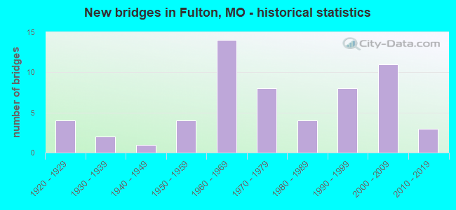
- New bridges - historical statistics
- 41920-1929
- 21930-1939
- 11940-1949
- 41950-1959
- 141960-1969
- 81970-1979
- 41980-1989
- 81990-1999
- 112000-2009
- 32010-2019
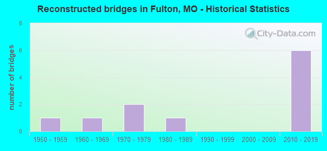
- Reconstructed bridges - Historical Statistics
- 11950-1959
- 11960-1969
- 21970-1979
- 11980-1989
- 01990-1999
- 02000-2009
- 62010-2019
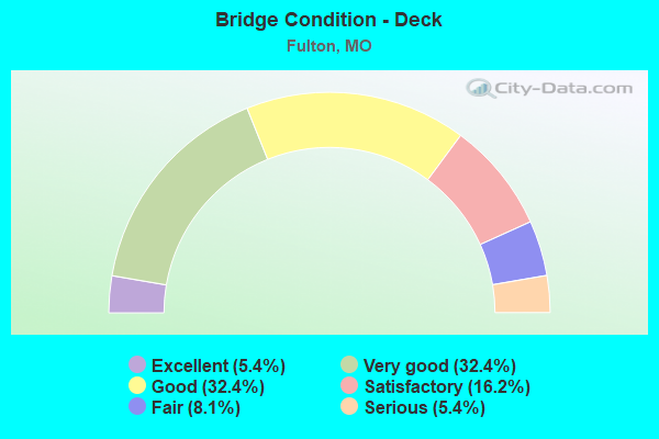
- Bridge Condition - Deck
- 5.4%Excellent
- 32.4%Very good
- 32.4%Good
- 16.2%Satisfactory
- 8.1%Fair
- 5.4%Serious
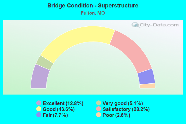
- Bridge Condition - Superstructure
- 12.8%Excellent
- 5.1%Very good
- 43.6%Good
- 28.2%Satisfactory
- 7.7%Fair
- 2.6%Poor
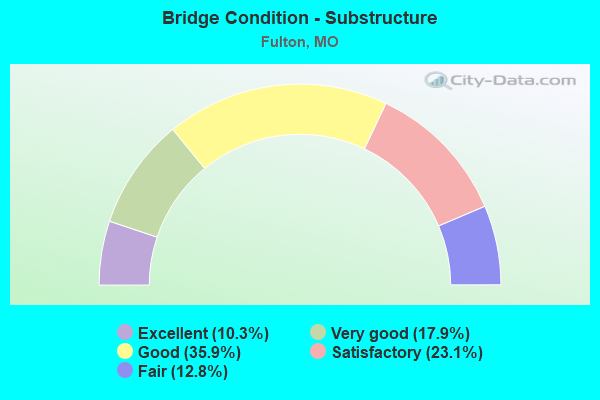
- Bridge Condition - Substructure
- 10.3%Excellent
- 17.9%Very good
- 35.9%Good
- 23.1%Satisfactory
- 12.8%Fair
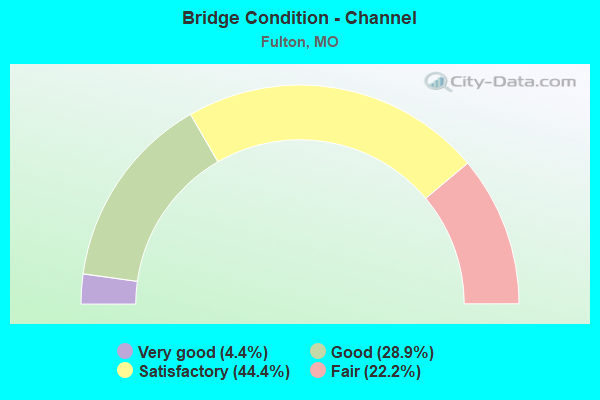
- Bridge Condition - Channel
- 4.4%Very good
- 28.9%Good
- 44.4%Satisfactory
- 22.2%Fair
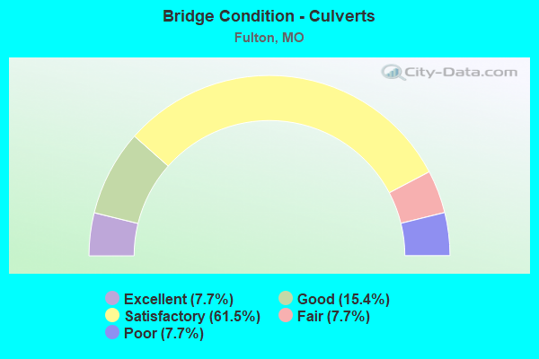
- Bridge Condition - Culverts
- 7.7%Excellent
- 15.4%Good
- 61.5%Satisfactory
- 7.7%Fair
- 7.7%Poor
Find on map >> Show street view
Structure Number: 4191, Location: S 32 T 48 N R 9 W (Lat: 38.887528, Lng: -91.946678), Route carried "on" structure: US 54, Year Built: 1992, Status: Open, Structure Length: 5.39m (17.68ft), Average Daily Traffic: 6,100 (year 2021), Truck Traffic: 24%, Average Future Daily Traffic: 11,285 (year 2041), Design Load: HS 20+Mod, Features Intersected: KCS RR
Minimum Vertical Clearance: 30+ m (98+ ft), Kilometerpoint: 124.734, Lanes on structure: 2, Base Highway Network: Yes, Owner: State Highway Agency, Approaching Roadway Width: 12.2m (40.0ft), Skew: 13 degrees, Material/Design: Prestressed concrete continuous, Design/Construction: Stringer/Multi-beam, Number Of Spans In Main Unit: 3, Length of Maximum Span: 20.9m (68.6ft), Curb or Sidewalk Widths: Left: 0.2m (0.7ft), Right: 0.2m (0.7ft), Curb-To-Curb Width: 11.8m (38.7ft), Out-to-Out Width: 12.6m (41.3ft)
Condition: Deck: Good, Superstructure: Satisfactory, Substructure: Good, Operating Rating: 73.8 metric tons, Method Used To Determine Operating Rating: Load Factor (LF), Inventory Rating: 44.1 metric tons, Method Used To Determine Inventory Rating: Load Factor (LF), Structural Evaluation: Equal to present minimum criteria, Deck Geometry: Equal to present minimum criteria, Underclear: Equal to present desirable criteria, Approach Roadway Alignment: Equal to present desirable criteria, Designated Inspection Frequency: Every 24 months, Inspection Date: October 2020, Deck Structure Type: Concrete Cast-file-Place, Wearing Surface/Protective System: Wearing Surface: Monolithic Concrete, Deck Protection: Epoxy Coated Reinforcing
Find on map >> Show street view
Structure Number: 4192, Location: S 7 T 47 N R 9 W (Lat: 38.858681, Lng: -91.970597), Route carried "on" structure: US 54, Year Built: 1992, Status: Open, Structure Length: 4.63m (15.19ft), Average Daily Traffic: 6,998 (year 2021), Truck Traffic: 19%, Average Future Daily Traffic: 12,946 (year 2041), Design Load: HS 20+Mod, Features Intersected: STINSON CR
Minimum Vertical Clearance: 30+ m (98+ ft), Kilometerpoint: 128.846, Lanes on structure: 2, Base Highway Network: Yes, Owner: State Highway Agency, Approaching Roadway Width: 12.2m (40.0ft), Skew: 12 degrees, Material/Design: Prestressed concrete continuous, Design/Construction: Stringer/Multi-beam, Number Of Spans In Main Unit: 3, Length of Maximum Span: 18.0m (59.1ft), Curb or Sidewalk Widths: Left: 0.2m (0.7ft), Right: 0.2m (0.7ft), Curb-To-Curb Width: 11.8m (38.7ft), Out-to-Out Width: 12.6m (41.3ft)
Condition: Deck: Good, Superstructure: Good, Substructure: Very good, Channel: Satisfactory, Operating Rating: 71.1 metric tons, Method Used To Determine Operating Rating: Load Factor (LF), Inventory Rating: 38.7 metric tons, Method Used To Determine Inventory Rating: Load Factor (LF), Structural Evaluation: Better than present minimum criteria, Deck Geometry: Equal to present minimum criteria, Waterway Adequacy: Equal to present desirable criteria, Approach Roadway Alignment: Equal to present desirable criteria, Designated Inspection Frequency: Every 24 months, Inspection Date: October 2020, Deck Structure Type: Concrete Cast-file-Place, Wearing Surface/Protective System: Wearing Surface: Monolithic Concrete, Deck Protection: Epoxy Coated Reinforcing
Find on map >> Show street view
Structure Number: 4936, Location: S 8 T 47 N R 9 W (Lat: 38.859819, Lng: -91.944044), Route carried "on" structure: Business State highway 54, Year Built: 1926, Year Reconstructed: 1962, Status: Open, Structure Length: 0.82m (2.69ft), Average Daily Traffic: 10,863 (year 2021), Truck Traffic: 5%, Average Future Daily Traffic: 17,924 (year 2041), Design Load: H 20, Features Intersected: SMITH BR
Minimum Vertical Clearance: 30+ m (98+ ft), Kilometerpoint: 5.829, Lanes on structure: 3, Base Highway Network: Yes, Owner: State Highway Agency, Approaching Roadway Width: 12.2m (40.0ft), Material/Design: Concrete, Design/Construction: Slab, Number Of Spans In Main Unit: 1, Length of Maximum Span: 8.1m (26.6ft), Curb-To-Curb Width: 12.7m (41.7ft), Out-to-Out Width: 12.8m (42.0ft)
Condition: Deck: Fair, Superstructure: Fair, Substructure: Good, Channel: Good, Operating Rating: 42.3 metric tons, Method Used To Determine Operating Rating: Load Factor (LF), Inventory Rating: 25.2 metric tons, Method Used To Determine Inventory Rating: Load Factor (LF), Structural Evaluation: Somewhat better than minimum adequacy, Deck Geometry: Meets minimum limits, Waterway Adequacy: Equal to present desirable criteria, Approach Roadway Alignment: Equal to present desirable criteria, Designated Inspection Frequency: Every 24 months, Inspection Date: October 2020, Deck Structure Type: Concrete Cast-file-Place, Wearing Surface/Protective System: Wearing Surface: Bituminous
Find on map >> Show street view
Structure Number: 5076, Location: S 19 T 47 N R 9 W (Lat: 38.828100, Lng: -91.965264), Route carried "on" structure: Business State highway 54, Year Built: 1928, Status: Open, Structure Length: 0.64m (2.10ft), Average Daily Traffic: 6,634 (year 2021), Truck Traffic: 9%, Average Future Daily Traffic: 10,946 (year 2041), Design Load: H 15, Features Intersected: CRAGHEAD BR
Minimum Vertical Clearance: 30+ m (98+ ft), Kilometerpoint: 1.569, Lanes on structure: 4, Base Highway Network: Yes, Owner: State Highway Agency, Approaching Roadway Width: 39.0m (128.0ft), Material/Design: Concrete continuous, Design/Construction: Culvert, Number Of Spans In Main Unit: 2, Length of Maximum Span: 3.0m (9.8ft)
Condition: Channel: Satisfactory, Culverts: Fair, Inventory Rating: 87.3 metric tons, Method Used To Determine Inventory Rating: Load Factor (LF), Structural Evaluation: Somewhat better than minimum adequacy, Waterway Adequacy: Equal to present desirable criteria, Approach Roadway Alignment: Equal to present desirable criteria, Designated Inspection Frequency: Every 24 months, Inspection Date: October 2020
Find on map >> Show street view
Structure Number: 5077, Location: S 30 T 47 N R 9 W (Lat: 38.817064, Lng: -91.980175), Route carried "on" structure: US 54, Year Built: 1968, Year Reconstructed: 1978, Status: Open, Structure Length: 0.85m (2.79ft), Average Daily Traffic: 15,325 (year 2021), Truck Traffic: 18%, Average Future Daily Traffic: 28,351 (year 2041), Design Load: HS 20, Features Intersected: YOUNGS CR
Minimum Vertical Clearance: 30+ m (98+ ft), Kilometerpoint: 303.779, Lanes on structure: 6, Base Highway Network: Yes, Owner: State Highway Agency, Approaching Roadway Width: 39.0m (128.0ft), Skew: 24 degrees, Material/Design: Concrete continuous, Design/Construction: Culvert, Number Of Spans In Main Unit: 2, Length of Maximum Span: 3.0m (9.8ft)
Condition: Channel: Satisfactory, Culverts: Satisfactory, Operating Rating: 36.0 metric tons, Method Used To Determine Operating Rating: Load Factor (LF), Inventory Rating: 21.6 metric tons, Method Used To Determine Inventory Rating: Load Factor (LF), Structural Evaluation: Somewhat better than minimum adequacy, Waterway Adequacy: Equal to present desirable criteria, Approach Roadway Alignment: Equal to present desirable criteria, Designated Inspection Frequency: Every 24 months, Inspection Date: October 2020
Find on map >> Show street view
Structure Number: 6326, Location: S 10 T 47 N R 10 W (Lat: 38.869450, Lng: -92.033236), Route carried "on" structure: State highway F, Year Built: 1953, Status: Open, Structure Length: 0.76m (2.49ft), Average Daily Traffic: 3,322 (year 2021), Truck Traffic: 4%, Average Future Daily Traffic: 5,481 (year 2041), Design Load: H 15, Features Intersected: MIDDLE RVR
Minimum Vertical Clearance: 30+ m (98+ ft), Kilometerpoint: 8.686, Lanes on structure: 2, Base Highway Network: Yes, Owner: State Highway Agency, Approaching Roadway Width: 7.3m (24.0ft), Material/Design: Concrete continuous, Design/Construction: Culvert, Number Of Spans In Main Unit: 2, Length of Maximum Span: 3.7m (12.1ft), Curb-To-Curb Width: 9.3m (30.5ft), Out-to-Out Width: 9.9m (32.5ft)
Condition: Channel: Fair, Culverts: Satisfactory, Operating Rating: 56.7 metric tons, Method Used To Determine Operating Rating: Load Factor (LF), Inventory Rating: 34.2 metric tons, Method Used To Determine Inventory Rating: Load Factor (LF), Structural Evaluation: Equal to present minimum criteria, Deck Geometry: Meets minimum limits, Waterway Adequacy: Equal to present desirable criteria, Approach Roadway Alignment: Equal to present minimum criteria, Designated Inspection Frequency: Every 24 months, Inspection Date: October 2020
Find on map >> Show street view
Structure Number: 635, Location: S 33 T 47 N R 9 W (Lat: 38.811539, Lng: -91.945581), Route carried "on" structure: State highway C, Year Built: 1953, Status: Open, Structure Length: 0.74m (2.43ft), Average Daily Traffic: 3,804 (year 2021), Truck Traffic: 5%, Average Future Daily Traffic: 5,896 (year 2041), Design Load: H 15, Features Intersected: BIG HOLLOW
Minimum Vertical Clearance: 30+ m (98+ ft), Kilometerpoint: 3.922, Lanes on structure: 2, Owner: State Highway Agency, Approaching Roadway Width: 7.3m (24.0ft), Material/Design: Concrete continuous, Design/Construction: Culvert, Number Of Spans In Main Unit: 2, Length of Maximum Span: 3.7m (12.1ft), Curb-To-Curb Width: 9.9m (32.5ft), Out-to-Out Width: 10.5m (34.4ft)
Condition: Channel: Good, Culverts: Satisfactory, Operating Rating: 68.4 metric tons, Method Used To Determine Operating Rating: Load Factor (LF), Inventory Rating: 41.4 metric tons, Method Used To Determine Inventory Rating: Load Factor (LF), Structural Evaluation: Equal to present minimum criteria, Deck Geometry: Meets minimum limits, Waterway Adequacy: Equal to present minimum criteria, Approach Roadway Alignment: Meets minimum limits, Designated Inspection Frequency: Every 24 months, Inspection Date: October 2020
Find on map >> Show street view
Structure Number: 6351, Location: S 9 T 46 N R 9 W (Lat: 38.780136, Lng: -91.938297), Route carried "on" structure: State highway C, Year Built: 1953, Status: Open, Structure Length: 0.85m (2.79ft), Average Daily Traffic: 3,804 (year 2021), Truck Traffic: 5%, Average Future Daily Traffic: 5,896 (year 2041), Design Load: H 15, Features Intersected: YOUNGS CR
Minimum Vertical Clearance: 30+ m (98+ ft), Kilometerpoint: 7.619, Lanes on structure: 2, Owner: State Highway Agency, Approaching Roadway Width: 7.3m (24.0ft), Skew: 2 degrees, Material/Design: Concrete continuous, Design/Construction: Culvert, Number Of Spans In Main Unit: 2, Length of Maximum Span: 3.7m (12.1ft), Curb-To-Curb Width: 9.3m (30.5ft), Out-to-Out Width: 9.9m (32.5ft)
Condition: Channel: Satisfactory, Culverts: Satisfactory, Operating Rating: 63.0 metric tons, Method Used To Determine Operating Rating: Load Factor (LF), Inventory Rating: 37.8 metric tons, Method Used To Determine Inventory Rating: Load Factor (LF), Structural Evaluation: Equal to present minimum criteria, Deck Geometry: Meets minimum limits, Waterway Adequacy: Equal to present desirable criteria, Approach Roadway Alignment: Equal to present desirable criteria, Designated Inspection Frequency: Every 24 months, Inspection Date: October 2020
Find on map >> Show street view
Structure Number: 6985, Location: S 13 T 47 N R 9 W (Lat: 38.845989, Lng: -91.878778), Route carried "on" structure: State highway UU, Year Built: 1957, Year Reconstructed: 2017, Status: Open, Structure Length: 6.37m (20.90ft), Average Daily Traffic: 901 (year 2021), Truck Traffic: 4%, Average Future Daily Traffic: 1,397 (year 2041), Design Load: H 10, Features Intersected: CROWS FK CR
Minimum Vertical Clearance: 30+ m (98+ ft), Kilometerpoint: 4.509, Lanes on structure: 2, Owner: State Highway Agency, Approaching Roadway Width: 6.1m (20.0ft), Material/Design: Steel continuous, Design/Construction: Stringer/Multi-beam, Number Of Spans In Main Unit: 3, Length of Maximum Span: 25.9m (85.0ft), Curb-To-Curb Width: 6.7m (22.0ft), Out-to-Out Width: 7.5m (24.6ft)
Condition: Deck: Very good, Superstructure: Satisfactory, Substructure: Satisfactory, Channel: Satisfactory, Operating Rating: 31.5 metric tons, Method Used To Determine Operating Rating: Load Factor (LF), Inventory Rating: 18.9 metric tons, Method Used To Determine Inventory Rating: Load Factor (LF), Structural Evaluation: Somewhat better than minimum adequacy, Deck Geometry: Meets minimum limits, Waterway Adequacy: Equal to present minimum criteria, Approach Roadway Alignment: High priority of corrective action, Designated Inspection Frequency: Every 24 months, Inspection Date: October 2020, Deck Structure Type: Concrete Cast-file-Place, Wearing Surface/Protective System: Deck Protection: Epoxy Coated Reinforcing
Find on map >> Show street view
Structure Number: 8337, Location: S 26 T 47 N R 10 W (Lat: 38.817619, Lng: -92.020292), Route carried "on" structure: State highway H, Year Built: 1964, Status: Posted for load, Structure Length: 4.02m (13.19ft), Average Daily Traffic: 1,306 (year 2021), Truck Traffic: 7%, Average Future Daily Traffic: 2,024 (year 2041), Design Load: H 15, Features Intersected: MIDDLE RVR
Minimum Vertical Clearance: 30+ m (98+ ft), Kilometerpoint: 6.785, Lanes on structure: 2, Owner: State Highway Agency, Approaching Roadway Width: 6.1m (20.0ft), Skew: 4 degrees, Material/Design: Steel continuous, Design/Construction: Stringer/Multi-beam, Number Of Spans In Main Unit: 3, Length of Maximum Span: 15.5m (50.9ft), Curb-To-Curb Width: 7.3m (24.0ft), Out-to-Out Width: 8.4m (27.6ft)
Condition: Deck: Serious, Superstructure: Satisfactory, Substructure: Good, Channel: Satisfactory, Operating Rating: 25.2 metric tons, Method Used To Determine Operating Rating: Allowable Stress (AS), Inventory Rating: 14.4 metric tons, Method Used To Determine Inventory Rating: Allowable Stress (AS), Structural Evaluation: Meets minimum limits, Deck Geometry: Meets minimum limits, Waterway Adequacy: Equal to present minimum criteria, Approach Roadway Alignment: Equal to present desirable criteria, Bridge Posting: Required (Relationship of Operating Rating to Maximum Legal Load: 10.0 - 19.9% below), Length Of Structure Improvement: 0.50m (1.64ft), Designated Inspection Frequency: Every 24 months, Inspection Date: October 2020, Bridge Improvement Cost: $571,000, Roadway Improvement Cost: $57,000, Total Project Cost: $856,000 ( Estimate for 2022), Deck Structure Type: Concrete Cast-file-Place, Wearing Surface/Protective System: Wearing Surface: Bituminous
Find on map >> Show street view
Structure Number: 11975, Location: S 6 T 47 N R 9 W (Lat: 38.875481, Lng: -91.964272), Route carried "under" structure: US 54, Year Built: 2001, Structure Length: 0. m, Average Daily Traffic: 7,018 (year 2021), Truck Traffic: 15%, Features Intersected: US 54, Facility Carried by Structure: RT HH S
Minimum Vertical Clearance: 5.46m (17.91ft), Kilometerpoint: 310.628, Lanes on structure: 3, Lanes under structure: 2, Material/Design: Steel continuous, Design/Construction: Stringer/Multi-beam, Length of Maximum Span: 40.3m (132.2ft)
Find on map >> Show street view
Structure Number: 11975, Location: S 6 T 47 N R 9 W (Lat: 38.875481, Lng: -91.964272), Route carried "under" structure: US 54, Year Built: 2001, Structure Length: 0. m, Average Daily Traffic: 6,100 (year 2021), Truck Traffic: 24%, Features Intersected: US 54, Facility Carried by Structure: RT HH S
Minimum Vertical Clearance: 5.41m (17.75ft), Kilometerpoint: 126.791, Lanes on structure: 3, Lanes under structure: 2, Material/Design: Steel continuous, Design/Construction: Stringer/Multi-beam, Length of Maximum Span: 40.3m (132.2ft)
Find on map >> Show street view
Structure Number: 1791, Location: S 33 T 48 N R 9 W (Lat: 38.889714, Lng: -91.943475), Route carried "under" structure: Business State highway 54, Year Built: 1968, Structure Length: 0. m, Average Daily Traffic: 2,328 (year 2021), Truck Traffic: 11%, Features Intersected: BU 54
Minimum Vertical Clearance: 4.62m (15.16ft), Kilometerpoint: 0.227, Lanes on structure: 2, Lanes under structure: 2, Material/Design: Steel continuous, Design/Construction: Stringer/Multi-beam, Length of Maximum Span: 20.7m (67.9ft)
Find on map >> Show street view
Structure Number: 1984, Location: S 18 T 47 N R 9 W (Lat: 38.847186, Lng: -91.970672), Route carried "under" structure: US 54, Year Built: 1968, Structure Length: 0. m, Average Daily Traffic: 6,998 (year 2021), Truck Traffic: 19%, Features Intersected: US 54, Facility Carried by Structure: RT F E
Minimum Vertical Clearance: 4.60m (15.09ft), Kilometerpoint: 130.141, Lanes on structure: 2, Lanes under structure: 2, Material/Design: Steel continuous, Design/Construction: Stringer/Multi-beam, Length of Maximum Span: 27.7m (90.9ft)
Find on map >> Show street view
Structure Number: 1984, Location: S 18 T 47 N R 9 W (Lat: 38.847186, Lng: -91.970672), Route carried "under" structure: US 54, Year Built: 1968, Structure Length: 0. m, Average Daily Traffic: 8,192 (year 2021), Truck Traffic: 17%, Features Intersected: US 54, Facility Carried by Structure: RT F E
Minimum Vertical Clearance: 4.60m (15.09ft), Kilometerpoint: 307.292, Lanes on structure: 2, Lanes under structure: 2, Material/Design: Steel continuous, Design/Construction: Stringer/Multi-beam, Length of Maximum Span: 27.7m (90.9ft)
Find on map >> Show street view
Structure Number: 2942, Location: S 30 T 47 N R 9 W (Lat: 38.820456, Lng: -91.978350), Route carried "under" structure: US 54, Year Built: 1978, Structure Length: 0. m, Average Daily Traffic: 7,647 (year 2021), Truck Traffic: 18%, Features Intersected: US 54, Facility Carried by Structure: RT H E
Minimum Vertical Clearance: 5.08m (16.67ft), Kilometerpoint: 304.196, Lanes on structure: 2, Lanes under structure: 2, Material/Design: Steel continuous, Design/Construction: Stringer/Multi-beam, Length of Maximum Span: 34.7m (113.8ft)
Find on map >> Show street view
Structure Number: 2942, Location: S 30 T 47 N R 9 W (Lat: 38.820456, Lng: -91.978350), Route carried "under" structure: US 54, Year Built: 1978, Structure Length: 0. m, Average Daily Traffic: 6,965 (year 2021), Truck Traffic: 23%, Features Intersected: US 54, Facility Carried by Structure: RT H E
Minimum Vertical Clearance: 5.46m (17.91ft), Kilometerpoint: 133.243, Lanes on structure: 2, Lanes under structure: 2, Material/Design: Steel continuous, Design/Construction: Stringer/Multi-beam, Length of Maximum Span: 34.7m (113.8ft)