Bridge Statistics for Gainesville, Virginia (VA)
Condition, Traffic, Stress, Structural Evaluation, Project Costs
- National Bridge Inventory (NBI) Statistics
- 65Number of bridges
- 535ft / 163mTotal length
- $3,206,000Total costs
- 1,160,594Total average daily traffic
- 48,180Total average daily truck traffic
- National Bridge Inventory (NBI) Registered Bridges for Gainesville
- No street view available for this location
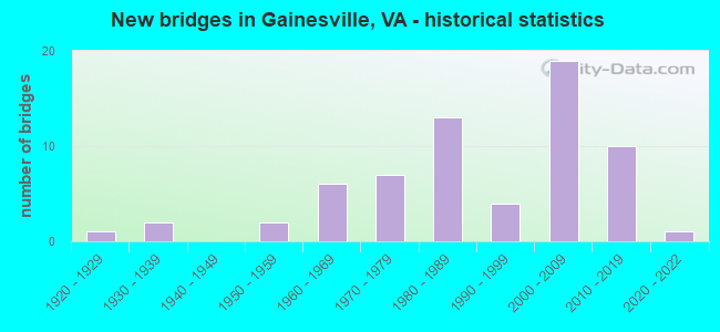
- New bridges - historical statistics
- 11920-1929
- 21930-1939
- 21950-1959
- 61960-1969
- 71970-1979
- 131980-1989
- 41990-1999
- 192000-2009
- 102010-2019
- 12020-2022
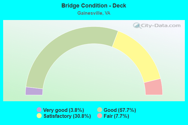
- Bridge Condition - Deck
- 3.8%Very good
- 57.7%Good
- 30.8%Satisfactory
- 7.7%Fair
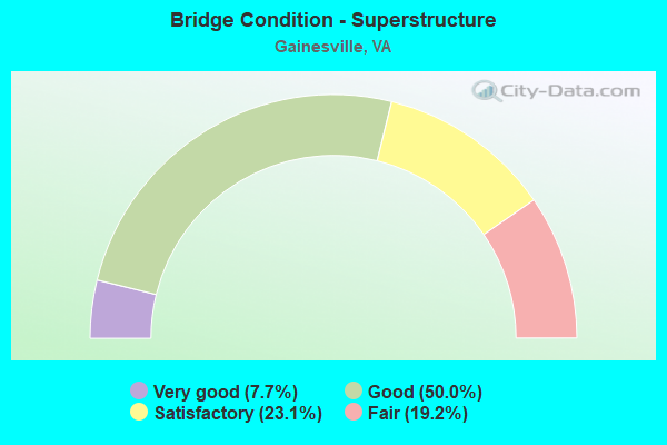
- Bridge Condition - Superstructure
- 7.7%Very good
- 50.0%Good
- 23.1%Satisfactory
- 19.2%Fair
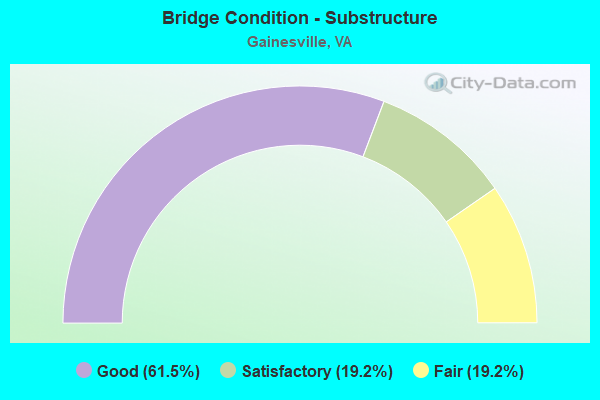
- Bridge Condition - Substructure
- 61.5%Good
- 19.2%Satisfactory
- 19.2%Fair
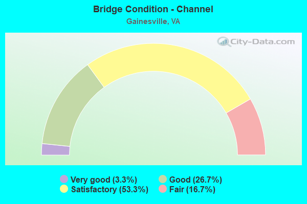
- Bridge Condition - Channel
- 3.3%Very good
- 26.7%Good
- 53.3%Satisfactory
- 16.7%Fair
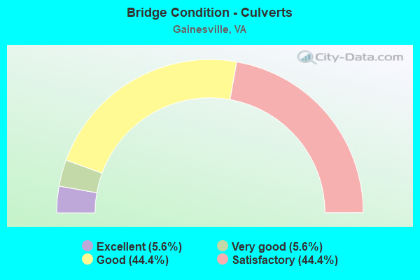
- Bridge Condition - Culverts
- 5.6%Excellent
- 5.6%Very good
- 44.4%Good
- 44.4%Satisfactory
Find on map >> Show street view
Structure Number: 7179, Location: .66 Fr PrWmCL &.12 To 628 (Lat: 38.825344, Lng: -77.720650), Route carried "on" structure: US 55, Year Built: 1936, Year Reconstructed: 2000, Status: Open, Structure Length: 1.30m (4.27ft), Average Daily Traffic: 1,768 (year 2020), Truck Traffic: 3%, Average Future Daily Traffic: 1,945 (year 2040), Design Load: HS 20, Features Intersected: Trapp Branch, Facility Carried by Structure: John Marshall Hwy
Minimum Vertical Clearance: 30+ m (98+ ft), Kilometerpoint: 94.291, Lanes on structure: 2, Owner: State Highway Agency, Approaching Roadway Width: 6.4m (21.0ft), Material/Design: Prestressed concrete, Design/Construction: Slab, Number Of Spans In Main Unit: 1, Length of Maximum Span: 12.2m (40.0ft), Curb-To-Curb Width: 9.1m (29.9ft), Out-to-Out Width: 9.8m (32.2ft)
Condition: Deck: Good, Superstructure: Good, Substructure: Good, Channel: Satisfactory, Operating Rating: 67.1 metric tons, Method Used To Determine Operating Rating: Load and Resistance Factor (LRFR), Inventory Rating: 51.7 metric tons, Method Used To Determine Inventory Rating: Load and Resistance Factor (LRFR), Structural Evaluation: Better than present minimum criteria, Deck Geometry: Somewhat better than minimum adequacy, Waterway Adequacy: Equal to present minimum criteria, Approach Roadway Alignment: Equal to present desirable criteria, Designated Inspection Frequency: Every 24 months, Inspection Date: March 2020, Deck Structure Type: Other, Wearing Surface/Protective System: Wearing Surface: Bituminous, Membrane: Epoxy, Deck Protection: Epoxy Coated Reinforcing
Find on map >> Show street view
Structure Number: 7237, Location: .77 Fr 55 & .59 PrWllm CL (Lat: 38.825672, Lng: -77.720319), Route carried "on" structure: Interstate 66, Year Built: 1979, Status: Open, Structure Length: 1.34m (4.40ft), Average Daily Traffic: 37,827 (year 2020), Truck Traffic: 8%, Average Future Daily Traffic: 52,958 (year 2040), Design Load: HS 20, Features Intersected: Trapp Branch
Minimum Vertical Clearance: 30+ m (98+ ft), Kilometerpoint: 57.924, Lanes on structure: 4, Base Highway Network: Yes, Owner: State Highway Agency, Approaching Roadway Width: 26.2m (86.0ft), Skew: 1 degrees, Material/Design: Concrete, Design/Construction: Culvert, Number Of Spans In Main Unit: 4, Length of Maximum Span: 3.4m (11.2ft)
Condition: Channel: Satisfactory, Culverts: Satisfactory, Operating Rating: 89.8 metric tons, Method Used To Determine Operating Rating: Load Factor (LF), Inventory Rating: 89.8 metric tons, Method Used To Determine Inventory Rating: Load Factor (LF), Structural Evaluation: Equal to present minimum criteria, Waterway Adequacy: Equal to present desirable criteria, Approach Roadway Alignment: Equal to present desirable criteria, Designated Inspection Frequency: Every 24 months, Inspection Date: April 2020
Find on map >> Show street view
Structure Number: 7296, Location: .20 Fr 55 & 3.30 To 601 (Lat: 38.828183, Lng: -77.722189), Route carried "on" structure: County highway 628, Year Built: 1932, Year Reconstructed: 2009, Status: Posted for load, Structure Length: 1.74m (5.71ft), Average Daily Traffic: 17 (year 2019), Average Future Daily Traffic: 19 (year 2040), Design Load: HS 20, Features Intersected: Broad Run, Facility Carried by Structure: Bust Head Road
Minimum Vertical Clearance: 30+ m (98+ ft), Kilometerpoint: 19.179, Lanes on structure: 1, Owner: State Highway Agency, Approaching Roadway Width: 4.6m (15.1ft), Material/Design: Steel, Design/Construction: Stringer/Multi-beam, Number Of Spans In Main Unit: 1, Length of Maximum Span: 17.4m (57.1ft), Curb or Sidewalk Widths: Left: 0.2m (0.7ft), Right: 0.2m (0.7ft), Curb-To-Curb Width: 4.7m (15.4ft), Out-to-Out Width: 5.0m (16.4ft)
Condition: Deck: Satisfactory, Superstructure: Fair, Substructure: Fair, Channel: Fair, Operating Rating: 29.0 metric tons, Method Used To Determine Operating Rating: Load Factor (LF), Inventory Rating: 17.2 metric tons, Method Used To Determine Inventory Rating: Load Factor (LF), Structural Evaluation: Somewhat better than minimum adequacy, Deck Geometry: Better than present minimum criteria, Waterway Adequacy: Equal to present minimum criteria, Approach Roadway Alignment: Equal to present minimum criteria, Bridge Posting: Required (Relationship of Operating Rating to Maximum Legal Load: 0.1 - 9.9% below), Length Of Structure Improvement: 1.74m (5.71ft), Designated Inspection Frequency: Every 24 months, Inspection Date: May 2020, Bridge Improvement Cost: $30,000, Roadway Improvement Cost: $10,000, Total Project Cost: $45,000, Deck Structure Type: Wood or Timber
Find on map >> Show street view
Structure Number: 14138, Location: 00.02FR55/00.03TO F287 (Lat: 38.822589, Lng: -77.691619), Route carried "on" structure: ServiceCounty highway F289, Year Built: 1980, Status: Open, Structure Length: 8.17m (26.80ft), Average Daily Traffic: 578 (year 2013), Average Future Daily Traffic: 656 (year 2040), Design Load: HS 20+Mod, Features Intersected: ROUTE I-66, Facility Carried by Structure: TURNER ROAD
Minimum Vertical Clearance: 30+ m (98+ ft), Kilometerpoint: 0.064, Lanes on structure: 2, Lanes under structure: 4, Owner: State Highway Agency, Approaching Roadway Width: 6.4m (21.0ft), Material/Design: Steel continuous, Design/Construction: Stringer/Multi-beam, Number Of Spans In Main Unit: 2, Length of Maximum Span: 40.8m (133.9ft), Curb or Sidewalk Widths: Left: 0.2m (0.7ft), Right: 0.2m (0.7ft), Curb-To-Curb Width: 8.9m (29.2ft), Out-to-Out Width: 9.9m (32.5ft)
Condition: Deck: Good, Superstructure: Good, Substructure: Good, Operating Rating: 64.4 metric tons, Method Used To Determine Operating Rating: Load and Resistance Factor (LRFR), Inventory Rating: 49.9 metric tons, Method Used To Determine Inventory Rating: Load and Resistance Factor (LRFR), Structural Evaluation: Better than present minimum criteria, Deck Geometry: Somewhat better than minimum adequacy, Underclear: Somewhat better than minimum adequacy, Approach Roadway Alignment: Equal to present desirable criteria, Length Of Structure Improvement: 0.30m (0.98ft), Designated Inspection Frequency: Every 24 months, Inspection Date: April 2020, Bridge Improvement Cost: $1,000, Roadway Improvement Cost: $1,000, Total Project Cost: $3,000 ( Estimate for 2014), Deck Structure Type: Concrete Cast-file-Place
Find on map >> Show street view
Structure Number: 14169, Location: 00.05TO683 / 00.07FR684 (Lat: 38.780564, Lng: -77.672378), Route carried "on" structure: US 15, Year Built: 1980, Status: Open, Structure Length: 4.48m (14.70ft), Average Daily Traffic: 27,383 (year 2020), Truck Traffic: 4%, Average Future Daily Traffic: 38,336 (year 2040), Design Load: HS 20, Features Intersected: BROAD RUN, Facility Carried by Structure: LEE HIGHWAY_NB
Minimum Vertical Clearance: 30+ m (98+ ft), Kilometerpoint: 343.940, Lanes on structure: 2, Base Highway Network: Yes, Owner: State Highway Agency, Approaching Roadway Width: 15.8m (51.8ft), Skew: 3 degrees, Material/Design: Steel, Design/Construction: Stringer/Multi-beam, Number Of Spans In Main Unit: 3, Length of Maximum Span: 18.6m (61.0ft), Curb or Sidewalk Widths: Left: 0.2m (0.7ft), Right: 0.2m (0.7ft), Curb-To-Curb Width: 11.7m (38.4ft), Out-to-Out Width: 12.7m (41.7ft)
Condition: Deck: Satisfactory, Superstructure: Fair, Substructure: Fair, Channel: Satisfactory, Operating Rating: 89.8 metric tons, Method Used To Determine Operating Rating: Load and Resistance Factor (LRFR), Inventory Rating: 69.3 metric tons, Method Used To Determine Inventory Rating: Load and Resistance Factor (LRFR), Structural Evaluation: Somewhat better than minimum adequacy, Deck Geometry: Better than present minimum criteria, Waterway Adequacy: Equal to present desirable criteria, Approach Roadway Alignment: Equal to present desirable criteria, Length Of Structure Improvement: 4.48m (14.70ft), Designated Inspection Frequency: Every 24 months, Inspection Date: April 2020, Bridge Improvement Cost: $57,000, Roadway Improvement Cost: $79,000, Total Project Cost: $145,000, Deck Structure Type: Concrete Cast-file-Place, Wearing Surface/Protective System: Wearing Surface: Monolithic Concrete
Find on map >> Show street view
Structure Number: 14173, Location: 00.24 55 / 01.14 625 (Lat: 38.813236, Lng: -77.646611), Route carried "on" structure: US 15, Year Built: 1991, Status: Open, Structure Length: 2.68m (8.79ft), Average Daily Traffic: 10,038 (year 2020), Truck Traffic: 5%, Average Future Daily Traffic: 14,053 (year 2040), Design Load: HS 20, Features Intersected: NORTH FORK CREEK, Facility Carried by Structure: JAMES MADISON HIWY
Minimum Vertical Clearance: 30+ m (98+ ft), Kilometerpoint: 313.707, Lanes on structure: 2, Base Highway Network: Yes, Owner: State Highway Agency, Approaching Roadway Width: 7.0m (23.0ft), Skew: 3 degrees, Material/Design: Prestressed concrete, Design/Construction: Box Beam or Girders - Multiple, Number Of Spans In Main Unit: 2, Length of Maximum Span: 13.4m (44.0ft), Curb-To-Curb Width: 15.5m (50.9ft), Out-to-Out Width: 16.5m (54.1ft)
Condition: Deck: Satisfactory, Superstructure: Satisfactory, Substructure: Good, Channel: Satisfactory, Operating Rating: 95.3 metric tons, Method Used To Determine Operating Rating: Load and Resistance Factor (LRFR), Inventory Rating: 73.6 metric tons, Method Used To Determine Inventory Rating: Load and Resistance Factor (LRFR), Structural Evaluation: Equal to present minimum criteria, Deck Geometry: Superior to present desirable criteria, Waterway Adequacy: Equal to present minimum criteria, Approach Roadway Alignment: Equal to present desirable criteria, Length Of Structure Improvement: 2.68m (8.79ft), Designated Inspection Frequency: Every 24 months, Inspection Date: July 2021, Bridge Improvement Cost: $33,000, Roadway Improvement Cost: $75,000, Total Project Cost: $125,000 ( Estimate for 2015), Deck Structure Type: Concrete Cast-file-Place, Wearing Surface/Protective System: Wearing Surface: Bituminous, Membrane: Epoxy
Find on map >> Show street view
Structure Number: 14174, Location: 00.55FR215 00.36TO15 (Lat: 38.780731, Lng: -77.672522), Route carried "on" structure: US 15, Year Built: 1953, Year Reconstructed: 2008, Status: Open, Structure Length: 3.96m (12.99ft), Average Daily Traffic: 27,383 (year 2020), Truck Traffic: 4%, Average Future Daily Traffic: 38,336 (year 2040), Design Load: HS 20, Features Intersected: BROAD RUN
Minimum Vertical Clearance: 30+ m (98+ ft), Kilometerpoint: 343.924, Lanes on structure: 2, Base Highway Network: Yes, Owner: State Highway Agency, Approaching Roadway Width: 11.0m (36.1ft), Skew: 3 degrees, Material/Design: Steel, Design/Construction: Stringer/Multi-beam, Number Of Spans In Main Unit: 3, Length of Maximum Span: 12.8m (42.0ft), Curb-To-Curb Width: 11.0m (36.1ft), Out-to-Out Width: 11.7m (38.4ft)
Condition: Deck: Good, Superstructure: Very good, Substructure: Good, Channel: Good, Operating Rating: 71.8 metric tons, Method Used To Determine Operating Rating: Load and Resistance Factor (LRFR), Inventory Rating: 55.4 metric tons, Method Used To Determine Inventory Rating: Load and Resistance Factor (LRFR), Structural Evaluation: Better than present minimum criteria, Deck Geometry: Equal to present minimum criteria, Waterway Adequacy: Equal to present minimum criteria, Approach Roadway Alignment: Better than present minimum criteria, Length Of Structure Improvement: 3.96m (12.99ft), Designated Inspection Frequency: Every 24 months, Underwater Inspection Frequency: Every 60 months, Inspection Date: April 2020, Underwater Inspection Date: October 2017, Bridge Improvement Cost: $210,000, Roadway Improvement Cost: $21,000, Total Project Cost: $241,000, Deck Structure Type: Concrete Cast-file-Place, Wearing Surface/Protective System: Wearing Surface: Bituminous
Find on map >> Show street view
Structure Number: 14177, Location: 00.39FR625/00.99TO55 (Lat: 38.806567, Lng: -77.657039), Route carried "on" structure: US 15, Year Built: 1965, Status: Open, Structure Length: 0.76m (2.49ft), Average Daily Traffic: 10,038 (year 2020), Truck Traffic: 5%, Average Future Daily Traffic: 14,053 (year 2040), Design Load: HS 20, Features Intersected: TRIBUTARY OF BROAD RUN, Facility Carried by Structure: JAMES MADISON HIWY
Minimum Vertical Clearance: 30+ m (98+ ft), Kilometerpoint: 312.532, Lanes on structure: 2, Base Highway Network: Yes, Owner: State Highway Agency, Approaching Roadway Width: 7.3m (24.0ft), Skew: 4 degrees, Material/Design: Concrete, Design/Construction: Culvert, Number Of Spans In Main Unit: 4, Length of Maximum Span: 1.8m (5.9ft)
Condition: Channel: Satisfactory, Culverts: Good, Operating Rating: 89.8 metric tons, Method Used To Determine Operating Rating: Load Factor (LF), Inventory Rating: 89.8 metric tons, Method Used To Determine Inventory Rating: Load Factor (LF), Structural Evaluation: Better than present minimum criteria, Waterway Adequacy: Equal to present minimum criteria, Approach Roadway Alignment: Equal to present desirable criteria, Length Of Structure Improvement: 0.30m (0.98ft), Designated Inspection Frequency: Every 24 months, Inspection Date: October 2021, Bridge Improvement Cost: $1,000, Roadway Improvement Cost: $1,000, Total Project Cost: $3,000 ( Estimate for 2014)
Find on map >> Show street view
Structure Number: 14189, Location: 00.45FR.647/00.65TO619 (Lat: 38.792772, Lng: -77.625086), Route carried "on" structure: US 29, Year Built: 1928, Year Reconstructed: 2013, Status: Open, Structure Length: 1.01m (3.31ft), Average Daily Traffic: 24,671 (year 2020), Truck Traffic: 4%, Average Future Daily Traffic: 34,539 (year 2040), Design Load: HS 20, Features Intersected: NORTH FORK, Facility Carried by Structure: LEE HIGHWAY SB
Minimum Vertical Clearance: 30+ m (98+ ft), Kilometerpoint: 5.052, Lanes on structure: 2, Base Highway Network: Yes, Owner: State Highway Agency, Approaching Roadway Width: 7.3m (24.0ft), Material/Design: Prestressed concrete, Design/Construction: Slab, Number Of Spans In Main Unit: 1, Length of Maximum Span: 10.1m (33.1ft), Curb or Sidewalk Widths: Left: 0.3m (1.0ft), Right: 0.3m (1.0ft), Curb-To-Curb Width: 12.8m (42.0ft), Out-to-Out Width: 14.0m (45.9ft)
Condition: Deck: Good, Superstructure: Very good, Substructure: Good, Channel: Satisfactory, Operating Rating: 61.7 metric tons, Method Used To Determine Operating Rating: Load and Resistance Factor (LRFR), Inventory Rating: 47.2 metric tons, Method Used To Determine Inventory Rating: Load and Resistance Factor (LRFR), Structural Evaluation: Better than present minimum criteria, Deck Geometry: Equal to present desirable criteria, Waterway Adequacy: Somewhat better than minimum adequacy, Approach Roadway Alignment: Better than present minimum criteria, Length Of Structure Improvement: 1.01m (3.31ft), Designated Inspection Frequency: Every 24 months, Inspection Date: July 2021, Bridge Improvement Cost: $300,000, Roadway Improvement Cost: $25,000, Total Project Cost: $330,000, Deck Structure Type: Concrete Cast-file-Place, Wearing Surface/Protective System: Wearing Surface: Bituminous
Find on map >> Show street view
Structure Number: 1419, Location: 00.45FR.647/00.66TO619 (Lat: 38.792581, Lng: -77.625100), Route carried "on" structure: US 29, Year Built: 1957, Status: Open, Structure Length: 1.22m (4.00ft), Average Daily Traffic: 24,671 (year 2020), Truck Traffic: 4%, Average Future Daily Traffic: 34,539 (year 2040), Design Load: HS 20, Features Intersected: NORTH FORK, Facility Carried by Structure: LEE HIGHWAY NB
Minimum Vertical Clearance: 30+ m (98+ ft), Kilometerpoint: 5.052, Lanes on structure: 2, Base Highway Network: Yes, Owner: State Highway Agency, Approaching Roadway Width: 12.2m (40.0ft), Skew: 2 degrees, Material/Design: Concrete, Design/Construction: Stringer/Multi-beam, Number Of Spans In Main Unit: 1, Length of Maximum Span: 12.2m (40.0ft), Curb-To-Curb Width: 12.2m (40.0ft), Out-to-Out Width: 12.8m (42.0ft)
Condition: Deck: Satisfactory, Superstructure: Satisfactory, Substructure: Satisfactory, Channel: Satisfactory, Operating Rating: 45.0 metric tons, Method Used To Determine Operating Rating: Load and Resistance Factor (LRFR), Inventory Rating: 34.7 metric tons, Method Used To Determine Inventory Rating: Load and Resistance Factor (LRFR), Structural Evaluation: Equal to present minimum criteria, Deck Geometry: Better than present minimum criteria, Waterway Adequacy: Somewhat better than minimum adequacy, Approach Roadway Alignment: Equal to present desirable criteria, Length Of Structure Improvement: 1.22m (4.00ft), Designated Inspection Frequency: Every 24 months, Inspection Date: July 2021, Bridge Improvement Cost: $33,000, Roadway Improvement Cost: $66,000, Total Project Cost: $125,000 ( Estimate for 2015), Deck Structure Type: Concrete Cast-file-Place, Wearing Surface/Protective System: Wearing Surface: Bituminous
Find on map >> Show street view
Structure Number: 14201, Location: 01.48FR716 / 00.22TO600 (Lat: 38.823036, Lng: -77.705681), Route carried "on" structure: State highway 55, Year Built: 1972, Status: Open, Structure Length: 5.88m (19.29ft), Average Daily Traffic: 6,512 (year 2020), Truck Traffic: 3%, Average Future Daily Traffic: 9,117 (year 2040), Design Load: HS 20+Mod, Features Intersected: BROAD RUN, Facility Carried by Structure: JOHN MARSHALL HWY.
Minimum Vertical Clearance: 30+ m (98+ ft), Kilometerpoint: 95.655, Lanes on structure: 2, Owner: State Highway Agency, Approaching Roadway Width: 7.6m (24.9ft), Skew: 3 degrees, Material/Design: Prestressed concrete, Design/Construction: Stringer/Multi-beam, Number Of Spans In Main Unit: 3, Length of Maximum Span: 21.6m (70.9ft), Curb or Sidewalk Widths: Left: 0.3m (1.0ft), Right: 0.3m (1.0ft), Curb-To-Curb Width: 13.1m (43.0ft), Out-to-Out Width: 14.3m (46.9ft)
Condition: Deck: Fair, Superstructure: Fair, Substructure: Fair, Channel: Good, Operating Rating: 81.7 metric tons, Method Used To Determine Operating Rating: Load and Resistance Factor (LRFR), Inventory Rating: 39.6 metric tons, Method Used To Determine Inventory Rating: Load and Resistance Factor (LRFR), Structural Evaluation: Somewhat better than minimum adequacy, Deck Geometry: Somewhat better than minimum adequacy, Waterway Adequacy: Better than present minimum criteria, Approach Roadway Alignment: Better than present minimum criteria, Length Of Structure Improvement: 0.30m (0.98ft), Designated Inspection Frequency: Every 24 months, Inspection Date: April 2020, Bridge Improvement Cost: $1,000, Roadway Improvement Cost: $1,000, Total Project Cost: $3,000, Deck Structure Type: Concrete Cast-file-Place, Wearing Surface/Protective System: Wearing Surface: Latex Concrete
Find on map >> Show street view
Structure Number: 14211, Location: 7.1 Rte 245/1.42 Rte15 (Lat: 38.821392, Lng: -77.665933), Route carried "on" structure: Interstate 66, Year Built: 1979, Status: Open, Structure Length: 0.70m (2.30ft), Average Daily Traffic: 37,827 (year 2020), Truck Traffic: 8%, Average Future Daily Traffic: 52,508 (year 2040), Design Load: HS 20, Features Intersected: NORTH FORK
Minimum Vertical Clearance: 30+ m (98+ ft), Kilometerpoint: 0.097, Lanes on structure: 4, Base Highway Network: Yes, Owner: State Highway Agency, Approaching Roadway Width: 22.6m (74.1ft), Skew: 4 degrees, Material/Design: Concrete, Design/Construction: Culvert, Number Of Spans In Main Unit: 3, Length of Maximum Span: 2.1m (6.9ft)
Condition: Channel: Good, Culverts: Satisfactory, Operating Rating: 89.8 metric tons, Method Used To Determine Operating Rating: Load Factor (LF), Inventory Rating: 74.4 metric tons, Method Used To Determine Inventory Rating: Load Factor (LF), Structural Evaluation: Equal to present minimum criteria, Waterway Adequacy: Superior to present desirable criteria, Approach Roadway Alignment: Equal to present desirable criteria, Length Of Structure Improvement: 0.30m (0.98ft), Designated Inspection Frequency: Every 24 months, Inspection Date: July 2020, Bridge Improvement Cost: $33,000, Roadway Improvement Cost: $49,000, Total Project Cost: $90,000
Find on map >> Show street view
Structure Number: 14214, Location: 06.40FR245/02.16TO15 (Lat: 38.821564, Lng: -77.679728), Route carried "on" structure: Interstate 66, Year Built: 1980, Status: Open, Structure Length: 8.23m (27.00ft), Average Daily Traffic: 18,818 (year 2020), Truck Traffic: 8%, Average Future Daily Traffic: 26,345 (year 2040), Design Load: HS 20, Features Intersected: SOUTHERN RAILWAY
Minimum Vertical Clearance: 30+ m (98+ ft), Kilometerpoint: 61.512, Lanes on structure: 2, Base Highway Network: Yes, Owner: State Highway Agency, Approaching Roadway Width: 11.6m (38.1ft), Skew: 5 degrees, Material/Design: Steel, Design/Construction: Stringer/Multi-beam, Number Of Spans In Main Unit: 3, Length of Maximum Span: 27.4m (89.9ft), Curb or Sidewalk Widths: Left: 0.2m (0.7ft), Right: 0.2m (0.7ft), Curb-To-Curb Width: 12.4m (40.7ft), Out-to-Out Width: 13.4m (44.0ft)
Condition: Deck: Fair, Superstructure: Fair, Substructure: Fair, Operating Rating: 79.4 metric tons, Method Used To Determine Operating Rating: Load and Resistance Factor (LRFR), Inventory Rating: 61.2 metric tons, Method Used To Determine Inventory Rating: Load and Resistance Factor (LRFR), Structural Evaluation: Somewhat better than minimum adequacy, Deck Geometry: Better than present minimum criteria, Underclear: Equal to present minimum criteria, Approach Roadway Alignment: Equal to present desirable criteria, Length Of Structure Improvement: 8.23m (27.00ft), Designated Inspection Frequency: Every 24 months, Inspection Date: October 2020, Bridge Improvement Cost: $64,000, Roadway Improvement Cost: $99,000, Total Project Cost: $175,000 ( Estimate for 2014), Deck Structure Type: Concrete Cast-file-Place, Wearing Surface/Protective System: Wearing Surface: Monolithic Concrete, Deck Protection: Epoxy Coated Reinforcing
Find on map >> Show street view
Structure Number: 14216, Location: 06.60FR245/01.92TO15 (Lat: 38.821508, Lng: -77.675650), Route carried "on" structure: Interstate 66, Year Built: 1980, Status: Open, Structure Length: 3.44m (11.29ft), Average Daily Traffic: 18,818 (year 2020), Truck Traffic: 8%, Average Future Daily Traffic: 26,345 (year 2040), Design Load: HS 20, Features Intersected: THOROUGHFARE ROAD
Minimum Vertical Clearance: 30+ m (98+ ft), Kilometerpoint: 61.882, Lanes on structure: 2, Lanes under structure: 2, Base Highway Network: Yes, Owner: State Highway Agency, Approaching Roadway Width: 11.3m (37.1ft), Material/Design: Prestressed concrete, Design/Construction: Stringer/Multi-beam, Number Of Spans In Main Unit: 3, Length of Maximum Span: 12.2m (40.0ft), Curb or Sidewalk Widths: Left: 0.2m (0.7ft), Right: 0.2m (0.7ft), Curb-To-Curb Width: 12.4m (40.7ft), Out-to-Out Width: 13.4m (44.0ft)
Condition: Deck: Satisfactory, Superstructure: Fair, Substructure: Fair, Operating Rating: 80.0 metric tons, Method Used To Determine Operating Rating: Load and Resistance Factor (LRFR), Inventory Rating: 61.7 metric tons, Method Used To Determine Inventory Rating: Load and Resistance Factor (LRFR), Structural Evaluation: Somewhat better than minimum adequacy, Deck Geometry: Better than present minimum criteria, Underclear: Somewhat better than minimum adequacy, Approach Roadway Alignment: Equal to present desirable criteria, Length Of Structure Improvement: 0.30m (0.98ft), Designated Inspection Frequency: Every 24 months, Inspection Date: April 2020, Bridge Improvement Cost: $1,000, Roadway Improvement Cost: $1,000, Total Project Cost: $3,000 ( Estimate for 2014), Deck Structure Type: Concrete Cast-file-Place, Wearing Surface/Protective System: Membrane: Epoxy
Find on map >> Show street view
Structure Number: 14316, Location: 00.15FR.1301/00.05TO703 (Lat: 38.807250, Lng: -77.638600), Route carried "on" structure: County highway 625, Year Built: 1979, Status: Posted for load, Structure Length: 1.10m (3.61ft), Average Daily Traffic: 4,652 (year 2020), Truck Traffic: 1%, Average Future Daily Traffic: 6,513 (year 2040), Design Load: HS 20, Features Intersected: NORTH FORK OF BROAD RUN, Facility Carried by Structure: Jefferson Street
Minimum Vertical Clearance: 30+ m (98+ ft), Kilometerpoint: 2.333, Lanes on structure: 2, Owner: State Highway Agency, Approaching Roadway Width: 9.1m (29.9ft), Material/Design: Steel, Design/Construction: Culvert, Number Of Spans In Main Unit: 3, Length of Maximum Span: 3.7m (12.1ft)
Condition: Channel: Satisfactory, Culverts: Satisfactory, Operating Rating: 22.2 metric tons, Method Used To Determine Operating Rating: Field evaluation and documented engineering judgment, Inventory Rating: 13.3 metric tons, Method Used To Determine Inventory Rating: Field evaluation and documented engineering judgment, Structural Evaluation: Meets minimum limits, Waterway Adequacy: Better than present minimum criteria, Approach Roadway Alignment: Equal to present desirable criteria, Length Of Structure Improvement: 4.60m (15.09ft), Designated Inspection Frequency: Every 24 months, Inspection Date: January 2022, Bridge Improvement Cost: $15,000, Roadway Improvement Cost: $25,000, Total Project Cost: $50,000
Find on map >> Show street view
Structure Number: 1436, Location: 01.00FR55/02.00TO704 (Lat: 38.814856, Lng: -77.610161), Route carried "on" structure: County highway 676, Year Built: 1964, Status: Open, Structure Length: 1.46m (4.79ft), Average Daily Traffic: 3,919 (year 2020), Truck Traffic: 1%, Average Future Daily Traffic: 5,227 (year 2040), Design Load: HS 20, Features Intersected: LITTLE BULL RUN, Facility Carried by Structure: CATHARPIN ROAD
Minimum Vertical Clearance: 30+ m (98+ ft), Kilometerpoint: 2.058, Lanes on structure: 2, Owner: State Highway Agency, Approaching Roadway Width: 6.1m (20.0ft), Material/Design: Prestressed concrete, Design/Construction: Slab, Number Of Spans In Main Unit: 1, Length of Maximum Span: 14.6m (47.9ft), Curb or Sidewalk Widths: Left: 0.5m (1.6ft), Right: 0.5m (1.6ft), Curb-To-Curb Width: 7.3m (24.0ft), Out-to-Out Width: 8.3m (27.2ft)
Condition: Deck: Satisfactory, Superstructure: Satisfactory, Substructure: Good, Channel: Fair, Operating Rating: 42.8 metric tons, Method Used To Determine Operating Rating: Load Factor (LF), Inventory Rating: 26.2 metric tons, Method Used To Determine Inventory Rating: Load Factor (LF), Structural Evaluation: Equal to present minimum criteria, Deck Geometry: High priority of replacement, Waterway Adequacy: Better than present minimum criteria, Approach Roadway Alignment: Equal to present desirable criteria, Length Of Structure Improvement: 1.46m (4.79ft), Designated Inspection Frequency: Every 24 months, Inspection Date: June 2021, Bridge Improvement Cost: $207,000, Roadway Improvement Cost: $20,000, Total Project Cost: $250,000 ( Estimate for 2015), Deck Structure Type: Concrete Precast Panels, Wearing Surface/Protective System: Wearing Surface: Bituminous
Find on map >> Show street view
Structure Number: 14361, Location: 02.40FR55/00.60TO704 (Lat: 38.830200, Lng: -77.597692), Route carried "on" structure: County highway 676, Year Built: 1965, Status: Open, Structure Length: 1.40m (4.59ft), Average Daily Traffic: 3,919 (year 2020), Truck Traffic: 1%, Average Future Daily Traffic: 5,227 (year 2040), Design Load: HS 20, Features Intersected: CATHARPIN RUN, Facility Carried by Structure: CATHARPIN ROAD
Minimum Vertical Clearance: 30+ m (98+ ft), Kilometerpoint: 4.198, Lanes on structure: 2, Owner: State Highway Agency, Approaching Roadway Width: 9.1m (29.9ft), Material/Design: Prestressed concrete, Design/Construction: Slab, Number Of Spans In Main Unit: 1, Length of Maximum Span: 14.0m (45.9ft), Curb or Sidewalk Widths: Left: 0.5m (1.6ft), Right: 0.5m (1.6ft), Curb-To-Curb Width: 7.5m (24.6ft), Out-to-Out Width: 8.4m (27.6ft)
Condition: Deck: Good, Superstructure: Satisfactory, Substructure: Good, Channel: Satisfactory, Operating Rating: 62.7 metric tons, Method Used To Determine Operating Rating: Load and Resistance Factor (LRFR), Inventory Rating: 41.3 metric tons, Method Used To Determine Inventory Rating: Load and Resistance Factor (LRFR), Structural Evaluation: Equal to present minimum criteria, Deck Geometry: High priority of replacement, Waterway Adequacy: Equal to present minimum criteria, Approach Roadway Alignment: Better than present minimum criteria, Length Of Structure Improvement: 2.32m (7.61ft), Designated Inspection Frequency: Every 24 months, Inspection Date: June 2021, Bridge Improvement Cost: $207,000, Roadway Improvement Cost: $20,000, Total Project Cost: $250,000, Deck Structure Type: Concrete Cast-file-Place, Wearing Surface/Protective System: Wearing Surface: Bituminous
Find on map >> Show street view
Structure Number: 14366, Location: 00.10 55 / 01.35 682 (Lat: 38.821036, Lng: -77.658039), Route carried "on" structure: County highway 681, Year Built: 1979, Status: Open, Structure Length: 8.05m (26.41ft), Average Daily Traffic: 2,931 (year 2020), Average Future Daily Traffic: 3,224 (year 2040), Design Load: HS 20, Features Intersected: ROUTE I-66, Facility Carried by Structure: ANTIOCH ROAD
Minimum Vertical Clearance: 30+ m (98+ ft), Kilometerpoint: 5.438, Lanes on structure: 2, Lanes under structure: 5, Owner: State Highway Agency, Approaching Roadway Width: 6.1m (20.0ft), Material/Design: Steel, Design/Construction: Stringer/Multi-beam, Number Of Spans In Main Unit: 2, Length of Maximum Span: 40.2m (131.9ft), Curb or Sidewalk Widths: Left: 0.2m (0.7ft), Right: 0.2m (0.7ft), Curb-To-Curb Width: 8.9m (29.2ft), Out-to-Out Width: 9.9m (32.5ft)
Condition: Deck: Satisfactory, Superstructure: Satisfactory, Substructure: Satisfactory, Operating Rating: 56.4 metric tons, Method Used To Determine Operating Rating: Load and Resistance Factor (LRFR), Inventory Rating: 43.5 metric tons, Method Used To Determine Inventory Rating: Load and Resistance Factor (LRFR), Structural Evaluation: Equal to present minimum criteria, Deck Geometry: Meets minimum limits, Underclear: Somewhat better than minimum adequacy, Approach Roadway Alignment: Equal to present desirable criteria, Length Of Structure Improvement: 8.05m (26.41ft), Designated Inspection Frequency: Every 24 months, Inspection Date: October 2021, Bridge Improvement Cost: $50,000, Roadway Improvement Cost: $100,000, Total Project Cost: $200,000, Deck Structure Type: Concrete Cast-file-Place, Wearing Surface/Protective System: Wearing Surface: Monolithic Concrete
Find on map >> Show street view
Structure Number: 14369, Location: 01.05FR29/01.00TO215 (Lat: 38.769586, Lng: -77.666019), Route carried "on" structure: County highway 684, Year Built: 1969, Status: Open, Structure Length: 0.70m (2.30ft), Average Daily Traffic: 57 (year 2013), Average Future Daily Traffic: 65 (year 2040), Design Load: HS 20, Features Intersected: SOUTH RUN, Facility Carried by Structure: BUCKLAND MILL ROAD
Minimum Vertical Clearance: 30+ m (98+ ft), Kilometerpoint: 1.480, Lanes on structure: 2, Owner: State Highway Agency, Approaching Roadway Width: 8.5m (27.9ft), Skew: 1 degrees, Material/Design: Concrete, Design/Construction: Culvert, Number Of Spans In Main Unit: 2, Length of Maximum Span: 3.7m (12.1ft)
Condition: Channel: Satisfactory, Culverts: Satisfactory, Operating Rating: 89.8 metric tons, Method Used To Determine Operating Rating: Load Factor (LF), Inventory Rating: 53.5 metric tons, Method Used To Determine Inventory Rating: Load Factor (LF), Structural Evaluation: Equal to present minimum criteria, Waterway Adequacy: Better than present minimum criteria, Approach Roadway Alignment: Better than present minimum criteria, Length Of Structure Improvement: 3.29m (10.79ft), Designated Inspection Frequency: Every 24 months, Underwater Inspection Frequency: Every 60 months, Inspection Date: August 2021, Underwater Inspection Date: April 2018, Bridge Improvement Cost: $5,000, Roadway Improvement Cost: $5,000, Total Project Cost: $15,000
Find on map >> Show street view
Structure Number: 14375, Location: 00.20FR705/01.40TO676 (Lat: 38.824292, Lng: -77.576897), Route carried "on" structure: County highway 704, Year Built: 1994, Status: Open, Structure Length: 2.16m (7.09ft), Average Daily Traffic: 201 (year 2013), Average Future Daily Traffic: 310 (year 2040), Design Load: HS 20, Features Intersected: LITTLE BULL RUN, Facility Carried by Structure: ARTEMUS ROAD
Minimum Vertical Clearance: 30+ m (98+ ft), Kilometerpoint: 2.235, Lanes on structure: 2, Owner: State Highway Agency, Approaching Roadway Width: 6.1m (20.0ft), Skew: 4 degrees, Material/Design: Concrete, Design/Construction: Culvert, Number Of Spans In Main Unit: 10, Length of Maximum Span: 1.5m (4.9ft), Curb-To-Curb Width: 7.6m (24.9ft), Out-to-Out Width: 8.2m (26.9ft)
Condition: Channel: Fair, Culverts: Satisfactory, Operating Rating: 44.5 metric tons, Method Used To Determine Operating Rating: Load Factor (LF), Inventory Rating: 32.7 metric tons, Method Used To Determine Inventory Rating: Load Factor (LF), Structural Evaluation: Equal to present minimum criteria, Deck Geometry: Somewhat better than minimum adequacy, Waterway Adequacy: High priority of corrective action, Approach Roadway Alignment: Better than present minimum criteria, Length Of Structure Improvement: 0.30m (0.98ft), Designated Inspection Frequency: Every 24 months, Inspection Date: September 2020, Bridge Improvement Cost: $1,000, Roadway Improvement Cost: $1,000, Total Project Cost: $3,000
Find on map >> Show street view
Structure Number: 14377, Location: 00.30FR704/00.80TO623 (Lat: 38.826789, Lng: -77.571575), Route carried "on" structure: County highway 705, Year Built: 1969, Status: Open, Structure Length: 3.99m (13.09ft), Average Daily Traffic: 5,069 (year 2020), Average Future Daily Traffic: 7,097 (year 2040), Design Load: HS 20, Features Intersected: LITTLE BULL RUN, Facility Carried by Structure: PAGELAND LANE
Minimum Vertical Clearance: 30+ m (98+ ft), Kilometerpoint: 5.487, Lanes on structure: 2, Owner: State Highway Agency, Approaching Roadway Width: 11.3m (37.1ft), Skew: 4 degrees, Material/Design: Concrete continuous, Design/Construction: Slab, Number Of Spans In Main Unit: 3, Length of Maximum Span: 15.2m (49.9ft), Curb or Sidewalk Widths: Left: 0.2m (0.7ft), Right: 0.2m (0.7ft), Curb-To-Curb Width: 8.7m (28.5ft), Out-to-Out Width: 9.7m (31.8ft)
Condition: Deck: Satisfactory, Superstructure: Satisfactory, Substructure: Satisfactory, Channel: Satisfactory, Operating Rating: 36.3 metric tons, Method Used To Determine Operating Rating: Load Factor (LF), Inventory Rating: 21.8 metric tons, Method Used To Determine Inventory Rating: Load Factor (LF), Structural Evaluation: Somewhat better than minimum adequacy, Deck Geometry: High priority of replacement, Waterway Adequacy: Better than present minimum criteria, Approach Roadway Alignment: Better than present minimum criteria, Length Of Structure Improvement: 3.99m (13.09ft), Designated Inspection Frequency: Every 24 months, Inspection Date: June 2021, Bridge Improvement Cost: $99,000, Roadway Improvement Cost: $175,000, Total Project Cost: $300,000, Deck Structure Type: Concrete Cast-file-Place, Wearing Surface/Protective System: Wearing Surface: Monolithic Concrete
Find on map >> Show street view
Structure Number: 14378, Location: 00.35FR234/00.75TO623 (Lat: 38.849356, Lng: -77.572922), Route carried "on" structure: County highway 705, Year Built: 1969, Status: Open, Structure Length: 0.85m (2.79ft), Average Daily Traffic: 5,069 (year 2020), Average Future Daily Traffic: 7,097 (year 2040), Design Load: HS 20, Features Intersected: LICK BRANCH, Facility Carried by Structure: PAGELAND LANE
Minimum Vertical Clearance: 30+ m (98+ ft), Kilometerpoint: 7.981, Lanes on structure: 2, Owner: State Highway Agency, Approaching Roadway Width: 6.4m (21.0ft), Skew: 2 degrees, Material/Design: Concrete, Design/Construction: Culvert, Number Of Spans In Main Unit: 4, Length of Maximum Span: 2.1m (6.9ft)
Condition: Channel: Satisfactory, Culverts: Good, Operating Rating: 82.6 metric tons, Method Used To Determine Operating Rating: Load Factor (LF), Inventory Rating: 49.9 metric tons, Method Used To Determine Inventory Rating: Load Factor (LF), Structural Evaluation: Better than present minimum criteria, Waterway Adequacy: Equal to present minimum criteria, Approach Roadway Alignment: Better than present minimum criteria, Length Of Structure Improvement: 6.00m (19.69ft), Designated Inspection Frequency: Every 24 months, Inspection Date: July 2021, Bridge Improvement Cost: $34,000, Roadway Improvement Cost: $66,000, Total Project Cost: $125,000 ( Estimate for 2015)
Find on map >> Show street view
Structure Number: 26691, Location: 00.50FR674/01.80TO676 (Lat: 38.796025, Lng: -77.612036), Route carried "on" structure: County highway 619, Year Built: 2015, Status: Open, Structure Length: 4.21m (13.81ft), Average Daily Traffic: 37,585 (year 2020), Truck Traffic: 1%, Average Future Daily Traffic: 52,619 (year 2040), Design Load: HS 20, Features Intersected: ROUTE 29 - LEE HIGHWAY, Facility Carried by Structure: LINTON HALL ROAD
Minimum Vertical Clearance: 30+ m (98+ ft), Kilometerpoint: 0.000, Lanes on structure: 7, Lanes under structure: 6, Owner: State Highway Agency, Approaching Roadway Width: 15.8m (51.8ft), Skew: 1 degrees, Material/Design: Prestressed concrete, Design/Construction: Stringer/Multi-beam, Number Of Spans In Main Unit: 2, Length of Maximum Span: 21.0m (68.9ft), Curb or Sidewalk Widths: Left: 3.0m (9.8ft), Right: 3.0m (9.8ft), Curb-To-Curb Width: 14.6m (47.9ft), Out-to-Out Width: 79.9m (262.1ft)
Condition: Deck: Very good, Superstructure: Good, Substructure: Good, Operating Rating: 89.8 metric tons, Method Used To Determine Operating Rating: Load and Resistance Factor (LRFR), Inventory Rating: 89.4 metric tons, Method Used To Determine Inventory Rating: Load and Resistance Factor (LRFR), Structural Evaluation: Better than present minimum criteria, Deck Geometry: High priority of replacement, Underclear: Equal to present desirable criteria, Approach Roadway Alignment: Better than present minimum criteria, Designated Inspection Frequency: Every 24 months, Inspection Date: May 2021, Deck Structure Type: Concrete Cast-file-Place, Wearing Surface/Protective System: Wearing Surface: Monolithic Concrete, Deck Protection: Epoxy Coated Reinforcing
Find on map >> Show street view
Structure Number: 26692, Location: 00.45fr676 00.20to 619 (Lat: 38.796889, Lng: -77.613417), Route carried "on" structure: State highway 55, Year Built: 2015, Status: Open, Structure Length: 3.81m (12.50ft), Average Daily Traffic: 7,924 (year 2020), Truck Traffic: 3%, Average Future Daily Traffic: 11,094 (year 2040), Design Load: HS 20, Features Intersected: NORFOLK SOUTHERN RR, Facility Carried by Structure: JOHN MARSHALL HWY.
Minimum Vertical Clearance: 30+ m (98+ ft), Kilometerpoint: 105.003, Lanes on structure: 8, Owner: State Highway Agency, Approaching Roadway Width: 40.2m (131.9ft), Skew: 23 degrees, Material/Design: Prestressed concrete, Design/Construction: Stringer/Multi-beam, Number Of Spans In Main Unit: 1, Length of Maximum Span: 36.0m (118.1ft), Curb or Sidewalk Widths: Left: 4.3m (14.1ft), Right: 3.0m (9.8ft), Curb-To-Curb Width: 31.1m (102.0ft), Out-to-Out Width: 41.1m (134.8ft)
Condition: Deck: Good, Superstructure: Good, Substructure: Good, Operating Rating: 90.2 metric tons, Method Used To Determine Operating Rating: Load and Resistance Factor (LRFR), Inventory Rating: 58.0 metric tons, Method Used To Determine Inventory Rating: Load and Resistance Factor (LRFR), Structural Evaluation: Better than present minimum criteria, Deck Geometry: Somewhat better than minimum adequacy, Underclear: Superior to present desirable criteria, Approach Roadway Alignment: Better than present minimum criteria, Designated Inspection Frequency: Every 24 months, Inspection Date: May 2021, Deck Structure Type: Concrete Cast-file-Place, Wearing Surface/Protective System: Wearing Surface: Monolithic Concrete, Deck Protection: Epoxy Coated Reinforcing
Find on map >> Show street view
Structure Number: 26693, Location: 00.2FR66/00.2TO29 (Lat: 38.798361, Lng: -77.605269), Route carried "on" structure: Ramp Interstate 29, Year Built: 2015, Status: Open, Structure Length: 3.93m (12.89ft), Average Daily Traffic: 13,818 (year 2020), Truck Traffic: 4%, Average Future Daily Traffic: 15,201 (year 2040), Design Load: HS 20, Features Intersected: RAMP K, Facility Carried by Structure: RAMP G from WB 66
Minimum Vertical Clearance: 30+ m (98+ ft), Kilometerpoint: 0.000, Lanes on structure: 3, Lanes under structure: 1, Owner: State Highway Agency, Approaching Roadway Width: 15.8m (51.8ft), Skew: 6 degrees, Material/Design: Concrete, Design/Construction: Slab, Number Of Spans In Main Unit: 1, Number Of Approach Spans: 2, Length of Maximum Span: 39.3m (128.9ft), Curb-To-Curb Width: 15.8m (51.8ft), Out-to-Out Width: 16.4m (53.8ft)
Condition: Deck: Good, Superstructure: Good, Substructure: Good, Operating Rating: 75.7 metric tons, Method Used To Determine Operating Rating: Load and Resistance Factor (LRFR), Inventory Rating: 55.3 metric tons, Method Used To Determine Inventory Rating: Load and Resistance Factor (LRFR), Structural Evaluation: Better than present minimum criteria, Deck Geometry: Superior to present desirable criteria, Underclear: Meets minimum limits, Approach Roadway Alignment: Better than present minimum criteria, Designated Inspection Frequency: Every 24 months, Inspection Date: May 2021, Deck Structure Type: Concrete Cast-file-Place, Wearing Surface/Protective System: Wearing Surface: Monolithic Concrete, Deck Protection: Epoxy Coated Reinforcing
Find on map >> Show street view
Structure Number: 26694, Location: 00.40FR674/00.30TO29 (Lat: 38.797081, Lng: -77.585592), Route carried "on" structure: County highway 840, Year Built: 2006, Status: Open, Structure Length: 14.54m (47.70ft), Average Daily Traffic: 2,362 (year 2013), Truck Traffic: 1%, Average Future Daily Traffic: 2,681 (year 2040), Design Load: HS 20, Features Intersected: I-66 & NORFOLK SOU. RR, Facility Carried by Structure: UNIVERSITY BLVD.
Minimum Vertical Clearance: 30+ m (98+ ft), Kilometerpoint: 0.000, Lanes on structure: 4, Lanes under structure: 11, Base Highway Network: Yes, Owner: State Highway Agency, Approaching Roadway Width: 11.0m (36.1ft), Skew: 10 degrees, Material/Design: Steel, Design/Construction: Stringer/Multi-beam, Number Of Spans In Main Unit: 3, Length of Maximum Span: 53.6m (175.9ft), Curb or Sidewalk Widths: Left: 0.0m, Right: 3.7m (12.1ft), Curb-To-Curb Width: 21.0m (68.9ft), Out-to-Out Width: 25.6m (84.0ft)
Condition: Deck: Good, Superstructure: Good, Substructure: Good, Operating Rating: 47.2 metric tons, Method Used To Determine Operating Rating: Load and Resistance Factor (LRFR), Inventory Rating: 36.3 metric tons, Method Used To Determine Inventory Rating: Load and Resistance Factor (LRFR), Structural Evaluation: Better than present minimum criteria, Deck Geometry: Superior to present desirable criteria, Underclear: Equal to present minimum criteria, Approach Roadway Alignment: Equal to present desirable criteria, Length Of Structure Improvement: 1.52m (4.99ft), Designated Inspection Frequency: Every 24 months, Inspection Date: July 2021, Bridge Improvement Cost: $100,000, Roadway Improvement Cost: $100,000, Total Project Cost: $220,000 ( Estimate for 2014), Deck Structure Type: Concrete Cast-file-Place, Wearing Surface/Protective System: Wearing Surface: Monolithic Concrete, Deck Protection: Epoxy Coated Reinforcing
Find on map >> Show street view
Structure Number: 27176, Location: 00.05FRCATH/00.12TOLEGEND (Lat: 38.810639, Lng: -77.612583), Route carried "on" structure: County highway 2502, Year Built: 1997, Status: Open, Structure Length: 0.61m (2.00ft), Average Daily Traffic: 9,536 (year 2009), Average Future Daily Traffic: 11,014 (year 2040), Design Load: HS 20, Features Intersected: TRIB. OF LITTLE BULL RUN, Facility Carried by Structure: HEATHCOTE BLVD.
Minimum Vertical Clearance: 30+ m (98+ ft), Kilometerpoint: 0.000, Lanes on structure: 4, Owner: State Highway Agency, Approaching Roadway Width: 8.2m (26.9ft), Skew: 20 degrees, Material/Design: Concrete, Design/Construction: Arch - Deck, Number Of Spans In Main Unit: 1, Length of Maximum Span: 6.1m (20.0ft), Curb or Sidewalk Widths: Left: 1.2m (3.9ft), Right: 1.2m (3.9ft), Curb-To-Curb Width: 25.0m (82.0ft), Out-to-Out Width: 30.5m (100.1ft)
Condition: Deck: Good, Superstructure: Good, Substructure: Good, Channel: Satisfactory, Operating Rating: 79.3 metric tons, Method Used To Determine Operating Rating: Load Factor (LF), Inventory Rating: 49.5 metric tons, Method Used To Determine Inventory Rating: Load Factor (LF), Structural Evaluation: Better than present minimum criteria, Deck Geometry: Superior to present desirable criteria, Waterway Adequacy: Equal to present desirable criteria, Approach Roadway Alignment: Equal to present desirable criteria, Length Of Structure Improvement: 0.61m (2.00ft), Designated Inspection Frequency: Every 24 months, Inspection Date: July 2020, Bridge Improvement Cost: $44,000, Roadway Improvement Cost: $67,000, Total Project Cost: $125,000 ( Estimate for 2014)
Find on map >> Show street view
Structure Number: 27785, Location: 00.18FR625/1.1TO676 (Lat: 38.817050, Lng: -77.630272), Route carried "on" structure: County highway 2502, Year Built: 2003, Status: Open, Structure Length: 0.73m (2.40ft), Average Daily Traffic: 9,536 (year 2009), Average Future Daily Traffic: 11,014 (year 2040), Design Load: HS 20, Features Intersected: TRIB.OF LITTLE BULL RUN, Facility Carried by Structure: HEATHCOTE BLVD.
Minimum Vertical Clearance: 30+ m (98+ ft), Kilometerpoint: 0.000, Lanes on structure: 4, Owner: State Highway Agency, Approaching Roadway Width: 14.6m (47.9ft), Skew: 22 degrees, Material/Design: Concrete, Design/Construction: Culvert, Number Of Spans In Main Unit: 3, Length of Maximum Span: 2.4m (7.9ft), Curb or Sidewalk Widths: Left: 1.2m (3.9ft), Right: 1.2m (3.9ft)
Condition: Channel: Good, Culverts: Satisfactory, Operating Rating: 89.8 metric tons, Method Used To Determine Operating Rating: Load Factor (LF), Inventory Rating: 89.7 metric tons, Method Used To Determine Inventory Rating: Load Factor (LF), Structural Evaluation: Equal to present minimum criteria, Waterway Adequacy: Better than present minimum criteria, Approach Roadway Alignment: Equal to present desirable criteria, Length Of Structure Improvement: 0.30m (0.98ft), Designated Inspection Frequency: Every 24 months, Inspection Date: July 2020, Bridge Improvement Cost: $1,000, Roadway Improvement Cost: $1,000, Total Project Cost: $3,000 ( Estimate for 2014)
Find on map >> Show street view
Structure Number: 27801, Location: 00.20FR2930/00.00TO675 (Lat: 38.783806, Lng: -77.605983), Route carried "on" structure: Alternate County highway 619, Year Built: 2006, Status: Open, Structure Length: 0.85m (2.79ft), Average Daily Traffic: 20,365 (year 2020), Truck Traffic: 1%, Average Future Daily Traffic: 28,511 (year 2040), Design Load: HS 20, Features Intersected: ROCKY RUN, Facility Carried by Structure: LINTON HALL RD.
Minimum Vertical Clearance: 30+ m (98+ ft), Kilometerpoint: 0.000, Lanes on structure: 6, Owner: State Highway Agency, Approaching Roadway Width: 9.1m (29.9ft), Skew: 3 degrees, Material/Design: Concrete, Design/Construction: Culvert, Number Of Spans In Main Unit: 3, Length of Maximum Span: 2.7m (8.9ft)
Condition: Channel: Good, Culverts: Good, Operating Rating: 89.8 metric tons, Method Used To Determine Operating Rating: Load Factor (LF), Inventory Rating: 57.2 metric tons, Method Used To Determine Inventory Rating: Load Factor (LF), Structural Evaluation: Better than present minimum criteria, Waterway Adequacy: Better than present minimum criteria, Approach Roadway Alignment: Equal to present desirable criteria, Length Of Structure Improvement: 13.72m (45.01ft), Designated Inspection Frequency: Every 24 months, Inspection Date: June 2021, Bridge Improvement Cost: $76,000, Roadway Improvement Cost: $100,000, Total Project Cost: $200,000
Find on map >> Show street view
Structure Number: 27802, Location: 00.02FR619/00.10TO2961 (Lat: 38.783806, Lng: -77.606000), Route carried "on" structure: Alternate County highway 675, Year Built: 2006, Status: Open, Structure Length: 0.73m (2.40ft), Average Daily Traffic: 9,300 (year 2020), Average Future Daily Traffic: 13,020 (year 2040), Design Load: HS 20, Features Intersected: TRIB. OF ROCKY RUN, Facility Carried by Structure: Glenkirk Rd.
Minimum Vertical Clearance: 30+ m (98+ ft), Kilometerpoint: 0.000, Lanes on structure: 3, Owner: State Highway Agency, Approaching Roadway Width: 7.9m (25.9ft), Material/Design: Concrete, Design/Construction: Culvert, Number Of Spans In Main Unit: 3, Length of Maximum Span: 2.1m (6.9ft)
Condition: Channel: Good, Culverts: Good, Operating Rating: 89.8 metric tons, Method Used To Determine Operating Rating: Load Factor (LF), Inventory Rating: 60.3 metric tons, Method Used To Determine Inventory Rating: Load Factor (LF), Structural Evaluation: Better than present minimum criteria, Waterway Adequacy: Equal to present desirable criteria, Approach Roadway Alignment: Equal to present desirable criteria, Length Of Structure Improvement: 0.30m (0.98ft), Designated Inspection Frequency: Every 24 months, Inspection Date: June 2021, Bridge Improvement Cost: $1,000, Roadway Improvement Cost: $1,000, Total Project Cost: $3,000
Find on map >> Show street view
Structure Number: 28046, Location: 00.35FR619/00.37TO1040 (Lat: 38.792611, Lng: -77.602192), Route carried "on" structure: Alternate County highway 674, Year Built: 2005, Status: Open, Structure Length: 0.64m (2.10ft), Average Daily Traffic: 14,734 (year 2014), Truck Traffic: 2%, Average Future Daily Traffic: 24,666 (year 2035), Design Load: HS 20+Mod, Features Intersected: TRIB. OF ROCKY BRANCH, Facility Carried by Structure: WELLINGTON RD.
Minimum Vertical Clearance: 30+ m (98+ ft), Kilometerpoint: 0.000, Lanes on structure: 6, Owner: State Highway Agency, Approaching Roadway Width: 13.7m (44.9ft), Material/Design: Concrete, Design/Construction: Culvert, Number Of Spans In Main Unit: 2, Length of Maximum Span: 3.0m (9.8ft), Curb or Sidewalk Widths: Left: 1.2m (3.9ft), Right: 1.8m (5.9ft)
Condition: Channel: Satisfactory, Culverts: Good, Operating Rating: 68.9 metric tons, Method Used To Determine Operating Rating: Load Factor (LF), Inventory Rating: 40.8 metric tons, Method Used To Determine Inventory Rating: Load Factor (LF), Structural Evaluation: Better than present minimum criteria, Waterway Adequacy: Equal to present desirable criteria, Approach Roadway Alignment: Equal to present desirable criteria, Length Of Structure Improvement: 0.30m (0.98ft), Designated Inspection Frequency: Every 24 months, Inspection Date: August 2020, Bridge Improvement Cost: $1,000, Roadway Improvement Cost: $1,000, Total Project Cost: $3,000
Find on map >> Show street view
Structure Number: 2806, Location: 00.26FR619/00.01TOGATEWA (Lat: 38.792244, Lng: -77.602989), Route carried "on" structure: County highway 674, Year Built: 1998, Status: Open, Structure Length: 1.22m (4.00ft), Average Daily Traffic: 14,734 (year 2014), Truck Traffic: 2%, Average Future Daily Traffic: 24,666 (year 2035), Design Load: HS 20+Mod, Features Intersected: TRIB. OF ROCKY BRANCH, Facility Carried by Structure: WELLINGTON RD.
Minimum Vertical Clearance: 30+ m (98+ ft), Kilometerpoint: 0.000, Lanes on structure: 5, Owner: State Highway Agency, Approaching Roadway Width: 8.2m (26.9ft), Skew: 10 degrees, Material/Design: Concrete, Design/Construction: Culvert, Number Of Spans In Main Unit: 3, Length of Maximum Span: 3.7m (12.1ft), Curb or Sidewalk Widths: Left: 1.2m (3.9ft), Right: 1.8m (5.9ft)
Condition: Channel: Satisfactory, Culverts: Satisfactory, Operating Rating: 68.9 metric tons, Method Used To Determine Operating Rating: Load Factor (LF), Inventory Rating: 40.8 metric tons, Method Used To Determine Inventory Rating: Load Factor (LF), Structural Evaluation: Equal to present minimum criteria, Waterway Adequacy: Better than present minimum criteria, Approach Roadway Alignment: Equal to present desirable criteria, Length Of Structure Improvement: 0.30m (0.98ft), Designated Inspection Frequency: Every 24 months, Inspection Date: August 2020, Bridge Improvement Cost: $1,000, Roadway Improvement Cost: $1,000, Total Project Cost: $3,000
Find on map >> Show street view
Structure Number: 28095, Location: 00.40FR674/00.55TO29 (Lat: 38.795544, Lng: -77.586408), Route carried "on" structure: County highway 840, Year Built: 2005, Status: Open, Structure Length: 0.67m (2.20ft), Average Daily Traffic: 2,362 (year 2013), Truck Traffic: 2%, Average Future Daily Traffic: 2,681 (year 2040), Design Load: HS 20, Features Intersected: TRIB. OF BROAD RUN, Facility Carried by Structure: UNIVERSITY BLVD.
Minimum Vertical Clearance: 30+ m (98+ ft), Kilometerpoint: 0.000, Lanes on structure: 4, Owner: State Highway Agency, Approaching Roadway Width: 14.6m (47.9ft), Skew: 2 degrees, Material/Design: Concrete, Design/Construction: Culvert, Number Of Spans In Main Unit: 2, Length of Maximum Span: 2.7m (8.9ft)
Condition: Channel: Good, Culverts: Good, Operating Rating: 89.8 metric tons, Method Used To Determine Operating Rating: Load Factor (LF), Inventory Rating: 88.9 metric tons, Method Used To Determine Inventory Rating: Load Factor (LF), Structural Evaluation: Better than present minimum criteria, Waterway Adequacy: Equal to present desirable criteria, Approach Roadway Alignment: Equal to present desirable criteria, Length Of Structure Improvement: 6.68m (21.92ft), Designated Inspection Frequency: Every 24 months, Inspection Date: Febuary 2021, Bridge Improvement Cost: $19,000, Roadway Improvement Cost: $69,000, Total Project Cost: $100,000 ( Estimate for 2015)
Find on map >> Show street view
Structure Number: 28208, Location: 00.08FR676/00.85TO 29 (Lat: 38.809972, Lng: -77.611167), Route carried "on" structure: Alternate County highway 2502, Year Built: 2005, Status: Open, Structure Length: 1.01m (3.31ft), Average Daily Traffic: 2,000 (year 2005), Truck Traffic: 1%, Average Future Daily Traffic: 6,000 (year 2035), Design Load: HS 20, Features Intersected: TRIB.OF LITTLE BULL RUN, Facility Carried by Structure: HEATHCOTE BLVD.
Minimum Vertical Clearance: 30+ m (98+ ft), Kilometerpoint: 0.000, Lanes on structure: 6, Owner: State Highway Agency, Approaching Roadway Width: 7.3m (24.0ft), Skew: 10 degrees, Material/Design: Concrete, Design/Construction: Culvert, Number Of Spans In Main Unit: 4, Length of Maximum Span: 2.1m (6.9ft)
Condition: Channel: Satisfactory, Culverts: Satisfactory, Operating Rating: 89.8 metric tons, Method Used To Determine Operating Rating: Load Factor (LF), Inventory Rating: 57.2 metric tons, Method Used To Determine Inventory Rating: Load Factor (LF), Structural Evaluation: Equal to present minimum criteria, Waterway Adequacy: Equal to present desirable criteria, Approach Roadway Alignment: Equal to present desirable criteria, Length Of Structure Improvement: 25.97m (85.20ft), Designated Inspection Frequency: Every 24 months, Inspection Date: August 2021, Bridge Improvement Cost: $20,000, Roadway Improvement Cost: $20,000, Total Project Cost: $50,000 ( Estimate for 2015)
Find on map >> Show street view
Structure Number: 28653, Location: 2.66 fr 15 / 1.30 to 234 (Lat: 38.800025, Lng: -77.596403), Route carried "on" structure: Ramp Interstate 66, Year Built: 2007, Status: Open, Structure Length: 11.25m (36.91ft), Average Daily Traffic: 14,522 (year 2020), Truck Traffic: 3%, Average Future Daily Traffic: 20,331 (year 2040), Design Load: HS 20, Features Intersected: ROUTE 29 & LEE HIGHWAY
Minimum Vertical Clearance: 30+ m (98+ ft), Kilometerpoint: 0.000, Lanes on structure: 3, Lanes under structure: 5, Base Highway Network: Yes, Owner: State Highway Agency, Approaching Roadway Width: 21.0m (68.9ft), Skew: 5 degrees, Material/Design: Steel continuous, Design/Construction: Stringer/Multi-beam, Number Of Spans In Main Unit: 4, Length of Maximum Span: 34.4m (112.9ft), Curb-To-Curb Width: 21.6m (70.9ft), Out-to-Out Width: 22.6m (74.1ft)
Condition: Deck: Good, Superstructure: Good, Substructure: Good, Operating Rating: 42.5 metric tons, Method Used To Determine Operating Rating: Load and Resistance Factor (LRFR), Inventory Rating: 32.7 metric tons, Method Used To Determine Inventory Rating: Load and Resistance Factor (LRFR), Structural Evaluation: Better than present minimum criteria, Deck Geometry: Superior to present desirable criteria, Underclear: Meets minimum limits, Approach Roadway Alignment: Equal to present desirable criteria, Length Of Structure Improvement: 0.30m (0.98ft), Designated Inspection Frequency: Every 24 months, Inspection Date: June 2020, Bridge Improvement Cost: $1,000, Roadway Improvement Cost: $1,000, Total Project Cost: $3,000 ( Estimate for 2014), Deck Structure Type: Concrete Cast-file-Place, Wearing Surface/Protective System: Wearing Surface: Monolithic Concrete, Deck Protection: Epoxy Coated Reinforcing
Find on map >> Show street view
Structure Number: 28842, Location: 00.30FR703/00.10TO FORKL- (Lat: 38.802211, Lng: -77.636108), Route carried "on" structure: County highway 3310, Year Built: 2002, Status: Open, Structure Length: 0.67m (2.20ft), Average Daily Traffic: 4,408 (year 2020), Average Future Daily Traffic: 4,849 (year 2040), Design Load: HS 20+Mod, Features Intersected: TRIB OF NORTH FORK, Facility Carried by Structure: SOMERSET CROSSING
Minimum Vertical Clearance: 30+ m (98+ ft), Kilometerpoint: 0.000, Lanes on structure: 4, Owner: State Highway Agency, Approaching Roadway Width: 18.3m (60.0ft), Material/Design: Concrete, Design/Construction: Culvert, Number Of Spans In Main Unit: 2, Length of Maximum Span: 3.0m (9.8ft)
Condition: Channel: Fair, Culverts: Good, Operating Rating: 89.8 metric tons, Method Used To Determine Operating Rating: Load Factor (LF), Inventory Rating: 58.1 metric tons, Method Used To Determine Inventory Rating: Load Factor (LF), Structural Evaluation: Better than present minimum criteria, Waterway Adequacy: Better than present minimum criteria, Approach Roadway Alignment: Equal to present desirable criteria, Length Of Structure Improvement: 0.30m (0.98ft), Designated Inspection Frequency: Every 24 months, Inspection Date: July 2020, Bridge Improvement Cost: $1,000, Roadway Improvement Cost: $1,000, Total Project Cost: $3,000 ( Estimate for 2014)
Find on map >> Show street view
Structure Number: 28853, Location: 02.36FR0015/00.16TO0029 (Lat: 38.800358, Lng: -77.601711), Route carried "on" structure: Interstate 66, Year Built: 2008, Status: Open, Structure Length: 6.28m (20.60ft), Average Daily Traffic: 52,817 (year 2020), Truck Traffic: 8%, Average Future Daily Traffic: 73,944 (year 2040), Design Load: HS 20, Features Intersected: RAMP G TO SB 29
Minimum Vertical Clearance: 30+ m (98+ ft), Kilometerpoint: 68.913, Lanes on structure: 5, Lanes under structure: 2, Base Highway Network: Yes, Owner: State Highway Agency, Approaching Roadway Width: 14.6m (47.9ft), Skew: 4 degrees, Material/Design: Steel, Design/Construction: Stringer/Multi-beam, Number Of Spans In Main Unit: 3, Length of Maximum Span: 22.6m (74.1ft), Curb-To-Curb Width: 14.6m (47.9ft), Out-to-Out Width: 35.5m (116.5ft)
Condition: Deck: Good, Superstructure: Good, Substructure: Good, Operating Rating: 46.3 metric tons, Method Used To Determine Operating Rating: Load and Resistance Factor (LRFR), Inventory Rating: 35.7 metric tons, Method Used To Determine Inventory Rating: Load and Resistance Factor (LRFR), Structural Evaluation: Better than present minimum criteria, Deck Geometry: High priority of replacement, Underclear: Somewhat better than minimum adequacy, Approach Roadway Alignment: Equal to present desirable criteria, Length Of Structure Improvement: 0.03m (0.10ft), Designated Inspection Frequency: Every 24 months, Inspection Date: June 2020, Bridge Improvement Cost: $1,000, Roadway Improvement Cost: $1,000, Total Project Cost: $3,000 ( Estimate for 2014), Deck Structure Type: Concrete Cast-file-Place, Wearing Surface/Protective System: Wearing Surface: Monolithic Concrete, Deck Protection: Epoxy Coated Reinforcing
Find on map >> Show street view
Structure Number: 28854, Location: 02.75FR15 /04.18TO 234 (Lat: 38.799847, Lng: -77.599686), Route carried "on" structure: Interstate 66, Year Built: 2008, Status: Open, Structure Length: 14.78m (48.49ft), Average Daily Traffic: 52,817 (year 2020), Truck Traffic: 8%, Average Future Daily Traffic: 73,944 (year 2040), Design Load: HS 20, Features Intersected: RTE.29
Minimum Vertical Clearance: 30+ m (98+ ft), Kilometerpoint: 0.000, Lanes on structure: 2, Lanes under structure: 5, Base Highway Network: Yes, Owner: State Highway Agency, Approaching Roadway Width: 13.7m (44.9ft), Skew: 5 degrees, Material/Design: Steel continuous, Design/Construction: Stringer/Multi-beam, Number Of Spans In Main Unit: 4, Length of Maximum Span: 47.5m (155.8ft), Curb-To-Curb Width: 12.6m (41.3ft), Out-to-Out Width: 37.2m (122.0ft)
Condition: Deck: Good, Superstructure: Good, Substructure: Satisfactory, Operating Rating: 59.3 metric tons, Method Used To Determine Operating Rating: Load and Resistance Factor (LRFR), Inventory Rating: 45.7 metric tons, Method Used To Determine Inventory Rating: Load and Resistance Factor (LRFR), Structural Evaluation: Equal to present minimum criteria, Deck Geometry: Better than present minimum criteria, Underclear: High priority of replacement, Approach Roadway Alignment: Equal to present desirable criteria, Length Of Structure Improvement: 14.78m (48.49ft), Designated Inspection Frequency: Every 24 months, Inspection Date: June 2020, Bridge Improvement Cost: $1,000, Roadway Improvement Cost: $1,000, Total Project Cost: $3,000 ( Estimate for 2014), Deck Structure Type: Concrete Cast-file-Place, Wearing Surface/Protective System: Wearing Surface: Monolithic Concrete, Deck Protection: Epoxy Coated Reinforcing
Find on map >> Show street view
Structure Number: 28996, Location: 02.38 15 / 00.17 29 (Lat: 38.800511, Lng: -77.601089), Route carried "on" structure: Interstate 66, Year Built: 1981, Year Reconstructed: 2008, Status: Open, Structure Length: 7.04m (23.10ft), Average Daily Traffic: 30,034 (year 2020), Truck Traffic: 8%, Average Future Daily Traffic: 42,048 (year 2040), Design Load: HS 20, Features Intersected: SB RAMP G OF RTE 66
Minimum Vertical Clearance: 30+ m (98+ ft), Kilometerpoint: 69.267, Lanes on structure: 4, Lanes under structure: 2, Base Highway Network: Yes, Owner: State Highway Agency, Approaching Roadway Width: 18.3m (60.0ft), Skew: 5 degrees, Material/Design: Steel continuous, Design/Construction: Stringer/Multi-beam, Number Of Spans In Main Unit: 3, Length of Maximum Span: 26.8m (87.9ft), Curb-To-Curb Width: 14.6m (47.9ft), Out-to-Out Width: 23.8m (78.1ft)
Condition: Deck: Good, Superstructure: Good, Substructure: Satisfactory, Operating Rating: 72.7 metric tons, Method Used To Determine Operating Rating: Load and Resistance Factor (LRFR), Inventory Rating: 56.1 metric tons, Method Used To Determine Inventory Rating: Load and Resistance Factor (LRFR), Structural Evaluation: Equal to present minimum criteria, Deck Geometry: High priority of replacement, Underclear: Equal to present minimum criteria, Approach Roadway Alignment: Equal to present desirable criteria, Length Of Structure Improvement: 7.01m (23.00ft), Designated Inspection Frequency: Every 24 months, Inspection Date: June 2020, Bridge Improvement Cost: $1,000, Roadway Improvement Cost: $1,000, Total Project Cost: $3,000 ( Estimate for 2014), Deck Structure Type: Concrete Cast-file-Place, Wearing Surface/Protective System: Wearing Surface: Monolithic Concrete, Deck Protection: Epoxy Coated Reinforcing
Find on map >> Show street view
Structure Number: 28997, Location: 02.75 15/ 04.18 234 (Lat: 38.799750, Lng: -77.597211), Route carried "on" structure: Interstate 66, Year Built: 1981, Year Reconstructed: 2008, Status: Open, Structure Length: 15.03m (49.31ft), Average Daily Traffic: 30,034 (year 2020), Truck Traffic: 8%, Average Future Daily Traffic: 42,048 (year 2040), Design Load: HS 20, Features Intersected: LEE HIGHWAY
Minimum Vertical Clearance: 30+ m (98+ ft), Kilometerpoint: 69.509, Lanes on structure: 2, Lanes under structure: 5, Base Highway Network: Yes, Owner: State Highway Agency, Approaching Roadway Width: 24.4m (80.1ft), Skew: 5 degrees, Material/Design: Steel continuous, Design/Construction: Stringer/Multi-beam, Number Of Spans In Main Unit: 2, Number Of Approach Spans: 2, Length of Maximum Span: 48.8m (160.1ft), Curb or Sidewalk Widths: Left: 0.2m (0.7ft), Right: 0.2m (0.7ft), Curb-To-Curb Width: 22.5m (73.8ft), Out-to-Out Width: 23.8m (78.1ft)
Condition: Deck: Good, Superstructure: Good, Substructure: Good, Operating Rating: 79.4 metric tons, Method Used To Determine Operating Rating: Load and Resistance Factor (LRFR), Inventory Rating: 61.2 metric tons, Method Used To Determine Inventory Rating: Load and Resistance Factor (LRFR), Structural Evaluation: Better than present minimum criteria, Deck Geometry: Superior to present desirable criteria, Underclear: Meets minimum limits, Approach Roadway Alignment: Better than present minimum criteria, Length Of Structure Improvement: 0.30m (0.98ft), Designated Inspection Frequency: Every 24 months, Inspection Date: June 2020, Bridge Improvement Cost: $1,000, Roadway Improvement Cost: $1,000, Total Project Cost: $3,000 ( Estimate for 2014), Deck Structure Type: Concrete Cast-file-Place, Wearing Surface/Protective System: Wearing Surface: Monolithic Concrete, Deck Protection: Epoxy Coated Reinforcing