Bridge Statistics for Gallup, New Mexico (NM)
Condition, Traffic, Stress, Structural Evaluation, Project Costs
- National Bridge Inventory (NBI) Statistics
- 106Number of bridges
- 1,181ft / 360mTotal length
- $8,333,000Total costs
- 1,005,826Total average daily traffic
- 348,507Total average daily truck traffic
- National Bridge Inventory (NBI) Registered Bridges for Gallup
- No street view available for this location
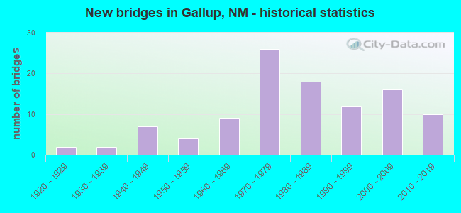
- New bridges - historical statistics
- 21920-1929
- 21930-1939
- 71940-1949
- 41950-1959
- 91960-1969
- 261970-1979
- 181980-1989
- 121990-1999
- 162000-2009
- 102010-2019

- Reconstructed bridges - Historical Statistics
- 31950-1959
- 51960-1969
- 01970-1979
- 31980-1989
- 31990-1999
- 82000-2009


- Bridge Condition - Deck
- 3.8%Very good
- 60.4%Good
- 26.4%Satisfactory
- 7.5%Fair
- 1.9%Poor

- Bridge Condition - Superstructure
- 5.7%Very good
- 54.7%Good
- 26.4%Satisfactory
- 9.4%Fair
- 3.8%Poor

- Bridge Condition - Substructure
- 3.8%Very good
- 50.9%Good
- 28.3%Satisfactory
- 15.1%Fair
- 1.9%Poor

- Bridge Condition - Channel
- 19.7%Very good
- 60.6%Good
- 9.1%Satisfactory
- 9.1%Fair
- 1.5%Poor

- Bridge Condition - Culverts
- 8.8%Very good
- 38.2%Good
- 50.0%Satisfactory
- 2.9%Fair
Find on map >> Show street view
Structure Number: 10045, Location: 100' W 4TH ST/GALLUP (Lat: 35.527142, Lng: -108.745833), Route carried "on" structure: State highway 118, Year Built: 1957, Status: Open, Structure Length: 0.87m (2.85ft), Average Daily Traffic: 7,894 (year 2020), Truck Traffic: 7%, Average Future Daily Traffic: 8,884 (year 2040), Design Load: HS 20, Features Intersected: LITTLE PUERCO
Minimum Vertical Clearance: 30+ m (98+ ft), Kilometerpoint: 35.000, Lanes on structure: 6, Base Highway Network: Yes, Owner: State Highway Agency, Approaching Roadway Width: 19.8m (65.0ft), Skew: 23 degrees, Material/Design: Concrete continuous, Design/Construction: Culvert, Number Of Spans In Main Unit: 3, Length of Maximum Span: 2.4m (7.9ft), Curb or Sidewalk Widths: Left: 0.0m, Right: 3.4m (11.2ft)
Condition: Channel: Satisfactory, Culverts: Good, Operating Rating: 51.8 metric tons, Method Used To Determine Operating Rating: Load Factor (LF), Inventory Rating: 32.4 metric tons, Method Used To Determine Inventory Rating: Load Factor (LF), Structural Evaluation: Better than present minimum criteria, Waterway Adequacy: Somewhat better than minimum adequacy, Approach Roadway Alignment: Equal to present desirable criteria, Designated Inspection Frequency: Every 48 months, Inspection Date: May 2021
Find on map >> Show street view
Structure Number: 10046, Location: BETWEEN 3RD/4TH STR/GALLP (Lat: 35.526617, Lng: -108.744458), Route carried "on" structure: City street 4429, Year Built: 1990, Status: Open, Structure Length: 2.99m (9.81ft), Average Daily Traffic: 1,375 (year 2020), Truck Traffic: 6%, Average Future Daily Traffic: 2,946 (year 2040), Design Load: HS 20, Features Intersected: LITTLE PUERCO
Minimum Vertical Clearance: 30+ m (98+ ft), Kilometerpoint: 1.770, Lanes on structure: 2, Owner: City or Municipal Highway Agency, Approaching Roadway Width: 11.9m (39.0ft), Skew: 5 degrees, Material/Design: Concrete continuous, Design/Construction: Culvert, Number Of Spans In Main Unit: 2, Length of Maximum Span: 3.7m (12.1ft), Curb or Sidewalk Widths: Left: 3.0m (9.8ft), Right: 3.0m (9.8ft)
Condition: Channel: Good, Culverts: Satisfactory, Operating Rating: 47.0 metric tons, Method Used To Determine Operating Rating: Load Factor (LF), Inventory Rating: 32.4 metric tons, Method Used To Determine Inventory Rating: Load Factor (LF), Structural Evaluation: Equal to present minimum criteria, Waterway Adequacy: Equal to present minimum criteria, Approach Roadway Alignment: Equal to present desirable criteria, Designated Inspection Frequency: Every 48 months, Inspection Date: May 2020
Find on map >> Show street view
Structure Number: 6706, Location: 1.0 Mi. E. of I-40/NM118 (Lat: 35.531653, Lng: -108.655047), Route carried "under" structure: Other road 31001, Year Built: 1965, Structure Length: 0. m, Average Daily Traffic: 270 (year 2020), Features Intersected: LOCAL RD TO REHOBETH, Facility Carried by Structure: I-40 EBL/WBL
Minimum Vertical Clearance: 4.19m (13.75ft), Kilometerpoint: 0.000, Lanes on structure: 4, Lanes under structure: 2, Material/Design: Concrete, Design/Construction: Culvert, Length of Maximum Span: 7.7m (25.3ft)
Find on map >> Show street view
Structure Number: 673, Location: 19.9 MI E OF ARIZ ST LINE (Lat: 35.522719, Lng: -108.779472), Route carried "under" structure: County highway 31003, Year Built: 1966, Structure Length: 0. m, Average Daily Traffic: 3,087 (year 2020), Truck Traffic: 20%, Features Intersected: ALLISON RD, Facility Carried by Structure: I-40 E/WBL
Minimum Vertical Clearance: 4.14m (13.58ft), Kilometerpoint: 0.000, Lanes on structure: 4, Lanes under structure: 2, Material/Design: Concrete, Design/Construction: Culvert, Length of Maximum Span: 7.6m (24.9ft)
Find on map >> Show street view
Structure Number: 7384, Location: JCT US-602/NM-118/GALLUP (Lat: 35.524072, Lng: -108.758422), Route carried "under" structure: State highway 118, Year Built: 1974, Structure Length: 0. m, Average Daily Traffic: 7,208 (year 2020), Truck Traffic: 3%, Features Intersected: NM118/BNSF RR/RIO PUERCO, Facility Carried by Structure: US-491
Minimum Vertical Clearance: 6.25m (20.51ft), Kilometerpoint: 33.534, Lanes on structure: 4, Lanes under structure: 4, Material/Design: Steel continuous, Design/Construction: Stringer/Multi-beam, Length of Maximum Span: 48.5m (159.1ft)
Find on map >> Show street view
Structure Number: 7613, Location: 0.8 MI E OF US-491/GALLUP (Lat: 35.530100, Lng: -108.745500), Route carried "under" structure: City street 4424, Year Built: 1980, Structure Length: 0. m, Average Daily Traffic: 243 (year 2020), Truck Traffic: 7%, Features Intersected: THIRD STREET, Facility Carried by Structure: I-40 EBL
Minimum Vertical Clearance: 5.58m (18.31ft), Kilometerpoint: 0.003, Lanes on structure: 2, Lanes under structure: 3, Material/Design: Prestressed concrete, Design/Construction: Stringer/Multi-beam, Length of Maximum Span: 19.2m (63.0ft)
Find on map >> Show street view
Structure Number: 7614, Location: 0.8 MI E OF US-491/GALLUP (Lat: 35.530292, Lng: -108.745578), Route carried "under" structure: City street 4424, Year Built: 1980, Structure Length: 0. m, Average Daily Traffic: 243 (year 2020), Truck Traffic: 7%, Features Intersected: THIRD STREET, Facility Carried by Structure: I-40 WB
Minimum Vertical Clearance: 6.64m (21.78ft), Kilometerpoint: 0.161, Lanes on structure: 2, Lanes under structure: 2, Material/Design: Prestressed concrete, Design/Construction: Stringer/Multi-beam, Length of Maximum Span: 19.2m (63.0ft)
Find on map >> Show street view
Structure Number: 7615, Location: 0.9 MI E OF US-491/GALLUP (Lat: 35.530747, Lng: -108.744003), Route carried "under" structure: City street 610, Year Built: 1980, Structure Length: 0. m, Average Daily Traffic: 4,215 (year 2020), Truck Traffic: 7%, Features Intersected: SECOND STREET, Facility Carried by Structure: I-40 WB
Minimum Vertical Clearance: 6.10m (20.01ft), Kilometerpoint: 2.878, Lanes on structure: 2, Lanes under structure: 2, Material/Design: Prestressed concrete, Design/Construction: Stringer/Multi-beam, Length of Maximum Span: 19.2m (63.0ft)
Find on map >> Show street view
Structure Number: 7616, Location: 0.9 MI E OF US-491/GALLUP (Lat: 35.530503, Lng: -108.743900), Route carried "under" structure: State highway 610, Year Built: 1980, Structure Length: 0. m, Average Daily Traffic: 4,215 (year 2020), Truck Traffic: 7%, Features Intersected: SECOND STREET, Facility Carried by Structure: I-40 EBL
Minimum Vertical Clearance: 4.75m (15.58ft), Kilometerpoint: 2.958, Lanes on structure: 2, Lanes under structure: 3, Material/Design: Prestressed concrete, Design/Construction: Stringer/Multi-beam, Length of Maximum Span: 19.2m (63.0ft)
Find on map >> Show street view
Structure Number: 7618, Location: GALLUP / EXIT 22 (Lat: 35.533278, Lng: -108.726917), Route carried "under" structure: Interstate 40, Year Built: 1978, Structure Length: 0. m, Average Daily Traffic: 29,921 (year 2020), Truck Traffic: 51%, Features Intersected: I-40 EBL/WBL mp 22.75, Facility Carried by Structure: NM-609
Minimum Vertical Clearance: 4.61m (15.12ft), Kilometerpoint: 36.569, Lanes on structure: 4, Lanes under structure: 4, Material/Design: Prestressed concrete, Design/Construction: Stringer/Multi-beam, Length of Maximum Span: 25.9m (85.0ft)
Find on map >> Show street view
Structure Number: 7669, Location: 4.6 MI E OF JCT US-491 (Lat: 35.534372, Lng: -108.680508), Route carried "under" structure: County highway 31001, Year Built: 1978, Structure Length: 0. m, Average Daily Traffic: 270 (year 2020), Features Intersected: COUNTY ROAD, Facility Carried by Structure: I-40 EBL
Minimum Vertical Clearance: 5.03m (16.50ft), Kilometerpoint: 0.053, Lanes on structure: 2, Lanes under structure: 2, Material/Design: Prestressed concrete, Design/Construction: Stringer/Multi-beam, Length of Maximum Span: 20.4m (66.9ft)
Find on map >> Show street view
Structure Number: 767, Location: 4.6 MI E OF JCT US-491 (Lat: 35.534583, Lng: -108.680297), Route carried "under" structure: County highway 31001, Year Built: 1978, Structure Length: 0. m, Average Daily Traffic: 270 (year 2020), Features Intersected: COUNTY ROAD, Facility Carried by Structure: I-40 WBL
Minimum Vertical Clearance: 5.64m (18.50ft), Kilometerpoint: 0.055, Lanes on structure: 2, Lanes under structure: 2, Material/Design: Prestressed concrete, Design/Construction: Stringer/Multi-beam, Length of Maximum Span: 20.4m (66.9ft)
Find on map >> Show street view
Structure Number: 787, Location: 5.0 MI E OF US-491/GALLUP (Lat: 35.531483, Lng: -108.673017), Route carried "under" structure: State highway 118, Year Built: 1980, Structure Length: 0. m, Average Daily Traffic: 8,775 (year 2020), Truck Traffic: 3%, Features Intersected: NM118,BNSF RR,Rio Puerco, Facility Carried by Structure: I-40 EBL
Minimum Vertical Clearance: 8.23m (27.00ft), Kilometerpoint: 41.682, Lanes on structure: 2, Lanes under structure: 6, Material/Design: Prestressed concrete, Design/Construction: Stringer/Multi-beam, Length of Maximum Span: 28.3m (92.8ft)
Find on map >> Show street view
Structure Number: 7871, Location: 5.0 MI E OF US-491 (Lat: 35.531558, Lng: -108.672758), Route carried "under" structure: State highway 118, Year Built: 1980, Structure Length: 0. m, Average Daily Traffic: 8,775 (year 2020), Truck Traffic: 3%, Features Intersected: NM118,BNSF RR,Rio Puerco, Facility Carried by Structure: I-40 WBL
Minimum Vertical Clearance: 7.93m (26.02ft), Kilometerpoint: 41.471, Lanes on structure: 2, Lanes under structure: 6, Material/Design: Prestressed concrete, Design/Construction: Stringer/Multi-beam, Length of Maximum Span: 28.3m (92.8ft)
Find on map >> Show street view
Structure Number: 8835, Location: Jct I-40/NM-118 Gallup (Lat: 35.505600, Lng: -108.830950), Route carried "under" structure: State highway 118, Year Built: 1993, Structure Length: 0. m, Average Daily Traffic: 8,760 (year 2020), Truck Traffic: 3%, Features Intersected: NM-118, Facility Carried by Structure: I-40 WBL
Minimum Vertical Clearance: 4.97m (16.31ft), Kilometerpoint: 0.000, Lanes on structure: 4, Lanes under structure: 4, Material/Design: Steel, Design/Construction: Stringer/Multi-beam, Length of Maximum Span: 48.8m (160.1ft)
Find on map >> Show street view
Structure Number: 8836, Location: West Gallup Interchange (Lat: 35.505658, Lng: -108.830603), Route carried "under" structure: State highway 118, Year Built: 1993, Structure Length: 0. m, Average Daily Traffic: 8,760 (year 2020), Truck Traffic: 3%, Features Intersected: NM-118, Facility Carried by Structure: I-40 EB
Minimum Vertical Clearance: 4.91m (16.11ft), Kilometerpoint: 26.800, Lanes on structure: 4, Lanes under structure: 4, Material/Design: Steel, Design/Construction: Stringer/Multi-beam, Length of Maximum Span: 48.8m (160.1ft)
Find on map >> Show street view
Structure Number: 933, Location: Jct I-40/US-491 mp 20.8 (Lat: 35.528361, Lng: -108.759764), Route carried "under" structure: Interstate 40, Year Built: 2007, Structure Length: 0. m, Average Daily Traffic: 20,514 (year 2020), Truck Traffic: 51%, Features Intersected: I-40 EB and WB @ 20.8, Facility Carried by Structure: US-491 NB and SB
Minimum Vertical Clearance: 4.97m (16.31ft), Kilometerpoint: 33.474, Lanes on structure: 4, Lanes under structure: 4, Material/Design: Prestressed concrete continuous, Design/Construction: Stringer/Multi-beam, Length of Maximum Span: 29.0m (95.1ft)
Find on map >> Show street view
Structure Number: 9343, Location: 12.7 M E of NM/Ariz Line (Lat: 35.488756, Lng: -108.892397), Route carried "under" structure: State highway 118, Year Built: 2007, Structure Length: 0. m, Average Daily Traffic: 638 (year 2020), Truck Traffic: 21%, Features Intersected: NM-118, Facility Carried by Structure: I-40 EBL
Minimum Vertical Clearance: 5.18m (16.99ft), Kilometerpoint: 20.411, Lanes on structure: 3, Lanes under structure: 2, Material/Design: Concrete continuous, Design/Construction: Slab, Length of Maximum Span: 12.2m (40.0ft)
Find on map >> Show street view
Structure Number: 9344, Location: 12.7 Mi E of NM/AZ Line (Lat: 35.489058, Lng: -108.892514), Route carried "under" structure: State highway 118, Year Built: 2007, Structure Length: 0. m, Average Daily Traffic: 1,982 (year 2020), Truck Traffic: 21%, Features Intersected: NM-118, Facility Carried by Structure: I-40 WB
Minimum Vertical Clearance: 5.27m (17.29ft), Kilometerpoint: 20.411, Lanes on structure: 2, Lanes under structure: 2, Material/Design: Concrete continuous, Design/Construction: Slab, Length of Maximum Span: 12.2m (40.0ft)
Find on map >> Show street view
Structure Number: 9345, Location: 15.3 Mi E of NM/AZ Line (Lat: 35.498225, Lng: -108.847656), Route carried "under" structure: County highway 30032, Year Built: 2007, Structure Length: 0. m, Average Daily Traffic: 270 (year 2020), Features Intersected: County Road 20, Facility Carried by Structure: I-40 WB
Minimum Vertical Clearance: 5.27m (17.29ft), Kilometerpoint: 0.039, Lanes on structure: 2, Lanes under structure: 2, Material/Design: Concrete continuous, Design/Construction: Slab, Length of Maximum Span: 12.2m (40.0ft)
Find on map >> Show street view
Structure Number: 9346, Location: 15.3 Mi E of NM/Ariz Line (Lat: 35.498033, Lng: -108.847619), Route carried "under" structure: County highway 30032, Year Built: 2007, Structure Length: 0. m, Average Daily Traffic: 270 (year 2020), Features Intersected: County Road 20, Facility Carried by Structure: I-40 EB
Minimum Vertical Clearance: 4.94m (16.21ft), Kilometerpoint: 0.039, Lanes on structure: 2, Lanes under structure: 2, Material/Design: Concrete continuous, Design/Construction: Slab, Length of Maximum Span: 12.2m (40.0ft)