Bridge Statistics for Garner, North Carolina (NC)
Condition, Traffic, Stress, Structural Evaluation, Project Costs
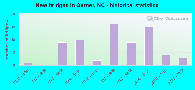
- New bridges - historical statistics
- 11930-1939
- 91950-1959
- 101960-1969
- 21970-1979
- 161980-1989
- 91990-1999
- 152000-2009
- 42010-2019
- 32020-2022
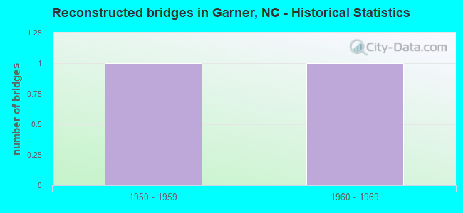
- Reconstructed bridges - Historical Statistics
- 11950-1959
- 11960-1969
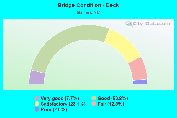
- Bridge Condition - Deck
- 7.7%Very good
- 53.8%Good
- 23.1%Satisfactory
- 12.8%Fair
- 2.6%Poor
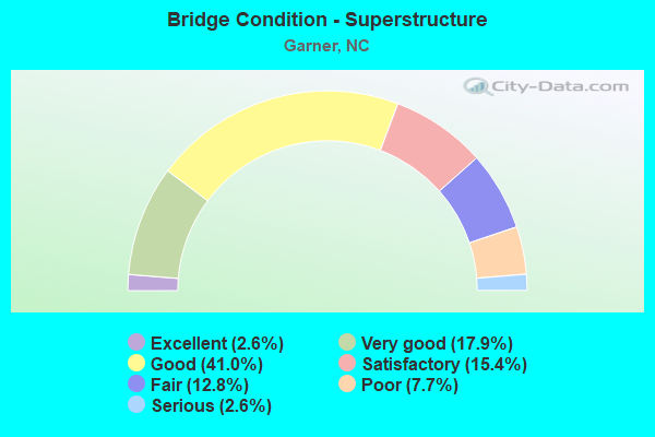
- Bridge Condition - Superstructure
- 2.6%Excellent
- 17.9%Very good
- 41.0%Good
- 15.4%Satisfactory
- 12.8%Fair
- 7.7%Poor
- 2.6%Serious
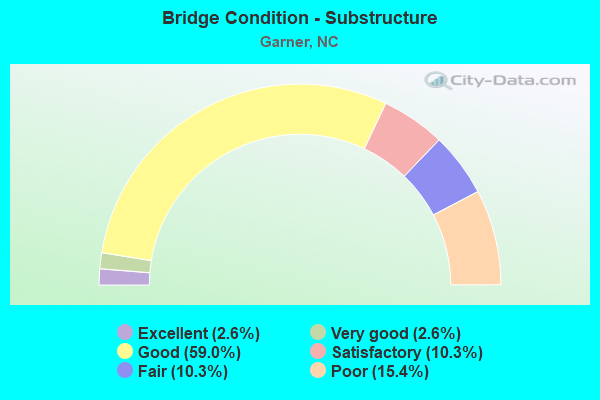
- Bridge Condition - Substructure
- 2.6%Excellent
- 2.6%Very good
- 59.0%Good
- 10.3%Satisfactory
- 10.3%Fair
- 15.4%Poor
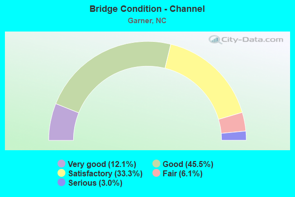
- Bridge Condition - Channel
- 12.1%Very good
- 45.5%Good
- 33.3%Satisfactory
- 6.1%Fair
- 3.0%Serious
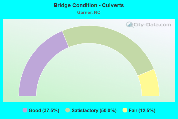
- Bridge Condition - Culverts
- 37.5%Good
- 50.0%Satisfactory
- 12.5%Fair
Find on map >> Show street view
Structure Number: 183108, Location: 0.7 MI. WEST OF SR 1117 (Lat: 35.591333, Lng: -78.914278), Route carried "on" structure: State highway 1116, Year Built: 1980, Status: Open, Structure Length: 3.65m (11.98ft), Average Daily Traffic: 1,300 (year 2019), Truck Traffic: 7%, Average Future Daily Traffic: 2,600 (year 2040), Design Load: HS 20+Mod, Features Intersected: BUCKHORN CREEK
Minimum Vertical Clearance: 30+ m (98+ ft), Kilometerpoint: 0.000, Lanes on structure: 2, Owner: State Highway Agency, Approaching Roadway Width: 6.4m (21.0ft), Material/Design: Prestressed concrete, Design/Construction: Slab, Number Of Spans In Main Unit: 3, Length of Maximum Span: 11.8m (38.7ft), Curb-To-Curb Width: 7.1m (23.3ft), Out-to-Out Width: 8.2m (26.9ft)
Condition: Deck: Good, Superstructure: Good, Substructure: Good, Channel: Satisfactory, Operating Rating: 89.8 metric tons, Method Used To Determine Operating Rating: Load Factor (LF), Inventory Rating: 58.0 metric tons, Method Used To Determine Inventory Rating: Load Factor (LF), Structural Evaluation: Better than present minimum criteria, Deck Geometry: High priority of corrective action, Waterway Adequacy: Better than present minimum criteria, Approach Roadway Alignment: Better than present minimum criteria, Designated Inspection Frequency: Every 24 months, Underwater Inspection Frequency: Every 60 months, Inspection Date: June 2021, Underwater Inspection Date: July 2021, Deck Structure Type: Concrete Precast Panels, Wearing Surface/Protective System: Wearing Surface: Bituminous
Find on map >> Show street view
Structure Number: 1831087, Location: 0.35 MI. W.JCT. US70W.RMP (Lat: 35.637394, Lng: -78.566019), Route carried "on" structure: Ramp Interstate 40, Year Built: 2008, Status: Open, Structure Length: 23.28m (76.38ft), Average Daily Traffic: 18,250 (year 2018), Truck Traffic: 16%, Average Future Daily Traffic: 36,500 (year 2040), Design Load: HS 20+Mod, Features Intersected: I40,SWIFT CREEK
Minimum Vertical Clearance: 30+ m (98+ ft), Kilometerpoint: 96.927, Lanes on structure: 1, Lanes under structure: 6, Base Highway Network: Yes, Owner: State Highway Agency, Approaching Roadway Width: 9.4m (30.8ft), Material/Design: Steel continuous, Design/Construction: Stringer/Multi-beam, Number Of Spans In Main Unit: 4, Length of Maximum Span: 61.5m (201.8ft), Curb-To-Curb Width: 8.9m (29.2ft), Out-to-Out Width: 10.0m (32.8ft)
Condition: Deck: Good, Superstructure: Good, Substructure: Good, Channel: Very good, Operating Rating: 68.0 metric tons, Method Used To Determine Operating Rating: Load Factor (LF), Inventory Rating: 40.8 metric tons, Method Used To Determine Inventory Rating: Load Factor (LF), Structural Evaluation: Better than present minimum criteria, Deck Geometry: High priority of corrective action, Underclear: High priority of corrective action, Waterway Adequacy: Superior to present desirable criteria, Approach Roadway Alignment: Equal to present desirable criteria, Designated Inspection Frequency: Every 24 months, Inspection Date: May 2020, Deck Structure Type: Concrete Cast-file-Place, Wearing Surface/Protective System: Wearing Surface: Monolithic Concrete, Deck Protection: Epoxy Coated Reinforcing
Find on map >> Show street view
Structure Number: 1831088, Location: 0.73 MI. E. JCT. I-40E (Lat: 35.636614, Lng: -78.566075), Route carried "on" structure: Ramp US 70, Year Built: 2008, Status: Open, Structure Length: 28.19m (92.49ft), Average Daily Traffic: 18,250 (year 2018), Truck Traffic: 12%, Average Future Daily Traffic: 36,500 (year 2040), Design Load: HS 20+Mod, Features Intersected: I40,SWIFT CREEK
Minimum Vertical Clearance: 30+ m (98+ ft), Kilometerpoint: 0.000, Lanes on structure: 2, Lanes under structure: 6, Owner: State Highway Agency, Approaching Roadway Width: 12.8m (42.0ft), Material/Design: Steel continuous, Design/Construction: Stringer/Multi-beam, Number Of Spans In Main Unit: 5, Length of Maximum Span: 66.4m (217.8ft), Curb-To-Curb Width: 12.0m (39.4ft), Out-to-Out Width: 12.9m (42.3ft)
Condition: Deck: Satisfactory, Superstructure: Good, Substructure: Good, Channel: Very good, Operating Rating: 71.6 metric tons, Method Used To Determine Operating Rating: Load Factor (LF), Inventory Rating: 42.6 metric tons, Method Used To Determine Inventory Rating: Load Factor (LF), Structural Evaluation: Better than present minimum criteria, Deck Geometry: Superior to present desirable criteria, Underclear: High priority of corrective action, Waterway Adequacy: Superior to present desirable criteria, Approach Roadway Alignment: Equal to present desirable criteria, Designated Inspection Frequency: Every 24 months, Inspection Date: May 2020, Deck Structure Type: Concrete Cast-file-Place, Wearing Surface/Protective System: Wearing Surface: Monolithic Concrete, Deck Protection: Epoxy Coated Reinforcing
Find on map >> Show street view
Structure Number: 1831205, Location: .4 MI. E. OF HWY50 (Lat: 35.686806, Lng: -78.597111), Route carried "on" structure: State highway 2812, Year Built: 2011, Status: Open, Structure Length: 11.27m (36.98ft), Average Daily Traffic: 10,000 (year 2019), Truck Traffic: 6%, Average Future Daily Traffic: 20,000 (year 2040), Design Load: HS 20+Mod, Features Intersected: MAHLER'S CREEK
Minimum Vertical Clearance: 30+ m (98+ ft), Kilometerpoint: 0.000, Lanes on structure: 2, Owner: State Highway Agency, Approaching Roadway Width: 9.1m (29.9ft), Skew: 11 degrees, Material/Design: Prestressed concrete continuous, Design/Construction: Stringer/Multi-beam, Number Of Spans In Main Unit: 4, Length of Maximum Span: 27.4m (89.9ft), Curb or Sidewalk Widths: Left: 0.0m, Right: 1.7m (5.6ft), Curb-To-Curb Width: 9.0m (29.5ft), Out-to-Out Width: 11.7m (38.4ft)
Condition: Deck: Good, Superstructure: Very good, Substructure: Good, Channel: Good, Operating Rating: 89.8 metric tons, Method Used To Determine Operating Rating: Load Factor (LF), Inventory Rating: 55.3 metric tons, Method Used To Determine Inventory Rating: Load Factor (LF), Structural Evaluation: Better than present minimum criteria, Deck Geometry: High priority of corrective action, Waterway Adequacy: Better than present minimum criteria, Approach Roadway Alignment: Equal to present desirable criteria, Designated Inspection Frequency: Every 24 months, Inspection Date: July 2021, Deck Structure Type: Concrete Cast-file-Place, Wearing Surface/Protective System: Wearing Surface: Monolithic Concrete, Deck Protection: Epoxy Coated Reinforcing
Find on map >> Show street view
Structure Number: 1831206, Location: 0.4 MI. E. JCT. NC50 (Lat: 35.686803, Lng: -78.597108), Route carried "on" structure: State highway 2812, Year Built: 2011, Status: Open, Structure Length: 11.27m (36.98ft), Average Daily Traffic: 10,000 (year 2019), Truck Traffic: 6%, Average Future Daily Traffic: 20,000 (year 2040), Design Load: HS 20+Mod, Features Intersected: MAHLER'S CREEK
Minimum Vertical Clearance: 30+ m (98+ ft), Kilometerpoint: 0.000, Lanes on structure: 2, Owner: State Highway Agency, Approaching Roadway Width: 9.1m (29.9ft), Skew: 11 degrees, Material/Design: Prestressed concrete continuous, Design/Construction: Stringer/Multi-beam, Number Of Spans In Main Unit: 4, Length of Maximum Span: 27.4m (89.9ft), Curb or Sidewalk Widths: Left: 1.7m (5.6ft), Right: 0.0m, Curb-To-Curb Width: 9.0m (29.5ft), Out-to-Out Width: 11.7m (38.4ft)
Condition: Deck: Good, Superstructure: Very good, Substructure: Good, Channel: Good, Operating Rating: 89.8 metric tons, Method Used To Determine Operating Rating: Load Factor (LF), Inventory Rating: 55.3 metric tons, Method Used To Determine Inventory Rating: Load Factor (LF), Structural Evaluation: Better than present minimum criteria, Deck Geometry: High priority of corrective action, Waterway Adequacy: Better than present minimum criteria, Approach Roadway Alignment: Equal to present desirable criteria, Designated Inspection Frequency: Every 24 months, Inspection Date: July 2021, Deck Structure Type: Concrete Cast-file-Place, Wearing Surface/Protective System: Wearing Surface: Monolithic Concrete, Deck Protection: Epoxy Coated Reinforcing
Find on map >> Show street view
Structure Number: 1010499, Location: 0.7MI.E.SR1524 (Lat: 35.573911, Lng: -78.576375), Route carried "under" structure: Interstate 40, Year Built: 1987, Structure Length: 0. m, Average Daily Traffic: 26,500 (year 2019), Truck Traffic: 16%, Features Intersected: SR1525
Minimum Vertical Clearance: 5.00m (16.40ft), Kilometerpoint: 95.769, Lanes on structure: 2, Lanes under structure: 2, Material/Design: Prestressed concrete, Design/Construction: Stringer/Multi-beam, Length of Maximum Span: 18.8m (61.7ft)
Find on map >> Show street view
Structure Number: 1010499, Location: 0.7MI.E.SR1524 (Lat: 35.573911, Lng: -78.576375), Route carried "under" structure: Interstate 40, Year Built: 1987, Structure Length: 0. m, Average Daily Traffic: 26,500 (year 2019), Truck Traffic: 16%, Features Intersected: SR1525
Minimum Vertical Clearance: 5.18m (16.99ft), Kilometerpoint: 95.769, Lanes on structure: 2, Lanes under structure: 2, Material/Design: Prestressed concrete, Design/Construction: Stringer/Multi-beam, Length of Maximum Span: 18.8m (61.7ft)
Find on map >> Show street view
Structure Number: 1830069, Location: 0.3 MI. S. JCT. SR1004 (Lat: 35.706333, Lng: -78.613308), Route carried "under" structure: US 70, Year Built: 1952, Structure Length: 0. m, Average Daily Traffic: 14,750 (year 2019), Truck Traffic: 12%, Features Intersected: NC50
Minimum Vertical Clearance: 4.37m (14.34ft), Kilometerpoint: 0.000, Lanes on structure: 3, Lanes under structure: 2, Material/Design: Steel, Design/Construction: Stringer/Multi-beam, Length of Maximum Span: 19.8m (65.0ft)
Find on map >> Show street view
Structure Number: 1830069, Location: 0.3 MI. S. JCT. SR1004 (Lat: 35.706333, Lng: -78.613308), Route carried "under" structure: US 70, Year Built: 1952, Structure Length: 0. m, Average Daily Traffic: 14,750 (year 2019), Truck Traffic: 12%, Features Intersected: NC50
Minimum Vertical Clearance: 4.67m (15.32ft), Kilometerpoint: 0.000, Lanes on structure: 3, Lanes under structure: 2, Material/Design: Steel, Design/Construction: Stringer/Multi-beam, Length of Maximum Span: 19.8m (65.0ft)
Find on map >> Show street view
Structure Number: 1830258, Location: 0.22 MI. S. JCT. SR1004 (Lat: 35.710686, Lng: -78.622975), Route carried "under" structure: US 70, Year Built: 1962, Structure Length: 0. m, Average Daily Traffic: 18,000 (year 2019), Truck Traffic: 12%, Features Intersected: SR2713
Minimum Vertical Clearance: 4.41m (14.47ft), Kilometerpoint: 0.000, Lanes on structure: 2, Lanes under structure: 3, Material/Design: Steel, Design/Construction: Stringer/Multi-beam, Length of Maximum Span: 18.8m (61.7ft)
Find on map >> Show street view
Structure Number: 1830258, Location: 0.22 MI. S. JCT. SR1004 (Lat: 35.710686, Lng: -78.622975), Route carried "under" structure: US 70, Year Built: 1962, Structure Length: 0. m, Average Daily Traffic: 18,000 (year 2019), Truck Traffic: 12%, Features Intersected: SR2713
Minimum Vertical Clearance: 4.76m (15.62ft), Kilometerpoint: 0.000, Lanes on structure: 2, Lanes under structure: 3, Material/Design: Steel, Design/Construction: Stringer/Multi-beam, Length of Maximum Span: 18.8m (61.7ft)
Find on map >> Show street view
Structure Number: 1830605, Location: 1.0 MI.E.NC50 (Lat: 35.694586, Lng: -78.575083), Route carried "under" structure: US 70, Year Built: 1986, Structure Length: 0. m, Average Daily Traffic: 20,000 (year 2019), Truck Traffic: 12%, Features Intersected: I40E
Minimum Vertical Clearance: 5.24m (17.19ft), Kilometerpoint: 0.000, Lanes on structure: 3, Lanes under structure: 2, Material/Design: Steel, Design/Construction: Stringer/Multi-beam, Length of Maximum Span: 31.0m (101.7ft)
Find on map >> Show street view
Structure Number: 1830605, Location: 1.0 MI.E.NC50 (Lat: 35.694586, Lng: -78.575083), Route carried "under" structure: US 70, Year Built: 1986, Structure Length: 0. m, Average Daily Traffic: 20,000 (year 2019), Truck Traffic: 12%, Features Intersected: I40E
Minimum Vertical Clearance: 5.45m (17.88ft), Kilometerpoint: 0.000, Lanes on structure: 3, Lanes under structure: 3, Material/Design: Steel, Design/Construction: Stringer/Multi-beam, Length of Maximum Span: 31.0m (101.7ft)
Find on map >> Show street view
Structure Number: 1830606, Location: 0.1 MI. E. JCT. US70 (Lat: 35.691342, Lng: -78.573217), Route carried "under" structure: Ramp US 70, Year Built: 1986, Structure Length: 0. m, Average Daily Traffic: 11,500 (year 2019), Truck Traffic: 16%, Features Intersected: I40E
Minimum Vertical Clearance: 5.81m (19.06ft), Kilometerpoint: 0.000, Lanes on structure: 3, Lanes under structure: 2, Material/Design: Steel, Design/Construction: Stringer/Multi-beam, Length of Maximum Span: 17.0m (55.8ft)
Find on map >> Show street view
Structure Number: 1830612, Location: 0.5 MI. E. JCT. SR2704 (Lat: 35.644719, Lng: -78.565450), Route carried "under" structure: Ramp US 70, Year Built: 2008, Structure Length: 0. m, Average Daily Traffic: 18,250 (year 2018), Truck Traffic: 12%, Features Intersected: SR2703
Minimum Vertical Clearance: 6.47m (21.23ft), Kilometerpoint: 0.000, Lanes on structure: 2, Lanes under structure: 2, Material/Design: Steel continuous, Design/Construction: Stringer/Multi-beam, Length of Maximum Span: 40.5m (132.9ft)
Find on map >> Show street view
Structure Number: 1830612, Location: 0.5 MI. E. JCT. SR2704 (Lat: 35.644719, Lng: -78.565450), Route carried "under" structure: Interstate 40, Year Built: 2008, Structure Length: 0. m, Average Daily Traffic: 32,500 (year 2018), Truck Traffic: 16%, Features Intersected: SR2703
Minimum Vertical Clearance: 5.96m (19.55ft), Kilometerpoint: 94.245, Lanes on structure: 2, Lanes under structure: 2, Material/Design: Steel continuous, Design/Construction: Stringer/Multi-beam, Length of Maximum Span: 40.5m (132.9ft)
Find on map >> Show street view
Structure Number: 1830612, Location: 0.5 MI. E. JCT. SR2704 (Lat: 35.644719, Lng: -78.565450), Route carried "under" structure: Interstate 40, Year Built: 2008, Structure Length: 0. m, Average Daily Traffic: 32,500 (year 2018), Truck Traffic: 16%, Features Intersected: SR2703
Minimum Vertical Clearance: 5.48m (17.98ft), Kilometerpoint: 94.245, Lanes on structure: 2, Lanes under structure: 3, Material/Design: Steel continuous, Design/Construction: Stringer/Multi-beam, Length of Maximum Span: 40.5m (132.9ft)
Find on map >> Show street view
Structure Number: 1830616, Location: .37 MI E. JCT. SR 5220 (Lat: 35.702517, Lng: -78.582253), Route carried "under" structure: Interstate 40, Year Built: 2020, Structure Length: 0. m, Average Daily Traffic: 55,000 (year 2018), Truck Traffic: 16%, Features Intersected: SR1004
Minimum Vertical Clearance: 6.45m (21.16ft), Kilometerpoint: 0.000, Lanes on structure: 2, Lanes under structure: 3, Material/Design: Prestressed concrete, Design/Construction: Stringer/Multi-beam, Length of Maximum Span: 43.5m (142.7ft)
Find on map >> Show street view
Structure Number: 1830618, Location: 0.1 MI.E.SR2547 (Lat: 35.695467, Lng: -78.579022), Route carried "under" structure: Ramp US 70, Year Built: 1987, Structure Length: 0. m, Average Daily Traffic: 20,000 (year 2019), Truck Traffic: 12%, Features Intersected: US70 W
Minimum Vertical Clearance: 5.63m (18.47ft), Kilometerpoint: 0.000, Lanes on structure: 2, Lanes under structure: 2, Material/Design: Steel, Design/Construction: Stringer/Multi-beam, Length of Maximum Span: 17.3m (56.8ft)
Find on map >> Show street view
Structure Number: 1830619, Location: 0.1 MI. E. JCT. SR2547 (Lat: 35.695308, Lng: -78.578997), Route carried "under" structure: Ramp US 70, Year Built: 1987, Structure Length: 0. m, Average Daily Traffic: 36,000 (year 2018), Truck Traffic: 16%, Features Intersected: US70E
Minimum Vertical Clearance: 5.43m (17.81ft), Kilometerpoint: 0.000, Lanes on structure: 3, Lanes under structure: 2, Material/Design: Steel, Design/Construction: Stringer/Multi-beam, Length of Maximum Span: 17.3m (56.8ft)
Find on map >> Show street view
Structure Number: 1830651, Location: 0.7M. N. WATERFIELD DR. (Lat: 35.689911, Lng: -78.557442), Route carried "under" structure: US 70, Year Built: 1990, Structure Length: 0. m, Average Daily Traffic: 23,000 (year 2019), Truck Traffic: 12%, Features Intersected: SR4142
Minimum Vertical Clearance: 5.06m (16.60ft), Kilometerpoint: 0.000, Lanes on structure: 4, Lanes under structure: 3, Material/Design: Steel, Design/Construction: Stringer/Multi-beam, Length of Maximum Span: 23.1m (75.8ft)
Find on map >> Show street view
Structure Number: 1830651, Location: 0.7M. N. WATERFIELD DR. (Lat: 35.689911, Lng: -78.557442), Route carried "under" structure: US 70, Year Built: 1990, Structure Length: 0. m, Average Daily Traffic: 23,000 (year 2019), Truck Traffic: 12%, Features Intersected: SR4142
Minimum Vertical Clearance: 5.15m (16.90ft), Kilometerpoint: 0.000, Lanes on structure: 4, Lanes under structure: 3, Material/Design: Steel, Design/Construction: Stringer/Multi-beam, Length of Maximum Span: 23.1m (75.8ft)
Find on map >> Show street view
Structure Number: 1831087, Location: 0.35 MI. W.JCT. US70W.RMP (Lat: 35.637394, Lng: -78.566019), Route carried "under" structure: Interstate 40, Year Built: 2008, Structure Length: 0. m, Average Daily Traffic: 32,500 (year 2018), Truck Traffic: 16%, Features Intersected: I40E RAMP, US70W
Minimum Vertical Clearance: 5.48m (17.98ft), Kilometerpoint: 94.397, Lanes on structure: 1, Lanes under structure: 2, Material/Design: Steel continuous, Design/Construction: Stringer/Multi-beam, Length of Maximum Span: 61.5m (201.8ft)
Find on map >> Show street view
Structure Number: 1831087, Location: 0.35 MI. W.JCT. US70W.RMP (Lat: 35.637394, Lng: -78.566019), Route carried "under" structure: Interstate 40, Year Built: 2008, Structure Length: 0. m, Average Daily Traffic: 32,500 (year 2018), Truck Traffic: 16%, Features Intersected: I40E RAMP, US70W
Minimum Vertical Clearance: 5.71m (18.73ft), Kilometerpoint: 94.397, Lanes on structure: 1, Lanes under structure: 4, Material/Design: Steel continuous, Design/Construction: Stringer/Multi-beam, Length of Maximum Span: 61.5m (201.8ft)
Find on map >> Show street view
Structure Number: 1831088, Location: 0.73 MI. E. JCT. I-40E (Lat: 35.636614, Lng: -78.566075), Route carried "under" structure: Interstate 40, Year Built: 2008, Structure Length: 0. m, Average Daily Traffic: 32,500 (year 2018), Truck Traffic: 16%, Features Intersected: US70E BYP.
Minimum Vertical Clearance: 5.48m (17.98ft), Kilometerpoint: 94.397, Lanes on structure: 2, Lanes under structure: 4, Material/Design: Steel continuous, Design/Construction: Stringer/Multi-beam, Length of Maximum Span: 66.4m (217.8ft)
Find on map >> Show street view
Structure Number: 1831088, Location: 0.73 MI. E. JCT. I-40E (Lat: 35.636614, Lng: -78.566075), Route carried "under" structure: Interstate 40, Year Built: 2008, Structure Length: 0. m, Average Daily Traffic: 32,500 (year 2018), Truck Traffic: 16%, Features Intersected: US70E BYP.
Minimum Vertical Clearance: 5.37m (17.62ft), Kilometerpoint: 94.397, Lanes on structure: 2, Lanes under structure: 2, Material/Design: Steel continuous, Design/Construction: Stringer/Multi-beam, Length of Maximum Span: 66.4m (217.8ft)