Bridge Statistics for Golden, Colorado (CO)
Condition, Traffic, Stress, Structural Evaluation, Project Costs
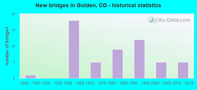
- New bridges - historical statistics
- 11940-1949
- 181960-1969
- 51970-1979
- 91980-1989
- 121990-1999
- 52000-2009
- 52010-2019
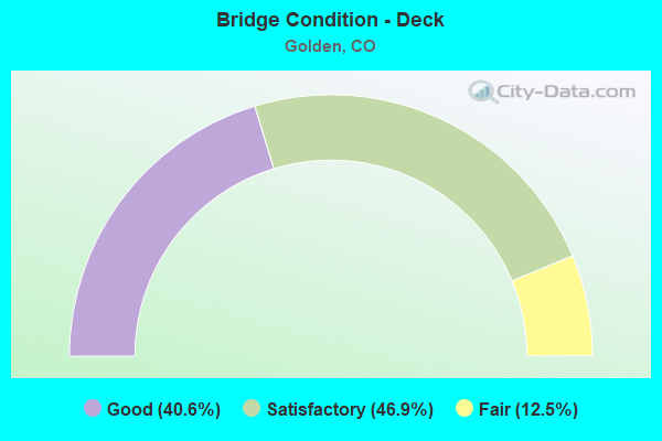
- Bridge Condition - Deck
- 40.6%Good
- 46.9%Satisfactory
- 12.5%Fair
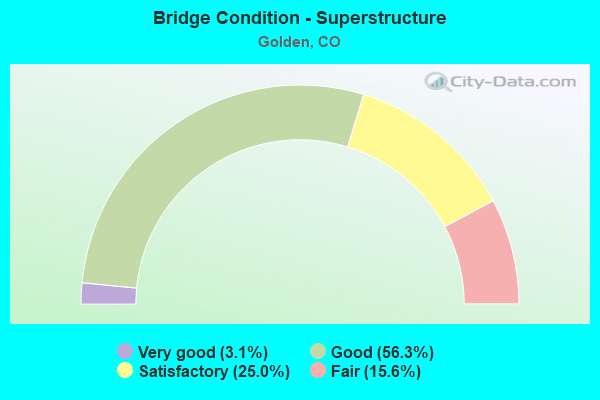
- Bridge Condition - Superstructure
- 3.1%Very good
- 56.3%Good
- 25.0%Satisfactory
- 15.6%Fair
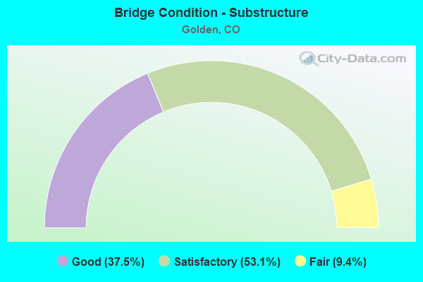
- Bridge Condition - Substructure
- 37.5%Good
- 53.1%Satisfactory
- 9.4%Fair
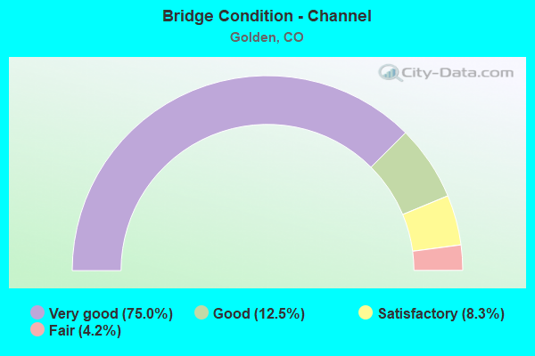
- Bridge Condition - Channel
- 75.0%Very good
- 12.5%Good
- 8.3%Satisfactory
- 4.2%Fair
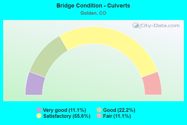
- Bridge Condition - Culverts
- 11.1%Very good
- 22.2%Good
- 55.6%Satisfactory
- 11.1%Fair
Find on map >> Show street view
Structure Number: GLDN-09-0.01-01, Location: 1.5 BLOCKS SE OF HWY 93 (Lat: 39.772397, Lng: -105.234978), Route carried "on" structure: City street , Year Built: 2005, Status: Open, Structure Length: 1.12m (3.67ft), Average Daily Traffic: 548 (year 2021), Truck Traffic: 1%, Average Future Daily Traffic: 630 (year 2041), Design Load: HS 20, Features Intersected: TUCKER GULCH, Facility Carried by Structure: JOSEPH CIRCLE
Minimum Vertical Clearance: 30+ m (98+ ft), Kilometerpoint: 0.021, Lanes on structure: 2, Owner: City or Municipal Highway Agency, Approaching Roadway Width: 9.8m (32.2ft), Skew: 1 degrees, Material/Design: Steel, Design/Construction: Culvert, Number Of Spans In Main Unit: 1, Length of Maximum Span: 11.2m (36.7ft), Curb or Sidewalk Widths: Left: 3.1m (10.2ft), Right: 0.0m, Out-to-Out Width: 31.1m (102.0ft)
Condition: Channel: Very good, Culverts: Good, Structural Evaluation: Better than present minimum criteria, Waterway Adequacy: Equal to present desirable criteria, Approach Roadway Alignment: Equal to present desirable criteria, Designated Inspection Frequency: Every 24 months, Inspection Date: April 2021
Find on map >> Show street view
Structure Number: E-16-XR, Location: IN GOLDEN (Lat: 39.760103, Lng: -105.225583), Route carried "under" structure: State highway 58A, Year Built: 2010, Structure Length: 0. m, Average Daily Traffic: 12,408 (year 2016), Truck Traffic: 11%, Features Intersected: SH 58 ML, Facility Carried by Structure: WASHINGTON STREET
Minimum Vertical Clearance: 6.10m (20.01ft), Kilometerpoint: 1.811, Lanes on structure: 5, Lanes under structure: 4, Material/Design: Prestressed concrete continuous, Design/Construction: Box Beam or Girders - Multiple, Length of Maximum Span: 20.9m (68.6ft)
Find on map >> Show street view
Structure Number: F-16-AS, Location: 1.2 MI E OF C470 (Lat: 39.725086, Lng: -105.179322), Route carried "under" structure: US 6G, Year Built: 1969, Structure Length: 0. m, Average Daily Traffic: 30,000 (year 2011), Truck Traffic: 4%, Features Intersected: US 6 ML AND RAMP, Facility Carried by Structure: I 70 ML EBND
Minimum Vertical Clearance: 5.21m (17.09ft), Kilometerpoint: 443.522, Lanes on structure: 3, Lanes under structure: 5, Material/Design: Concrete continuous, Design/Construction: Box Beam or Girders - Multiple, Length of Maximum Span: 32.0m (105.0ft)
Find on map >> Show street view
Structure Number: F-16-AT, Location: 0.6 MI W OF JCT US 40 (Lat: 39.725042, Lng: -105.179928), Route carried "under" structure: US 6G, Year Built: 1969, Structure Length: 0. m, Average Daily Traffic: 30,000 (year 2011), Truck Traffic: 4%, Features Intersected: US 6 ML, Facility Carried by Structure: I 70 ML WBND
Minimum Vertical Clearance: 5.51m (18.08ft), Kilometerpoint: 443.521, Lanes on structure: 3, Lanes under structure: 5, Material/Design: Concrete continuous, Design/Construction: Box Beam or Girders - Multiple, Length of Maximum Span: 36.0m (118.1ft)
Find on map >> Show street view
Structure Number: F-16-GS, Location: Morrison-Red Rocks Int. (Lat: 39.698708, Lng: -105.204672), Route carried "under" structure: County highway , Year Built: 1969, Structure Length: 0. m, Average Daily Traffic: 7,200 (year 2008), Truck Traffic: 4%, Features Intersected: COUNTY RD 93, Facility Carried by Structure: I 70 ML EBND
Minimum Vertical Clearance: 5.95m (19.52ft), Kilometerpoint: 0.000, Lanes on structure: 3, Lanes under structure: 4, Material/Design: Concrete continuous, Design/Construction: Box Beam or Girders - Single/Spread, Length of Maximum Span: 29.9m (98.1ft)
Find on map >> Show street view
Structure Number: F-16-GT, Location: MORRISON INTCHNG (Lat: 39.699167, Lng: -105.204803), Route carried "under" structure: County highway , Year Built: 1969, Structure Length: 0. m, Average Daily Traffic: 7,200 (year 2008), Truck Traffic: 4%, Features Intersected: COUNTY RD. 93, Facility Carried by Structure: I 70 ML WBND
Minimum Vertical Clearance: 5.44m (17.85ft), Kilometerpoint: 0.000, Lanes on structure: 3, Lanes under structure: 5, Material/Design: Concrete continuous, Design/Construction: Box Beam or Girders - Multiple, Length of Maximum Span: 30.0m (98.4ft)
Find on map >> Show street view
Structure Number: F-16-HQ, Location: W side of C470 I70 INT. (Lat: 39.711431, Lng: -105.194244), Route carried "under" structure: Interstate 70A, Year Built: 1969, Structure Length: 0. m, Average Daily Traffic: 2,246 (year 2016), Truck Traffic: 7%, Features Intersected: I 70 ML, Facility Carried by Structure: ROONEY ROAD
Minimum Vertical Clearance: 6.15m (20.18ft), Kilometerpoint: 3.088, Lanes on structure: 2, Lanes under structure: 8, Material/Design: Concrete continuous, Design/Construction: Box Beam or Girders - Multiple, Length of Maximum Span: 33.5m (109.9ft)
Find on map >> Show street view
Structure Number: F-16-HS, Location: 0.8MI W OF INDIANA ST (Lat: 39.725614, Lng: -105.182733), Route carried "under" structure: US 6G, Year Built: 1969, Structure Length: 0. m, Average Daily Traffic: 30,700 (year 2005), Truck Traffic: 4%, Features Intersected: US 6 ML, Facility Carried by Structure: I 70 WB RAMP
Minimum Vertical Clearance: 6.07m (19.91ft), Kilometerpoint: 443.188, Lanes on structure: 1, Lanes under structure: 4, Material/Design: Concrete continuous, Design/Construction: Box Beam or Girders - Multiple, Length of Maximum Span: 35.7m (117.1ft)
Find on map >> Show street view
Structure Number: F-16-KW, Location: JCT. I70 & 470 (Lat: 39.712758, Lng: -105.194433), Route carried "under" structure: Interstate 70A, Year Built: 1987, Structure Length: 0. m, Average Daily Traffic: 90,000 (year 2011), Truck Traffic: 7%, Features Intersected: I 70 ML, Facility Carried by Structure: SH 470 ML WBND
Minimum Vertical Clearance: 5.97m (19.59ft), Kilometerpoint: 418.066, Lanes on structure: 4, Lanes under structure: 8, Material/Design: Steel continuous, Design/Construction: Stringer/Multi-beam, Length of Maximum Span: 47.2m (154.9ft)
Find on map >> Show street view
Structure Number: F-16-KX, Location: I 70 AND SH 470 INTERSECT (Lat: 39.712239, Lng: -105.194856), Route carried "under" structure: Interstate 70A, Year Built: 1987, Structure Length: 0. m, Average Daily Traffic: 90,000 (year 2011), Truck Traffic: 7%, Features Intersected: I 70 ML, Facility Carried by Structure: SH 470 ML EBND
Minimum Vertical Clearance: 5.74m (18.83ft), Kilometerpoint: 418.050, Lanes on structure: 3, Lanes under structure: 8, Material/Design: Prestressed concrete continuous, Design/Construction: Stringer/Multi-beam, Length of Maximum Span: 42.1m (138.1ft)
Find on map >> Show street view
Structure Number: F-16-KZ, Location: I70 WBND to 470 EBND RAMP (Lat: 39.714464, Lng: -105.196094), Route carried "under" structure: State highway 470W, Year Built: 1988, Structure Length: 0. m, Average Daily Traffic: 23,000 (year 2011), Truck Traffic: 6%, Features Intersected: SH W470 ML R, Facility Carried by Structure: RAMP TO SH470 EBND
Minimum Vertical Clearance: 5.13m (16.83ft), Kilometerpoint: 1.915, Lanes on structure: 2, Lanes under structure: 3, Material/Design: Prestressed concrete continuous, Design/Construction: Box Beam or Girders - Multiple, Length of Maximum Span: 31.7m (104.0ft)
Find on map >> Show street view
Structure Number: F-16-NF, Location: I70 RAMP AT ROONEY RD. (Lat: 39.712303, Lng: -105.196111), Route carried "under" structure: Ramp Interstate 70A, Year Built: 2004, Structure Length: 0. m, Average Daily Traffic: 8,400 (year 2018), Truck Traffic: 7%, Features Intersected: SB C470 TO WB I70 RMP, Facility Carried by Structure: ROONEY ROAD
Minimum Vertical Clearance: 16.93m (55.54ft), Kilometerpoint: 0.859, Lanes on structure: 2, Lanes under structure: 1, Material/Design: Prestressed concrete, Design/Construction: Box Beam or Girders - Multiple, Length of Maximum Span: 39.6m (129.9ft)
Find on map >> Show street view
Structure Number: F-16-TX, Location: I 70 TO US 6 (Lat: 39.721511, Lng: -105.198758), Route carried "under" structure: US 40C, Year Built: 1999, Structure Length: 0. m, Average Daily Traffic: 10,000 (year 2011), Truck Traffic: 4%, Features Intersected: US 40 ML & LENA GULCH, Facility Carried by Structure: JCT 470W
Minimum Vertical Clearance: 6.00m (19.69ft), Kilometerpoint: 460.496, Lanes on structure: 6, Lanes under structure: 4, Material/Design: Prestressed concrete continuous, Design/Construction: Stringer/Multi-beam, Length of Maximum Span: 44.2m (145.0ft)
Find on map >> Show street view
Structure Number: F-16-TY, Location: NEAR GOLDEN (Lat: 39.725400, Lng: -105.199642), Route carried "under" structure: Ramp US 6G, Year Built: 1999, Structure Length: 0. m, Average Daily Traffic: 39,100 (year 2005), Truck Traffic: 3%, Features Intersected: US 6 ML, Facility Carried by Structure: SH 470 RAMP
Minimum Vertical Clearance: 5.49m (18.01ft), Kilometerpoint: 442.475, Lanes on structure: 2, Lanes under structure: 7, Material/Design: Prestressed concrete continuous, Design/Construction: Box Beam or Girders - Multiple, Length of Maximum Span: 55.2m (181.1ft)
Find on map >> Show street view
Structure Number: F-16-TZ, Location: RAMP TO SB470/6TH AVE EAS (Lat: 39.724239, Lng: -105.198989), Route carried "under" structure: Ramp US 6G, Year Built: 1999, Structure Length: 0. m, Average Daily Traffic: 39,100 (year 2005), Truck Traffic: 3%, Features Intersected: RAMP & BIKE PATH R, Facility Carried by Structure: SH 470 ML
Minimum Vertical Clearance: 5.31m (17.42ft), Kilometerpoint: 442.459, Lanes on structure: 2, Lanes under structure: 1, Material/Design: Prestressed concrete continuous, Design/Construction: Box Beam or Girders - Multiple, Length of Maximum Span: 27.0m (88.6ft)