Bridge Statistics for Grand Junction, Colorado (CO)
Condition, Traffic, Stress, Structural Evaluation, Project Costs
- National Bridge Inventory (NBI) Statistics
- 122Number of bridges
- 1,601ft / 488mTotal length
- $3,691,000Total costs
- 1,011,566Total average daily traffic
- 81,905Total average daily truck traffic
- National Bridge Inventory (NBI) Registered Bridges for Grand Junction
- No street view available for this location
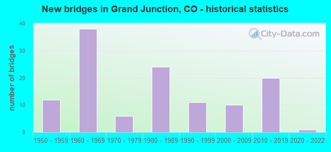
- New bridges - historical statistics
- 121950-1959
- 381960-1969
- 61970-1979
- 241980-1989
- 111990-1999
- 102000-2009
- 202010-2019
- 12020-2022
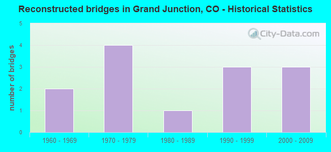
- Reconstructed bridges - Historical Statistics
- 21960-1969
- 41970-1979
- 11980-1989
- 31990-1999
- 32000-2009
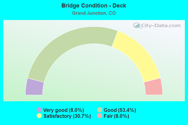
- Bridge Condition - Deck
- 8.0%Very good
- 53.4%Good
- 30.7%Satisfactory
- 8.0%Fair
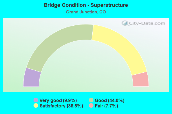
- Bridge Condition - Superstructure
- 9.9%Very good
- 44.0%Good
- 38.5%Satisfactory
- 7.7%Fair
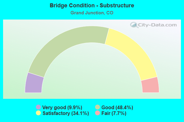
- Bridge Condition - Substructure
- 9.9%Very good
- 48.4%Good
- 34.1%Satisfactory
- 7.7%Fair
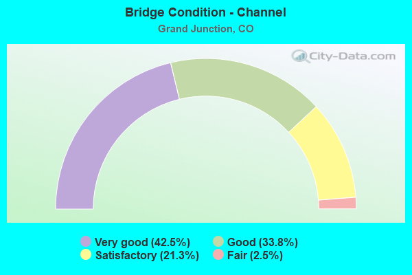
- Bridge Condition - Channel
- 42.5%Very good
- 33.8%Good
- 21.3%Satisfactory
- 2.5%Fair
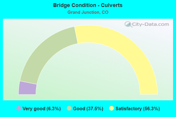
- Bridge Condition - Culverts
- 6.3%Very good
- 37.5%Good
- 56.3%Satisfactory
Find on map >> Show street view
Structure Number: H-03-Z, Location: 2.5 MI E OF GRAND JUNCTIO (Lat: 39.081592, Lng: -108.477933), Route carried "on" structure: Business State highway 70B, Year Built: 1956, Year Reconstructed: 1974, Status: Open, Structure Length: 2.05m (6.73ft), Average Daily Traffic: 14,000 (year 2020), Truck Traffic: 4%, Average Future Daily Traffic: 14,980 (year 2040), Design Load: HS 20, Features Intersected: LEWIS WASH, Facility Carried by Structure: I 70 BUSINESS RT
Minimum Vertical Clearance: 30+ m (98+ ft), Kilometerpoint: 16.969, Lanes on structure: 4, Base Highway Network: Yes, Owner: State Highway Agency, Approaching Roadway Width: 23.8m (78.1ft), Skew: 11 degrees, Material/Design: Concrete continuous, Design/Construction: Slab, Number Of Spans In Main Unit: 3, Length of Maximum Span: 6.4m (21.0ft), Curb-To-Curb Width: 29.9m (98.1ft), Out-to-Out Width: 30.9m (101.4ft)
Condition: Deck: Good, Superstructure: Good, Substructure: Satisfactory, Channel: Good, Operating Rating: 39.9 metric tons, Method Used To Determine Operating Rating: Load Factor (LF), Inventory Rating: 23.6 metric tons, Method Used To Determine Inventory Rating: Load Factor (LF), Structural Evaluation: Somewhat better than minimum adequacy, Deck Geometry: Superior to present desirable criteria, Waterway Adequacy: Equal to present desirable criteria, Approach Roadway Alignment: Equal to present desirable criteria, Designated Inspection Frequency: Every 24 months, Inspection Date: January 2021, Deck Structure Type: Concrete Cast-file-Place, Wearing Surface/Protective System: Wearing Surface: Bituminous
Find on map >> Show street view
Structure Number: MESA-21-H.4A, Location: 0.4 MI N of HWY 6 (Lat: 39.125278, Lng: -108.663889), Route carried "on" structure: County highway , Year Built: 2016, Status: Open, Structure Length: 0.90m (2.95ft), Average Daily Traffic: 1,362 (year 2018), Truck Traffic: 5%, Average Future Daily Traffic: 2,056 (year 2038), Design Load: HL 93, Features Intersected: INDP RANCHMENS DITCH, Facility Carried by Structure: COUNTY ROAD 21
Minimum Vertical Clearance: 30+ m (98+ ft), Kilometerpoint: 0.504, Lanes on structure: 2, Owner: County Highway Agency, Approaching Roadway Width: 6.7m (22.0ft), Skew: 6 degrees, Material/Design: Concrete, Design/Construction: Culvert, Number Of Spans In Main Unit: 1, Length of Maximum Span: 9.0m (29.5ft), Curb-To-Curb Width: 10.4m (34.1ft), Out-to-Out Width: 69.2m (227.0ft)
Condition: Channel: Satisfactory, Culverts: Very good, Operating Rating: 47.6 metric tons, Method Used To Determine Operating Rating: Load and Resistance Factor Rating (LRFR) rating reported by rating factor(RF) method using HL-93 loadings, Inventory Rating: 36.9 metric tons, Method Used To Determine Inventory Rating: Load and Resistance Factor Rating (LRFR) rating reported by rating factor(RF) method using HL-93 loadings, Structural Evaluation: Equal to present desirable criteria, Deck Geometry: Equal to present minimum criteria, Waterway Adequacy: Equal to present desirable criteria, Approach Roadway Alignment: Equal to present desirable criteria, Designated Inspection Frequency: Every 24 months, Inspection Date: March 2020
Find on map >> Show street view
Structure Number: MESA-21-K.5A, Location: .55 MI N OF RD K (Lat: 39.172722, Lng: -108.663889), Route carried "on" structure: County highway , Year Built: 1990, Status: Open, Structure Length: 0.92m (3.02ft), Average Daily Traffic: 465 (year 2018), Truck Traffic: 2%, Average Future Daily Traffic: 702 (year 2038), Design Load: HS 20, Features Intersected: GRAND VALLEY CANAL, Facility Carried by Structure: COUNTY ROAD 21
Minimum Vertical Clearance: 30+ m (98+ ft), Kilometerpoint: 4.796, Lanes on structure: 2, Owner: County Highway Agency, Approaching Roadway Width: 6.7m (22.0ft), Skew: 3 degrees, Material/Design: Steel, Design/Construction: Stringer/Multi-beam, Number Of Spans In Main Unit: 1, Length of Maximum Span: 8.0m (26.2ft), Curb-To-Curb Width: 8.9m (29.2ft), Out-to-Out Width: 9.1m (29.9ft)
Condition: Deck: Good, Superstructure: Satisfactory, Substructure: Satisfactory, Channel: Very good, Operating Rating: 47.2 metric tons, Method Used To Determine Operating Rating: Load Factor (LF), Inventory Rating: 28.3 metric tons, Method Used To Determine Inventory Rating: Load Factor (LF), Structural Evaluation: Equal to present minimum criteria, Deck Geometry: Somewhat better than minimum adequacy, Waterway Adequacy: Equal to present desirable criteria, Approach Roadway Alignment: Equal to present desirable criteria, Designated Inspection Frequency: Every 24 months, Inspection Date: January 2022, Deck Structure Type: Concrete Cast-file-Place, Wearing Surface/Protective System: Wearing Surface: Bituminous, Membrane: Built-up, Deck Protection: Other
Find on map >> Show street view
Structure Number: MESA-22-J.9-A, Location: 0.9 MILES N OF RD J (Lat: 39.162039, Lng: -108.645247), Route carried "on" structure: County highway , Year Built: 2020, Status: Open, Structure Length: 0.85m (2.79ft), Average Daily Traffic: 462 (year 2018), Truck Traffic: 2%, Average Future Daily Traffic: 697 (year 2038), Design Load: HS 20+Mod, Features Intersected: GRAND VALLEY CANAL, Facility Carried by Structure: COUNTY ROAD 22
Minimum Vertical Clearance: 30+ m (98+ ft), Kilometerpoint: 5.532, Lanes on structure: 2, Owner: County Highway Agency, Approaching Roadway Width: 9.9m (32.5ft), Material/Design: Concrete, Design/Construction: Culvert, Number Of Spans In Main Unit: 1, Length of Maximum Span: 8.5m (27.9ft), Curb-To-Curb Width: 23.9m (78.4ft), Out-to-Out Width: 24.5m (80.4ft)
Condition: Channel: Good, Culverts: Satisfactory, Operating Rating: 36.0 metric tons, Method Used To Determine Operating Rating: Load and Resistance Factor Rating (LRFR) rating reported by rating factor(RF) method using HL-93 loadings, Inventory Rating: 27.5 metric tons, Method Used To Determine Inventory Rating: Load and Resistance Factor Rating (LRFR) rating reported by rating factor(RF) method using HL-93 loadings, Structural Evaluation: Equal to present minimum criteria, Deck Geometry: Superior to present desirable criteria, Waterway Adequacy: Equal to present desirable criteria, Approach Roadway Alignment: Better than present minimum criteria, Designated Inspection Frequency: Every 24 months, Inspection Date: January 2022
Find on map >> Show street view
Structure Number: MESA-22-K.5A, Location: .5 MI N OF RD K (Lat: 39.169667, Lng: -108.645250), Route carried "on" structure: County highway , Year Built: 1983, Status: Posted for load, Structure Length: 0.73m (2.40ft), Average Daily Traffic: 275 (year 2018), Truck Traffic: 2%, Average Future Daily Traffic: 415 (year 2038), Features Intersected: HUNTER WASH, Facility Carried by Structure: COUNTY ROAD 22
Minimum Vertical Clearance: 30+ m (98+ ft), Kilometerpoint: 6.199, Lanes on structure: 2, Owner: County Highway Agency, Approaching Roadway Width: 6.7m (22.0ft), Material/Design: Steel, Design/Construction: Stringer/Multi-beam, Number Of Spans In Main Unit: 1, Length of Maximum Span: 6.9m (22.6ft), Curb-To-Curb Width: 9.7m (31.8ft), Out-to-Out Width: 9.8m (32.2ft)
Condition: Deck: Satisfactory, Superstructure: Satisfactory, Substructure: Satisfactory, Channel: Fair, Operating Rating: 30.6 metric tons, Method Used To Determine Operating Rating: Load Factor (LF), Inventory Rating: 18.3 metric tons, Method Used To Determine Inventory Rating: Load Factor (LF), Structural Evaluation: Somewhat better than minimum adequacy, Deck Geometry: Equal to present minimum criteria, Waterway Adequacy: Equal to present minimum criteria, Approach Roadway Alignment: Equal to present desirable criteria, Bridge Posting: Required (Relationship of Operating Rating to Maximum Legal Load: 0.1 - 9.9% below), Designated Inspection Frequency: Every 24 months, Inspection Date: January 2022, Deck Structure Type: Corrugated Steel, Wearing Surface/Protective System: Wearing Surface: Bituminous
Find on map >> Show street view
Structure Number: MESA-23-I.25, Location: .25 MI N OF RD I (Lat: 39.138806, Lng: -108.626472), Route carried "on" structure: County highway , Year Built: 1980, Status: Open, Structure Length: 0.83m (2.72ft), Average Daily Traffic: 2,287 (year 2018), Truck Traffic: 5%, Average Future Daily Traffic: 3,453 (year 2038), Design Load: HS 20, Features Intersected: PERSIGO WASH, Facility Carried by Structure: COUNTY ROAD 23
Minimum Vertical Clearance: 30+ m (98+ ft), Kilometerpoint: 1.994, Lanes on structure: 2, Owner: County Highway Agency, Approaching Roadway Width: 10.7m (35.1ft), Skew: 4 degrees, Material/Design: Aluminum, Iron, Design/Construction: Culvert, Number Of Spans In Main Unit: 1, Length of Maximum Span: 8.3m (27.2ft), Out-to-Out Width: 38.9m (127.6ft)
Condition: Channel: Good, Culverts: Good, Structural Evaluation: Better than present minimum criteria, Waterway Adequacy: Equal to present desirable criteria, Approach Roadway Alignment: Equal to present desirable criteria, Designated Inspection Frequency: Every 24 months, Inspection Date: January 2022
Find on map >> Show street view
Structure Number: MESA-23-I.9, Location: .9 MI N OF RD I (Lat: 39.147250, Lng: -108.626750), Route carried "on" structure: County highway , Year Built: 1955, Year Reconstructed: 1970, Status: Open, Structure Length: 0.81m (2.66ft), Average Daily Traffic: 1,626 (year 2018), Truck Traffic: 5%, Average Future Daily Traffic: 2,455 (year 2038), Features Intersected: GRAND VALLEY CANAL, Facility Carried by Structure: COUNTY ROAD 23
Minimum Vertical Clearance: 30+ m (98+ ft), Kilometerpoint: 2.963, Lanes on structure: 2, Owner: County Highway Agency, Approaching Roadway Width: 7.3m (24.0ft), Skew: 2 degrees, Material/Design: Concrete, Design/Construction: Tee Beam, Number Of Spans In Main Unit: 1, Length of Maximum Span: 7.2m (23.6ft), Curb-To-Curb Width: 9.8m (32.2ft), Out-to-Out Width: 10.0m (32.8ft)
Condition: Deck: Satisfactory, Superstructure: Satisfactory, Substructure: Satisfactory, Channel: Good, Operating Rating: 37.6 metric tons, Method Used To Determine Operating Rating: Load Factor (LF), Inventory Rating: 22.5 metric tons, Method Used To Determine Inventory Rating: Load Factor (LF), Structural Evaluation: Equal to present minimum criteria, Deck Geometry: Somewhat better than minimum adequacy, Waterway Adequacy: Equal to present desirable criteria, Approach Roadway Alignment: Equal to present desirable criteria, Designated Inspection Frequency: Every 24 months, Inspection Date: January 2022, Deck Structure Type: Other, Wearing Surface/Protective System: Wearing Surface: Bituminous
Find on map >> Show street view
Structure Number: MESA-23.5-I.4A, Location: .4 MI N OF RD I (Lat: 39.140611, Lng: -108.617389), Route carried "on" structure: County highway , Year Built: 1992, Status: Open, Structure Length: 0.79m (2.59ft), Average Daily Traffic: 37 (year 2018), Average Future Daily Traffic: 56 (year 2038), Features Intersected: GRAND VALLEY CANAL, Facility Carried by Structure: COUNTY ROAD 23.5
Minimum Vertical Clearance: 30+ m (98+ ft), Kilometerpoint: 0.593, Lanes on structure: 2, Owner: County Highway Agency, Approaching Roadway Width: 6.7m (22.0ft), Skew: 2 degrees, Material/Design: Steel, Design/Construction: Stringer/Multi-beam, Number Of Spans In Main Unit: 1, Length of Maximum Span: 6.9m (22.6ft), Curb-To-Curb Width: 7.1m (23.3ft), Out-to-Out Width: 7.3m (24.0ft)
Condition: Deck: Good, Superstructure: Satisfactory, Substructure: Good, Channel: Very good, Operating Rating: 70.3 metric tons, Method Used To Determine Operating Rating: Load Factor (LF), Inventory Rating: 42.1 metric tons, Method Used To Determine Inventory Rating: Load Factor (LF), Structural Evaluation: Equal to present minimum criteria, Deck Geometry: Somewhat better than minimum adequacy, Waterway Adequacy: Equal to present desirable criteria, Approach Roadway Alignment: Equal to present desirable criteria, Designated Inspection Frequency: Every 24 months, Inspection Date: January 2022, Deck Structure Type: Concrete Cast-file-Place, Wearing Surface/Protective System: Wearing Surface: Bituminous, Membrane: Built-up
Find on map >> Show street view
Structure Number: MESA-24-H.8, Location: .8 MI N OF RD H (Lat: 39.131750, Lng: -108.608083), Route carried "on" structure: County highway , Year Built: 1959, Year Reconstructed: 1990, Status: Open, Structure Length: 0.73m (2.40ft), Average Daily Traffic: 2,048 (year 2018), Truck Traffic: 5%, Average Future Daily Traffic: 3,093 (year 2038), Design Load: H 20, Features Intersected: GRAND VALLEY CANAL, Facility Carried by Structure: COUNTY ROAD 24
Minimum Vertical Clearance: 30+ m (98+ ft), Kilometerpoint: 1.196, Lanes on structure: 2, Owner: County Highway Agency, Approaching Roadway Width: 6.7m (22.0ft), Material/Design: Steel, Design/Construction: Stringer/Multi-beam, Number Of Spans In Main Unit: 1, Length of Maximum Span: 6.2m (20.3ft), Curb-To-Curb Width: 8.9m (29.2ft), Out-to-Out Width: 9.1m (29.9ft)
Condition: Deck: Fair, Superstructure: Fair, Substructure: Satisfactory, Channel: Good, Operating Rating: 45.4 metric tons, Method Used To Determine Operating Rating: Load Factor (LF), Inventory Rating: 27.1 metric tons, Method Used To Determine Inventory Rating: Load Factor (LF), Structural Evaluation: Somewhat better than minimum adequacy, Deck Geometry: Meets minimum limits, Waterway Adequacy: Equal to present desirable criteria, Approach Roadway Alignment: Equal to present desirable criteria, Designated Inspection Frequency: Every 24 months, Inspection Date: January 2022, Deck Structure Type: Corrugated Steel, Wearing Surface/Protective System: Wearing Surface: Bituminous
Find on map >> Show street view
Structure Number: MESA-24-H.96A, Location: AT INTERSECTION W/ RD I (Lat: 39.134861, Lng: -108.608083), Route carried "on" structure: County highway , Year Built: 2019, Status: Open, Structure Length: 1.34m (4.40ft), Average Daily Traffic: 1,860 (year 2018), Truck Traffic: 5%, Average Future Daily Traffic: 2,809 (year 2038), Features Intersected: GRAND VALLEY CANAL, Facility Carried by Structure: COUNTY ROAD 24
Minimum Vertical Clearance: 30+ m (98+ ft), Kilometerpoint: 1.591, Lanes on structure: 2, Owner: County Highway Agency, Approaching Roadway Width: 7.0m (23.0ft), Skew: 3 degrees, Material/Design: Prestressed concrete, Design/Construction: Slab, Number Of Spans In Main Unit: 1, Length of Maximum Span: 11.6m (38.1ft), Curb-To-Curb Width: 17.7m (58.1ft), Out-to-Out Width: 18.6m (61.0ft)
Condition: Deck: Very good, Superstructure: Very good, Substructure: Very good, Channel: Very good, Operating Rating: 64.5 metric tons, Method Used To Determine Operating Rating: Load and Resistance Factor Rating (LRFR) rating reported by rating factor(RF) method using HL-93 loadings, Inventory Rating: 49.6 metric tons, Method Used To Determine Inventory Rating: Load and Resistance Factor Rating (LRFR) rating reported by rating factor(RF) method using HL-93 loadings, Structural Evaluation: Equal to present desirable criteria, Deck Geometry: Superior to present desirable criteria, Waterway Adequacy: Equal to present desirable criteria, Approach Roadway Alignment: Equal to present desirable criteria, Designated Inspection Frequency: Every 24 months, Inspection Date: January 2022, Deck Structure Type: Concrete Cast-file-Place, Wearing Surface/Protective System: Wearing Surface: Bituminous
Find on map >> Show street view
Structure Number: MESA-24-I.05A, Location: .1 MI N OF RD I (Lat: 39.136556, Lng: -108.608056), Route carried "on" structure: County highway , Year Built: 2013, Status: Open, Structure Length: 1.70m (5.58ft), Average Daily Traffic: 2,231 (year 2018), Truck Traffic: 5%, Average Future Daily Traffic: 3,369 (year 2038), Features Intersected: GRAND VALLEY CANAL, Facility Carried by Structure: COUNTY ROAD 24
Minimum Vertical Clearance: 30+ m (98+ ft), Kilometerpoint: 1.763, Lanes on structure: 2, Owner: County Highway Agency, Approaching Roadway Width: 6.7m (22.0ft), Skew: 4 degrees, Material/Design: Prestressed concrete, Design/Construction: Slab, Number Of Spans In Main Unit: 1, Length of Maximum Span: 14.9m (48.9ft), Curb-To-Curb Width: 17.7m (58.1ft), Out-to-Out Width: 21.1m (69.2ft)
Condition: Deck: Very good, Superstructure: Good, Substructure: Very good, Channel: Good, Operating Rating: 47.6 metric tons, Method Used To Determine Operating Rating: Load and Resistance Factor Rating (LRFR) rating reported by rating factor(RF) method using HL-93 loadings, Inventory Rating: 36.6 metric tons, Method Used To Determine Inventory Rating: Load and Resistance Factor Rating (LRFR) rating reported by rating factor(RF) method using HL-93 loadings, Structural Evaluation: Better than present minimum criteria, Deck Geometry: Superior to present desirable criteria, Waterway Adequacy: Equal to present desirable criteria, Approach Roadway Alignment: Equal to present desirable criteria, Designated Inspection Frequency: Every 24 months, Inspection Date: January 2022, Deck Structure Type: Concrete Cast-file-Place, Wearing Surface/Protective System: Wearing Surface: Bituminous, Deck Protection: Epoxy Coated Reinforcing
Find on map >> Show street view
Structure Number: MESA-24-I.3A, Location: .3 MI N OF RD I (Lat: 39.139278, Lng: -108.608111), Route carried "on" structure: County highway , Year Built: 2013, Status: Open, Structure Length: 1.80m (5.91ft), Average Daily Traffic: 2,168 (year 2018), Truck Traffic: 5%, Average Future Daily Traffic: 3,274 (year 2038), Features Intersected: GRAND VALLEY CANAL, Facility Carried by Structure: COUNTY ROAD 24
Minimum Vertical Clearance: 30+ m (98+ ft), Kilometerpoint: 2.063, Lanes on structure: 2, Owner: County Highway Agency, Approaching Roadway Width: 6.7m (22.0ft), Skew: 4 degrees, Material/Design: Prestressed concrete, Design/Construction: Slab, Number Of Spans In Main Unit: 1, Length of Maximum Span: 15.2m (49.9ft), Curb-To-Curb Width: 17.4m (57.1ft), Out-to-Out Width: 20.5m (67.3ft)
Condition: Deck: Very good, Superstructure: Very good, Substructure: Very good, Channel: Very good, Operating Rating: 36.6 metric tons, Method Used To Determine Operating Rating: Load and Resistance Factor Rating (LRFR) rating reported by rating factor(RF) method using HL-93 loadings, Inventory Rating: 28.2 metric tons, Method Used To Determine Inventory Rating: Load and Resistance Factor Rating (LRFR) rating reported by rating factor(RF) method using HL-93 loadings, Structural Evaluation: Better than present minimum criteria, Deck Geometry: Superior to present desirable criteria, Waterway Adequacy: Equal to present desirable criteria, Approach Roadway Alignment: Better than present minimum criteria, Designated Inspection Frequency: Every 24 months, Inspection Date: January 2022, Deck Structure Type: Concrete Cast-file-Place, Wearing Surface/Protective System: Wearing Surface: Bituminous, Deck Protection: Epoxy Coated Reinforcing
Find on map >> Show street view
Structure Number: MESA-24-I.4A, Location: .4 MI N OF RD I (Lat: 39.141028, Lng: -108.608056), Route carried "on" structure: County highway , Year Built: 2013, Status: Open, Structure Length: 1.10m (3.61ft), Average Daily Traffic: 2,171 (year 2018), Truck Traffic: 5%, Average Future Daily Traffic: 3,279 (year 2038), Features Intersected: GRAND VALLEY CANAL, Facility Carried by Structure: COUNTY ROAD 24
Minimum Vertical Clearance: 30+ m (98+ ft), Kilometerpoint: 2.256, Lanes on structure: 2, Owner: County Highway Agency, Approaching Roadway Width: 6.7m (22.0ft), Skew: 2 degrees, Material/Design: Prestressed concrete, Design/Construction: Slab, Number Of Spans In Main Unit: 1, Length of Maximum Span: 9.3m (30.5ft), Curb-To-Curb Width: 17.5m (57.4ft), Out-to-Out Width: 26.8m (87.9ft)
Condition: Deck: Very good, Superstructure: Very good, Substructure: Very good, Channel: Good, Operating Rating: 75.2 metric tons, Method Used To Determine Operating Rating: Load and Resistance Factor Rating (LRFR) rating reported by rating factor(RF) method using HL-93 loadings, Inventory Rating: 58.0 metric tons, Method Used To Determine Inventory Rating: Load and Resistance Factor Rating (LRFR) rating reported by rating factor(RF) method using HL-93 loadings, Structural Evaluation: Equal to present desirable criteria, Deck Geometry: Superior to present desirable criteria, Waterway Adequacy: Equal to present desirable criteria, Approach Roadway Alignment: Better than present minimum criteria, Designated Inspection Frequency: Every 24 months, Inspection Date: January 2022, Deck Structure Type: Concrete Cast-file-Place, Wearing Surface/Protective System: Wearing Surface: Bituminous, Deck Protection: Epoxy Coated Reinforcing
Find on map >> Show street view
Structure Number: MESA-24-J.6, Location: 0.6 MI NORTH OF RD J (Lat: 39.157028, Lng: -108.608083), Route carried "on" structure: County highway , Year Built: 2010, Status: Open, Structure Length: 0.98m (3.22ft), Average Daily Traffic: 1,369 (year 2018), Truck Traffic: 10%, Average Future Daily Traffic: 2,067 (year 2038), Design Load: HS 20, Features Intersected: PERSIGO WASH, Facility Carried by Structure: COUNTY ROAD 24
Minimum Vertical Clearance: 30+ m (98+ ft), Kilometerpoint: 4.022, Lanes on structure: 2, Owner: County Highway Agency, Approaching Roadway Width: 6.7m (22.0ft), Skew: 1 degrees, Material/Design: Prestressed concrete, Design/Construction: Slab, Number Of Spans In Main Unit: 1, Length of Maximum Span: 8.6m (28.2ft), Curb-To-Curb Width: 9.6m (31.5ft), Out-to-Out Width: 11.1m (36.4ft)
Condition: Deck: Good, Superstructure: Good, Substructure: Good, Channel: Good, Operating Rating: 65.1 metric tons, Method Used To Determine Operating Rating: Load Factor (LF), Inventory Rating: 39.0 metric tons, Method Used To Determine Inventory Rating: Load Factor (LF), Structural Evaluation: Better than present minimum criteria, Deck Geometry: Somewhat better than minimum adequacy, Waterway Adequacy: Equal to present desirable criteria, Approach Roadway Alignment: Equal to present desirable criteria, Designated Inspection Frequency: Every 24 months, Inspection Date: January 2022, Deck Structure Type: Other, Wearing Surface/Protective System: Wearing Surface: Bituminous, Membrane: Built-up
Find on map >> Show street view
Structure Number: MESA-24.5-H.5A, Location: .5 MI N OF RD H (Lat: 39.128944, Lng: -108.598778), Route carried "on" structure: County highway , Year Built: 1987, Status: Open, Structure Length: 0.92m (3.02ft), Average Daily Traffic: 372 (year 2018), Truck Traffic: 2%, Average Future Daily Traffic: 562 (year 2038), Design Load: HS 20, Features Intersected: GRAND VALLEY CANAL, Facility Carried by Structure: COUNTY ROAD 24.5
Minimum Vertical Clearance: 30+ m (98+ ft), Kilometerpoint: 1.743, Lanes on structure: 2, Owner: County Highway Agency, Approaching Roadway Width: 7.6m (24.9ft), Skew: 1 degrees, Material/Design: Steel, Design/Construction: Stringer/Multi-beam, Number Of Spans In Main Unit: 1, Length of Maximum Span: 8.7m (28.5ft), Curb-To-Curb Width: 9.4m (30.8ft), Out-to-Out Width: 10.0m (32.8ft)
Condition: Deck: Fair, Superstructure: Satisfactory, Substructure: Satisfactory, Channel: Good, Operating Rating: 30.1 metric tons, Method Used To Determine Operating Rating: Load Factor (LF), Inventory Rating: 18.1 metric tons, Method Used To Determine Inventory Rating: Load Factor (LF), Structural Evaluation: Somewhat better than minimum adequacy, Deck Geometry: Equal to present minimum criteria, Waterway Adequacy: Equal to present desirable criteria, Approach Roadway Alignment: Equal to present desirable criteria, Designated Inspection Frequency: Every 24 months, Inspection Date: January 2022, Deck Structure Type: Corrugated Steel, Wearing Surface/Protective System: Wearing Surface: Bituminous
Find on map >> Show street view
Structure Number: MESA-25-H.3A, Location: .3 MI N OF RD H (Lat: 39.124581, Lng: -108.589586), Route carried "on" structure: County highway , Year Built: 1983, Status: Open, Structure Length: 0.91m (2.99ft), Average Daily Traffic: 1,181 (year 2018), Truck Traffic: 5%, Average Future Daily Traffic: 1,784 (year 2038), Features Intersected: GRAND VALLEY CANAL, Facility Carried by Structure: COUNTY ROAD 25
Minimum Vertical Clearance: 30+ m (98+ ft), Kilometerpoint: 1.477, Lanes on structure: 2, Owner: County Highway Agency, Approaching Roadway Width: 7.0m (23.0ft), Material/Design: Prestressed concrete, Design/Construction: Tee Beam, Number Of Spans In Main Unit: 1, Length of Maximum Span: 8.7m (28.5ft), Curb or Sidewalk Widths: Left: 0.1m (0.3ft), Right: 0.1m (0.3ft), Curb-To-Curb Width: 8.7m (28.5ft), Out-to-Out Width: 9.1m (29.9ft)
Condition: Deck: Satisfactory, Superstructure: Satisfactory, Substructure: Satisfactory, Channel: Good, Operating Rating: 36.3 metric tons, Method Used To Determine Operating Rating: Field evaluation and documented engineering judgment, Inventory Rating: 32.7 metric tons, Method Used To Determine Inventory Rating: Field evaluation and documented engineering judgment, Structural Evaluation: Equal to present minimum criteria, Deck Geometry: Somewhat better than minimum adequacy, Waterway Adequacy: Equal to present desirable criteria, Approach Roadway Alignment: Equal to present desirable criteria, Designated Inspection Frequency: Every 24 months, Inspection Date: January 2022, Deck Structure Type: Other, Wearing Surface/Protective System: Wearing Surface: Bituminous
Find on map >> Show street view
Structure Number: MESA-25-J.00A, Location: .3 MI N OF RD 25 & J (Lat: 39.149917, Lng: -108.586611), Route carried "on" structure: County highway , Year Built: 1987, Status: Open, Structure Length: 1.68m (5.51ft), Average Daily Traffic: 168 (year 2018), Truck Traffic: 2%, Average Future Daily Traffic: 254 (year 2038), Design Load: HS 20, Features Intersected: GOVT. HIGHLINE CANAL, Facility Carried by Structure: COUNTY ROAD 25
Minimum Vertical Clearance: 30+ m (98+ ft), Kilometerpoint: 4.535, Lanes on structure: 1, Owner: County Highway Agency, Approaching Roadway Width: 6.4m (21.0ft), Material/Design: Steel, Design/Construction: Stringer/Multi-beam, Number Of Spans In Main Unit: 1, Length of Maximum Span: 16.3m (53.5ft), Curb-To-Curb Width: 4.7m (15.4ft), Out-to-Out Width: 5.0m (16.4ft)
Condition: Deck: Satisfactory, Superstructure: Satisfactory, Substructure: Satisfactory, Channel: Very good, Operating Rating: 70.1 metric tons, Method Used To Determine Operating Rating: Load Factor (LF), Inventory Rating: 42.0 metric tons, Method Used To Determine Inventory Rating: Load Factor (LF), Structural Evaluation: Equal to present minimum criteria, Deck Geometry: High priority of replacement, Waterway Adequacy: Equal to present desirable criteria, Approach Roadway Alignment: Somewhat better than minimum adequacy, Length Of Structure Improvement: 1.68m (5.51ft), Designated Inspection Frequency: Every 24 months, Inspection Date: January 2022, Bridge Improvement Cost: $228,000, Roadway Improvement Cost: $23,000, Total Project Cost: $251,000 ( Estimate for 2020), Deck Structure Type: Corrugated Steel, Wearing Surface/Protective System: Wearing Surface: Bituminous
Find on map >> Show street view
Structure Number: MESA-29.5-E.63A, Location: .63Mi N of US6 (Lat: 39.086014, Lng: -108.515089), Route carried "on" structure: County highway , Year Built: 2017, Status: Open, Structure Length: 1.30m (4.27ft), Average Daily Traffic: 4,429 (year 2018), Truck Traffic: 5%, Average Future Daily Traffic: 6,687 (year 2038), Design Load: HL 93, Features Intersected: Grand Valley Canal, Facility Carried by Structure: Co Rd 29.5
Minimum Vertical Clearance: 30+ m (98+ ft), Kilometerpoint: 0.993, Lanes on structure: 2, Owner: County Highway Agency, Approaching Roadway Width: 13.4m (44.0ft), Material/Design: Prestressed concrete, Design/Construction: Slab, Number Of Spans In Main Unit: 1, Length of Maximum Span: 11.4m (37.4ft), Curb or Sidewalk Widths: Left: 1.7m (5.6ft), Right: 1.7m (5.6ft), Curb-To-Curb Width: 14.3m (46.9ft), Out-to-Out Width: 18.5m (60.7ft)
Condition: Deck: Good, Superstructure: Good, Substructure: Very good, Channel: Good, Operating Rating: 77.8 metric tons, Method Used To Determine Operating Rating: Load and Resistance Factor Rating (LRFR) rating reported by rating factor(RF) method using HL-93 loadings, Inventory Rating: 59.9 metric tons, Method Used To Determine Inventory Rating: Load and Resistance Factor Rating (LRFR) rating reported by rating factor(RF) method using HL-93 loadings, Structural Evaluation: Better than present minimum criteria, Deck Geometry: Superior to present desirable criteria, Waterway Adequacy: Equal to present desirable criteria, Approach Roadway Alignment: Equal to present desirable criteria, Designated Inspection Frequency: Every 24 months, Inspection Date: Febuary 2020, Deck Structure Type: Concrete Cast-file-Place, Wearing Surface/Protective System: Wearing Surface: Epoxy Overlay, Deck Protection: Epoxy Coated Reinforcing
Find on map >> Show street view
Structure Number: MESA-G.5-25.6A, Location: .6 MI E OF RD 25 (Lat: 39.113583, Lng: -108.578167), Route carried "on" structure: County highway , Year Built: 1984, Status: Open, Structure Length: 0.79m (2.59ft), Average Daily Traffic: 809 (year 2018), Truck Traffic: 2%, Average Future Daily Traffic: 1,222 (year 2038), Features Intersected: GRAND VALLEY CANAL, Facility Carried by Structure: COUNTY ROAD G.5
Minimum Vertical Clearance: 30+ m (98+ ft), Kilometerpoint: 1.035, Lanes on structure: 2, Owner: County Highway Agency, Approaching Roadway Width: 6.7m (22.0ft), Skew: 2 degrees, Material/Design: Steel, Design/Construction: Stringer/Multi-beam, Number Of Spans In Main Unit: 1, Length of Maximum Span: 7.4m (24.3ft), Curb-To-Curb Width: 9.7m (31.8ft), Out-to-Out Width: 10.2m (33.5ft)
Condition: Deck: Fair, Superstructure: Fair, Substructure: Fair, Channel: Very good, Operating Rating: 33.5 metric tons, Method Used To Determine Operating Rating: Load Factor (LF), Inventory Rating: 20.0 metric tons, Method Used To Determine Inventory Rating: Load Factor (LF), Structural Evaluation: Somewhat better than minimum adequacy, Deck Geometry: Equal to present minimum criteria, Waterway Adequacy: Equal to present desirable criteria, Approach Roadway Alignment: Better than present minimum criteria, Designated Inspection Frequency: Every 24 months, Inspection Date: Febuary 2022, Deck Structure Type: Corrugated Steel, Wearing Surface/Protective System: Wearing Surface: Bituminous
Find on map >> Show street view
Structure Number: MESA-H-24.1, Location: .1 MI E OF RD 24 (Lat: 39.120806, Lng: -108.606333), Route carried "on" structure: County highway , Year Built: 1962, Status: Open, Structure Length: 0.76m (2.49ft), Average Daily Traffic: 1,422 (year 2018), Truck Traffic: 5%, Average Future Daily Traffic: 2,147 (year 2038), Features Intersected: GRAND VALLEY CANAL, Facility Carried by Structure: COUNTY ROAD H
Minimum Vertical Clearance: 30+ m (98+ ft), Kilometerpoint: 0.690, Lanes on structure: 2, Owner: County Highway Agency, Approaching Roadway Width: 7.6m (24.9ft), Skew: 5 degrees, Material/Design: Concrete, Design/Construction: Slab, Number Of Spans In Main Unit: 1, Length of Maximum Span: 6.7m (22.0ft), Curb-To-Curb Width: 8.4m (27.6ft), Out-to-Out Width: 9.0m (29.5ft)
Condition: Deck: Satisfactory, Superstructure: Satisfactory, Substructure: Satisfactory, Channel: Very good, Operating Rating: 36.3 metric tons, Method Used To Determine Operating Rating: Field evaluation and documented engineering judgment, Inventory Rating: 32.7 metric tons, Method Used To Determine Inventory Rating: Field evaluation and documented engineering judgment, Structural Evaluation: Equal to present minimum criteria, Deck Geometry: Meets minimum limits, Waterway Adequacy: Equal to present desirable criteria, Approach Roadway Alignment: Equal to present desirable criteria, Designated Inspection Frequency: Every 24 months, Inspection Date: January 2022, Deck Structure Type: Concrete Cast-file-Place, Wearing Surface/Protective System: Wearing Surface: Bituminous
Find on map >> Show street view
Structure Number: MESA-I-24.1, Location: .1 MI E OF RD 24 (Lat: 39.135333, Lng: -108.607139), Route carried "on" structure: County highway , Year Built: 2001, Status: Open, Structure Length: 1.49m (4.89ft), Average Daily Traffic: 1,443 (year 2018), Truck Traffic: 5%, Average Future Daily Traffic: 2,179 (year 2038), Design Load: HS 20, Features Intersected: GRAND VALLEY CANAL, Facility Carried by Structure: COUNTY ROAD I
Minimum Vertical Clearance: 30+ m (98+ ft), Kilometerpoint: 1.690, Lanes on structure: 2, Owner: County Highway Agency, Approaching Roadway Width: 7.9m (25.9ft), Skew: 4 degrees, Material/Design: Prestressed concrete, Design/Construction: Box Beam or Girders - Single/Spread, Number Of Spans In Main Unit: 1, Length of Maximum Span: 13.4m (44.0ft), Curb-To-Curb Width: 12.3m (40.4ft), Out-to-Out Width: 13.3m (43.6ft)
Condition: Deck: Good, Superstructure: Good, Substructure: Good, Channel: Very good, Operating Rating: 71.8 metric tons, Method Used To Determine Operating Rating: Load Factor (LF), Inventory Rating: 42.9 metric tons, Method Used To Determine Inventory Rating: Load Factor (LF), Structural Evaluation: Better than present minimum criteria, Deck Geometry: Better than present minimum criteria, Waterway Adequacy: Equal to present desirable criteria, Approach Roadway Alignment: Equal to present desirable criteria, Designated Inspection Frequency: Every 24 months, Inspection Date: January 2022, Deck Structure Type: Other, Wearing Surface/Protective System: Wearing Surface: Bituminous, Deck Protection: Epoxy Coated Reinforcing
Find on map >> Show street view
Structure Number: MESA-J-20.8A, Location: .8 MI E OF RD 20 (Lat: 39.149833, Lng: -108.668583), Route carried "on" structure: County highway , Year Built: 1988, Status: Open, Structure Length: 4.02m (13.19ft), Average Daily Traffic: 843 (year 2018), Truck Traffic: 5%, Average Future Daily Traffic: 1,273 (year 2038), Design Load: HS 20, Features Intersected: HUNTER WASH, Facility Carried by Structure: COUNTY ROAD J
Minimum Vertical Clearance: 30+ m (98+ ft), Kilometerpoint: 4.802, Lanes on structure: 2, Owner: County Highway Agency, Approaching Roadway Width: 6.7m (22.0ft), Material/Design: Prestressed concrete, Design/Construction: Stringer/Multi-beam, Number Of Spans In Main Unit: 1, Length of Maximum Span: 38.6m (126.6ft), Curb-To-Curb Width: 8.6m (28.2ft), Out-to-Out Width: 9.3m (30.5ft)
Condition: Deck: Good, Superstructure: Very good, Substructure: Good, Channel: Satisfactory, Operating Rating: 67.6 metric tons, Method Used To Determine Operating Rating: Load Factor (LF), Inventory Rating: 25.6 metric tons, Method Used To Determine Inventory Rating: Load Factor (LF), Structural Evaluation: Equal to present minimum criteria, Deck Geometry: Somewhat better than minimum adequacy, Waterway Adequacy: Equal to present desirable criteria, Approach Roadway Alignment: Equal to present desirable criteria, Designated Inspection Frequency: Every 24 months, Inspection Date: January 2022, Deck Structure Type: Concrete Cast-file-Place, Wearing Surface/Protective System: Wearing Surface: Bituminous, Membrane: Built-up
Find on map >> Show street view
Structure Number: MESA-J-22.7, Location: .7 MI E OF RD 22 (Lat: 39.149806, Lng: -108.633278), Route carried "on" structure: County highway , Year Built: 1955, Year Reconstructed: 1970, Status: Open, Structure Length: 0.82m (2.69ft), Average Daily Traffic: 967 (year 2018), Truck Traffic: 2%, Average Future Daily Traffic: 1,461 (year 2038), Features Intersected: GRAND VALLEY CANAL, Facility Carried by Structure: COUNTY ROAD J
Minimum Vertical Clearance: 30+ m (98+ ft), Kilometerpoint: 7.862, Lanes on structure: 2, Owner: County Highway Agency, Approaching Roadway Width: 6.7m (22.0ft), Skew: 2 degrees, Material/Design: Concrete, Design/Construction: Tee Beam, Number Of Spans In Main Unit: 1, Length of Maximum Span: 7.6m (24.9ft), Curb-To-Curb Width: 10.0m (32.8ft), Out-to-Out Width: 10.1m (33.1ft)
Condition: Deck: Satisfactory, Superstructure: Fair, Substructure: Satisfactory, Channel: Satisfactory, Operating Rating: 36.3 metric tons, Method Used To Determine Operating Rating: Field evaluation and documented engineering judgment, Inventory Rating: 23.4 metric tons, Method Used To Determine Inventory Rating: Load Factor (LF), Structural Evaluation: Somewhat better than minimum adequacy, Deck Geometry: Equal to present minimum criteria, Waterway Adequacy: Equal to present desirable criteria, Approach Roadway Alignment: Equal to present desirable criteria, Designated Inspection Frequency: Every 24 months, Inspection Date: January 2022, Deck Structure Type: Other, Wearing Surface/Protective System: Wearing Surface: Bituminous
Find on map >> Show street view
Structure Number: MESA-J-23.1A, Location: .1 MI E OF RD 23 (Lat: 39.149806, Lng: -108.625194), Route carried "on" structure: County highway , Year Built: 1985, Status: Open, Structure Length: 0.71m (2.33ft), Average Daily Traffic: 500 (year 2018), Truck Traffic: 2%, Average Future Daily Traffic: 755 (year 2038), Features Intersected: GRAND VALLEY CANAL, Facility Carried by Structure: COUNTY ROAD J
Minimum Vertical Clearance: 30+ m (98+ ft), Kilometerpoint: 8.552, Lanes on structure: 2, Owner: County Highway Agency, Approaching Roadway Width: 7.0m (23.0ft), Skew: 1 degrees, Material/Design: Steel, Design/Construction: Stringer/Multi-beam, Number Of Spans In Main Unit: 1, Length of Maximum Span: 6.6m (21.7ft), Curb-To-Curb Width: 7.8m (25.6ft), Out-to-Out Width: 8.0m (26.2ft)
Condition: Deck: Satisfactory, Superstructure: Fair, Substructure: Fair, Channel: Good, Operating Rating: 41.8 metric tons, Method Used To Determine Operating Rating: Load Factor (LF), Inventory Rating: 25.0 metric tons, Method Used To Determine Inventory Rating: Load Factor (LF), Structural Evaluation: Somewhat better than minimum adequacy, Deck Geometry: Meets minimum limits, Waterway Adequacy: Equal to present desirable criteria, Approach Roadway Alignment: Better than present minimum criteria, Designated Inspection Frequency: Every 24 months, Inspection Date: January 2022, Deck Structure Type: Corrugated Steel, Wearing Surface/Protective System: Wearing Surface: Bituminous
Find on map >> Show street view
Structure Number: MESA-J-23.7, Location: .3 MI W OF RD 24 (Lat: 39.149806, Lng: -108.613917), Route carried "on" structure: County highway , Year Built: 1969, Year Reconstructed: 1991, Status: Open, Structure Length: 1.02m (3.35ft), Average Daily Traffic: 501 (year 2018), Truck Traffic: 2%, Average Future Daily Traffic: 757 (year 2038), Features Intersected: GRAND VALLEY CANAL, Facility Carried by Structure: COUNTY ROAD J
Minimum Vertical Clearance: 30+ m (98+ ft), Kilometerpoint: 9.531, Lanes on structure: 2, Owner: County Highway Agency, Approaching Roadway Width: 7.3m (24.0ft), Skew: 4 degrees, Material/Design: Steel, Design/Construction: Stringer/Multi-beam, Number Of Spans In Main Unit: 1, Length of Maximum Span: 9.4m (30.8ft), Curb or Sidewalk Widths: Left: 0.2m (0.7ft), Right: 0.2m (0.7ft), Curb-To-Curb Width: 8.0m (26.2ft), Out-to-Out Width: 8.5m (27.9ft)
Condition: Deck: Good, Superstructure: Satisfactory, Substructure: Satisfactory, Channel: Very good, Operating Rating: 61.0 metric tons, Method Used To Determine Operating Rating: Load Factor (LF), Inventory Rating: 36.5 metric tons, Method Used To Determine Inventory Rating: Load Factor (LF), Structural Evaluation: Equal to present minimum criteria, Deck Geometry: Somewhat better than minimum adequacy, Waterway Adequacy: Equal to present desirable criteria, Approach Roadway Alignment: Equal to present desirable criteria, Designated Inspection Frequency: Every 24 months, Inspection Date: January 2022, Deck Structure Type: Concrete Cast-file-Place, Wearing Surface/Protective System: Wearing Surface: Bituminous
Find on map >> Show street view
Structure Number: MESA-K-21.7A, Location: .7 MI E OF RD 21 (Lat: 39.164306, Lng: -108.651889), Route carried "on" structure: County highway , Year Built: 1992, Status: Open, Structure Length: 0.72m (2.36ft), Average Daily Traffic: 1,446 (year 2018), Truck Traffic: 5%, Average Future Daily Traffic: 2,183 (year 2038), Design Load: HS 20, Features Intersected: GRAND VALLEY CANAL, Facility Carried by Structure: COUNTY ROAD K
Minimum Vertical Clearance: 30+ m (98+ ft), Kilometerpoint: 4.918, Lanes on structure: 2, Owner: County Highway Agency, Approaching Roadway Width: 7.6m (24.9ft), Material/Design: Steel, Design/Construction: Stringer/Multi-beam, Number Of Spans In Main Unit: 1, Length of Maximum Span: 6.2m (20.3ft), Curb-To-Curb Width: 9.6m (31.5ft), Out-to-Out Width: 9.8m (32.2ft)
Condition: Deck: Good, Superstructure: Good, Substructure: Good, Channel: Very good, Operating Rating: 77.8 metric tons, Method Used To Determine Operating Rating: Load Factor (LF), Inventory Rating: 46.6 metric tons, Method Used To Determine Inventory Rating: Load Factor (LF), Structural Evaluation: Better than present minimum criteria, Deck Geometry: Somewhat better than minimum adequacy, Waterway Adequacy: Equal to present desirable criteria, Approach Roadway Alignment: Equal to present desirable criteria, Designated Inspection Frequency: Every 24 months, Inspection Date: January 2022, Deck Structure Type: Concrete Cast-file-Place, Wearing Surface/Protective System: Wearing Surface: Bituminous, Membrane: Built-up
Find on map >> Show street view
Structure Number: GRJ-23.95-E.96, Location: JCT I-70B and 24 RD (Lat: 39.090861, Lng: -108.609694), Route carried "under" structure: Business Interstate 70B, Year Built: 1984, Structure Length: 0. m, Average Daily Traffic: 27,000 (year 2012), Truck Traffic: 6%, Features Intersected: I-70B & UPPR RR, Facility Carried by Structure: REDLANDS PKY/24 RD
Minimum Vertical Clearance: 6.61m (21.69ft), Kilometerpoint: 2.513, Lanes on structure: 5, Lanes under structure: 5, Material/Design: Steel, Design/Construction: Stringer/Multi-beam, Length of Maximum Span: 30.4m (99.7ft)
Find on map >> Show street view
Structure Number: GRJ-29-D.65, Location: OVER I-70 BUSINESS RTE (Lat: 39.072361, Lng: -108.515222), Route carried "under" structure: Business US 70B, Year Built: 2010, Structure Length: 0. m, Average Daily Traffic: 20,000 (year 2010), Truck Traffic: 9%, Features Intersected: RR/I70 Business, Facility Carried by Structure: 29 Road
Minimum Vertical Clearance: 5.58m (18.31ft), Kilometerpoint: 8.900, Lanes on structure: 4, Lanes under structure: 7, Material/Design: Prestressed concrete continuous, Design/Construction: Stringer/Multi-beam, Length of Maximum Span: 46.7m (153.2ft)
Find on map >> Show street view
Structure Number: H-02-DS, Location: 3.3 MI E OF JCT US 6 ML (Lat: 39.113583, Lng: -108.589467), Route carried "under" structure: Interstate 70A, Year Built: 1965, Structure Length: 0. m, Average Daily Traffic: 24,000 (year 2018), Truck Traffic: 15%, Features Intersected: I 70 ML, Facility Carried by Structure: COUNTY ROAD 25
Minimum Vertical Clearance: 5.21m (17.09ft), Kilometerpoint: 0.169, Lanes on structure: 2, Lanes under structure: 4, Material/Design: Concrete continuous, Design/Construction: Tee Beam, Length of Maximum Span: 16.5m (54.1ft)
Find on map >> Show street view
Structure Number: H-02-EG, Location: 2.3 MI E OF JCT US 6 ML (Lat: 39.113703, Lng: -108.608217), Route carried "under" structure: Interstate 70A, Year Built: 2005, Structure Length: 0. m, Average Daily Traffic: 24,000 (year 2018), Truck Traffic: 16%, Features Intersected: I 70 ML, Facility Carried by Structure: COUNTY ROAD 24
Minimum Vertical Clearance: 5.59m (18.34ft), Kilometerpoint: 0.076, Lanes on structure: 3, Lanes under structure: 4, Material/Design: Prestressed concrete continuous, Design/Construction: Tee Beam, Length of Maximum Span: 26.2m (86.0ft)
Find on map >> Show street view
Structure Number: H-02-EM, Location: 1.27 MI W / HORIZON DRIVE (Lat: 39.115200, Lng: -108.561569), Route carried "under" structure: Interstate 70A, Year Built: 1965, Structure Length: 0. m, Average Daily Traffic: 3,400 (year 2014), Truck Traffic: 15%, Features Intersected: I 70 ML, Facility Carried by Structure: COUNTY ROAD 26.5
Minimum Vertical Clearance: 5.95m (19.52ft), Kilometerpoint: 2.073, Lanes on structure: 2, Lanes under structure: 4, Material/Design: Concrete continuous, Design/Construction: Tee Beam, Length of Maximum Span: 17.7m (58.1ft)
Find on map >> Show street view
Structure Number: H-02-EN, Location: 3.3 MI W / HORIZON DRIVE (Lat: 39.113642, Lng: -108.598767), Route carried "under" structure: Interstate 70A, Year Built: 1965, Structure Length: 0. m, Average Daily Traffic: 24,000 (year 2018), Truck Traffic: 15%, Features Intersected: I 70 ML, Facility Carried by Structure: COUNTY ROAD 24.5
Minimum Vertical Clearance: 5.69m (18.67ft), Kilometerpoint: 2.874, Lanes on structure: 2, Lanes under structure: 4, Material/Design: Concrete continuous, Design/Construction: Tee Beam, Length of Maximum Span: 16.5m (54.1ft)
Find on map >> Show street view
Structure Number: H-02-ET, Location: 0.8 MI W OF HORIZON DRIVE (Lat: 39.115439, Lng: -108.552278), Route carried "under" structure: Interstate 70A, Year Built: 1965, Structure Length: 0. m, Average Daily Traffic: 3,800 (year 2014), Truck Traffic: 15%, Features Intersected: I 70 ML, Facility Carried by Structure: COUNTY ROAD 27
Minimum Vertical Clearance: 5.41m (17.75ft), Kilometerpoint: 1.025, Lanes on structure: 2, Lanes under structure: 4, Material/Design: Concrete continuous, Design/Construction: Tee Beam, Length of Maximum Span: 16.5m (54.1ft)
Find on map >> Show street view
Structure Number: H-02-EZ, Location: 1.8 MI W OF HORIZON DRIVE (Lat: 39.114469, Lng: -108.570822), Route carried "under" structure: Interstate 70A, Year Built: 1965, Structure Length: 0. m, Average Daily Traffic: 3,100 (year 2014), Truck Traffic: 15%, Features Intersected: I 70 ML, Facility Carried by Structure: COUNTY ROAD 26
Minimum Vertical Clearance: 5.74m (18.83ft), Kilometerpoint: 0.190, Lanes on structure: 2, Lanes under structure: 4, Material/Design: Concrete continuous, Design/Construction: Tee Beam, Length of Maximum Span: 16.5m (54.1ft)
Find on map >> Show street view
Structure Number: H-02-FU, Location: 5.8 MI W OF HORIZON DRIVE (Lat: 39.112144, Lng: -108.644550), Route carried "under" structure: US 6A, Year Built: 1969, Structure Length: 0. m, Average Daily Traffic: 17,000 (year 2011), Truck Traffic: 4%, Features Intersected: US 6 ML, Facility Carried by Structure: I 70 ML WBND
Minimum Vertical Clearance: 6.00m (19.69ft), Kilometerpoint: 41.972, Lanes on structure: 2, Lanes under structure: 6, Material/Design: Steel continuous, Design/Construction: Stringer/Multi-beam, Length of Maximum Span: 26.8m (87.9ft)
Find on map >> Show street view
Structure Number: H-02-FW, Location: W END OF GRAND JUNCTION (Lat: 39.111992, Lng: -108.644425), Route carried "under" structure: US 6A, Year Built: 1969, Structure Length: 0. m, Average Daily Traffic: 19,000 (year 2018), Truck Traffic: 18%, Features Intersected: US 6 ML, Facility Carried by Structure: I 70 ML EBND
Minimum Vertical Clearance: 30+ m (98+ ft), Kilometerpoint: 41.165, Lanes on structure: 2, Lanes under structure: 2, Material/Design: Steel continuous, Design/Construction: Stringer/Multi-beam, Length of Maximum Span: 26.8m (87.9ft)
Find on map >> Show street view
Structure Number: H-02-GN, Location: S. SIDE OF GRAND JCT (Lat: 39.058428, Lng: -108.564897), Route carried "under" structure: US 50A, Year Built: 2010, Structure Length: 0. m, Average Daily Traffic: 21,000 (year 2011), Truck Traffic: 4%, Features Intersected: SH 50 ML, Facility Carried by Structure: RIVERSIDE PKWY
Minimum Vertical Clearance: 7.16m (23.49ft), Kilometerpoint: 2.639, Lanes on structure: 4, Lanes under structure: 4, Material/Design: Prestressed concrete continuous, Design/Construction: Tee Beam, Length of Maximum Span: 27.6m (90.6ft)
Find on map >> Show street view
Structure Number: H-02-J, Location: IN GRAND JUNCTION (Lat: 39.077561, Lng: -108.577169), Route carried "under" structure: US 6B, Year Built: 1957, Structure Length: 0. m, Average Daily Traffic: 18,000 (year 2011), Truck Traffic: 3%, Features Intersected: US 6 EBND, Facility Carried by Structure: I70 BUS. RT WBND
Minimum Vertical Clearance: 5.05m (16.57ft), Kilometerpoint: 48.715, Lanes on structure: 2, Lanes under structure: 2, Material/Design: Steel continuous, Design/Construction: Stringer/Multi-beam, Length of Maximum Span: 18.6m (61.0ft)
Find on map >> Show street view
Structure Number: H-02-O, Location: 3.5 MI W / GJ I-70 BUS RT (Lat: 39.107911, Lng: -108.511075), Route carried "under" structure: Interstate 70A, Year Built: 1964, Structure Length: 0. m, Average Daily Traffic: 23,000 (year 2018), Truck Traffic: 13%, Features Intersected: I 70 ML, Facility Carried by Structure: COUNTY ROAD 29
Minimum Vertical Clearance: 5.74m (18.83ft), Kilometerpoint: 2.383, Lanes on structure: 2, Lanes under structure: 4, Material/Design: Concrete continuous, Design/Construction: Tee Beam, Length of Maximum Span: 19.9m (65.3ft)
Find on map >> Show street view
Structure Number: H-02-Q, Location: 1.3 MI E OF JCT US 6 ML (Lat: 39.113728, Lng: -108.626625), Route carried "under" structure: Interstate 70A, Year Built: 1965, Structure Length: 0. m, Average Daily Traffic: 18,000 (year 2018), Truck Traffic: 16%, Features Intersected: I 70 ML, Facility Carried by Structure: COUNTY ROAD 23
Minimum Vertical Clearance: 5.56m (18.24ft), Kilometerpoint: 0.003, Lanes on structure: 2, Lanes under structure: 4, Material/Design: Concrete continuous, Design/Construction: Tee Beam, Length of Maximum Span: 16.5m (54.1ft)
Find on map >> Show street view
Structure Number: H-02-T, Location: 2.4 MI. E. OF I-70 WBND B (Lat: 39.040453, Lng: -108.545575), Route carried "under" structure: US 50A, Year Built: 1959, Structure Length: 0. m, Average Daily Traffic: 18,000 (year 2018), Truck Traffic: 6%, Features Intersected: US 50 ML, Facility Carried by Structure: COUNTY ROAD
Minimum Vertical Clearance: 5.69m (18.67ft), Kilometerpoint: 0.167, Lanes on structure: 1, Lanes under structure: 4, Material/Design: Concrete continuous, Design/Construction: Tee Beam, Length of Maximum Span: 19.2m (63.0ft)