Bridge Statistics for Grandview, Missouri (MO)
Condition, Traffic, Stress, Structural Evaluation, Project Costs
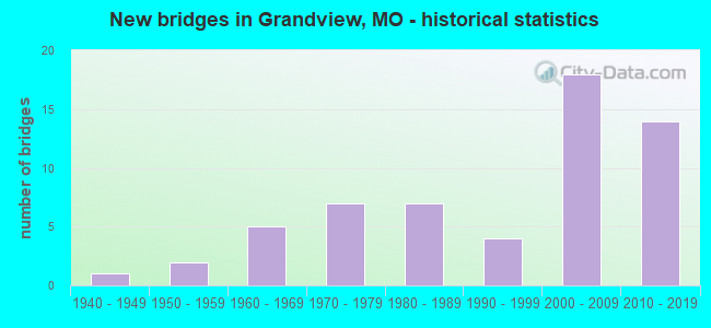
- New bridges - historical statistics
- 11940-1949
- 21950-1959
- 51960-1969
- 71970-1979
- 71980-1989
- 41990-1999
- 182000-2009
- 142010-2019

- Reconstructed bridges - Historical Statistics
- 11970-1979
- 31980-1989
- 01990-1999
- 32000-2009
- 12010-2019


- Bridge Condition - Deck
- 12.5%Very good
- 40.6%Good
- 46.9%Satisfactory

- Bridge Condition - Superstructure
- 18.8%Excellent
- 6.3%Very good
- 43.8%Good
- 28.1%Satisfactory
- 3.1%Fair

- Bridge Condition - Substructure
- 21.9%Excellent
- 15.6%Very good
- 21.9%Good
- 34.4%Satisfactory
- 6.3%Fair

- Bridge Condition - Channel
- 4.3%Very good
- 34.8%Good
- 34.8%Satisfactory
- 26.1%Fair

- Bridge Condition - Culverts
- 25.0%Good
- 50.0%Satisfactory
- 25.0%Fair
Find on map >> Show street view
Structure Number: 32207, Location: S 25 T 47 N R 33 W (Lat: 38.857928, Lng: -94.527267), Route carried "under" structure: State highway 150, Year Built: 2008, Structure Length: 0. m, Average Daily Traffic: 7,778 (year 2021), Truck Traffic: 7%, Features Intersected: MO 150, Facility Carried by Structure: OR 49 N
Minimum Vertical Clearance: 5.54m (18.18ft), Kilometerpoint: 32.535, Lanes on structure: 2, Lanes under structure: 5, Material/Design: Prestressed concrete continuous, Design/Construction: Tee Beam, Length of Maximum Span: 32.6m (107.0ft)
Find on map >> Show street view
Structure Number: 33162, Location: S 35 T 47 N R 33 W (Lat: 38.858631, Lng: -94.546717), Route carried "under" structure: State highway 150, Year Built: 2010, Structure Length: 0. m, Average Daily Traffic: 9,934 (year 2021), Truck Traffic: 3%, Features Intersected: MO 150, Facility Carried by Structure: BOTTS RD S
Minimum Vertical Clearance: 5.18m (16.99ft), Kilometerpoint: 34.220, Lanes on structure: 6, Lanes under structure: 2, Material/Design: Prestressed concrete, Design/Construction: Stringer/Multi-beam, Length of Maximum Span: 20.8m (68.2ft)
Find on map >> Show street view
Structure Number: 33162, Location: S 35 T 47 N R 33 W (Lat: 38.858631, Lng: -94.546717), Route carried "under" structure: State highway 150, Year Built: 2010, Structure Length: 0. m, Average Daily Traffic: 11,261 (year 2021), Truck Traffic: 5%, Features Intersected: MO 150, Facility Carried by Structure: BOTTS RD S
Minimum Vertical Clearance: 5.41m (17.75ft), Kilometerpoint: 7.075, Lanes on structure: 6, Lanes under structure: 2, Material/Design: Prestressed concrete, Design/Construction: Stringer/Multi-beam, Length of Maximum Span: 20.8m (68.2ft)
Find on map >> Show street view
Structure Number: 33987, Location: S 35 T 47 N R 33 W (Lat: 38.858883, Lng: -94.551939), Route carried "under" structure: State highway 150, Year Built: 2012, Structure Length: 0. m, Average Daily Traffic: 9,934 (year 2021), Truck Traffic: 3%, Features Intersected: MO 150
Minimum Vertical Clearance: 5.05m (16.57ft), Kilometerpoint: 35.291, Lanes on structure: 1, Lanes under structure: 2, Material/Design: Prestressed concrete, Design/Construction: Stringer/Multi-beam, Length of Maximum Span: 21.3m (69.9ft)
Find on map >> Show street view
Structure Number: 33987, Location: S 35 T 47 N R 33 W (Lat: 38.858883, Lng: -94.551939), Route carried "under" structure: State highway 150, Year Built: 2012, Structure Length: 0. m, Average Daily Traffic: 11,261 (year 2021), Truck Traffic: 5%, Features Intersected: MO 150
Minimum Vertical Clearance: 5.08m (16.67ft), Kilometerpoint: 6.003, Lanes on structure: 1, Lanes under structure: 2, Material/Design: Prestressed concrete, Design/Construction: Stringer/Multi-beam, Length of Maximum Span: 21.3m (69.9ft)
Find on map >> Show street view
Structure Number: 35265, Location: S 14 T 47 N R 33 W (Lat: 38.888892, Lng: -94.525158), Route carried "under" structure: Interstate 49, Year Built: 2016, Structure Length: 0. m, Average Daily Traffic: 41,668 (year 2021), Truck Traffic: 17%, Features Intersected: IS 49, Facility Carried by Structure: MAIN ST E
Minimum Vertical Clearance: 5.08m (16.67ft), Kilometerpoint: 289.982, Lanes on structure: 5, Lanes under structure: 3, Material/Design: Prestressed concrete continuous, Design/Construction: Tee Beam, Length of Maximum Span: 28.6m (93.8ft)
Find on map >> Show street view
Structure Number: 35265, Location: S 14 T 47 N R 33 W (Lat: 38.888892, Lng: -94.525158), Route carried "under" structure: Interstate 49, Year Built: 2016, Structure Length: 0. m, Average Daily Traffic: 54,526 (year 2021), Truck Traffic: 12%, Features Intersected: IS 49, Facility Carried by Structure: MAIN ST E
Minimum Vertical Clearance: 5.09m (16.70ft), Kilometerpoint: 6.088, Lanes on structure: 5, Lanes under structure: 3, Material/Design: Prestressed concrete continuous, Design/Construction: Tee Beam, Length of Maximum Span: 28.6m (93.8ft)
Find on map >> Show street view
Structure Number: 35395, Location: S 35 T 47 N R 33 W (Lat: 38.843647, Lng: -94.529444), Route carried "under" structure: Interstate 49, Year Built: 2017, Structure Length: 0. m, Average Daily Traffic: 35,708 (year 2021), Truck Traffic: 17%, Features Intersected: IS 49, Facility Carried by Structure: 155TH ST E
Minimum Vertical Clearance: 5.03m (16.50ft), Kilometerpoint: 284.953, Lanes on structure: 3, Lanes under structure: 3, Material/Design: Prestressed concrete, Design/Construction: Box Beam or Girders - Single/Spread, Length of Maximum Span: 23.8m (78.1ft)
Find on map >> Show street view
Structure Number: 35395, Location: S 35 T 47 N R 33 W (Lat: 38.843647, Lng: -94.529444), Route carried "under" structure: Interstate 49, Year Built: 2017, Structure Length: 0. m, Average Daily Traffic: 49,628 (year 2021), Truck Traffic: 12%, Features Intersected: IS 49, Facility Carried by Structure: 155TH ST E
Minimum Vertical Clearance: 5.18m (16.99ft), Kilometerpoint: 11.116, Lanes on structure: 3, Lanes under structure: 3, Material/Design: Prestressed concrete, Design/Construction: Box Beam or Girders - Single/Spread, Length of Maximum Span: 23.8m (78.1ft)
Find on map >> Show street view
Structure Number: 66, Location: S 12 T 47 N R 33 W (Lat: 38.908203, Lng: -94.523778), Route carried "under" structure: Interstate 49, Year Built: 1960, Structure Length: 0. m, Average Daily Traffic: 48,000 (year 2021), Truck Traffic: 10%, Features Intersected: IS 49, Facility Carried by Structure: BLUE RIDGE BLVD S
Minimum Vertical Clearance: 5.28m (17.32ft), Kilometerpoint: 3.953, Lanes on structure: 6, Lanes under structure: 3, Material/Design: Steel continuous, Design/Construction: Stringer/Multi-beam, Length of Maximum Span: 24.1m (79.1ft)
Find on map >> Show street view
Structure Number: 66, Location: S 12 T 47 N R 33 W (Lat: 38.908203, Lng: -94.523778), Route carried "under" structure: Interstate 49, Year Built: 1960, Structure Length: 0. m, Average Daily Traffic: 47,288 (year 2021), Truck Traffic: 17%, Features Intersected: IS 49, Facility Carried by Structure: BLUE RIDGE BLVD S
Minimum Vertical Clearance: 5.08m (16.67ft), Kilometerpoint: 292.135, Lanes on structure: 6, Lanes under structure: 3, Material/Design: Steel continuous, Design/Construction: Stringer/Multi-beam, Length of Maximum Span: 24.1m (79.1ft)