Bridge Statistics for Graysville, Alabama (AL)
Condition, Traffic, Stress, Structural Evaluation, Project Costs
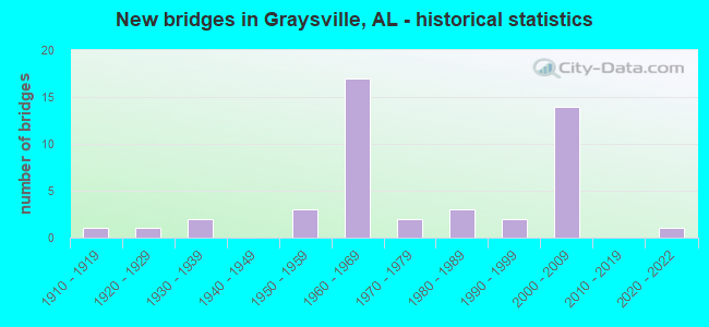
- New bridges - historical statistics
- 11910-1919
- 11920-1929
- 21930-1939
- 31950-1959
- 171960-1969
- 21970-1979
- 31980-1989
- 21990-1999
- 142000-2009
- 12020-2022


- Bridge Condition - Deck
- 6.9%Very good
- 27.6%Good
- 27.6%Satisfactory
- 37.9%Fair

- Bridge Condition - Superstructure
- 10.3%Very good
- 24.1%Good
- 37.9%Satisfactory
- 27.6%Fair

- Bridge Condition - Substructure
- 6.9%Very good
- 31.0%Good
- 51.7%Satisfactory
- 10.3%Fair

- Bridge Condition - Channel
- 22.7%Good
- 63.6%Satisfactory
- 13.6%Fair

- Bridge Condition - Culverts
- 12.5%Good
- 50.0%Satisfactory
- 37.5%Fair
Find on map >> Show street view
Structure Number: 83, Location: 100' W BAXTER AVE (Lat: 33.628747, Lng: -86.939411), Route carried "on" structure: County highway 102, Year Built: 1930, Status: Open, Structure Length: 1.52m (4.99ft), Average Daily Traffic: 1,002 (year 2021), Truck Traffic: 12%, Average Future Daily Traffic: 2,600 (year 2041), Features Intersected: PRUDES CREEK, Facility Carried by Structure: CHERRY AVE.
Minimum Vertical Clearance: 30+ m (98+ ft), Kilometerpoint: 0.010, Lanes on structure: 2, Owner: County Highway Agency, Approaching Roadway Width: 6.7m (22.0ft), Material/Design: Concrete, Design/Construction: Arch - Deck, Number Of Spans In Main Unit: 1, Length of Maximum Span: 15.2m (49.9ft), Curb or Sidewalk Widths: Left: 0.5m (1.6ft), Right: 0.5m (1.6ft), Curb-To-Curb Width: 7.9m (25.9ft), Out-to-Out Width: 8.9m (29.2ft)
Condition: Deck: Fair, Superstructure: Fair, Substructure: Fair, Channel: Fair, Operating Rating: 32.7 metric tons, Method Used To Determine Operating Rating: Field evaluation and documented engineering judgment, Inventory Rating: 24.5 metric tons, Method Used To Determine Inventory Rating: Field evaluation and documented engineering judgment, Structural Evaluation: Somewhat better than minimum adequacy, Deck Geometry: Meets minimum limits, Waterway Adequacy: Equal to present minimum criteria, Approach Roadway Alignment: Somewhat better than minimum adequacy, Length Of Structure Improvement: 2.20m (7.22ft), Designated Inspection Frequency: Every 24 months, Inspection Date: September 2021, Bridge Improvement Cost: $438,000, Roadway Improvement Cost: $44,000, Total Project Cost: $482,000 ( Estimate for 2022)
Find on map >> Show street view
Structure Number: 1772, Location: AVENUE W ENS * VILLAGE CK (Lat: 33.533333, Lng: -86.866667), Route carried "on" structure: City street , Year Built: 1938, Status: Open, Structure Length: 3.19m (10.47ft), Average Daily Traffic: 20,200 (year 2016), Truck Traffic: 30%, Average Future Daily Traffic: 30,000 (year 2036), Features Intersected: VILLAGE CK, Facility Carried by Structure: AV W
Minimum Vertical Clearance: 30+ m (98+ ft), Kilometerpoint: 3.000, Lanes on structure: 4, Owner: City or Municipal Highway Agency, Approaching Roadway Width: 14.9m (48.9ft), Skew: 1 degrees, Material/Design: Concrete, Design/Construction: Slab, Number Of Spans In Main Unit: 4, Length of Maximum Span: 7.9m (25.9ft), Curb or Sidewalk Widths: Left: 0.6m (2.0ft), Right: 0.6m (2.0ft), Curb-To-Curb Width: 15.0m (49.2ft), Out-to-Out Width: 16.2m (53.1ft)
Condition: Deck: Satisfactory, Superstructure: Satisfactory, Substructure: Satisfactory, Channel: Satisfactory, Operating Rating: 43.5 metric tons, Method Used To Determine Operating Rating: Field evaluation and documented engineering judgment, Inventory Rating: 32.7 metric tons, Method Used To Determine Inventory Rating: Field evaluation and documented engineering judgment, Structural Evaluation: Equal to present minimum criteria, Deck Geometry: High priority of replacement, Waterway Adequacy: Equal to present minimum criteria, Approach Roadway Alignment: Equal to present minimum criteria, Length Of Structure Improvement: 4.05m (13.29ft), Designated Inspection Frequency: Every 24 months, Inspection Date: September 2020, Bridge Improvement Cost: $1,472,000, Roadway Improvement Cost: $147,000, Total Project Cost: $1,619,000 ( Estimate for 2022), Deck Structure Type: Concrete Cast-file-Place, Wearing Surface/Protective System: Wearing Surface: Bituminous
Find on map >> Show street view
Structure Number: 7121, Location: 1.2 MI N HWY 78 (Lat: 33.624550, Lng: -86.954267), Route carried "on" structure: County highway 112, Year Built: 1960, Status: Open, Structure Length: 0.73m (2.40ft), Average Daily Traffic: 1,355 (year 2017), Truck Traffic: 5%, Average Future Daily Traffic: 1,578 (year 2041), Features Intersected: FIELDS BRANCH, Facility Carried by Structure: GLASGOW HOLLOW RD
Minimum Vertical Clearance: 30+ m (98+ ft), Kilometerpoint: 0.010, Lanes on structure: 2, Owner: City or Municipal Highway Agency, Approaching Roadway Width: 6.6m (21.7ft), Material/Design: Concrete, Design/Construction: Frame, Number Of Spans In Main Unit: 1, Length of Maximum Span: 6.1m (20.0ft), Curb or Sidewalk Widths: Left: 0.5m (1.6ft), Right: 0.3m (1.0ft), Curb-To-Curb Width: 7.7m (25.3ft), Out-to-Out Width: 8.5m (27.9ft)
Condition: Deck: Satisfactory, Superstructure: Satisfactory, Substructure: Fair, Channel: Fair, Operating Rating: 32.7 metric tons, Method Used To Determine Operating Rating: Field evaluation and documented engineering judgment, Inventory Rating: 24.5 metric tons, Method Used To Determine Inventory Rating: Field evaluation and documented engineering judgment, Structural Evaluation: Somewhat better than minimum adequacy, Deck Geometry: Meets minimum limits, Waterway Adequacy: Equal to present minimum criteria, Approach Roadway Alignment: Equal to present minimum criteria, Length Of Structure Improvement: 1.37m (4.49ft), Designated Inspection Frequency: Every 24 months, Inspection Date: May 2021, Bridge Improvement Cost: $253,000, Roadway Improvement Cost: $25,000, Total Project Cost: $278,000 ( Estimate for 2022), Deck Structure Type: Concrete Cast-file-Place, Wearing Surface/Protective System: Wearing Surface: Bituminous
Find on map >> Show street view
Structure Number: 7325, Location: US 78 * CANE CK (Lat: 33.692350, Lng: -86.981500), Route carried "on" structure: State highway 5, Year Built: 1961, Status: Open, Structure Length: 1.01m (3.31ft), Average Daily Traffic: 10,054 (year 2021), Truck Traffic: 11%, Average Future Daily Traffic: 18,162 (year 2041), Design Load: H 20, Features Intersected: CANE CK
Minimum Vertical Clearance: 30+ m (98+ ft), Kilometerpoint: 241.508, Lanes on structure: 4, Base Highway Network: Yes, Owner: State Highway Agency, Approaching Roadway Width: 24.4m (80.1ft), Material/Design: Concrete, Design/Construction: Culvert, Number Of Spans In Main Unit: 3, Length of Maximum Span: 3.0m (9.8ft)
Condition: Channel: Satisfactory, Culverts: Fair, Operating Rating: 88.9 metric tons, Method Used To Determine Operating Rating: Load Factor (LF), Inventory Rating: 88.9 metric tons, Method Used To Determine Inventory Rating: Load Factor (LF), Structural Evaluation: Somewhat better than minimum adequacy, Waterway Adequacy: Equal to present minimum criteria, Approach Roadway Alignment: Equal to present desirable criteria, Length Of Structure Improvement: 1.68m (5.51ft), Designated Inspection Frequency: Every 24 months, Inspection Date: March 2021, Bridge Improvement Cost: $2,232,000, Roadway Improvement Cost: $223,000, Total Project Cost: $2,455,000 ( Estimate for 2022), Wearing Surface/Protective System: Wearing Surface: Bituminous
Find on map >> Show street view
Structure Number: 7326, Location: US 78 GRAYSVILLE INTR (Lat: 33.627983, Lng: -86.977200), Route carried "on" structure: State highway 5, Year Built: 1961, Status: Open, Structure Length: 6.92m (22.70ft), Average Daily Traffic: 13,850 (year 2021), Truck Traffic: 11%, Average Future Daily Traffic: 17,340 (year 2041), Design Load: HS 20, Features Intersected: FLAT TOP RD
Minimum Vertical Clearance: 30+ m (98+ ft), Kilometerpoint: 234.147, Lanes on structure: 2, Lanes under structure: 2, Base Highway Network: Yes, Owner: State Highway Agency, Approaching Roadway Width: 8.5m (27.9ft), Material/Design: Steel, Design/Construction: Stringer/Multi-beam, Number Of Spans In Main Unit: 3, Length of Maximum Span: 25.0m (82.0ft), Curb-To-Curb Width: 8.5m (27.9ft), Out-to-Out Width: 9.4m (30.8ft)
Condition: Deck: Fair, Superstructure: Fair, Substructure: Satisfactory, Operating Rating: 51.8 metric tons, Method Used To Determine Operating Rating: Load Factor (LF), Inventory Rating: 31.0 metric tons, Method Used To Determine Inventory Rating: Load Factor (LF), Structural Evaluation: Somewhat better than minimum adequacy, Deck Geometry: High priority of corrective action, Underclear: Somewhat better than minimum adequacy, Approach Roadway Alignment: Better than present minimum criteria, Length Of Structure Improvement: 7.95m (26.08ft), Designated Inspection Frequency: Every 24 months, Inspection Date: May 2021, Bridge Improvement Cost: $1,636,000, Roadway Improvement Cost: $164,000, Total Project Cost: $1,800,000 ( Estimate for 2022), Deck Structure Type: Concrete Cast-file-Place, Wearing Surface/Protective System: Wearing Surface: Bituminous
Find on map >> Show street view
Structure Number: 7327, Location: US 78 GRAYSVILLE INTR (Lat: 33.627983, Lng: -86.977200), Route carried "on" structure: State highway 5, Year Built: 1961, Status: Open, Structure Length: 6.92m (22.70ft), Average Daily Traffic: 13,850 (year 2021), Truck Traffic: 11%, Average Future Daily Traffic: 17,340 (year 2041), Design Load: HS 20, Features Intersected: FLAT TOP ROAD
Minimum Vertical Clearance: 30+ m (98+ ft), Kilometerpoint: 234.147, Lanes on structure: 2, Lanes under structure: 2, Base Highway Network: Yes, Owner: State Highway Agency, Approaching Roadway Width: 8.5m (27.9ft), Material/Design: Steel, Design/Construction: Stringer/Multi-beam, Number Of Spans In Main Unit: 3, Length of Maximum Span: 25.0m (82.0ft), Curb-To-Curb Width: 8.5m (27.9ft), Out-to-Out Width: 9.4m (30.8ft)
Condition: Deck: Fair, Superstructure: Fair, Substructure: Satisfactory, Operating Rating: 51.7 metric tons, Method Used To Determine Operating Rating: Load Factor (LF), Inventory Rating: 30.9 metric tons, Method Used To Determine Inventory Rating: Load Factor (LF), Structural Evaluation: Somewhat better than minimum adequacy, Deck Geometry: High priority of corrective action, Underclear: Somewhat better than minimum adequacy, Approach Roadway Alignment: Equal to present desirable criteria, Length Of Structure Improvement: 7.95m (26.08ft), Designated Inspection Frequency: Every 24 months, Inspection Date: May 2021, Bridge Improvement Cost: $1,636,000, Roadway Improvement Cost: $164,000, Total Project Cost: $1,800,000 ( Estimate for 2022), Deck Structure Type: Concrete Cast-file-Place, Wearing Surface/Protective System: Wearing Surface: Bituminous
Find on map >> Show street view
Structure Number: 7328, Location: AL - 5 / 7TH AVE SW (Lat: 33.621369, Lng: -86.975111), Route carried "on" structure: City street , Year Built: 1961, Status: Open, Structure Length: 7.47m (24.51ft), Average Daily Traffic: 2,250 (year 2021), Truck Traffic: 1%, Average Future Daily Traffic: 3,200 (year 2041), Design Load: H 20, Features Intersected: AL - 5 (US 78), Facility Carried by Structure: 7TH AVE SW
Minimum Vertical Clearance: 30+ m (98+ ft), Kilometerpoint: 0.010, Lanes on structure: 2, Lanes under structure: 4, Owner: State Highway Agency, Approaching Roadway Width: 7.3m (24.0ft), Material/Design: Concrete continuous, Design/Construction: Tee Beam, Number Of Spans In Main Unit: 4, Length of Maximum Span: 20.7m (67.9ft), Curb-To-Curb Width: 7.3m (24.0ft), Out-to-Out Width: 7.3m (24.0ft)
Condition: Deck: Satisfactory, Superstructure: Satisfactory, Substructure: Satisfactory, Operating Rating: 41.0 metric tons, Method Used To Determine Operating Rating: Load Factor (LF), Inventory Rating: 24.6 metric tons, Method Used To Determine Inventory Rating: Load Factor (LF), Structural Evaluation: Equal to present minimum criteria, Deck Geometry: High priority of replacement, Underclear: Equal to present minimum criteria, Approach Roadway Alignment: Equal to present minimum criteria, Length Of Structure Improvement: 8.49m (27.85ft), Designated Inspection Frequency: Every 24 months, Inspection Date: May 2021, Bridge Improvement Cost: $1,397,000, Roadway Improvement Cost: $140,000, Total Project Cost: $1,537,000 ( Estimate for 2022), Deck Structure Type: Concrete Cast-file-Place
Find on map >> Show street view
Structure Number: 7628, Location: EAST OF SAYRE (Lat: 33.694933, Lng: -86.985117), Route carried "on" structure: State highway 5, Year Built: 1962, Status: Open, Structure Length: 3.84m (12.60ft), Average Daily Traffic: 9,305 (year 2021), Truck Traffic: 13%, Average Future Daily Traffic: 11,649 (year 2041), Design Load: HS 20, Features Intersected: L * N RR(ABANDONED)
Minimum Vertical Clearance: 30+ m (98+ ft), Kilometerpoint: 241.954, Lanes on structure: 2, Base Highway Network: Yes, Owner: State Highway Agency, Approaching Roadway Width: 12.2m (40.0ft), Material/Design: Concrete, Design/Construction: Tee Beam, Number Of Spans In Main Unit: 3, Length of Maximum Span: 12.8m (42.0ft), Curb-To-Curb Width: 8.5m (27.9ft), Out-to-Out Width: 9.4m (30.8ft)
Condition: Deck: Fair, Superstructure: Satisfactory, Substructure: Satisfactory, Operating Rating: 50.4 metric tons, Method Used To Determine Operating Rating: Load Factor (LF), Inventory Rating: 30.3 metric tons, Method Used To Determine Inventory Rating: Load Factor (LF), Structural Evaluation: Equal to present minimum criteria, Deck Geometry: High priority of corrective action, Approach Roadway Alignment: Equal to present desirable criteria, Length Of Structure Improvement: 4.78m (15.68ft), Designated Inspection Frequency: Every 24 months, Inspection Date: July 2021, Bridge Improvement Cost: $983,000, Roadway Improvement Cost: $98,000, Total Project Cost: $1,081,000 ( Estimate for 2022), Deck Structure Type: Concrete Cast-file-Place
Find on map >> Show street view
Structure Number: 7629, Location: US 78 * L * N RR (Lat: 33.693333, Lng: -86.986667), Route carried "on" structure: State highway 5, Year Built: 1962, Status: Open, Structure Length: 3.84m (12.60ft), Average Daily Traffic: 9,305 (year 2021), Truck Traffic: 13%, Average Future Daily Traffic: 11,649 (year 2041), Design Load: HS 20, Features Intersected: L * N RR (ABANDONED)
Minimum Vertical Clearance: 30+ m (98+ ft), Kilometerpoint: 241.954, Lanes on structure: 2, Base Highway Network: Yes, Owner: State Highway Agency, Approaching Roadway Width: 8.5m (27.9ft), Material/Design: Concrete, Design/Construction: Tee Beam, Number Of Spans In Main Unit: 3, Length of Maximum Span: 12.8m (42.0ft), Curb-To-Curb Width: 8.5m (27.9ft), Out-to-Out Width: 9.4m (30.8ft)
Condition: Deck: Fair, Superstructure: Satisfactory, Substructure: Satisfactory, Operating Rating: 49.2 metric tons, Method Used To Determine Operating Rating: Load Factor (LF), Inventory Rating: 29.4 metric tons, Method Used To Determine Inventory Rating: Load Factor (LF), Structural Evaluation: Equal to present minimum criteria, Deck Geometry: High priority of corrective action, Approach Roadway Alignment: Equal to present desirable criteria, Length Of Structure Improvement: 4.78m (15.68ft), Designated Inspection Frequency: Every 24 months, Inspection Date: July 2021, Bridge Improvement Cost: $983,000, Roadway Improvement Cost: $98,000, Total Project Cost: $1,081,000 ( Estimate for 2022), Deck Structure Type: Concrete Cast-file-Place
Find on map >> Show street view
Structure Number: 763, Location: @ OLD JASPER HWY (Lat: 33.679700, Lng: -86.972850), Route carried "on" structure: State highway 5, Year Built: 1962, Status: Temporarily open, Structure Length: 3.81m (12.50ft), Average Daily Traffic: 6,240 (year 2022), Truck Traffic: 12%, Average Future Daily Traffic: 7,812 (year 2042), Design Load: HS 20, Features Intersected: SOUTHERN RR
Minimum Vertical Clearance: 30+ m (98+ ft), Kilometerpoint: 240.034, Lanes on structure: 2, Base Highway Network: Yes, Owner: State Highway Agency, Approaching Roadway Width: 12.2m (40.0ft), Material/Design: Steel, Design/Construction: Stringer/Multi-beam, Number Of Spans In Main Unit: 1, Number Of Approach Spans: 1, Length of Maximum Span: 24.7m (81.0ft), Curb-To-Curb Width: 8.5m (27.9ft), Out-to-Out Width: 9.4m (30.8ft)
Condition: Deck: Fair, Superstructure: Fair, Substructure: Satisfactory, Operating Rating: 54.3 metric tons, Method Used To Determine Operating Rating: Load Factor (LF), Inventory Rating: 32.7 metric tons, Method Used To Determine Inventory Rating: Load Factor (LF), Structural Evaluation: Somewhat better than minimum adequacy, Deck Geometry: High priority of corrective action, Underclear: Meets minimum limits, Approach Roadway Alignment: Better than present minimum criteria, Length Of Structure Improvement: 4.75m (15.58ft), Designated Inspection Frequency: Every 24 months, Inspection Date: January 2022, Bridge Improvement Cost: $976,000, Roadway Improvement Cost: $98,000, Total Project Cost: $1,074,000 ( Estimate for 2022), Deck Structure Type: Concrete Cast-file-Place, Wearing Surface/Protective System: Wearing Surface: Bituminous
Find on map >> Show street view
Structure Number: 7631, Location: @ OLD JASPER HWY (Lat: 33.679700, Lng: -86.972850), Route carried "on" structure: State highway 5, Year Built: 1962, Status: Open, Structure Length: 3.26m (10.70ft), Average Daily Traffic: 6,240 (year 2022), Truck Traffic: 12%, Average Future Daily Traffic: 7,812 (year 2042), Design Load: HS 20, Features Intersected: SOU RR
Minimum Vertical Clearance: 30+ m (98+ ft), Kilometerpoint: 240.034, Lanes on structure: 2, Base Highway Network: Yes, Owner: State Highway Agency, Approaching Roadway Width: 10.7m (35.1ft), Skew: 2 degrees, Material/Design: Steel, Design/Construction: Stringer/Multi-beam, Number Of Spans In Main Unit: 1, Number Of Approach Spans: 1, Length of Maximum Span: 24.7m (81.0ft), Curb-To-Curb Width: 8.5m (27.9ft), Out-to-Out Width: 9.4m (30.8ft)
Condition: Deck: Fair, Superstructure: Fair, Substructure: Satisfactory, Operating Rating: 54.3 metric tons, Method Used To Determine Operating Rating: Load Factor (LF), Inventory Rating: 32.7 metric tons, Method Used To Determine Inventory Rating: Load Factor (LF), Structural Evaluation: Somewhat better than minimum adequacy, Deck Geometry: High priority of corrective action, Underclear: Meets minimum limits, Approach Roadway Alignment: Better than present minimum criteria, Length Of Structure Improvement: 4.13m (13.55ft), Designated Inspection Frequency: Every 24 months, Inspection Date: January 2022, Bridge Improvement Cost: $851,000, Roadway Improvement Cost: $85,000, Total Project Cost: $936,000 ( Estimate for 2022), Deck Structure Type: Concrete Cast-file-Place
Find on map >> Show street view
Structure Number: 7632, Location: @ BECKY LYNN RD (Lat: 33.678800, Lng: -86.972600), Route carried "on" structure: State highway 5, Year Built: 1962, Status: Open, Structure Length: 3.84m (12.60ft), Average Daily Traffic: 6,240 (year 2022), Truck Traffic: 12%, Average Future Daily Traffic: 7,812 (year 2042), Design Load: HS 20, Features Intersected: ABANDONED RR
Minimum Vertical Clearance: 30+ m (98+ ft), Kilometerpoint: 239.873, Lanes on structure: 2, Base Highway Network: Yes, Owner: State Highway Agency, Approaching Roadway Width: 12.2m (40.0ft), Material/Design: Concrete, Design/Construction: Tee Beam, Number Of Spans In Main Unit: 3, Length of Maximum Span: 12.8m (42.0ft), Curb-To-Curb Width: 8.5m (27.9ft), Out-to-Out Width: 9.4m (30.8ft)
Condition: Deck: Satisfactory, Superstructure: Satisfactory, Substructure: Satisfactory, Operating Rating: 50.4 metric tons, Method Used To Determine Operating Rating: Load Factor (LF), Inventory Rating: 30.3 metric tons, Method Used To Determine Inventory Rating: Load Factor (LF), Structural Evaluation: Equal to present minimum criteria, Deck Geometry: High priority of corrective action, Underclear: Somewhat better than minimum adequacy, Approach Roadway Alignment: Equal to present minimum criteria, Length Of Structure Improvement: 4.78m (15.68ft), Designated Inspection Frequency: Every 24 months, Inspection Date: Febuary 2022, Bridge Improvement Cost: $983,000, Roadway Improvement Cost: $98,000, Total Project Cost: $1,081,000 ( Estimate for 2022), Deck Structure Type: Concrete Cast-file-Place, Wearing Surface/Protective System: Wearing Surface: Bituminous
Find on map >> Show street view
Structure Number: 7633, Location: @ BECKY LYNN RD (Lat: 33.678800, Lng: -86.972900), Route carried "on" structure: State highway 5, Year Built: 1962, Status: Open, Structure Length: 3.84m (12.60ft), Average Daily Traffic: 6,240 (year 2022), Truck Traffic: 12%, Average Future Daily Traffic: 7,812 (year 2042), Design Load: HS 20, Features Intersected: ABANDONED RR
Minimum Vertical Clearance: 30+ m (98+ ft), Kilometerpoint: 239.873, Lanes on structure: 2, Base Highway Network: Yes, Owner: State Highway Agency, Approaching Roadway Width: 10.7m (35.1ft), Material/Design: Concrete, Design/Construction: Tee Beam, Number Of Spans In Main Unit: 3, Length of Maximum Span: 12.8m (42.0ft), Curb-To-Curb Width: 8.5m (27.9ft), Out-to-Out Width: 10.1m (33.1ft)
Condition: Deck: Fair, Superstructure: Satisfactory, Substructure: Satisfactory, Operating Rating: 41.0 metric tons, Method Used To Determine Operating Rating: Load Factor (LF), Inventory Rating: 24.6 metric tons, Method Used To Determine Inventory Rating: Load Factor (LF), Structural Evaluation: Equal to present minimum criteria, Deck Geometry: High priority of corrective action, Underclear: Somewhat better than minimum adequacy, Approach Roadway Alignment: Better than present minimum criteria, Length Of Structure Improvement: 4.78m (15.68ft), Designated Inspection Frequency: Every 24 months, Inspection Date: Febuary 2022, Bridge Improvement Cost: $1,082,000, Roadway Improvement Cost: $108,000, Total Project Cost: $1,190,000 ( Estimate for 2022), Deck Structure Type: Concrete Cast-file-Place
Find on map >> Show street view
Structure Number: 7634, Location: US 78 * FIVE MI CK (Lat: 33.663983, Lng: -86.970633), Route carried "on" structure: State highway 5, Year Built: 1962, Status: Open, Structure Length: 10.97m (35.99ft), Average Daily Traffic: 6,240 (year 2022), Truck Traffic: 12%, Average Future Daily Traffic: 7,812 (year 2042), Design Load: HS 20, Features Intersected: FIVE MI CK
Minimum Vertical Clearance: 30+ m (98+ ft), Kilometerpoint: 238.109, Lanes on structure: 2, Base Highway Network: Yes, Owner: State Highway Agency, Approaching Roadway Width: 12.2m (40.0ft), Material/Design: Steel, Design/Construction: Stringer/Multi-beam, Number Of Spans In Main Unit: 3, Number Of Approach Spans: 3, Length of Maximum Span: 24.4m (80.1ft), Curb-To-Curb Width: 8.5m (27.9ft), Out-to-Out Width: 10.1m (33.1ft)
Condition: Deck: Fair, Superstructure: Fair, Substructure: Satisfactory, Channel: Satisfactory, Operating Rating: 48.5 metric tons, Method Used To Determine Operating Rating: Allowable Stress (AS), Inventory Rating: 29.1 metric tons, Method Used To Determine Inventory Rating: Allowable Stress (AS), Structural Evaluation: Somewhat better than minimum adequacy, Deck Geometry: High priority of corrective action, Waterway Adequacy: Equal to present desirable criteria, Approach Roadway Alignment: Better than present minimum criteria, Length Of Structure Improvement: 11.86m (38.91ft), Designated Inspection Frequency: Every 24 months, Inspection Date: Febuary 2022, Bridge Improvement Cost: $2,685,000, Roadway Improvement Cost: $269,000, Total Project Cost: $2,954,000 ( Estimate for 2022), Deck Structure Type: Concrete Cast-file-Place, Wearing Surface/Protective System: Wearing Surface: Bituminous
Find on map >> Show street view
Structure Number: 7635, Location: US 78 * FIVE MI CK (Lat: 33.663983, Lng: -86.970633), Route carried "on" structure: State highway 5, Year Built: 1962, Status: Open, Structure Length: 10.97m (35.99ft), Average Daily Traffic: 6,240 (year 2022), Truck Traffic: 12%, Average Future Daily Traffic: 7,812 (year 2042), Design Load: HS 20, Features Intersected: FIVE MI CK
Minimum Vertical Clearance: 30+ m (98+ ft), Kilometerpoint: 238.109, Lanes on structure: 2, Base Highway Network: Yes, Owner: State Highway Agency, Approaching Roadway Width: 12.2m (40.0ft), Material/Design: Steel, Design/Construction: Stringer/Multi-beam, Number Of Spans In Main Unit: 3, Number Of Approach Spans: 3, Length of Maximum Span: 24.4m (80.1ft), Curb-To-Curb Width: 8.5m (27.9ft), Out-to-Out Width: 9.4m (30.8ft)
Condition: Deck: Fair, Superstructure: Fair, Substructure: Satisfactory, Channel: Satisfactory, Operating Rating: 41.4 metric tons, Method Used To Determine Operating Rating: Load Factor (LF), Inventory Rating: 24.9 metric tons, Method Used To Determine Inventory Rating: Load Factor (LF), Structural Evaluation: Somewhat better than minimum adequacy, Deck Geometry: High priority of corrective action, Waterway Adequacy: Equal to present desirable criteria, Approach Roadway Alignment: Better than present minimum criteria, Length Of Structure Improvement: 11.86m (38.91ft), Designated Inspection Frequency: Every 24 months, Inspection Date: Febuary 2022, Bridge Improvement Cost: $2,522,000, Roadway Improvement Cost: $252,000, Total Project Cost: $2,774,000 ( Estimate for 2022), Deck Structure Type: Concrete Cast-file-Place
Find on map >> Show street view
Structure Number: 95, Location: 2 MILES NE OF ROBBINS (Lat: 33.745950, Lng: -86.958183), Route carried "on" structure: County highway 134, Year Built: 1950, Status: Open, Structure Length: 1.96m (6.43ft), Average Daily Traffic: 686 (year 2020), Truck Traffic: 1%, Average Future Daily Traffic: 950 (year 2040), Design Load: HS 20, Features Intersected: CAMPBELL CREEK, Facility Carried by Structure: RIVER ROAD
Minimum Vertical Clearance: 30+ m (98+ ft), Kilometerpoint: 0.000, Lanes on structure: 2, Owner: County Highway Agency, Approaching Roadway Width: 7.2m (23.6ft), Material/Design: Concrete, Design/Construction: Slab, Number Of Spans In Main Unit: 3, Length of Maximum Span: 5.5m (18.0ft), Curb or Sidewalk Widths: Left: 0.3m (1.0ft), Right: 0.3m (1.0ft), Curb-To-Curb Width: 8.7m (28.5ft), Out-to-Out Width: 9.9m (32.5ft)
Condition: Deck: Fair, Superstructure: Fair, Substructure: Fair, Channel: Fair, Operating Rating: 32.7 metric tons, Method Used To Determine Operating Rating: Field evaluation and documented engineering judgment, Inventory Rating: 24.5 metric tons, Method Used To Determine Inventory Rating: Field evaluation and documented engineering judgment, Structural Evaluation: Somewhat better than minimum adequacy, Deck Geometry: Somewhat better than minimum adequacy, Waterway Adequacy: Somewhat better than minimum adequacy, Approach Roadway Alignment: Better than present minimum criteria, Length Of Structure Improvement: 2.70m (8.86ft), Designated Inspection Frequency: Every 24 months, Inspection Date: April 2020, Bridge Improvement Cost: $593,000, Roadway Improvement Cost: $59,000, Total Project Cost: $652,000 ( Estimate for 2022), Deck Structure Type: Concrete Cast-file-Place, Wearing Surface/Protective System: Wearing Surface: Bituminous
Find on map >> Show street view
Structure Number: 10793, Location: SAYRE (Lat: 33.709467, Lng: -86.983283), Route carried "on" structure: County highway 124, Year Built: 1972, Status: Open, Structure Length: 15.19m (49.84ft), Average Daily Traffic: 631 (year 2017), Truck Traffic: 2%, Average Future Daily Traffic: 875 (year 2037), Design Load: HS 20, Features Intersected: BLACK WARRIOR LOCUSTFORK, Facility Carried by Structure: OLD JASPER HWY
Minimum Vertical Clearance: 30+ m (98+ ft), Kilometerpoint: 0.010, Lanes on structure: 2, Owner: County Highway Agency, Approaching Roadway Width: 7.5m (24.6ft), Skew: 4 degrees, Material/Design: Steel continuous, Design/Construction: Girder and Floorbeam System, Number Of Spans In Main Unit: 3, Number Of Approach Spans: 1, Length of Maximum Span: 54.9m (180.1ft), Curb or Sidewalk Widths: Left: 0.2m (0.7ft), Right: 0.2m (0.7ft), Curb-To-Curb Width: 8.5m (27.9ft), Out-to-Out Width: 9.6m (31.5ft)
Condition: Deck: Good, Superstructure: Good, Substructure: Good, Channel: Good, Operating Rating: 44.2 metric tons, Method Used To Determine Operating Rating: Allowable Stress (AS), Inventory Rating: 28.5 metric tons, Method Used To Determine Inventory Rating: Allowable Stress (AS), Structural Evaluation: Better than present minimum criteria, Deck Geometry: Somewhat better than minimum adequacy, Waterway Adequacy: Equal to present desirable criteria, Approach Roadway Alignment: Better than present minimum criteria, Length Of Structure Improvement: 15.96m (52.36ft), Designated Inspection Frequency: Every 24 months, Critical Feature Inspection Frequency: Every 24 months, Inspection Date: June 2021, Critical Feature Inspection Date: June 2021, Bridge Improvement Cost: $3,392,000, Roadway Improvement Cost: $339,000, Total Project Cost: $3,731,000 ( Estimate for 2022), Deck Structure Type: Concrete Cast-file-Place
Find on map >> Show street view
Structure Number: 11047, Location: 2 MI W SAYRE (Lat: 33.723200, Lng: -87.003800), Route carried "on" structure: State highway 5, Year Built: 1952, Year Reconstructed: 1974, Status: Open, Structure Length: 1.34m (4.40ft), Average Daily Traffic: 14,660 (year 2021), Truck Traffic: 13%, Average Future Daily Traffic: 18,354 (year 2041), Design Load: H 15, Features Intersected: BRANCH
Minimum Vertical Clearance: 7.56m (24.80ft), Kilometerpoint: 245.641, Lanes on structure: 4, Base Highway Network: Yes, Owner: State Highway Agency, Approaching Roadway Width: 13.4m (44.0ft), Material/Design: Concrete, Design/Construction: Culvert, Number Of Spans In Main Unit: 4, Length of Maximum Span: 3.0m (9.8ft)
Condition: Channel: Satisfactory, Culverts: Satisfactory, Operating Rating: 88.9 metric tons, Method Used To Determine Operating Rating: Load Factor (LF), Inventory Rating: 88.9 metric tons, Method Used To Determine Inventory Rating: Load Factor (LF), Structural Evaluation: Equal to present minimum criteria, Waterway Adequacy: Equal to present minimum criteria, Approach Roadway Alignment: Meets minimum limits, Length Of Structure Improvement: 2.02m (6.63ft), Designated Inspection Frequency: Every 24 months, Inspection Date: September 2021, Bridge Improvement Cost: $2,130,000, Roadway Improvement Cost: $213,000, Total Project Cost: $2,343,000 ( Estimate for 2022), Wearing Surface/Protective System: Wearing Surface: Bituminous
Find on map >> Show street view
Structure Number: 1224, Location: 1.5 MI E RIVER ROAD (Lat: 33.727669, Lng: -86.970086), Route carried "on" structure: County highway 853, Year Built: 1979, Status: Open, Structure Length: 1.98m (6.50ft), Average Daily Traffic: 103 (year 2020), Truck Traffic: 1%, Average Future Daily Traffic: 150 (year 2040), Design Load: H 20, Features Intersected: CAMPBELL CREEK, Facility Carried by Structure: RED ROCK ROAD
Minimum Vertical Clearance: 30+ m (98+ ft), Kilometerpoint: 0.010, Lanes on structure: 2, Owner: County Highway Agency, Approaching Roadway Width: 5.8m (19.0ft), Material/Design: Steel, Design/Construction: Culvert, Number Of Spans In Main Unit: 4, Length of Maximum Span: 3.0m (9.8ft)
Condition: Channel: Satisfactory, Culverts: Satisfactory, Operating Rating: 83.6 metric tons, Method Used To Determine Operating Rating: Load Factor (LF), Inventory Rating: 83.6 metric tons, Method Used To Determine Inventory Rating: Load Factor (LF), Structural Evaluation: Equal to present minimum criteria, Waterway Adequacy: Equal to present minimum criteria, Approach Roadway Alignment: Somewhat better than minimum adequacy, Length Of Structure Improvement: 2.73m (8.96ft), Designated Inspection Frequency: Every 24 months, Inspection Date: August 2020, Bridge Improvement Cost: $677,000, Roadway Improvement Cost: $68,000, Total Project Cost: $745,000 ( Estimate for 2022)
Find on map >> Show street view
Structure Number: 1235, Location: 3 MI E OF SUMITON (Lat: 33.704400, Lng: -86.992100), Route carried "on" structure: State highway 5, Year Built: 1980, Status: Open, Structure Length: 14.20m (46.59ft), Average Daily Traffic: 9,305 (year 2020), Truck Traffic: 13%, Average Future Daily Traffic: 11,649 (year 2040), Design Load: HS 20, Features Intersected: LOCUST FORK WARRIORRIVER
Minimum Vertical Clearance: 30+ m (98+ ft), Kilometerpoint: 243.386, Lanes on structure: 2, Base Highway Network: Yes, Owner: State Highway Agency, Approaching Roadway Width: 12.2m (40.0ft), Material/Design: Steel continuous, Design/Construction: Stringer/Multi-beam, Number Of Spans In Main Unit: 3, Length of Maximum Span: 54.9m (180.1ft), Curb-To-Curb Width: 12.2m (40.0ft), Out-to-Out Width: 12.6m (41.3ft)
Condition: Deck: Satisfactory, Superstructure: Satisfactory, Substructure: Satisfactory, Channel: Satisfactory, Operating Rating: 58.2 metric tons, Method Used To Determine Operating Rating: Load Factor (LF), Inventory Rating: 34.9 metric tons, Method Used To Determine Inventory Rating: Load Factor (LF), Structural Evaluation: Equal to present minimum criteria, Deck Geometry: Better than present minimum criteria, Waterway Adequacy: Equal to present desirable criteria, Approach Roadway Alignment: Equal to present desirable criteria, Length Of Structure Improvement: 14.99m (49.18ft), Designated Inspection Frequency: Every 24 months, Inspection Date: March 2020, Bridge Improvement Cost: $4,215,000, Roadway Improvement Cost: $422,000, Total Project Cost: $4,637,000 ( Estimate for 2022), Deck Structure Type: Concrete Cast-file-Place
Find on map >> Show street view
Structure Number: 12414, Location: 1.25 MI N LYNNS CROSSING (Lat: 33.694272, Lng: -86.972861), Route carried "on" structure: County highway 124, Year Built: 1980, Status: Open, Structure Length: 4.75m (15.58ft), Average Daily Traffic: 128 (year 2018), Truck Traffic: 1%, Average Future Daily Traffic: 175 (year 2040), Design Load: HS 20, Features Intersected: CANE CREEK, Facility Carried by Structure: OLD JASPER HI'WAY
Minimum Vertical Clearance: 30+ m (98+ ft), Kilometerpoint: 0.010, Lanes on structure: 2, Owner: City or Municipal Highway Agency, Approaching Roadway Width: 5.3m (17.4ft), Skew: 1 degrees, Material/Design: Concrete, Design/Construction: Box Beam or Girders - Multiple, Number Of Spans In Main Unit: 3, Length of Maximum Span: 15.8m (51.8ft), Curb or Sidewalk Widths: Left: 0.3m (1.0ft), Right: 0.3m (1.0ft), Curb-To-Curb Width: 7.1m (23.3ft), Out-to-Out Width: 7.9m (25.9ft)
Condition: Deck: Satisfactory, Superstructure: Satisfactory, Substructure: Satisfactory, Channel: Satisfactory, Operating Rating: 47.3 metric tons, Method Used To Determine Operating Rating: Load Factor (LF), Inventory Rating: 23.5 metric tons, Method Used To Determine Inventory Rating: Load Factor (LF), Structural Evaluation: Equal to present minimum criteria, Deck Geometry: Meets minimum limits, Waterway Adequacy: Equal to present minimum criteria, Approach Roadway Alignment: Equal to present minimum criteria, Length Of Structure Improvement: 5.76m (18.90ft), Designated Inspection Frequency: Every 24 months, Inspection Date: April 2020, Bridge Improvement Cost: $1,027,000, Roadway Improvement Cost: $103,000, Total Project Cost: $1,130,000 ( Estimate for 2022), Deck Structure Type: Concrete Precast Panels
Find on map >> Show street view
Structure Number: 12415, Location: LYNNS CROSSING (Lat: 33.671814, Lng: -86.964611), Route carried "on" structure: County highway 124, Year Built: 1980, Status: Open, Structure Length: 6.21m (20.37ft), Average Daily Traffic: 228 (year 2019), Truck Traffic: 1%, Average Future Daily Traffic: 325 (year 2039), Design Load: HS 20, Features Intersected: FIVE MILE CREEK, Facility Carried by Structure: LINNDALE ROAD
Minimum Vertical Clearance: 30+ m (98+ ft), Kilometerpoint: 0.010, Lanes on structure: 2, Owner: County Highway Agency, Approaching Roadway Width: 9.1m (29.9ft), Material/Design: Steel continuous, Design/Construction: Stringer/Multi-beam, Number Of Spans In Main Unit: 3, Length of Maximum Span: 24.4m (80.1ft), Curb-To-Curb Width: 8.5m (27.9ft), Out-to-Out Width: 9.4m (30.8ft)
Condition: Deck: Good, Superstructure: Good, Substructure: Good, Channel: Good, Operating Rating: 40.3 metric tons, Method Used To Determine Operating Rating: Load Factor (LF), Inventory Rating: 24.1 metric tons, Method Used To Determine Inventory Rating: Load Factor (LF), Structural Evaluation: Equal to present minimum criteria, Deck Geometry: Equal to present minimum criteria, Waterway Adequacy: Equal to present desirable criteria, Approach Roadway Alignment: Better than present minimum criteria, Length Of Structure Improvement: 7.25m (23.79ft), Designated Inspection Frequency: Every 24 months, Inspection Date: April 2021, Bridge Improvement Cost: $1,491,000, Roadway Improvement Cost: $149,000, Total Project Cost: $1,640,000 ( Estimate for 2022), Deck Structure Type: Concrete Cast-file-Place
Find on map >> Show street view
Structure Number: 16622, Location: .25 MI W US 78 (Lat: 33.712417, Lng: -87.001083), Route carried "on" structure: County highway 147, Year Built: 1996, Status: Open, Structure Length: 5.83m (19.13ft), Average Daily Traffic: 1,905 (year 2020), Truck Traffic: 5%, Average Future Daily Traffic: 2,650 (year 2040), Design Load: HS 20, Features Intersected: MILL CREEK, Facility Carried by Structure: SNOWVILLE-BRENT RD
Minimum Vertical Clearance: 30+ m (98+ ft), Kilometerpoint: 0.000, Lanes on structure: 2, Owner: County Highway Agency, Approaching Roadway Width: 7.3m (24.0ft), Material/Design: Prestressed concrete, Design/Construction: Stringer/Multi-beam, Number Of Spans In Main Unit: 3, Length of Maximum Span: 18.7m (61.4ft), Curb-To-Curb Width: 9.2m (30.2ft), Out-to-Out Width: 10.1m (33.1ft)
Condition: Deck: Good, Superstructure: Very good, Substructure: Very good, Channel: Good, Operating Rating: 77.3 metric tons, Method Used To Determine Operating Rating: Load Factor (LF), Inventory Rating: 50.6 metric tons, Method Used To Determine Inventory Rating: Load Factor (LF), Structural Evaluation: Equal to present desirable criteria, Deck Geometry: Somewhat better than minimum adequacy, Waterway Adequacy: Better than present minimum criteria, Approach Roadway Alignment: Equal to present desirable criteria, Length Of Structure Improvement: 6.87m (22.54ft), Designated Inspection Frequency: Every 24 months, Inspection Date: December 2020, Bridge Improvement Cost: $1,554,000, Roadway Improvement Cost: $155,000, Total Project Cost: $1,709,000 ( Estimate for 2022), Deck Structure Type: Concrete Cast-file-Place
Find on map >> Show street view
Structure Number: 167, Location: 1/4 MI SE ROBBINS XROADS (Lat: 33.733917, Lng: -86.993900), Route carried "on" structure: County highway 103, Year Built: 1950, Status: Open, Structure Length: 0.64m (2.10ft), Average Daily Traffic: 4,110 (year 2021), Truck Traffic: 5%, Average Future Daily Traffic: 5,750 (year 2041), Design Load: HS 20, Features Intersected: MILL CREEK TRIBUTARY, Facility Carried by Structure: BANKHEAD HWY
Minimum Vertical Clearance: 30+ m (98+ ft), Kilometerpoint: 0.000, Lanes on structure: 2, Owner: County Highway Agency, Approaching Roadway Width: 6.7m (22.0ft), Material/Design: Concrete continuous, Design/Construction: Culvert, Number Of Spans In Main Unit: 2, Length of Maximum Span: 3.0m (9.8ft)
Condition: Channel: Satisfactory, Culverts: Fair, Operating Rating: 88.9 metric tons, Method Used To Determine Operating Rating: Load Factor (LF), Inventory Rating: 82.4 metric tons, Method Used To Determine Inventory Rating: Load Factor (LF), Structural Evaluation: Somewhat better than minimum adequacy, Waterway Adequacy: Equal to present minimum criteria, Approach Roadway Alignment: Better than present minimum criteria, Length Of Structure Improvement: 1.26m (4.13ft), Designated Inspection Frequency: Every 24 months, Inspection Date: March 2021, Bridge Improvement Cost: $328,000, Roadway Improvement Cost: $33,000, Total Project Cost: $361,000 ( Estimate for 2022)
Find on map >> Show street view
Structure Number: 16701, Location: 300 FT S CHERRY AVE (Lat: 33.621294, Lng: -86.928403), Route carried "on" structure: County highway , Year Built: 1960, Status: Open, Structure Length: 0.70m (2.30ft), Average Daily Traffic: 1,975 (year 2017), Truck Traffic: 5%, Average Future Daily Traffic: 2,021 (year 2041), Design Load: HS 20, Features Intersected: PRUDES CREEK, Facility Carried by Structure: HILLCREST ROAD
Minimum Vertical Clearance: 30+ m (98+ ft), Kilometerpoint: 0.000, Lanes on structure: 2, Owner: County Highway Agency, Approaching Roadway Width: 7.9m (25.9ft), Material/Design: Concrete continuous, Design/Construction: Slab, Number Of Spans In Main Unit: 2, Length of Maximum Span: 3.0m (9.8ft), Curb-To-Curb Width: 7.9m (25.9ft), Out-to-Out Width: 21.0m (68.9ft)
Condition: Deck: Satisfactory, Superstructure: Good, Substructure: Good, Channel: Satisfactory, Operating Rating: 32.7 metric tons, Method Used To Determine Operating Rating: Field evaluation and documented engineering judgment, Inventory Rating: 23.6 metric tons, Method Used To Determine Inventory Rating: Field evaluation and documented engineering judgment, Structural Evaluation: Equal to present minimum criteria, Deck Geometry: Meets minimum limits, Waterway Adequacy: Better than present minimum criteria, Approach Roadway Alignment: Better than present minimum criteria, Length Of Structure Improvement: 1.34m (4.40ft), Designated Inspection Frequency: Every 24 months, Inspection Date: June 2021, Bridge Improvement Cost: $633,000, Roadway Improvement Cost: $63,000, Total Project Cost: $696,000 ( Estimate for 2022), Deck Structure Type: Concrete Cast-file-Place
Find on map >> Show street view
Structure Number: 16914, Location: 2 MI SW US 78 (Lat: 33.697753, Lng: -87.022369), Route carried "on" structure: County highway 147, Year Built: 1995, Status: Open, Structure Length: 0.67m (2.20ft), Average Daily Traffic: 2,051 (year 2021), Truck Traffic: 5%, Average Future Daily Traffic: 2,550 (year 2041), Design Load: HS 20, Features Intersected: BLACK WARRIOR R TRIBUTAR, Facility Carried by Structure: SNOWVILLE-BRENT RD
Minimum Vertical Clearance: 30+ m (98+ ft), Kilometerpoint: 0.000, Lanes on structure: 2, Owner: County Highway Agency, Approaching Roadway Width: 6.9m (22.6ft), Material/Design: Concrete, Design/Construction: Culvert, Number Of Spans In Main Unit: 2, Length of Maximum Span: 3.0m (9.8ft), Curb-To-Curb Width: 12.7m (41.7ft), Out-to-Out Width: 13.3m (43.6ft)
Condition: Channel: Satisfactory, Culverts: Good, Operating Rating: 69.9 metric tons, Method Used To Determine Operating Rating: Load Factor (LF), Inventory Rating: 41.9 metric tons, Method Used To Determine Inventory Rating: Load Factor (LF), Structural Evaluation: Better than present minimum criteria, Deck Geometry: Equal to present minimum criteria, Waterway Adequacy: Equal to present minimum criteria, Approach Roadway Alignment: Better than present minimum criteria, Length Of Structure Improvement: 1.30m (4.27ft), Designated Inspection Frequency: Every 24 months, Inspection Date: January 2021, Bridge Improvement Cost: $308,000, Roadway Improvement Cost: $31,000, Total Project Cost: $339,000 ( Estimate for 2022)
Find on map >> Show street view
Structure Number: 17652, Location: GRAYSVILLE INTERCHANGE (Lat: 33.645000, Lng: -86.976500), Route carried "on" structure: State highway 5, Year Built: 2001, Status: Open, Structure Length: 13.01m (42.68ft), Average Daily Traffic: 13,850 (year 2020), Truck Traffic: 11%, Average Future Daily Traffic: 17,340 (year 2040), Design Load: HS 20, Features Intersected: CORRIDOR X
Minimum Vertical Clearance: 30+ m (98+ ft), Kilometerpoint: 235.769, Lanes on structure: 2, Lanes under structure: 6, Base Highway Network: Yes, Owner: State Highway Agency, Approaching Roadway Width: 11.0m (36.1ft), Material/Design: Prestressed concrete, Design/Construction: Stringer/Multi-beam, Number Of Spans In Main Unit: 4, Length of Maximum Span: 39.6m (129.9ft), Curb-To-Curb Width: 15.8m (51.8ft), Out-to-Out Width: 16.7m (54.8ft)
Condition: Deck: Good, Superstructure: Satisfactory, Substructure: Good, Operating Rating: 62.1 metric tons, Method Used To Determine Operating Rating: Load Factor (LF), Inventory Rating: 37.2 metric tons, Method Used To Determine Inventory Rating: Load Factor (LF), Structural Evaluation: Equal to present minimum criteria, Deck Geometry: Superior to present desirable criteria, Underclear: Better than present minimum criteria, Approach Roadway Alignment: Equal to present desirable criteria, Length Of Structure Improvement: 13.84m (45.41ft), Designated Inspection Frequency: Every 24 months, Inspection Date: August 2020, Bridge Improvement Cost: $5,124,000, Roadway Improvement Cost: $512,000, Total Project Cost: $5,636,000 ( Estimate for 2022), Deck Structure Type: Concrete Cast-file-Place
Find on map >> Show street view
Structure Number: 17653, Location: GRAYSVILLE INTERCHANGE (Lat: 33.645900, Lng: -86.976600), Route carried "on" structure: State highway 5, Year Built: 2000, Status: Open, Structure Length: 13.01m (42.68ft), Average Daily Traffic: 13,850 (year 2020), Truck Traffic: 11%, Average Future Daily Traffic: 17,340 (year 2040), Design Load: HS 20, Features Intersected: I - 22
Minimum Vertical Clearance: 30+ m (98+ ft), Kilometerpoint: 235.769, Lanes on structure: 3, Lanes under structure: 6, Base Highway Network: Yes, Owner: State Highway Agency, Approaching Roadway Width: 15.8m (51.8ft), Material/Design: Prestressed concrete, Design/Construction: Stringer/Multi-beam, Number Of Spans In Main Unit: 4, Length of Maximum Span: 39.6m (129.9ft), Curb-To-Curb Width: 15.8m (51.8ft), Out-to-Out Width: 16.7m (54.8ft)
Condition: Deck: Satisfactory, Superstructure: Satisfactory, Substructure: Satisfactory, Operating Rating: 62.1 metric tons, Method Used To Determine Operating Rating: Load Factor (LF), Inventory Rating: 37.2 metric tons, Method Used To Determine Inventory Rating: Load Factor (LF), Structural Evaluation: Equal to present minimum criteria, Deck Geometry: Better than present minimum criteria, Underclear: Better than present minimum criteria, Approach Roadway Alignment: Equal to present desirable criteria, Length Of Structure Improvement: 13.83m (45.37ft), Designated Inspection Frequency: Every 24 months, Inspection Date: August 2020, Bridge Improvement Cost: $5,121,000, Roadway Improvement Cost: $512,000, Total Project Cost: $5,633,000 ( Estimate for 2022), Deck Structure Type: Concrete Cast-file-Place
Find on map >> Show street view
Structure Number: 17654, Location: .1 MI. NO.GRAYSVILLE INT. (Lat: 33.644492, Lng: -86.973036), Route carried "on" structure: City street 71, Year Built: 2001, Status: Open, Structure Length: 18.26m (59.91ft), Average Daily Traffic: 2,000 (year 2021), Truck Traffic: 1%, Average Future Daily Traffic: 3,000 (year 2041), Design Load: HS 20, Features Intersected: I - 22, Facility Carried by Structure: LINDALL RD
Minimum Vertical Clearance: 30+ m (98+ ft), Kilometerpoint: 0.000, Lanes on structure: 2, Lanes under structure: 8, Owner: State Highway Agency, Approaching Roadway Width: 7.4m (24.3ft), Material/Design: Steel continuous, Design/Construction: Stringer/Multi-beam, Number Of Spans In Main Unit: 3, Number Of Approach Spans: 2, Length of Maximum Span: 43.3m (142.1ft), Curb-To-Curb Width: 12.2m (40.0ft), Out-to-Out Width: 13.1m (43.0ft)
Condition: Deck: Good, Superstructure: Good, Substructure: Good, Operating Rating: 63.7 metric tons, Method Used To Determine Operating Rating: Allowable Stress (AS), Inventory Rating: 38.2 metric tons, Method Used To Determine Inventory Rating: Allowable Stress (AS), Structural Evaluation: Better than present minimum criteria, Deck Geometry: Better than present minimum criteria, Underclear: Superior to present desirable criteria, Approach Roadway Alignment: Equal to present desirable criteria, Length Of Structure Improvement: 18.92m (62.07ft), Designated Inspection Frequency: Every 24 months, Inspection Date: September 2021, Bridge Improvement Cost: $5,450,000, Roadway Improvement Cost: $545,000, Total Project Cost: $5,995,000 ( Estimate for 2022), Deck Structure Type: Concrete Cast-file-Place
Find on map >> Show street view
Structure Number: 17717, Location: .7 MI.WEST CO. RD. 112 (Lat: 33.637944, Lng: -86.957594), Route carried "on" structure: Interstate 22, Year Built: 2001, Status: Open, Structure Length: 0.79m (2.59ft), Average Daily Traffic: 12,470 (year 2021), Truck Traffic: 15%, Average Future Daily Traffic: 16,895 (year 2041), Design Load: HS 20, Features Intersected: PRUDES CREEK
Minimum Vertical Clearance: 30.18m (99.02ft), Kilometerpoint: 138.999, Lanes on structure: 6, Base Highway Network: Yes, Owner: State Highway Agency, Approaching Roadway Width: 36.6m (120.1ft), Skew: 9 degrees, Material/Design: Concrete, Design/Construction: Culvert, Number Of Spans In Main Unit: 3, Length of Maximum Span: 2.4m (7.9ft)
Condition: Channel: Good, Culverts: Fair, Operating Rating: 88.9 metric tons, Method Used To Determine Operating Rating: Load Factor (LF), Inventory Rating: 88.9 metric tons, Method Used To Determine Inventory Rating: Load Factor (LF), Structural Evaluation: Somewhat better than minimum adequacy, Waterway Adequacy: Equal to present desirable criteria, Approach Roadway Alignment: Equal to present desirable criteria, Length Of Structure Improvement: 1.45m (4.76ft), Designated Inspection Frequency: Every 24 months, Inspection Date: April 2021, Bridge Improvement Cost: $9,188,000, Roadway Improvement Cost: $919,000, Total Project Cost: $10,107,000 ( Estimate for 2022)
Find on map >> Show street view
Structure Number: 17718, Location: BLOSSBURG (Lat: 33.629681, Lng: -86.950136), Route carried "on" structure: Interstate 22, Year Built: 2002, Status: Open, Structure Length: 7.92m (25.98ft), Average Daily Traffic: 34,716 (year 2021), Truck Traffic: 15%, Average Future Daily Traffic: 62,700 (year 2041), Design Load: HS 20, Features Intersected: COUNTY RD 112
Minimum Vertical Clearance: 30+ m (98+ ft), Kilometerpoint: 140.576, Lanes on structure: 3, Lanes under structure: 2, Base Highway Network: Yes, Owner: State Highway Agency, Approaching Roadway Width: 17.1m (56.1ft), Material/Design: Prestressed concrete, Design/Construction: Stringer/Multi-beam, Number Of Spans In Main Unit: 3, Length of Maximum Span: 39.6m (129.9ft), Curb-To-Curb Width: 24.4m (80.1ft), Out-to-Out Width: 25.2m (82.7ft)
Condition: Deck: Good, Superstructure: Good, Substructure: Good, Operating Rating: 60.5 metric tons, Method Used To Determine Operating Rating: Load Factor (LF), Inventory Rating: 36.2 metric tons, Method Used To Determine Inventory Rating: Load Factor (LF), Structural Evaluation: Better than present minimum criteria, Deck Geometry: Superior to present desirable criteria, Underclear: Superior to present desirable criteria, Approach Roadway Alignment: Equal to present desirable criteria, Length Of Structure Improvement: 8.94m (29.33ft), Designated Inspection Frequency: Every 24 months, Inspection Date: April 2021, Bridge Improvement Cost: $5,024,000, Roadway Improvement Cost: $502,000, Total Project Cost: $5,526,000 ( Estimate for 2022), Deck Structure Type: Concrete Cast-file-Place
Find on map >> Show street view
Structure Number: 17719, Location: BLOSSBURG (Lat: 33.629542, Lng: -86.950339), Route carried "on" structure: Interstate 22, Year Built: 2002, Status: Open, Structure Length: 7.92m (25.98ft), Average Daily Traffic: 34,716 (year 2021), Truck Traffic: 15%, Average Future Daily Traffic: 62,700 (year 2041), Design Load: HS 20, Features Intersected: COUNTY RD 112
Minimum Vertical Clearance: 30+ m (98+ ft), Kilometerpoint: 140.576, Lanes on structure: 3, Lanes under structure: 2, Base Highway Network: Yes, Owner: State Highway Agency, Approaching Roadway Width: 17.1m (56.1ft), Material/Design: Prestressed concrete, Design/Construction: Stringer/Multi-beam, Number Of Spans In Main Unit: 3, Length of Maximum Span: 39.6m (129.9ft), Curb-To-Curb Width: 24.4m (80.1ft), Out-to-Out Width: 25.2m (82.7ft)
Condition: Deck: Good, Superstructure: Good, Substructure: Good, Operating Rating: 62.1 metric tons, Method Used To Determine Operating Rating: Load Factor (LF), Inventory Rating: 36.3 metric tons, Method Used To Determine Inventory Rating: Load Factor (LF), Structural Evaluation: Better than present minimum criteria, Deck Geometry: Superior to present desirable criteria, Underclear: Superior to present desirable criteria, Approach Roadway Alignment: Equal to present desirable criteria, Length Of Structure Improvement: 8.94m (29.33ft), Designated Inspection Frequency: Every 24 months, Inspection Date: April 2021, Bridge Improvement Cost: $5,024,000, Roadway Improvement Cost: $502,000, Total Project Cost: $5,526,000 ( Estimate for 2022), Deck Structure Type: Concrete Cast-file-Place
Find on map >> Show street view
Structure Number: 1772, Location: 400'EAST OF C. R. 112 (Lat: 33.628275, Lng: -86.949275), Route carried "on" structure: Interstate 22, Year Built: 2001, Status: Open, Structure Length: 0.80m (2.62ft), Average Daily Traffic: 14,630 (year 2021), Truck Traffic: 15%, Average Future Daily Traffic: 19,821 (year 2041), Design Load: HS 20, Features Intersected: PRUDES CREEK
Minimum Vertical Clearance: 30.18m (99.02ft), Kilometerpoint: 140.818, Lanes on structure: 6, Base Highway Network: Yes, Owner: State Highway Agency, Approaching Roadway Width: 39.6m (129.9ft), Skew: 1 degrees, Material/Design: Concrete, Design/Construction: Culvert, Number Of Spans In Main Unit: 2, Length of Maximum Span: 3.0m (9.8ft)
Condition: Channel: Satisfactory, Culverts: Satisfactory, Operating Rating: 88.9 metric tons, Method Used To Determine Operating Rating: Load Factor (LF), Inventory Rating: 88.9 metric tons, Method Used To Determine Inventory Rating: Load Factor (LF), Structural Evaluation: Equal to present minimum criteria, Waterway Adequacy: Equal to present desirable criteria, Approach Roadway Alignment: Equal to present desirable criteria, Length Of Structure Improvement: 1.45m (4.76ft), Designated Inspection Frequency: Every 24 months, Inspection Date: April 2021, Bridge Improvement Cost: $8,410,000, Roadway Improvement Cost: $841,000, Total Project Cost: $9,251,000 ( Estimate for 2022)
Find on map >> Show street view
Structure Number: 17722, Location: 1 M.EAST OF CR 12 (Lat: 33.618408, Lng: -86.939578), Route carried "on" structure: Interstate 22, Year Built: 2001, Status: Open, Structure Length: 0.94m (3.08ft), Average Daily Traffic: 34,716 (year 2021), Truck Traffic: 15%, Average Future Daily Traffic: 66,518 (year 2041), Design Load: HS 20, Features Intersected: PRUDES CREEK
Minimum Vertical Clearance: 30.18m (99.02ft), Kilometerpoint: 142.266, Lanes on structure: 6, Base Highway Network: Yes, Owner: State Highway Agency, Approaching Roadway Width: 11.0m (36.1ft), Skew: 4 degrees, Material/Design: Concrete, Design/Construction: Culvert, Number Of Spans In Main Unit: 3, Length of Maximum Span: 2.4m (7.9ft)
Condition: Channel: Satisfactory, Culverts: Satisfactory, Operating Rating: 88.9 metric tons, Method Used To Determine Operating Rating: Load Factor (LF), Inventory Rating: 88.9 metric tons, Method Used To Determine Inventory Rating: Load Factor (LF), Structural Evaluation: Equal to present minimum criteria, Waterway Adequacy: Better than present minimum criteria, Approach Roadway Alignment: Equal to present desirable criteria, Length Of Structure Improvement: 1.61m (5.28ft), Designated Inspection Frequency: Every 24 months, Inspection Date: April 2021, Bridge Improvement Cost: $8,645,000, Roadway Improvement Cost: $865,000, Total Project Cost: $9,510,000 ( Estimate for 2022)
Find on map >> Show street view
Structure Number: 17723, Location: BLOSSBURG (Lat: 33.631428, Lng: -86.944333), Route carried "on" structure: County highway 102, Year Built: 2002, Status: Open, Structure Length: 23.16m (75.98ft), Average Daily Traffic: 1,200 (year 2021), Truck Traffic: 1%, Average Future Daily Traffic: 1,700 (year 2041), Design Load: HS 20, Features Intersected: PRUDES CREEK, Facility Carried by Structure: CHERRY AVENUE
Minimum Vertical Clearance: 30+ m (98+ ft), Kilometerpoint: 0.000, Lanes on structure: 2, Owner: County Highway Agency, Approaching Roadway Width: 12.2m (40.0ft), Material/Design: Prestressed concrete, Design/Construction: Stringer/Multi-beam, Number Of Spans In Main Unit: 8, Length of Maximum Span: 29.0m (95.1ft), Curb-To-Curb Width: 12.2m (40.0ft), Out-to-Out Width: 13.0m (42.7ft)
Condition: Deck: Very good, Superstructure: Very good, Substructure: Very good, Channel: Good, Operating Rating: 62.2 metric tons, Method Used To Determine Operating Rating: Load Factor (LF), Inventory Rating: 37.3 metric tons, Method Used To Determine Inventory Rating: Load Factor (LF), Structural Evaluation: Equal to present desirable criteria, Deck Geometry: Better than present minimum criteria, Waterway Adequacy: Superior to present desirable criteria, Approach Roadway Alignment: Equal to present desirable criteria, Length Of Structure Improvement: 23.16m (75.98ft), Designated Inspection Frequency: Every 24 months, Inspection Date: July 2021, Bridge Improvement Cost: $6,671,000, Roadway Improvement Cost: $667,000, Total Project Cost: $7,338,000 ( Estimate for 2022), Deck Structure Type: Concrete Cast-file-Place
Find on map >> Show street view
Structure Number: 17724, Location: HILLCREST RD / I - 22 (Lat: 33.610975, Lng: -86.929292), Route carried "on" structure: County highway 65, Year Built: 2001, Status: Open, Structure Length: 12.95m (42.49ft), Average Daily Traffic: 500 (year 2021), Truck Traffic: 1%, Average Future Daily Traffic: 750 (year 2041), Design Load: HS 20, Features Intersected: I - 22, Facility Carried by Structure: HILLCREST RD
Minimum Vertical Clearance: 30.18m (99.02ft), Kilometerpoint: 0.000, Lanes on structure: 2, Lanes under structure: 6, Owner: State Highway Agency, Approaching Roadway Width: 17.7m (58.1ft), Skew: 5 degrees, Material/Design: Prestressed concrete, Design/Construction: Stringer/Multi-beam, Number Of Spans In Main Unit: 4, Length of Maximum Span: 41.1m (134.8ft), Curb-To-Curb Width: 23.8m (78.1ft), Out-to-Out Width: 24.7m (81.0ft)
Condition: Deck: Good, Superstructure: Good, Substructure: Good, Operating Rating: 64.7 metric tons, Method Used To Determine Operating Rating: Load Factor (LF), Inventory Rating: 36.7 metric tons, Method Used To Determine Inventory Rating: Load Factor (LF), Structural Evaluation: Better than present minimum criteria, Deck Geometry: Superior to present desirable criteria, Underclear: Better than present minimum criteria, Approach Roadway Alignment: Equal to present desirable criteria, Length Of Structure Improvement: 13.78m (45.21ft), Designated Inspection Frequency: Every 24 months, Inspection Date: September 2021, Bridge Improvement Cost: $7,558,000, Roadway Improvement Cost: $756,000, Total Project Cost: $8,314,000 ( Estimate for 2022), Deck Structure Type: Concrete Cast-file-Place
Find on map >> Show street view
Structure Number: 21254, Location: SAYRE (Lat: 33.705847, Lng: -86.992042), Route carried "on" structure: State highway 5, Year Built: 2022, Status: Open, Structure Length: 17.31m (56.79ft), Average Daily Traffic: 9,305 (year 2022), Truck Traffic: 13%, Average Future Daily Traffic: 11,649 (year 2042), Design Load: HL 93, Features Intersected: Locust Fork Warrior Rv
Minimum Vertical Clearance: 30+ m (98+ ft), Kilometerpoint: 243.386, Lanes on structure: 2, Base Highway Network: Yes, Toll: Toll bridge is a segment, Owner: State Highway Agency, Approaching Roadway Width: 12.2m (40.0ft), Material/Design: Steel continuous, Design/Construction: Stringer/Multi-beam, Number Of Spans In Main Unit: 3, Length of Maximum Span: 67.1m (220.1ft), Curb-To-Curb Width: 12.2m (40.0ft), Out-to-Out Width: 12.9m (42.3ft)
Condition: Deck: Very good, Superstructure: Very good, Substructure: Good, Channel: Satisfactory, Operating Rating: 82.9 metric tons, Method Used To Determine Operating Rating: Load and Resistance Factor (LRFR), Inventory Rating: 63.8 metric tons, Method Used To Determine Inventory Rating: Load and Resistance Factor (LRFR), Structural Evaluation: Better than present minimum criteria, Deck Geometry: Better than present minimum criteria, Waterway Adequacy: Equal to present desirable criteria, Approach Roadway Alignment: Equal to present desirable criteria, Length Of Structure Improvement: 18.02m (59.12ft), Designated Inspection Frequency: Every 24 months, Inspection Date: Febuary 2022, Bridge Improvement Cost: $5,191,000, Roadway Improvement Cost: $519,000, Total Project Cost: $5,710,000 ( Estimate for 2022), Deck Structure Type: Concrete Cast-file-Place, Wearing Surface/Protective System: Wearing Surface: Monolithic Concrete
Find on map >> Show street view
Structure Number: 49, Location: LYNNS CROSSING (Lat: 33.676667, Lng: -86.960000), Route carried "under" structure: County highway 124, Year Built: 1910, Structure Length: 0. m, Average Daily Traffic: 241 (year 1981), Truck Traffic: 1%, Features Intersected: S RAILROAD AND CO ROAD, Facility Carried by Structure: LAMON RAILROAD
Minimum Vertical Clearance: 7.01m (23.00ft), Kilometerpoint: 0.010, Lanes under structure: 2, Material/Design: Steel, Design/Construction: Stringer/Multi-beam, Length of Maximum Span: 16.5m (54.1ft)
Find on map >> Show street view
Structure Number: 31, Location: 0.5 MILE N. OF LITTLETON (Lat: 33.691667, Lng: -86.995000), Route carried "under" structure: County highway 146, Year Built: 1925, Structure Length: 0. m, Average Daily Traffic: 143 (year 1981), Truck Traffic: 1%, Features Intersected: COUNTY ROAD, Facility Carried by Structure: L*N RAILROAD
Minimum Vertical Clearance: 4.11m (13.48ft), Kilometerpoint: 0.010, Lanes under structure: 2, Material/Design: Steel, Design/Construction: Stringer/Multi-beam, Length of Maximum Span: 10.4m (34.1ft)
Find on map >> Show street view
Structure Number: 7326, Location: US 78 GRAYSVILLE INTR (Lat: 33.627983, Lng: -86.977200), Route carried "under" structure: County highway 12, Year Built: 1961, Structure Length: 0. m, Average Daily Traffic: 3,000 (year 2021), Truck Traffic: 5%, Features Intersected: FLAT TOP RD, Facility Carried by Structure: AL - 5 (US 78) NO
Minimum Vertical Clearance: 5.23m (17.16ft), Kilometerpoint: 0.000, Lanes on structure: 2, Lanes under structure: 2, Material/Design: Steel, Design/Construction: Stringer/Multi-beam, Length of Maximum Span: 25.0m (82.0ft)
Find on map >> Show street view
Structure Number: 7327, Location: US 78 GRAYSVILLE INTR (Lat: 33.627983, Lng: -86.977200), Route carried "under" structure: County highway 12, Year Built: 1961, Structure Length: 0. m, Average Daily Traffic: 3,100 (year 2021), Truck Traffic: 5%, Features Intersected: FLAT TOP ROAD, Facility Carried by Structure: AL - 5 (US 78) SO
Minimum Vertical Clearance: 5.23m (17.16ft), Kilometerpoint: 0.000, Lanes on structure: 2, Lanes under structure: 2, Material/Design: Steel, Design/Construction: Stringer/Multi-beam, Length of Maximum Span: 25.0m (82.0ft)
Find on map >> Show street view
Structure Number: 7328, Location: AL - 5 / 7TH AVE SW (Lat: 33.621369, Lng: -86.975111), Route carried "under" structure: State highway 5, Year Built: 1961, Structure Length: 0. m, Average Daily Traffic: 18,270 (year 2021), Truck Traffic: 11%, Features Intersected: AL - 5 (US 78), Facility Carried by Structure: 7TH AVE SW
Minimum Vertical Clearance: 6.49m (21.29ft), Kilometerpoint: 233.274, Lanes on structure: 2, Lanes under structure: 4, Material/Design: Concrete continuous, Design/Construction: Tee Beam, Length of Maximum Span: 20.7m (67.9ft)
Find on map >> Show street view
Structure Number: 17652, Location: GRAYSVILLE INTERCHANGE (Lat: 33.645000, Lng: -86.976500), Route carried "under" structure: Interstate 22, Year Built: 2001, Structure Length: 0. m, Average Daily Traffic: 6,235 (year 2020), Truck Traffic: 15%, Features Intersected: CORRIDOR X, Facility Carried by Structure: AL - 5 NORTH
Minimum Vertical Clearance: 30+ m (98+ ft), Kilometerpoint: 137.438, Lanes on structure: 2, Lanes under structure: 6, Material/Design: Prestressed concrete, Design/Construction: Stringer/Multi-beam, Length of Maximum Span: 39.6m (129.9ft)
Find on map >> Show street view
Structure Number: 17653, Location: GRAYSVILLE INTERCHANGE (Lat: 33.645900, Lng: -86.976600), Route carried "under" structure: Interstate 22, Year Built: 2000, Structure Length: 0. m, Average Daily Traffic: 12,470 (year 2020), Truck Traffic: 15%, Features Intersected: I - 22, Facility Carried by Structure: AL - 5 SOUTH
Minimum Vertical Clearance: 30+ m (98+ ft), Kilometerpoint: 137.438, Lanes on structure: 3, Lanes under structure: 6, Material/Design: Prestressed concrete, Design/Construction: Stringer/Multi-beam, Length of Maximum Span: 39.6m (129.9ft)