Bridge Statistics for Great Falls, Montana (MT)
Condition, Traffic, Stress, Structural Evaluation, Project Costs
- National Bridge Inventory (NBI) Statistics
- 49Number of bridges
- 1,417ft / 432mTotal length
- $22,054,000Total costs
- 415,350Total average daily traffic
- 17,058Total average daily truck traffic
- National Bridge Inventory (NBI) Registered Bridges for Great Falls
- No street view available for this location
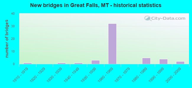
- New bridges - historical statistics
- 11910-1919
- 11930-1939
- 11940-1949
- 31950-1959
- 321960-1969
- 51980-1989
- 41990-1999
- 22000-2009
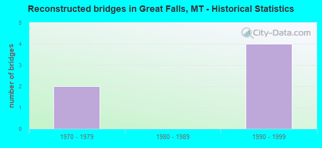
- Reconstructed bridges - Historical Statistics
- 21970-1979
- 01980-1989
- 41990-1999
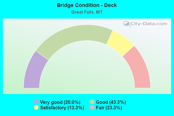
- Bridge Condition - Deck
- 20.0%Very good
- 43.3%Good
- 13.3%Satisfactory
- 23.3%Fair
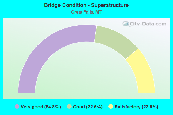
- Bridge Condition - Superstructure
- 54.8%Very good
- 22.6%Good
- 22.6%Satisfactory
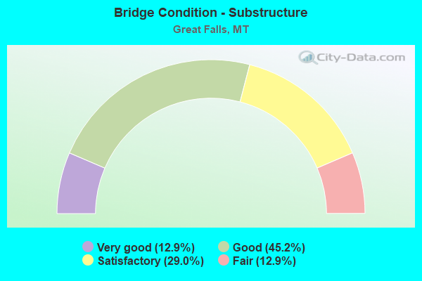
- Bridge Condition - Substructure
- 12.9%Very good
- 45.2%Good
- 29.0%Satisfactory
- 12.9%Fair
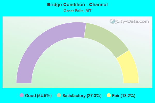
- Bridge Condition - Channel
- 54.5%Good
- 27.3%Satisfactory
- 18.2%Fair
Find on map >> Show street view
Structure Number: U05210000+01602, Location: GREAT FALLS-CENTRAL AVE W (Lat: 47.507889, Lng: -111.340742), Route carried "under" structure: ServiceCity street 72517, Year Built: 1967, Structure Length: 0. m, Average Daily Traffic: 653 (year 2020), Truck Traffic: 3%, Features Intersected: GALT AVE-RR, Facility Carried by Structure: CENTRAL AVE W
Minimum Vertical Clearance: 5.08m (16.67ft), Kilometerpoint: 0.015, Lanes on structure: 2, Lanes under structure: 2, Material/Design: Steel continuous, Design/Construction: Stringer/Multi-beam, Length of Maximum Span: 39.0m (128.0ft)
Find on map >> Show street view
Structure Number: U05212000+05881, Location: 1M SW GREAT FALLS (Lat: 47.472319, Lng: -111.360983), Route carried "under" structure: Interstate 15, Year Built: 1967, Structure Length: 0. m, Average Daily Traffic: 5,939 (year 2020), Truck Traffic: 13%, Features Intersected: INT GORE HILL-I 15, Facility Carried by Structure: AIRPORT DR
Minimum Vertical Clearance: 5.23m (17.16ft), Kilometerpoint: 446.226, Lanes on structure: 2, Lanes under structure: 4, Material/Design: Prestressed concrete, Design/Construction: Stringer/Multi-beam, Length of Maximum Span: 18.7m (61.4ft)