Bridge Statistics for Greenville, Alabama (AL)
Condition, Traffic, Stress, Structural Evaluation, Project Costs
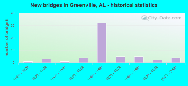
- New bridges - historical statistics
- 11920-1929
- 31930-1939
- 11940-1949
- 41950-1959
- 321960-1969
- 51970-1979
- 51980-1989
- 21990-1999
- 42000-2009

- Reconstructed bridges - Historical Statistics
- 11970-1979
- 11980-1989


- Bridge Condition - Deck
- 7.1%Very good
- 14.3%Good
- 42.9%Satisfactory
- 35.7%Fair

- Bridge Condition - Superstructure
- 3.6%Very good
- 28.6%Good
- 32.1%Satisfactory
- 32.1%Fair
- 3.6%Poor

- Bridge Condition - Substructure
- 7.1%Very good
- 21.4%Good
- 57.1%Satisfactory
- 14.3%Fair

- Bridge Condition - Channel
- 22.2%Very good
- 33.3%Good
- 38.9%Satisfactory
- 5.6%Fair

- Bridge Condition - Culverts
- 16.7%Good
- 72.2%Satisfactory
- 11.1%Fair
Find on map >> Show street view
Structure Number: 18312, Location: MASHVILLE (Lat: 31.809850, Lng: -86.541533), Route carried "on" structure: County highway 56, Year Built: 2002, Status: Open, Structure Length: 3.11m (10.20ft), Average Daily Traffic: 82 (year 2018), Truck Traffic: 20%, Average Future Daily Traffic: 190 (year 2040), Design Load: HS 20, Features Intersected: FORK OF FOUR MILE BRANCH, Facility Carried by Structure: CR. 43
Minimum Vertical Clearance: 30+ m (98+ ft), Kilometerpoint: 0.000, Lanes on structure: 2, Owner: County Highway Agency, Approaching Roadway Width: 6.7m (22.0ft), Material/Design: Concrete, Design/Construction: Channel Beam, Number Of Spans In Main Unit: 3, Length of Maximum Span: 10.4m (34.1ft), Curb-To-Curb Width: 8.5m (27.9ft), Out-to-Out Width: 9.3m (30.5ft)
Condition: Deck: Very good, Superstructure: Good, Substructure: Very good, Channel: Very good, Operating Rating: 73.7 metric tons, Method Used To Determine Operating Rating: Load Factor (LF), Inventory Rating: 44.2 metric tons, Method Used To Determine Inventory Rating: Load Factor (LF), Structural Evaluation: Better than present minimum criteria, Deck Geometry: Better than present minimum criteria, Waterway Adequacy: Superior to present desirable criteria, Approach Roadway Alignment: Equal to present desirable criteria, Length Of Structure Improvement: 3.96m (12.99ft), Designated Inspection Frequency: Every 24 months, Inspection Date: October 2020, Bridge Improvement Cost: $815,000, Roadway Improvement Cost: $82,000, Total Project Cost: $897,000 ( Estimate for 2022), Deck Structure Type: Concrete Precast Panels
Find on map >> Show street view
Structure Number: 18766, Location: 1.5 MI. E. MASHVILLE ?? (Lat: 31.816667, Lng: -86.600000), Route carried "on" structure: County highway 65, Year Built: 2004, Status: Open, Structure Length: 2.93m (9.61ft), Average Daily Traffic: 224 (year 2018), Truck Traffic: 26%, Average Future Daily Traffic: 340 (year 2040), Design Load: HS 20, Features Intersected: FOUR MILE MILL BRANCH
Minimum Vertical Clearance: 30+ m (98+ ft), Kilometerpoint: 0.000, Lanes on structure: 2, Owner: County Highway Agency, Approaching Roadway Width: 6.1m (20.0ft), Skew: 3 degrees, Material/Design: Concrete, Design/Construction: Channel Beam, Number Of Spans In Main Unit: 3, Length of Maximum Span: 9.8m (32.2ft), Curb-To-Curb Width: 8.5m (27.9ft), Out-to-Out Width: 9.3m (30.5ft)
Condition: Deck: Very good, Superstructure: Very good, Substructure: Very good, Channel: Very good, Operating Rating: 78.7 metric tons, Method Used To Determine Operating Rating: Load Factor (LF), Inventory Rating: 47.2 metric tons, Method Used To Determine Inventory Rating: Load Factor (LF), Structural Evaluation: Equal to present desirable criteria, Deck Geometry: Equal to present minimum criteria, Waterway Adequacy: Superior to present desirable criteria, Approach Roadway Alignment: Equal to present desirable criteria, Length Of Structure Improvement: 3.83m (12.57ft), Designated Inspection Frequency: Every 24 months, Inspection Date: March 2020, Bridge Improvement Cost: $789,000, Roadway Improvement Cost: $79,000, Total Project Cost: $868,000 ( Estimate for 2022), Deck Structure Type: Concrete Precast Panels
Find on map >> Show street view
Structure Number: 18782, Location: PERSIMMON CRK * I-65 (Lat: 31.868700, Lng: -86.622200), Route carried "on" structure: County highway 41, Year Built: 1968, Status: Open, Structure Length: 1.31m (4.30ft), Average Daily Traffic: 953 (year 2014), Truck Traffic: 1%, Average Future Daily Traffic: 1,492 (year 2034), Design Load: HS 20, Features Intersected: PERSIMMON CREEK
Minimum Vertical Clearance: 5.18m (16.99ft), Kilometerpoint: 2.414, Lanes on structure: 2, Owner: State Highway Agency, Approaching Roadway Width: 7.9m (25.9ft), Skew: 4 degrees, Material/Design: Concrete continuous, Design/Construction: Culvert, Number Of Spans In Main Unit: 4, Length of Maximum Span: 3.0m (9.8ft), Out-to-Out Width: 11.0m (36.1ft)
Condition: Channel: Satisfactory, Culverts: Satisfactory, Operating Rating: 88.9 metric tons, Method Used To Determine Operating Rating: Load Factor (LF), Inventory Rating: 72.8 metric tons, Method Used To Determine Inventory Rating: Load Factor (LF), Structural Evaluation: Equal to present minimum criteria, Waterway Adequacy: Superior to present desirable criteria, Approach Roadway Alignment: Better than present minimum criteria, Length Of Structure Improvement: 1.98m (6.50ft), Designated Inspection Frequency: Every 24 months, Underwater Inspection Frequency: Every 24 months, Inspection Date: October 2021, Underwater Inspection Date: October 2021, Bridge Improvement Cost: $493,000, Roadway Improvement Cost: $49,000, Total Project Cost: $542,000 ( Estimate for 2022)
Find on map >> Show street view
Structure Number: 21581, Location: 1100' from sch highlands (Lat: 31.817861, Lng: -86.629667), Route carried "on" structure: State lands road , Year Built: 1980, Status: Open, Structure Length: 0.73m (2.40ft), Average Daily Traffic: 500 (year 2020), Truck Traffic: 1%, Average Future Daily Traffic: 520 (year 2040), Design Load: HS 20, Features Intersected: Branch, Facility Carried by Structure: Government Street
Minimum Vertical Clearance: 30+ m (98+ ft), Kilometerpoint: 0.507, Lanes on structure: 2, Owner: City or Municipal Highway Agency, Approaching Roadway Width: 7.9m (25.9ft), Skew: 1 degrees, Material/Design: Concrete, Design/Construction: Culvert, Number Of Spans In Main Unit: 2, Length of Maximum Span: 3.0m (9.8ft)
Condition: Channel: Good, Culverts: Satisfactory, Operating Rating: 56.7 metric tons, Method Used To Determine Operating Rating: Load Factor (LF), Inventory Rating: 33.0 metric tons, Method Used To Determine Inventory Rating: Load Factor (LF), Structural Evaluation: Equal to present minimum criteria, Waterway Adequacy: Better than present minimum criteria, Approach Roadway Alignment: Better than present minimum criteria, Length Of Structure Improvement: 1.38m (4.53ft), Designated Inspection Frequency: Every 24 months, Inspection Date: May 2020, Bridge Improvement Cost: $389,000, Roadway Improvement Cost: $39,000, Total Project Cost: $428,000 ( Estimate for 2022)
Find on map >> Show street view
Structure Number: 21582, Location: 800' from Sch Highlands (Lat: 31.816889, Lng: -86.625139), Route carried "on" structure: State lands road 3, Year Built: 1980, Status: Open, Structure Length: 0.94m (3.08ft), Average Daily Traffic: 500 (year 2020), Truck Traffic: 1%, Average Future Daily Traffic: 520 (year 2040), Design Load: HS 20, Features Intersected: Branch, Facility Carried by Structure: Ogelsby Street
Minimum Vertical Clearance: 30+ m (98+ ft), Kilometerpoint: 0.805, Lanes on structure: 2, Owner: City or Municipal Highway Agency, Approaching Roadway Width: 7.9m (25.9ft), Material/Design: Concrete, Design/Construction: Culvert, Number Of Spans In Main Unit: 3, Length of Maximum Span: 3.0m (9.8ft)
Condition: Channel: Satisfactory, Culverts: Satisfactory, Operating Rating: 60.8 metric tons, Method Used To Determine Operating Rating: Load Factor (LF), Inventory Rating: 36.4 metric tons, Method Used To Determine Inventory Rating: Load Factor (LF), Structural Evaluation: Equal to present minimum criteria, Waterway Adequacy: Better than present minimum criteria, Approach Roadway Alignment: Better than present minimum criteria, Length Of Structure Improvement: 1.61m (5.28ft), Designated Inspection Frequency: Every 24 months, Inspection Date: May 2020, Bridge Improvement Cost: $401,000, Roadway Improvement Cost: $40,000, Total Project Cost: $441,000 ( Estimate for 2022)
Find on map >> Show street view
Structure Number: 272, Location: GRNVILLE-.2MI E OF AL 185 (Lat: 31.828333, Lng: -86.628333), Route carried "under" structure: State highway 10, Year Built: 1925, Structure Length: 0. m, Average Daily Traffic: 6,120 (year 2013), Truck Traffic: 4%, Features Intersected: AL 10, Facility Carried by Structure: CSX RR
Minimum Vertical Clearance: 3.00m (9.84ft), Kilometerpoint: 198.213, Lanes under structure: 2, Material/Design: Concrete, Design/Construction: Slab, Length of Maximum Span: 4.9m (16.1ft)
Find on map >> Show street view
Structure Number: 9256, Location: 1.4 MI S OF AL 10 (Lat: 31.804106, Lng: -86.669539), Route carried "under" structure: Interstate 65, Year Built: 1967, Structure Length: 0. m, Average Daily Traffic: 25,990 (year 2013), Truck Traffic: 27%, Features Intersected: I65, Facility Carried by Structure: CO RD 22
Minimum Vertical Clearance: 5.08m (16.67ft), Kilometerpoint: 203.297, Lanes on structure: 2, Lanes under structure: 4, Material/Design: Steel, Design/Construction: Stringer/Multi-beam, Length of Maximum Span: 24.4m (80.1ft)
Find on map >> Show street view
Structure Number: 9259, Location: AL 10 AND I65 INTERCHANGE (Lat: 31.822925, Lng: -86.665031), Route carried "under" structure: State highway 10, Year Built: 1967, Structure Length: 0. m, Average Daily Traffic: 4,370 (year 2013), Truck Traffic: 7%, Features Intersected: AL 10, Facility Carried by Structure: I65 SBL
Minimum Vertical Clearance: 5.15m (16.90ft), Kilometerpoint: 194.520, Lanes on structure: 2, Lanes under structure: 2, Material/Design: Steel, Design/Construction: Stringer/Multi-beam, Length of Maximum Span: 24.7m (81.0ft)
Find on map >> Show street view
Structure Number: 926, Location: AL 10 AND I65 INTERCHANGE (Lat: 31.823056, Lng: -86.663856), Route carried "under" structure: State highway 10, Year Built: 1967, Structure Length: 0. m, Average Daily Traffic: 4,370 (year 2013), Truck Traffic: 7%, Features Intersected: AL 10, Facility Carried by Structure: I65 NBL
Minimum Vertical Clearance: 5.28m (17.32ft), Kilometerpoint: 194.620, Lanes on structure: 2, Lanes under structure: 2, Material/Design: Steel, Design/Construction: Stringer/Multi-beam, Length of Maximum Span: 24.7m (81.0ft)
Find on map >> Show street view
Structure Number: 9521, Location: CO 42 AND I65 (Lat: 31.845722, Lng: -86.647275), Route carried "under" structure: Interstate 65, Year Built: 1968, Structure Length: 0. m, Average Daily Traffic: 29,320 (year 2013), Truck Traffic: 25%, Features Intersected: I65, Facility Carried by Structure: CO 42
Minimum Vertical Clearance: 5.03m (16.50ft), Kilometerpoint: 208.452, Lanes on structure: 2, Lanes under structure: 4, Material/Design: Concrete continuous, Design/Construction: Tee Beam, Length of Maximum Span: 29.3m (96.1ft)
Find on map >> Show street view
Structure Number: 9522, Location: 1.6 MI N OF AL 185 (Lat: 31.868447, Lng: -86.622233), Route carried "under" structure: County highway 41, Year Built: 1968, Structure Length: 0. m, Average Daily Traffic: 928 (year 2003), Truck Traffic: 1%, Features Intersected: CO RD 41 * PERSIMMON CRK, Facility Carried by Structure: I65 SBL
Minimum Vertical Clearance: 5.28m (17.32ft), Kilometerpoint: 2.699, Lanes on structure: 2, Lanes under structure: 2, Material/Design: Steel, Design/Construction: Stringer/Multi-beam, Length of Maximum Span: 21.9m (71.9ft)
Find on map >> Show street view
Structure Number: 9523, Location: 1.6 MI N OF AL 185 (Lat: 31.868331, Lng: -86.621989), Route carried "under" structure: County highway 41, Year Built: 1968, Structure Length: 0. m, Average Daily Traffic: 640 (year 2003), Truck Traffic: 1%, Features Intersected: CO RD 41 * PERSIMMON CRK, Facility Carried by Structure: I65 NBL
Minimum Vertical Clearance: 5.11m (16.77ft), Kilometerpoint: 2.260, Lanes on structure: 2, Lanes under structure: 2, Material/Design: Steel, Design/Construction: Stringer/Multi-beam, Length of Maximum Span: 21.3m (69.9ft)
Find on map >> Show street view
Structure Number: 9526, Location: I65 OVER CO 45 (Lat: 31.894000, Lng: -86.602244), Route carried "under" structure: County highway 45, Year Built: 1968, Structure Length: 0. m, Average Daily Traffic: 646 (year 2003), Truck Traffic: 1%, Features Intersected: CO 45, Facility Carried by Structure: I65 SBL
Minimum Vertical Clearance: 4.88m (16.01ft), Kilometerpoint: 50.239, Lanes on structure: 2, Lanes under structure: 2, Material/Design: Steel, Design/Construction: Stringer/Multi-beam, Length of Maximum Span: 25.3m (83.0ft)
Find on map >> Show street view
Structure Number: 9527, Location: I65 OVER CO 45 (Lat: 31.893803, Lng: -86.602061), Route carried "under" structure: County highway 45, Year Built: 1968, Structure Length: 0. m, Average Daily Traffic: 646 (year 2003), Truck Traffic: 1%, Features Intersected: CO 45, Facility Carried by Structure: I65 NBL
Minimum Vertical Clearance: 4.88m (16.01ft), Kilometerpoint: 50.239, Lanes on structure: 2, Lanes under structure: 2, Material/Design: Steel, Design/Construction: Stringer/Multi-beam, Length of Maximum Span: 25.3m (83.0ft)
Find on map >> Show street view
Structure Number: 13508, Location: CO RD 30 * I65 (Lat: 31.772956, Lng: -86.692067), Route carried "under" structure: Interstate 65, Year Built: 1967, Structure Length: 0. m, Average Daily Traffic: 25,990 (year 2013), Truck Traffic: 27%, Features Intersected: I65, Facility Carried by Structure: CO RD 30
Minimum Vertical Clearance: 5.38m (17.65ft), Kilometerpoint: 199.145, Lanes on structure: 2, Lanes under structure: 4, Material/Design: Steel continuous, Design/Construction: Stringer/Multi-beam, Length of Maximum Span: 21.9m (71.9ft)
Find on map >> Show street view
Structure Number: 16642, Location: I-65 * AL 185 INT (Lat: 31.850161, Lng: -86.640761), Route carried "under" structure: Interstate 65, Year Built: 1996, Structure Length: 0. m, Average Daily Traffic: 29,320 (year 2013), Truck Traffic: 25%, Features Intersected: I-65, Facility Carried by Structure: AL 185
Minimum Vertical Clearance: 5.33m (17.49ft), Kilometerpoint: 209.289, Lanes on structure: 5, Lanes under structure: 4, Material/Design: Prestressed concrete, Design/Construction: Stringer/Multi-beam, Length of Maximum Span: 29.0m (95.1ft)