Bridge Statistics for Grinnell, Iowa (IA)
Condition, Traffic, Stress, Structural Evaluation, Project Costs
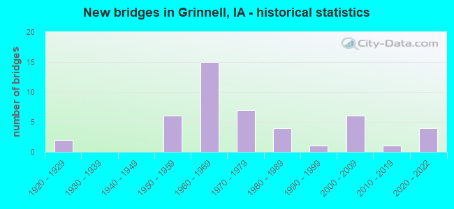
- New bridges - historical statistics
- 21920-1929
- 61950-1959
- 151960-1969
- 71970-1979
- 41980-1989
- 11990-1999
- 62000-2009
- 12010-2019
- 42020-2022
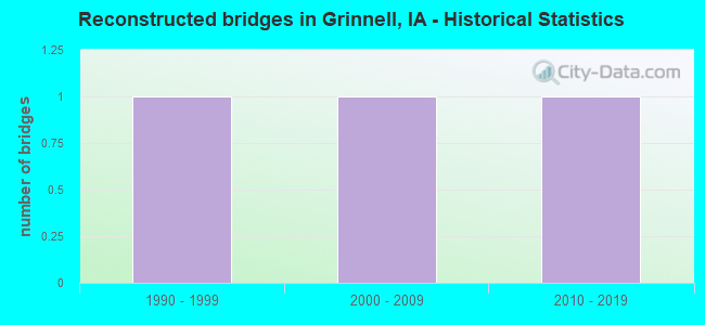
- Reconstructed bridges - Historical Statistics
- 11990-1999
- 12000-2009
- 12010-2019
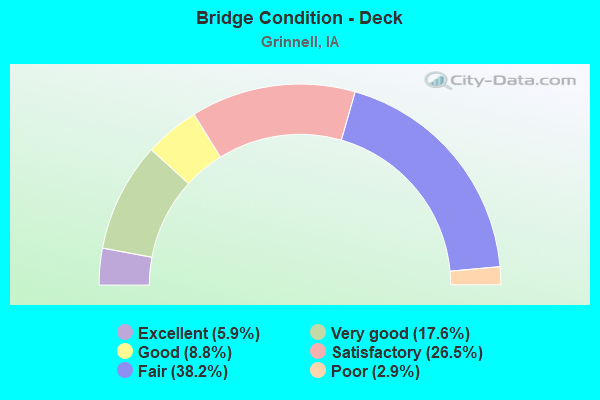
- Bridge Condition - Deck
- 5.9%Excellent
- 17.6%Very good
- 8.8%Good
- 26.5%Satisfactory
- 38.2%Fair
- 2.9%Poor
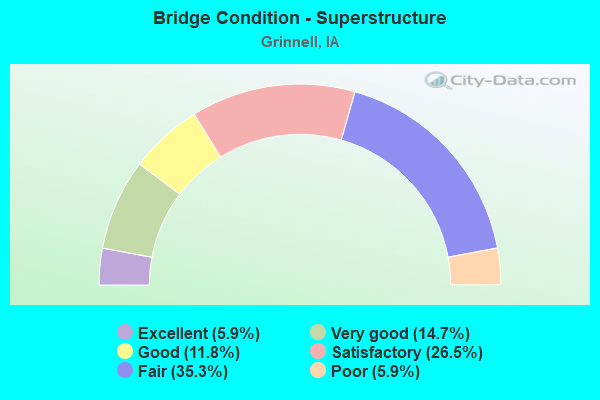
- Bridge Condition - Superstructure
- 5.9%Excellent
- 14.7%Very good
- 11.8%Good
- 26.5%Satisfactory
- 35.3%Fair
- 5.9%Poor
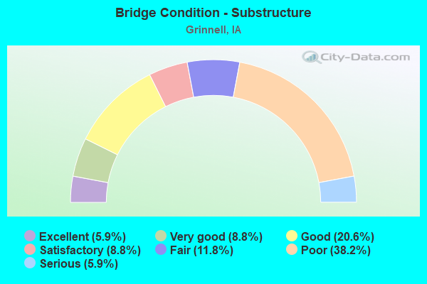
- Bridge Condition - Substructure
- 5.9%Excellent
- 8.8%Very good
- 20.6%Good
- 8.8%Satisfactory
- 11.8%Fair
- 38.2%Poor
- 5.9%Serious
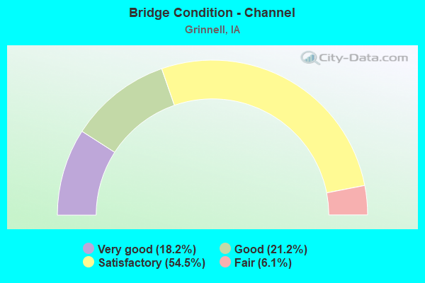
- Bridge Condition - Channel
- 18.2%Very good
- 21.2%Good
- 54.5%Satisfactory
- 6.1%Fair
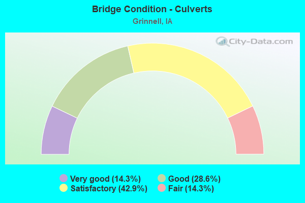
- Bridge Condition - Culverts
- 14.3%Very good
- 28.6%Good
- 42.9%Satisfactory
- 14.3%Fair
Find on map >> Show street view
Structure Number: 4605, Location: AT JCT. IOWA 146 (Lat: 41.696144, Lng: -92.727486), Route carried "under" structure: State highway 146, Year Built: 1962, Structure Length: 0. m, Average Daily Traffic: 3,050 (year 2020), Truck Traffic: 8%, Features Intersected: IOWA 146, Facility Carried by Structure: EB I 80
Minimum Vertical Clearance: 30+ m (98+ ft), Kilometerpoint: 29.754, Lanes on structure: 2, Lanes under structure: 4, Material/Design: Prestressed concrete, Design/Construction: Stringer/Multi-beam, Length of Maximum Span: 19.8m (65.0ft)
Find on map >> Show street view
Structure Number: 46051, Location: AT JCT. IOWA 146 (Lat: 41.695978, Lng: -92.727458), Route carried "under" structure: State highway 146, Year Built: 2020, Structure Length: 0. m, Average Daily Traffic: 3,050 (year 2020), Truck Traffic: 8%, Features Intersected: IA 146, Facility Carried by Structure: I 80 EB
Minimum Vertical Clearance: 30+ m (98+ ft), Kilometerpoint: 29.731, Lanes on structure: 3, Lanes under structure: 6, Material/Design: Prestressed concrete, Design/Construction: Stringer/Multi-beam, Length of Maximum Span: 39.9m (130.9ft)
Find on map >> Show street view
Structure Number: 4606, Location: AT JCT. IOWA 146 (Lat: 41.696328, Lng: -92.726703), Route carried "under" structure: State highway 146, Year Built: 1962, Structure Length: 0. m, Average Daily Traffic: 3,050 (year 2020), Truck Traffic: 8%, Features Intersected: IOWA 146, Facility Carried by Structure: WB I 80
Minimum Vertical Clearance: 30+ m (98+ ft), Kilometerpoint: 29.778, Lanes on structure: 2, Lanes under structure: 5, Material/Design: Prestressed concrete, Design/Construction: Stringer/Multi-beam, Length of Maximum Span: 19.8m (65.0ft)
Find on map >> Show street view
Structure Number: 461, Location: 2.1 mi. E of Jct. IA 146 (Lat: 41.695303, Lng: -92.688700), Route carried "under" structure: County highway , Year Built: 1963, Structure Length: 0. m, Average Daily Traffic: 20 (year 2018), Features Intersected: 50TH STREET, Facility Carried by Structure: EB I-80
Minimum Vertical Clearance: 30+ m (98+ ft), Kilometerpoint: 12.505, Lanes on structure: 2, Lanes under structure: 2, Material/Design: Concrete continuous, Design/Construction: Slab, Length of Maximum Span: 13.4m (44.0ft)
Find on map >> Show street view
Structure Number: 4611, Location: 2.1 mi. E of Jct IA 146 (Lat: 41.695522, Lng: -92.688286), Route carried "under" structure: County highway , Year Built: 1963, Structure Length: 0. m, Average Daily Traffic: 20 (year 2018), Features Intersected: 50TH STREET, Facility Carried by Structure: WB I-80
Minimum Vertical Clearance: 30+ m (98+ ft), Kilometerpoint: 12.529, Lanes on structure: 2, Lanes under structure: 2, Material/Design: Concrete continuous, Design/Construction: Slab, Length of Maximum Span: 13.4m (44.0ft)