Bridge Statistics for Gulfport, Mississippi (MS)
Condition, Traffic, Stress, Structural Evaluation, Project Costs
- National Bridge Inventory (NBI) Statistics
- 89Number of bridges
- 2,723ft / 830mTotal length
- $3,703,153,000Total costs
- 1,408,406Total average daily traffic
- 160,055Total average daily truck traffic
- National Bridge Inventory (NBI) Registered Bridges for Gulfport
- No street view available for this location
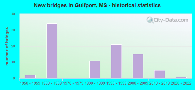
- New bridges - historical statistics
- 21950-1959
- 341960-1969
- 111980-1989
- 211990-1999
- 152000-2009
- 52010-2019
- 12020-2022

- Reconstructed bridges - Historical Statistics
- 11980-1989
- 01990-1999
- 162000-2009


- Bridge Condition - Deck
- 5.6%Very good
- 63.9%Good
- 23.6%Satisfactory
- 5.6%Fair
- 1.4%Poor

- Bridge Condition - Superstructure
- 30.6%Very good
- 48.6%Good
- 13.9%Satisfactory
- 5.6%Fair
- 1.4%Poor

- Bridge Condition - Substructure
- 38.9%Very good
- 36.1%Good
- 13.9%Satisfactory
- 9.7%Fair
- 1.4%Poor

- Bridge Condition - Channel
- 9.2%Excellent
- 18.5%Very good
- 38.5%Good
- 21.5%Satisfactory
- 10.8%Fair
- 1.5%Poor

- Bridge Condition - Culverts
- 60.0%Very good
- 20.0%Good
- 20.0%Fair
Find on map >> Show street view
Structure Number: 11000100240396B, Location: 3.8 MI E US 49 (Lat: 30.444261, Lng: -89.031069), Route carried "under" structure: State highway 605, Year Built: 1969, Structure Length: 0. m, Average Daily Traffic: 15,500 (year 2018), Truck Traffic: 10%, Features Intersected: SR 605, Facility Carried by Structure: I 10
Minimum Vertical Clearance: 5.19m (17.03ft), Kilometerpoint: 7.009, Lanes on structure: 3, Lanes under structure: 6, Material/Design: Prestressed concrete, Design/Construction: Stringer/Multi-beam, Length of Maximum Span: 24.4m (80.1ft)
Find on map >> Show street view
Structure Number: 21000900240336, Location: 0.6 MI W US 49 (Lat: 30.362900, Lng: -89.101669), Route carried "under" structure: US 90, Year Built: 1999, Structure Length: 0. m, Average Daily Traffic: 31,500 (year 2018), Truck Traffic: 3%, Features Intersected: US 90, Facility Carried by Structure: OVERHEAD WALKWAY
Minimum Vertical Clearance: 4.90m (16.08ft), Kilometerpoint: 25.814, Lanes under structure: 3, Material/Design: Steel, Design/Construction: Stringer/Multi-beam, Length of Maximum Span: 30.5m (100.1ft)
Find on map >> Show street view
Structure Number: 21000900240336, Location: 0.6 MI W US 49 (Lat: 30.362611, Lng: -89.101461), Route carried "under" structure: US 90, Year Built: 1999, Structure Length: 0. m, Average Daily Traffic: 31,500 (year 2018), Truck Traffic: 3%, Features Intersected: US 90, Facility Carried by Structure: OVERHEAD WALKWAY
Minimum Vertical Clearance: 5.07m (16.63ft), Kilometerpoint: 19.991, Lanes under structure: 4, Material/Design: Steel, Design/Construction: Stringer/Multi-beam, Length of Maximum Span: 30.5m (100.1ft)
Find on map >> Show street view
Structure Number: 210009002404, Location: 0.6 MI E SR 605 (Lat: 30.384600, Lng: -89.016169), Route carried "under" structure: US 90, Year Built: 2013, Structure Length: 0. m, Average Daily Traffic: 12,000 (year 2018), Truck Traffic: 8%, Features Intersected: US 90, Facility Carried by Structure: OVERHEAD WALKWAY
Minimum Vertical Clearance: 8.21m (26.94ft), Kilometerpoint: 0.000, Lanes under structure: 2, Material/Design: Steel, Design/Construction: Truss - Thru, Length of Maximum Span: 51.2m (168.0ft)
Find on map >> Show street view
Structure Number: 210009002404, Location: 0.6 MI E SR 605 (Lat: 30.384600, Lng: -89.016169), Route carried "under" structure: US 90, Year Built: 2013, Structure Length: 0. m, Average Daily Traffic: 12,000 (year 2018), Truck Traffic: 8%, Features Intersected: US 90, Facility Carried by Structure: OVERHEAD WALKWAY
Minimum Vertical Clearance: 8.48m (27.82ft), Kilometerpoint: 0.000, Lanes under structure: 2, Material/Design: Steel, Design/Construction: Truss - Thru, Length of Maximum Span: 51.2m (168.0ft)