Bridge Statistics for Haltom City, Texas (TX)
Condition, Traffic, Stress, Structural Evaluation, Project Costs
- National Bridge Inventory (NBI) Statistics
- 53Number of bridges
- 1,020ft / 311mTotal length
- $400,000Total costs
- 1,667,973Total average daily traffic
- 88,106Total average daily truck traffic
- National Bridge Inventory (NBI) Registered Bridges for Haltom City
- No street view available for this location
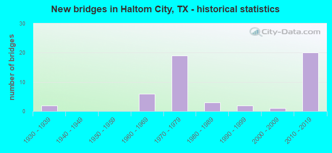
- New bridges - historical statistics
- 21930-1939
- 61960-1969
- 191970-1979
- 31980-1989
- 21990-1999
- 12000-2009
- 202010-2019


- Bridge Condition - Deck
- 9.1%Very good
- 66.7%Good
- 18.2%Satisfactory
- 6.1%Fair

- Bridge Condition - Superstructure
- 36.4%Very good
- 36.4%Good
- 27.3%Satisfactory

- Bridge Condition - Substructure
- 15.2%Very good
- 66.7%Good
- 18.2%Satisfactory

- Bridge Condition - Channel
- 26.9%Very good
- 38.5%Good
- 34.6%Satisfactory

- Bridge Condition - Culverts
- 40.0%Good
- 60.0%Satisfactory
Find on map >> Show street view
Structure Number: 22200000814484, Location: IH-820 WB EXIT @ WB GP LN (Lat: 32.840019, Lng: -97.259111), Route carried "on" structure: Other road 820, Year Built: 2013, Status: Open, Structure Length: 15.24m (50.00ft), Average Daily Traffic: 9,900 (year 2013), Truck Traffic: 7%, Average Future Daily Traffic: 14,400 (year 2033), Design Load: HL 93, Features Intersected: IH-820 WB GP LANES
Minimum Vertical Clearance: 30+ m (98+ ft), Kilometerpoint: 0.000, Lanes on structure: 1, Lanes under structure: 2, Toll: On toll road, Owner: State Highway Agency, Maintenance Responsibility: Local Toll Authority, Approaching Roadway Width: 7.9m (25.9ft), Material/Design: Prestressed concrete, Design/Construction: Stringer/Multi-beam, Number Of Spans In Main Unit: 5, Length of Maximum Span: 30.5m (100.1ft), Curb-To-Curb Width: 7.9m (25.9ft), Out-to-Out Width: 8.5m (27.9ft)
Condition: Deck: Good, Superstructure: Very good, Substructure: Good, Operating Rating: 54.4 metric tons, Method Used To Determine Operating Rating: Assigned ratings based on Load and Resistance Factor Design (LRFD) reported in metric tons, Inventory Rating: 32.7 metric tons, Method Used To Determine Inventory Rating: Assigned ratings based on Load and Resistance Factor Design (LRFD) reported in metric tons, Structural Evaluation: Better than present minimum criteria, Deck Geometry: High priority of corrective action, Underclear: High priority of corrective action, Approach Roadway Alignment: High priority of corrective action, Designated Inspection Frequency: Every 24 months, Inspection Date: May 2020, Deck Structure Type: Concrete Precast Panels
Find on map >> Show street view
Structure Number: 22200000814485, Location: 200' E. OF US 377 (Lat: 32.839139, Lng: -97.261886), Route carried "on" structure: ServiceInterstate 820, Year Built: 2013, Status: Open, Structure Length: 22.86m (75.00ft), Average Daily Traffic: 18,400 (year 2010), Truck Traffic: 7%, Average Future Daily Traffic: 27,100 (year 2030), Design Load: HL 93, Features Intersected: BIG FOSSIL CREEK
Minimum Vertical Clearance: 30+ m (98+ ft), Kilometerpoint: 0.000, Lanes on structure: 1, Owner: State Highway Agency, Maintenance Responsibility: Local Toll Authority, Approaching Roadway Width: 7.9m (25.9ft), Material/Design: Prestressed concrete, Design/Construction: Stringer/Multi-beam, Number Of Spans In Main Unit: 7, Length of Maximum Span: 33.5m (109.9ft), Curb-To-Curb Width: 7.9m (25.9ft), Out-to-Out Width: 8.5m (27.9ft)
Condition: Deck: Good, Superstructure: Very good, Substructure: Good, Channel: Good, Operating Rating: 54.4 metric tons, Method Used To Determine Operating Rating: Assigned ratings based on Load and Resistance Factor Design (LRFD) reported in metric tons, Inventory Rating: 32.7 metric tons, Method Used To Determine Inventory Rating: Assigned ratings based on Load and Resistance Factor Design (LRFD) reported in metric tons, Structural Evaluation: Better than present minimum criteria, Deck Geometry: High priority of corrective action, Waterway Adequacy: Superior to present desirable criteria, Approach Roadway Alignment: Equal to present desirable criteria, Designated Inspection Frequency: Every 24 months, Inspection Date: May 2020, Deck Structure Type: Concrete Precast Panels
Find on map >> Show street view
Structure Number: 22200000814486, Location: IH820 EB ON RMP ML @ 820 (Lat: 32.839294, Lng: -97.261883), Route carried "on" structure: Other road 820, Year Built: 2013, Status: Open, Structure Length: 19.96m (65.49ft), Average Daily Traffic: 7,300 (year 2013), Truck Traffic: 7%, Average Future Daily Traffic: 10,500 (year 2033), Design Load: HL 93, Features Intersected: IH-820 EBGP & BIG FOSSIL
Minimum Vertical Clearance: 30+ m (98+ ft), Kilometerpoint: 0.000, Lanes on structure: 1, Lanes under structure: 2, Toll: On toll road, Owner: State Highway Agency, Maintenance Responsibility: Local Toll Authority, Approaching Roadway Width: 7.9m (25.9ft), Material/Design: Prestressed concrete, Design/Construction: Stringer/Multi-beam, Number Of Spans In Main Unit: 6, Number Of Approach Spans: 1, Length of Maximum Span: 30.5m (100.1ft), Curb-To-Curb Width: 7.9m (25.9ft), Out-to-Out Width: 8.5m (27.9ft)
Condition: Deck: Good, Superstructure: Very good, Substructure: Good, Channel: Very good, Operating Rating: 54.4 metric tons, Method Used To Determine Operating Rating: Assigned ratings based on Load and Resistance Factor Design (LRFD) reported in metric tons, Inventory Rating: 32.7 metric tons, Method Used To Determine Inventory Rating: Assigned ratings based on Load and Resistance Factor Design (LRFD) reported in metric tons, Structural Evaluation: Better than present minimum criteria, Deck Geometry: High priority of corrective action, Underclear: High priority of corrective action, Waterway Adequacy: Equal to present desirable criteria, Approach Roadway Alignment: Equal to present desirable criteria, Designated Inspection Frequency: Every 24 months, Inspection Date: May 2020, Deck Structure Type: Concrete Precast Panels
Find on map >> Show street view
Structure Number: 22200000814498, Location: 0.42 MI. E. OF N. BEACH (Lat: 32.839333, Lng: -97.282833), Route carried "on" structure: Other road 820, Year Built: 2013, Status: Open, Structure Length: 22.74m (74.61ft), Average Daily Traffic: 2,310 (year 2010), Truck Traffic: 6%, Average Future Daily Traffic: 3,427 (year 2030), Design Load: HL 93, Features Intersected: IH-820 EB GP LANES
Minimum Vertical Clearance: 30+ m (98+ ft), Kilometerpoint: 0.000, Lanes on structure: 1, Lanes under structure: 2, Toll: On toll road, Owner: State Highway Agency, Maintenance Responsibility: Local Toll Authority, Approaching Roadway Width: 7.9m (25.9ft), Skew: 1 degrees, Material/Design: Prestressed concrete, Design/Construction: Stringer/Multi-beam, Number Of Spans In Main Unit: 7, Number Of Approach Spans: 1, Length of Maximum Span: 32.3m (106.0ft), Curb-To-Curb Width: 7.9m (25.9ft), Out-to-Out Width: 8.5m (27.9ft)
Condition: Deck: Very good, Superstructure: Very good, Substructure: Good, Operating Rating: 54.4 metric tons, Method Used To Determine Operating Rating: Assigned ratings based on Load and Resistance Factor Design (LRFD) reported in metric tons, Inventory Rating: 32.7 metric tons, Method Used To Determine Inventory Rating: Assigned ratings based on Load and Resistance Factor Design (LRFD) reported in metric tons, Structural Evaluation: Better than present minimum criteria, Deck Geometry: High priority of corrective action, Underclear: Meets minimum limits, Approach Roadway Alignment: Equal to present desirable criteria, Designated Inspection Frequency: Every 24 months, Inspection Date: May 2020, Deck Structure Type: Concrete Precast Panels
Find on map >> Show street view
Structure Number: 22200000814499, Location: 0.15 MI. W. OF HALTOM RD. (Lat: 32.839886, Lng: -97.279408), Route carried "on" structure: Other road 820, Year Built: 2013, Status: Open, Structure Length: 21.73m (71.29ft), Average Daily Traffic: 1,679 (year 2010), Truck Traffic: 6%, Average Future Daily Traffic: 2,519 (year 2030), Design Load: HL 93, Features Intersected: IH-820 WB GP LANES
Minimum Vertical Clearance: 30+ m (98+ ft), Kilometerpoint: 0.000, Lanes on structure: 1, Lanes under structure: 2, Toll: On toll road, Owner: State Highway Agency, Maintenance Responsibility: Local Toll Authority, Approaching Roadway Width: 7.9m (25.9ft), Skew: 9 degrees, Material/Design: Prestressed concrete, Design/Construction: Stringer/Multi-beam, Number Of Spans In Main Unit: 6, Length of Maximum Span: 38.4m (126.0ft), Curb-To-Curb Width: 7.9m (25.9ft), Out-to-Out Width: 8.5m (27.9ft)
Condition: Deck: Very good, Superstructure: Very good, Substructure: Good, Operating Rating: 54.4 metric tons, Method Used To Determine Operating Rating: Assigned ratings based on Load and Resistance Factor Design (LRFD) reported in metric tons, Inventory Rating: 32.7 metric tons, Method Used To Determine Inventory Rating: Assigned ratings based on Load and Resistance Factor Design (LRFD) reported in metric tons, Structural Evaluation: Better than present minimum criteria, Deck Geometry: Meets minimum limits, Underclear: High priority of corrective action, Approach Roadway Alignment: Equal to present desirable criteria, Designated Inspection Frequency: Every 24 months, Inspection Date: May 2020, Deck Structure Type: Concrete Precast Panels
Find on map >> Show street view
Structure Number: 222000008145, Location: 0.7 MI. W. of US 377 (Lat: 32.839825, Lng: -97.276908), Route carried "on" structure: City street 657, Year Built: 2013, Status: Open, Structure Length: 9.42m (30.91ft), Average Daily Traffic: 11,076 (year 2019), Average Future Daily Traffic: 25,500 (year 2030), Design Load: HL 93, Features Intersected: IH-820 GP & MANAGED LANE, Facility Carried by Structure: HALTOM ROAD
Minimum Vertical Clearance: 30+ m (98+ ft), Kilometerpoint: 0.000, Lanes on structure: 6, Lanes under structure: 14, Owner: State Highway Agency, Maintenance Responsibility: Local Toll Authority, Approaching Roadway Width: 20.1m (65.9ft), Skew: 20 degrees, Material/Design: Prestressed concrete, Design/Construction: Stringer/Multi-beam, Number Of Spans In Main Unit: 2, Number Of Approach Spans: 2, Length of Maximum Span: 32.0m (105.0ft), Curb or Sidewalk Widths: Left: 0.0m, Right: 3.0m (9.8ft), Curb-To-Curb Width: 28.7m (94.2ft), Out-to-Out Width: 34.6m (113.5ft)
Condition: Deck: Very good, Superstructure: Very good, Substructure: Good, Operating Rating: 54.4 metric tons, Method Used To Determine Operating Rating: Assigned ratings based on Load and Resistance Factor Design (LRFD) reported in metric tons, Inventory Rating: 32.7 metric tons, Method Used To Determine Inventory Rating: Assigned ratings based on Load and Resistance Factor Design (LRFD) reported in metric tons, Structural Evaluation: Better than present minimum criteria, Deck Geometry: Superior to present desirable criteria, Underclear: High priority of corrective action, Approach Roadway Alignment: Equal to present desirable criteria, Designated Inspection Frequency: Every 24 months, Inspection Date: May 2020, Deck Structure Type: Concrete Precast Panels
Find on map >> Show street view
Structure Number: 22200000814501, Location: 1.5 W. OF RUFE SNOW DR. (Lat: 32.839581, Lng: -97.264119), Route carried "on" structure: US 377, Year Built: 2013, Status: Open, Structure Length: 6.71m (22.01ft), Average Daily Traffic: 49,131 (year 2018), Truck Traffic: 7%, Average Future Daily Traffic: 51,500 (year 2030), Design Load: HL 93, Features Intersected: IH-820
Minimum Vertical Clearance: 30+ m (98+ ft), Kilometerpoint: 0.000, Lanes on structure: 5, Lanes under structure: 9, Owner: State Highway Agency, Maintenance Responsibility: Local Toll Authority, Approaching Roadway Width: 15.9m (52.2ft), Skew: 20 degrees, Material/Design: Prestressed concrete, Design/Construction: Stringer/Multi-beam, Number Of Spans In Main Unit: 2, Length of Maximum Span: 34.7m (113.8ft), Curb or Sidewalk Widths: Left: 0.0m, Right: 3.4m (11.2ft), Curb-To-Curb Width: 14.6m (47.9ft), Out-to-Out Width: 27.4m (89.9ft)
Condition: Deck: Good, Superstructure: Very good, Substructure: Good, Operating Rating: 54.4 metric tons, Method Used To Determine Operating Rating: Assigned ratings based on Load and Resistance Factor Design (LRFD) reported in metric tons, Inventory Rating: 32.7 metric tons, Method Used To Determine Inventory Rating: Assigned ratings based on Load and Resistance Factor Design (LRFD) reported in metric tons, Structural Evaluation: Better than present minimum criteria, Deck Geometry: High priority of replacement, Underclear: High priority of corrective action, Approach Roadway Alignment: Equal to present desirable criteria, Designated Inspection Frequency: Every 24 months, Inspection Date: May 2020, Deck Structure Type: Concrete Precast Panels
Find on map >> Show street view
Structure Number: 22200000814502, Location: 1.5 MI. W. OF RUFE SNOW (Lat: 32.839794, Lng: -97.263900), Route carried "on" structure: US 377, Year Built: 2013, Status: Open, Structure Length: 6.71m (22.01ft), Average Daily Traffic: 19,000 (year 2010), Truck Traffic: 7%, Average Future Daily Traffic: 28,700 (year 2030), Design Load: HL 93, Features Intersected: IH-820
Minimum Vertical Clearance: 30+ m (98+ ft), Kilometerpoint: 0.000, Lanes on structure: 4, Lanes under structure: 9, Owner: State Highway Agency, Maintenance Responsibility: Local Toll Authority, Approaching Roadway Width: 15.9m (52.2ft), Skew: 20 degrees, Material/Design: Prestressed concrete, Design/Construction: Stringer/Multi-beam, Number Of Spans In Main Unit: 2, Length of Maximum Span: 34.7m (113.8ft), Curb or Sidewalk Widths: Left: 2.0m (6.6ft), Right: 0.0m, Curb-To-Curb Width: 16.2m (53.1ft), Out-to-Out Width: 18.8m (61.7ft)
Condition: Deck: Good, Superstructure: Very good, Substructure: Very good, Operating Rating: 54.4 metric tons, Method Used To Determine Operating Rating: Assigned ratings based on Load and Resistance Factor Design (LRFD) reported in metric tons, Inventory Rating: 32.7 metric tons, Method Used To Determine Inventory Rating: Assigned ratings based on Load and Resistance Factor Design (LRFD) reported in metric tons, Structural Evaluation: Equal to present desirable criteria, Deck Geometry: Meets minimum limits, Underclear: High priority of corrective action, Approach Roadway Alignment: Equal to present desirable criteria, Designated Inspection Frequency: Every 24 months, Inspection Date: May 2020, Deck Structure Type: Concrete Precast Panels
Find on map >> Show street view
Structure Number: 22200000814503, Location: 0.1 MI. EAST OF US 377 (Lat: 32.840022, Lng: -97.260661), Route carried "on" structure: Interstate 820, Year Built: 2013, Status: Open, Structure Length: 10.06m (33.01ft), Average Daily Traffic: 57,581 (year 2019), Truck Traffic: 6%, Average Future Daily Traffic: 75,040 (year 2031), Design Load: HL 93, Features Intersected: BIG FOSSIL CREEK
Minimum Vertical Clearance: 30+ m (98+ ft), Kilometerpoint: 0.000, Lanes on structure: 2, Owner: State Highway Agency, Maintenance Responsibility: Local Toll Authority, Approaching Roadway Width: 11.6m (38.1ft), Skew: 4 degrees, Material/Design: Prestressed concrete, Design/Construction: Stringer/Multi-beam, Number Of Spans In Main Unit: 3, Length of Maximum Span: 33.5m (109.9ft), Curb-To-Curb Width: 11.6m (38.1ft), Out-to-Out Width: 12.2m (40.0ft)
Condition: Deck: Good, Superstructure: Good, Substructure: Very good, Channel: Good, Operating Rating: 54.4 metric tons, Method Used To Determine Operating Rating: Assigned ratings based on Load and Resistance Factor Design (LRFD) reported in metric tons, Inventory Rating: 32.7 metric tons, Method Used To Determine Inventory Rating: Assigned ratings based on Load and Resistance Factor Design (LRFD) reported in metric tons, Structural Evaluation: Better than present minimum criteria, Deck Geometry: Equal to present minimum criteria, Waterway Adequacy: Superior to present desirable criteria, Approach Roadway Alignment: Equal to present desirable criteria, Designated Inspection Frequency: Every 24 months, Inspection Date: May 2020, Deck Structure Type: Concrete Precast Panels
Find on map >> Show street view
Structure Number: 22200000814504, Location: IH 820 ML @ BIG FOSSIL CK (Lat: 32.839733, Lng: -97.261569), Route carried "on" structure: Other road 820, Year Built: 2014, Status: Open, Structure Length: 10.06m (33.01ft), Average Daily Traffic: 48,000 (year 2013), Truck Traffic: 6%, Average Future Daily Traffic: 73,200 (year 2033), Design Load: HL 93, Features Intersected: BIG FOSSIL CREEK
Minimum Vertical Clearance: 30+ m (98+ ft), Kilometerpoint: 0.000, Lanes on structure: 4, Toll: On toll road, Owner: State Highway Agency, Maintenance Responsibility: Local Toll Authority, Approaching Roadway Width: 23.2m (76.1ft), Skew: 34 degrees, Material/Design: Prestressed concrete, Design/Construction: Stringer/Multi-beam, Number Of Spans In Main Unit: 3, Length of Maximum Span: 33.5m (109.9ft), Curb-To-Curb Width: 23.2m (76.1ft), Out-to-Out Width: 24.4m (80.1ft)
Condition: Deck: Good, Superstructure: Very good, Substructure: Good, Channel: Good, Operating Rating: 54.4 metric tons, Method Used To Determine Operating Rating: Assigned ratings based on Load and Resistance Factor Design (LRFD) reported in metric tons, Inventory Rating: 32.7 metric tons, Method Used To Determine Inventory Rating: Assigned ratings based on Load and Resistance Factor Design (LRFD) reported in metric tons, Structural Evaluation: Better than present minimum criteria, Deck Geometry: Superior to present desirable criteria, Waterway Adequacy: Equal to present desirable criteria, Approach Roadway Alignment: Equal to present desirable criteria, Designated Inspection Frequency: Every 24 months, Inspection Date: May 2020, Deck Structure Type: Concrete Precast Panels
Find on map >> Show street view
Structure Number: 22200000814505, Location: 0.15 MI E OF US 377 (Lat: 32.839486, Lng: -97.259903), Route carried "on" structure: Interstate 820, Year Built: 2013, Status: Open, Structure Length: 10.06m (33.01ft), Average Daily Traffic: 58,235 (year 2019), Truck Traffic: 6%, Average Future Daily Traffic: 67,600 (year 2030), Design Load: HL 93, Features Intersected: BIG FOSSIL CREEK
Minimum Vertical Clearance: 30+ m (98+ ft), Kilometerpoint: 34.041, Lanes on structure: 2, Owner: State Highway Agency, Maintenance Responsibility: Local Toll Authority, Approaching Roadway Width: 11.6m (38.1ft), Skew: 4 degrees, Material/Design: Prestressed concrete, Design/Construction: Stringer/Multi-beam, Number Of Spans In Main Unit: 3, Length of Maximum Span: 33.5m (109.9ft), Curb-To-Curb Width: 11.6m (38.1ft), Out-to-Out Width: 12.2m (40.0ft)
Condition: Deck: Good, Superstructure: Very good, Substructure: Very good, Channel: Good, Operating Rating: 54.4 metric tons, Method Used To Determine Operating Rating: Assigned ratings based on Load and Resistance Factor Design (LRFD) reported in metric tons, Inventory Rating: 32.7 metric tons, Method Used To Determine Inventory Rating: Assigned ratings based on Load and Resistance Factor Design (LRFD) reported in metric tons, Structural Evaluation: Equal to present desirable criteria, Deck Geometry: Equal to present minimum criteria, Waterway Adequacy: Equal to present desirable criteria, Approach Roadway Alignment: Equal to present desirable criteria, Designated Inspection Frequency: Every 24 months, Inspection Date: May 2020, Deck Structure Type: Concrete Precast Panels
Find on map >> Show street view
Structure Number: 22200000814506, Location: 0.05 MI. E. OF US 377 (Lat: 32.839794, Lng: -97.263892), Route carried "on" structure: Ramp Interstate 820, Year Built: 2013, Status: Open, Structure Length: 30.18m (99.02ft), Average Daily Traffic: 20,200 (year 2010), Truck Traffic: 7%, Average Future Daily Traffic: 29,800 (year 2030), Design Load: HL 93, Features Intersected: BIG FOSSIL CREEK
Minimum Vertical Clearance: 30+ m (98+ ft), Kilometerpoint: 0.000, Lanes on structure: 1, Owner: State Highway Agency, Maintenance Responsibility: Local Toll Authority, Approaching Roadway Width: 7.9m (25.9ft), Skew: 4 degrees, Material/Design: Prestressed concrete, Design/Construction: Stringer/Multi-beam, Number Of Spans In Main Unit: 9, Length of Maximum Span: 36.6m (120.1ft), Curb-To-Curb Width: 7.9m (25.9ft), Out-to-Out Width: 8.5m (27.9ft)
Condition: Deck: Good, Superstructure: Very good, Substructure: Very good, Channel: Very good, Operating Rating: 54.4 metric tons, Method Used To Determine Operating Rating: Assigned ratings based on Load and Resistance Factor Design (LRFD) reported in metric tons, Inventory Rating: 32.7 metric tons, Method Used To Determine Inventory Rating: Assigned ratings based on Load and Resistance Factor Design (LRFD) reported in metric tons, Structural Evaluation: Equal to present desirable criteria, Deck Geometry: Equal to present desirable criteria, Waterway Adequacy: Superior to present desirable criteria, Approach Roadway Alignment: High priority of corrective action, Designated Inspection Frequency: Every 24 months, Inspection Date: May 2020, Deck Structure Type: Concrete Precast Panels
Find on map >> Show street view
Structure Number: 22200008101002, Location: 0.2 MI N OF SH183 (Lat: 32.796647, Lng: -97.268942), Route carried "on" structure: US 377, Year Built: 1932, Status: Open, Structure Length: 1.31m (4.30ft), Average Daily Traffic: 10,075 (year 2020), Truck Traffic: 6%, Average Future Daily Traffic: 27,190 (year 2033), Features Intersected: LITTLE FOSSIL CREEK
Minimum Vertical Clearance: 30+ m (98+ ft), Kilometerpoint: 0.451, Lanes on structure: 4, Base Highway Network: Yes, Owner: State Highway Agency, Approaching Roadway Width: 19.5m (64.0ft), Material/Design: Concrete, Design/Construction: Culvert, Number Of Spans In Main Unit: 3, Length of Maximum Span: 4.0m (13.1ft), Curb or Sidewalk Widths: Left: 1.4m (4.6ft), Right: 1.4m (4.6ft), Curb-To-Curb Width: 16.5m (54.1ft), Out-to-Out Width: 20.1m (65.9ft)
Condition: Channel: Satisfactory, Culverts: Good, Operating Rating: 32.7 metric tons, Method Used To Determine Operating Rating: Field evaluation and documented engineering judgment, Inventory Rating: 24.5 metric tons, Method Used To Determine Inventory Rating: Field evaluation and documented engineering judgment, Structural Evaluation: Equal to present minimum criteria, Deck Geometry: Meets minimum limits, Waterway Adequacy: Equal to present desirable criteria, Approach Roadway Alignment: Equal to present desirable criteria, Designated Inspection Frequency: Every 24 months, Inspection Date: May 2020, Wearing Surface/Protective System: Wearing Surface: Bituminous
Find on map >> Show street view
Structure Number: 22200008102193, Location: 0.1 MI N OF IH 820 (Lat: 32.841003, Lng: -97.264083), Route carried "on" structure: US 377, Year Built: 1994, Status: Open, Structure Length: 6.40m (21.00ft), Average Daily Traffic: 41,505 (year 2020), Truck Traffic: 6%, Average Future Daily Traffic: 54,500 (year 2033), Design Load: HS 20, Features Intersected: BIG FOSSIL CREEK
Minimum Vertical Clearance: 30+ m (98+ ft), Kilometerpoint: 48.863, Lanes on structure: 6, Base Highway Network: Yes, Owner: State Highway Agency, Approaching Roadway Width: 26.2m (86.0ft), Material/Design: Prestressed concrete, Design/Construction: Stringer/Multi-beam, Number Of Spans In Main Unit: 3, Length of Maximum Span: 21.3m (69.9ft), Curb or Sidewalk Widths: Left: 1.8m (5.9ft), Right: 1.8m (5.9ft), Curb-To-Curb Width: 26.2m (86.0ft), Out-to-Out Width: 30.5m (100.1ft)
Condition: Deck: Good, Superstructure: Very good, Substructure: Good, Channel: Satisfactory, Operating Rating: 54.4 metric tons, Method Used To Determine Operating Rating: Assigned rating based on Load Factor Design (LFD) reported in metric tons, Inventory Rating: 32.7 metric tons, Method Used To Determine Inventory Rating: Assigned rating based on Load Factor Design (LFD) reported in metric tons, Structural Evaluation: Better than present minimum criteria, Deck Geometry: High priority of corrective action, Waterway Adequacy: Equal to present desirable criteria, Approach Roadway Alignment: Equal to present desirable criteria, Length Of Structure Improvement: 6.40m (21.00ft), Designated Inspection Frequency: Every 24 months, Inspection Date: May 2020, Bridge Improvement Cost: $36,000, Roadway Improvement Cost: $9,000, Total Project Cost: $45,000, Deck Structure Type: Concrete Cast-file-Place
Find on map >> Show street view
Structure Number: 22200036301001, Location: 0.3 MI SW OF SH 26 (Lat: 32.807886, Lng: -97.248819), Route carried "on" structure: State highway 183, Year Built: 1930, Status: Open, Structure Length: 6.07m (19.91ft), Average Daily Traffic: 17,709 (year 2018), Truck Traffic: 7%, Average Future Daily Traffic: 14,090 (year 2033), Design Load: H 20, Features Intersected: BIG FOSSIL CREEK
Minimum Vertical Clearance: 30+ m (98+ ft), Kilometerpoint: 2.610, Lanes on structure: 2, Owner: State Highway Agency, Approaching Roadway Width: 10.4m (34.1ft), Material/Design: Concrete, Design/Construction: Tee Beam, Number Of Spans In Main Unit: 7, Length of Maximum Span: 8.5m (27.9ft), Curb-To-Curb Width: 12.2m (40.0ft), Out-to-Out Width: 13.1m (43.0ft)
Condition: Deck: Good, Superstructure: Good, Substructure: Good, Channel: Good, Operating Rating: 56.2 metric tons, Method Used To Determine Operating Rating: Load Factor (LF), Inventory Rating: 33.6 metric tons, Method Used To Determine Inventory Rating: Load Factor (LF), Structural Evaluation: Better than present minimum criteria, Deck Geometry: Better than present minimum criteria, Waterway Adequacy: Equal to present minimum criteria, Approach Roadway Alignment: Equal to present desirable criteria, Length Of Structure Improvement: 6.07m (19.91ft), Designated Inspection Frequency: Every 24 months, Inspection Date: June 2020, Deck Structure Type: Concrete Cast-file-Place, Wearing Surface/Protective System: Wearing Surface: Bituminous
Find on map >> Show street view
Structure Number: 22200036303019, Location: SB FRTG RD E OF CARSON ST (Lat: 32.789339, Lng: -97.256678), Route carried "on" structure: ServiceState highway 121, Year Built: 1967, Status: Open, Structure Length: 4.05m (13.29ft), Average Daily Traffic: 1,586 (year 2019), Truck Traffic: 8%, Average Future Daily Traffic: 1,850 (year 2033), Design Load: H 20, Features Intersected: LITTLE FOSSIL CREEK
Minimum Vertical Clearance: 30+ m (98+ ft), Kilometerpoint: 6.985, Lanes on structure: 2, Owner: State Highway Agency, Approaching Roadway Width: 9.8m (32.2ft), Skew: 3 degrees, Material/Design: Concrete continuous, Design/Construction: Slab, Number Of Spans In Main Unit: 2, Number Of Approach Spans: 2, Length of Maximum Span: 11.6m (38.1ft), Curb or Sidewalk Widths: Left: 0.5m (1.6ft), Right: 1.3m (4.3ft), Curb-To-Curb Width: 9.8m (32.2ft), Out-to-Out Width: 12.6m (41.3ft)
Condition: Deck: Good, Superstructure: Good, Substructure: Satisfactory, Channel: Very good, Operating Rating: 45.4 metric tons, Method Used To Determine Operating Rating: Load Factor (LF), Inventory Rating: 27.2 metric tons, Method Used To Determine Inventory Rating: Load Factor (LF), Structural Evaluation: Equal to present minimum criteria, Deck Geometry: Meets minimum limits, Waterway Adequacy: Equal to present minimum criteria, Approach Roadway Alignment: Equal to present desirable criteria, Length Of Structure Improvement: 4.05m (13.29ft), Designated Inspection Frequency: Every 24 months, Inspection Date: June 2020, Bridge Improvement Cost: $85,000, Roadway Improvement Cost: $21,000, Total Project Cost: $106,000, Deck Structure Type: Concrete Cast-file-Place, Wearing Surface/Protective System: Wearing Surface: Bituminous
Find on map >> Show street view
Structure Number: 2220003630302, Location: NB FRTG RD W OF CARSON ST (Lat: 32.788808, Lng: -97.255883), Route carried "on" structure: ServiceState highway 121, Year Built: 1967, Status: Open, Structure Length: 4.05m (13.29ft), Average Daily Traffic: 1,810 (year 2019), Truck Traffic: 8%, Average Future Daily Traffic: 910 (year 2033), Design Load: H 20, Features Intersected: LITTLE FOSSIL CREEK
Minimum Vertical Clearance: 30+ m (98+ ft), Kilometerpoint: 6.915, Lanes on structure: 2, Owner: State Highway Agency, Approaching Roadway Width: 9.8m (32.2ft), Skew: 3 degrees, Material/Design: Concrete continuous, Design/Construction: Slab, Number Of Spans In Main Unit: 2, Number Of Approach Spans: 2, Length of Maximum Span: 11.6m (38.1ft), Curb or Sidewalk Widths: Left: 1.3m (4.3ft), Right: 0.5m (1.6ft), Curb-To-Curb Width: 9.8m (32.2ft), Out-to-Out Width: 12.6m (41.3ft)
Condition: Deck: Good, Superstructure: Good, Substructure: Good, Channel: Very good, Operating Rating: 45.4 metric tons, Method Used To Determine Operating Rating: Load Factor (LF), Inventory Rating: 27.2 metric tons, Method Used To Determine Inventory Rating: Load Factor (LF), Structural Evaluation: Equal to present minimum criteria, Deck Geometry: Meets minimum limits, Waterway Adequacy: Equal to present minimum criteria, Approach Roadway Alignment: Equal to present desirable criteria, Designated Inspection Frequency: Every 24 months, Inspection Date: June 2020, Deck Structure Type: Concrete Cast-file-Place, Wearing Surface/Protective System: Wearing Surface: Bituminous
Find on map >> Show street view
Structure Number: 22200036303021, Location: 0.3 MI W OF MINNIS DR (Lat: 32.791394, Lng: -97.247697), Route carried "on" structure: State highway 121, Year Built: 1967, Status: Open, Structure Length: 0.94m (3.08ft), Average Daily Traffic: 85,929 (year 2020), Truck Traffic: 5%, Average Future Daily Traffic: 132,910 (year 2033), Design Load: HS 20, Features Intersected: TRIB TO LITTLE FOSSIL CK
Minimum Vertical Clearance: 30+ m (98+ ft), Kilometerpoint: 6.074, Lanes on structure: 11, Owner: State Highway Agency, Approaching Roadway Width: 67.1m (220.1ft), Material/Design: Concrete, Design/Construction: Culvert, Number Of Spans In Main Unit: 4, Length of Maximum Span: 2.1m (6.9ft)
Condition: Channel: Good, Culverts: Satisfactory, Operating Rating: 39.9 metric tons, Method Used To Determine Operating Rating: Load Factor (LF), Inventory Rating: 23.6 metric tons, Method Used To Determine Inventory Rating: Load Factor (LF), Structural Evaluation: Somewhat better than minimum adequacy, Waterway Adequacy: Equal to present minimum criteria, Approach Roadway Alignment: Equal to present desirable criteria, Designated Inspection Frequency: Every 24 months, Inspection Date: June 2020
Find on map >> Show street view
Structure Number: 22200036303036, Location: 2.9 MI EAST OF I35 (Lat: 32.781906, Lng: -97.273233), Route carried "on" structure: State highway 121, Year Built: 1970, Status: Open, Structure Length: 7.77m (25.49ft), Average Daily Traffic: 52,031 (year 2019), Truck Traffic: 5%, Average Future Daily Traffic: 66,450 (year 2033), Design Load: HS 20, Features Intersected: HALTOM ROAD
Minimum Vertical Clearance: 30+ m (98+ ft), Kilometerpoint: 8.692, Lanes on structure: 3, Lanes under structure: 6, Base Highway Network: Yes, Owner: State Highway Agency, Approaching Roadway Width: 17.7m (58.1ft), Skew: 3 degrees, Material/Design: Steel continuous, Design/Construction: Stringer/Multi-beam, Number Of Spans In Main Unit: 3, Length of Maximum Span: 29.0m (95.1ft), Curb-To-Curb Width: 17.5m (57.4ft), Out-to-Out Width: 17.7m (58.1ft)
Condition: Deck: Fair, Superstructure: Satisfactory, Substructure: Good, Operating Rating: 54.4 metric tons, Method Used To Determine Operating Rating: Assigned rating based on Load Factor Design (LFD) reported in metric tons, Inventory Rating: 32.7 metric tons, Method Used To Determine Inventory Rating: Assigned rating based on Load Factor Design (LFD) reported in metric tons, Structural Evaluation: Equal to present minimum criteria, Deck Geometry: Better than present minimum criteria, Underclear: Equal to present minimum criteria, Approach Roadway Alignment: Equal to present desirable criteria, Designated Inspection Frequency: Every 24 months, Inspection Date: June 2020, Deck Structure Type: Concrete Cast-file-Place, Wearing Surface/Protective System: Wearing Surface: Bituminous
Find on map >> Show street view
Structure Number: 22200036303037, Location: SH121 OVER HICKORY DR (Lat: 32.785828, Lng: -97.265050), Route carried "on" structure: State highway 121, Year Built: 1970, Status: Open, Structure Length: 6.71m (22.01ft), Average Daily Traffic: 52,031 (year 2019), Truck Traffic: 5%, Average Future Daily Traffic: 66,450 (year 2033), Design Load: HS 20, Features Intersected: HICKORY DRIVE
Minimum Vertical Clearance: 30+ m (98+ ft), Kilometerpoint: 7.828, Lanes on structure: 3, Lanes under structure: 4, Base Highway Network: Yes, Owner: State Highway Agency, Approaching Roadway Width: 17.7m (58.1ft), Skew: 3 degrees, Material/Design: Prestressed concrete, Design/Construction: Stringer/Multi-beam, Number Of Spans In Main Unit: 3, Length of Maximum Span: 24.4m (80.1ft), Curb-To-Curb Width: 17.4m (57.1ft), Out-to-Out Width: 18.0m (59.1ft)
Condition: Deck: Good, Superstructure: Good, Substructure: Good, Operating Rating: 54.4 metric tons, Method Used To Determine Operating Rating: Assigned rating based on Load Factor Design (LFD) reported in metric tons, Inventory Rating: 32.7 metric tons, Method Used To Determine Inventory Rating: Assigned rating based on Load Factor Design (LFD) reported in metric tons, Structural Evaluation: Better than present minimum criteria, Deck Geometry: Better than present minimum criteria, Underclear: Somewhat better than minimum adequacy, Approach Roadway Alignment: Equal to present desirable criteria, Designated Inspection Frequency: Every 24 months, Inspection Date: June 2020, Deck Structure Type: Concrete Cast-file-Place, Wearing Surface/Protective System: Wearing Surface: Bituminous
Find on map >> Show street view
Structure Number: 22200036303038, Location: SH121 OVER CARSON ST (Lat: 32.789128, Lng: -97.256294), Route carried "on" structure: State highway 121, Year Built: 1970, Status: Open, Structure Length: 10.42m (34.19ft), Average Daily Traffic: 52,031 (year 2019), Truck Traffic: 5%, Average Future Daily Traffic: 66,450 (year 2033), Design Load: HS 20, Features Intersected: CARSON ST LIT FOSSIL CK
Minimum Vertical Clearance: 30+ m (98+ ft), Kilometerpoint: 6.911, Lanes on structure: 3, Lanes under structure: 4, Base Highway Network: Yes, Owner: State Highway Agency, Approaching Roadway Width: 17.7m (58.1ft), Skew: 9 degrees, Material/Design: Prestressed concrete, Design/Construction: Stringer/Multi-beam, Number Of Spans In Main Unit: 2, Number Of Approach Spans: 4, Length of Maximum Span: 27.3m (89.6ft), Curb-To-Curb Width: 17.5m (57.4ft), Out-to-Out Width: 17.7m (58.1ft)
Condition: Deck: Good, Superstructure: Satisfactory, Substructure: Satisfactory, Channel: Very good, Operating Rating: 54.4 metric tons, Method Used To Determine Operating Rating: Assigned rating based on Load Factor Design (LFD) reported in metric tons, Inventory Rating: 32.7 metric tons, Method Used To Determine Inventory Rating: Assigned rating based on Load Factor Design (LFD) reported in metric tons, Structural Evaluation: Equal to present minimum criteria, Deck Geometry: Better than present minimum criteria, Underclear: Meets minimum limits, Waterway Adequacy: Superior to present desirable criteria, Approach Roadway Alignment: Equal to present desirable criteria, Designated Inspection Frequency: Every 24 months, Inspection Date: June 2020, Deck Structure Type: Concrete Cast-file-Place, Wearing Surface/Protective System: Wearing Surface: Bituminous
Find on map >> Show street view
Structure Number: 22200036303039, Location: 0.75 ME NE OF CARSON ROAD (Lat: 32.792364, Lng: -97.244247), Route carried "on" structure: State highway 121, Year Built: 1970, Status: Open, Structure Length: 6.10m (20.01ft), Average Daily Traffic: 52,031 (year 2019), Truck Traffic: 5%, Average Future Daily Traffic: 66,450 (year 2033), Design Load: HS 20, Features Intersected: MINNIS DRIVE
Minimum Vertical Clearance: 30+ m (98+ ft), Kilometerpoint: 5.749, Lanes on structure: 3, Lanes under structure: 4, Base Highway Network: Yes, Owner: State Highway Agency, Approaching Roadway Width: 17.7m (58.1ft), Material/Design: Prestressed concrete, Design/Construction: Stringer/Multi-beam, Number Of Spans In Main Unit: 3, Length of Maximum Span: 21.3m (69.9ft), Curb-To-Curb Width: 17.5m (57.4ft), Out-to-Out Width: 17.7m (58.1ft)
Condition: Deck: Good, Superstructure: Good, Substructure: Good, Operating Rating: 54.4 metric tons, Method Used To Determine Operating Rating: Assigned rating based on Load Factor Design (LFD) reported in metric tons, Inventory Rating: 32.7 metric tons, Method Used To Determine Inventory Rating: Assigned rating based on Load Factor Design (LFD) reported in metric tons, Structural Evaluation: Better than present minimum criteria, Deck Geometry: Better than present minimum criteria, Underclear: Somewhat better than minimum adequacy, Approach Roadway Alignment: Equal to present desirable criteria, Length Of Structure Improvement: 2.13m (6.99ft), Designated Inspection Frequency: Every 24 months, Inspection Date: June 2020, Deck Structure Type: Concrete Cast-file-Place, Wearing Surface/Protective System: Wearing Surface: Bituminous
Find on map >> Show street view
Structure Number: 22200036303042, Location: SH 121 OVER HICKORY DR (Lat: 32.785719, Lng: -97.265064), Route carried "on" structure: State highway 121, Year Built: 1970, Status: Open, Structure Length: 6.71m (22.01ft), Average Daily Traffic: 49,062 (year 2019), Truck Traffic: 5%, Average Future Daily Traffic: 66,450 (year 2033), Design Load: HS 20, Features Intersected: HICKORY DRIVE
Minimum Vertical Clearance: 30+ m (98+ ft), Kilometerpoint: 7.828, Lanes on structure: 3, Lanes under structure: 4, Base Highway Network: Yes, Owner: State Highway Agency, Approaching Roadway Width: 17.7m (58.1ft), Skew: 3 degrees, Material/Design: Prestressed concrete, Design/Construction: Stringer/Multi-beam, Number Of Spans In Main Unit: 3, Length of Maximum Span: 24.4m (80.1ft), Curb-To-Curb Width: 17.4m (57.1ft), Out-to-Out Width: 18.0m (59.1ft)
Condition: Deck: Satisfactory, Superstructure: Good, Substructure: Good, Operating Rating: 54.4 metric tons, Method Used To Determine Operating Rating: Assigned rating based on Load Factor Design (LFD) reported in metric tons, Inventory Rating: 32.7 metric tons, Method Used To Determine Inventory Rating: Assigned rating based on Load Factor Design (LFD) reported in metric tons, Structural Evaluation: Better than present minimum criteria, Deck Geometry: Better than present minimum criteria, Underclear: Somewhat better than minimum adequacy, Approach Roadway Alignment: Equal to present desirable criteria, Designated Inspection Frequency: Every 24 months, Inspection Date: June 2020, Deck Structure Type: Concrete Cast-file-Place, Wearing Surface/Protective System: Wearing Surface: Bituminous
Find on map >> Show street view
Structure Number: 22200036303043, Location: 2.9 MI E OF IH 35W (Lat: 32.781794, Lng: -97.273233), Route carried "on" structure: State highway 121, Year Built: 1970, Status: Open, Structure Length: 7.77m (25.49ft), Average Daily Traffic: 49,062 (year 2019), Truck Traffic: 5%, Average Future Daily Traffic: 66,450 (year 2033), Design Load: HS 20, Features Intersected: HALTOM RD
Minimum Vertical Clearance: 30+ m (98+ ft), Kilometerpoint: 8.692, Lanes on structure: 3, Lanes under structure: 6, Base Highway Network: Yes, Owner: State Highway Agency, Approaching Roadway Width: 17.7m (58.1ft), Skew: 3 degrees, Material/Design: Steel continuous, Design/Construction: Stringer/Multi-beam, Number Of Spans In Main Unit: 3, Length of Maximum Span: 29.0m (95.1ft), Curb-To-Curb Width: 17.5m (57.4ft), Out-to-Out Width: 18.2m (59.7ft)
Condition: Deck: Fair, Superstructure: Satisfactory, Substructure: Good, Operating Rating: 54.4 metric tons, Method Used To Determine Operating Rating: Assigned rating based on Load Factor Design (LFD) reported in metric tons, Inventory Rating: 32.7 metric tons, Method Used To Determine Inventory Rating: Assigned rating based on Load Factor Design (LFD) reported in metric tons, Structural Evaluation: Equal to present minimum criteria, Deck Geometry: Better than present minimum criteria, Underclear: Equal to present minimum criteria, Approach Roadway Alignment: Equal to present desirable criteria, Designated Inspection Frequency: Every 24 months, Inspection Date: June 2020, Deck Structure Type: Concrete Cast-file-Place, Wearing Surface/Protective System: Wearing Surface: Bituminous
Find on map >> Show street view
Structure Number: 22200036303044, Location: SH 121 OVER CARSON ST (Lat: 32.788994, Lng: -97.256347), Route carried "on" structure: State highway 121, Year Built: 1970, Status: Open, Structure Length: 10.42m (34.19ft), Average Daily Traffic: 49,062 (year 2019), Truck Traffic: 5%, Average Future Daily Traffic: 66,450 (year 2033), Design Load: HS 20, Features Intersected: CARSON ST LIT FOSSIL CK
Minimum Vertical Clearance: 30+ m (98+ ft), Kilometerpoint: 6.911, Lanes on structure: 3, Lanes under structure: 4, Base Highway Network: Yes, Owner: State Highway Agency, Approaching Roadway Width: 17.7m (58.1ft), Skew: 9 degrees, Material/Design: Prestressed concrete, Design/Construction: Stringer/Multi-beam, Number Of Spans In Main Unit: 2, Number Of Approach Spans: 4, Length of Maximum Span: 27.3m (89.6ft), Curb-To-Curb Width: 17.5m (57.4ft), Out-to-Out Width: 18.2m (59.7ft)
Condition: Deck: Good, Superstructure: Satisfactory, Substructure: Good, Channel: Very good, Operating Rating: 54.4 metric tons, Method Used To Determine Operating Rating: Assigned rating based on Load Factor Design (LFD) reported in metric tons, Inventory Rating: 32.7 metric tons, Method Used To Determine Inventory Rating: Assigned rating based on Load Factor Design (LFD) reported in metric tons, Structural Evaluation: Equal to present minimum criteria, Deck Geometry: Better than present minimum criteria, Underclear: Meets minimum limits, Waterway Adequacy: Superior to present desirable criteria, Approach Roadway Alignment: Equal to present desirable criteria, Designated Inspection Frequency: Every 24 months, Inspection Date: June 2020, Deck Structure Type: Concrete Cast-file-Place, Wearing Surface/Protective System: Wearing Surface: Bituminous
Find on map >> Show street view
Structure Number: 22200036303045, Location: 0.75 MI NE OF CARSON RD (Lat: 32.791967, Lng: -97.244528), Route carried "on" structure: State highway 121, Year Built: 1970, Status: Open, Structure Length: 6.10m (20.01ft), Average Daily Traffic: 49,062 (year 2019), Truck Traffic: 5%, Average Future Daily Traffic: 66,450 (year 2033), Design Load: HS 20, Features Intersected: MINNIS DR
Minimum Vertical Clearance: 30+ m (98+ ft), Kilometerpoint: 5.749, Lanes on structure: 3, Lanes under structure: 4, Base Highway Network: Yes, Owner: State Highway Agency, Approaching Roadway Width: 17.7m (58.1ft), Material/Design: Prestressed concrete, Design/Construction: Stringer/Multi-beam, Number Of Spans In Main Unit: 3, Length of Maximum Span: 21.3m (69.9ft), Curb-To-Curb Width: 17.5m (57.4ft), Out-to-Out Width: 18.2m (59.7ft)
Condition: Deck: Good, Superstructure: Satisfactory, Substructure: Good, Operating Rating: 54.4 metric tons, Method Used To Determine Operating Rating: Assigned rating based on Load Factor Design (LFD) reported in metric tons, Inventory Rating: 32.7 metric tons, Method Used To Determine Inventory Rating: Assigned rating based on Load Factor Design (LFD) reported in metric tons, Structural Evaluation: Equal to present minimum criteria, Deck Geometry: Better than present minimum criteria, Underclear: Somewhat better than minimum adequacy, Approach Roadway Alignment: Equal to present desirable criteria, Length Of Structure Improvement: 2.13m (6.99ft), Designated Inspection Frequency: Every 24 months, Inspection Date: June 2020, Deck Structure Type: Concrete Cast-file-Place, Wearing Surface/Protective System: Wearing Surface: Bituminous
Find on map >> Show street view
Structure Number: 22200D00080002, Location: .2 MI E OF BEACH ST (Lat: 32.809658, Lng: -97.287514), Route carried "on" structure: City street , Year Built: 2004, Status: Open, Structure Length: 1.22m (4.00ft), Average Daily Traffic: 8,438 (year 2019), Average Future Daily Traffic: 11,050 (year 2036), Design Load: HS 20, Features Intersected: LITTLE FOSSIL CK TRIB, Facility Carried by Structure: BROADWAY AVE
Minimum Vertical Clearance: 30+ m (98+ ft), Kilometerpoint: 0.322, Lanes on structure: 4, Owner: City or Municipal Highway Agency, Approaching Roadway Width: 14.9m (48.9ft), Material/Design: Concrete, Design/Construction: Culvert, Number Of Spans In Main Unit: 1, Length of Maximum Span: 12.2m (40.0ft), Curb or Sidewalk Widths: Left: 1.8m (5.9ft), Right: 1.8m (5.9ft), Curb-To-Curb Width: 15.0m (49.2ft), Out-to-Out Width: 19.5m (64.0ft)
Condition: Channel: Good, Culverts: Good, Operating Rating: 44.4 metric tons, Method Used To Determine Operating Rating: Assigned rating based on Load Factor Design (LFD) reported in metric tons, Inventory Rating: 32.7 metric tons, Method Used To Determine Inventory Rating: Assigned rating based on Load Factor Design (LFD) reported in metric tons, Structural Evaluation: Better than present minimum criteria, Deck Geometry: High priority of replacement, Waterway Adequacy: Superior to present desirable criteria, Approach Roadway Alignment: Equal to present desirable criteria, Length Of Structure Improvement: 1.22m (4.00ft), Designated Inspection Frequency: Every 24 months, Inspection Date: July 2020, Bridge Improvement Cost: $4,000, Roadway Improvement Cost: $1,000, Total Project Cost: $5,000, Deck Structure Type: Concrete Cast-file-Place
Find on map >> Show street view
Structure Number: 22200D00083001, Location: 0.6 MI E OF HWY 377 (Lat: 32.848783, Lng: -97.255306), Route carried "on" structure: City street , Year Built: 1981, Status: Open, Structure Length: 0.64m (2.10ft), Average Daily Traffic: 7,264 (year 2019), Average Future Daily Traffic: 13,600 (year 2036), Design Load: HS 20, Features Intersected: BIG FOSSIL CREEK TRIB, Facility Carried by Structure: BROWNING DRIVE
Minimum Vertical Clearance: 30+ m (98+ ft), Kilometerpoint: 0.966, Lanes on structure: 2, Owner: City or Municipal Highway Agency, Approaching Roadway Width: 11.0m (36.1ft), Skew: 9 degrees, Material/Design: Concrete, Design/Construction: Culvert, Number Of Spans In Main Unit: 2, Length of Maximum Span: 3.0m (9.8ft), Curb or Sidewalk Widths: Left: 0.0m, Right: 1.2m (3.9ft), Curb-To-Curb Width: 11.3m (37.1ft), Out-to-Out Width: 37.5m (123.0ft)
Condition: Channel: Good, Culverts: Satisfactory, Operating Rating: 39.9 metric tons, Method Used To Determine Operating Rating: Load Factor (LF), Inventory Rating: 23.6 metric tons, Method Used To Determine Inventory Rating: Load Factor (LF), Structural Evaluation: Somewhat better than minimum adequacy, Deck Geometry: Meets minimum limits, Waterway Adequacy: Equal to present minimum criteria, Approach Roadway Alignment: Equal to present desirable criteria, Designated Inspection Frequency: Every 24 months, Inspection Date: July 2020, Deck Structure Type: Concrete Cast-file-Place, Wearing Surface/Protective System: Wearing Surface: Bituminous
Find on map >> Show street view
Structure Number: 22200D00095002, Location: Carson St. at SH 121 (Lat: 32.789211, Lng: -97.256361), Route carried "on" structure: City street , Year Built: 2017, Status: Open, Structure Length: 2.90m (9.51ft), Average Daily Traffic: 14,450 (year 2016), Average Future Daily Traffic: 14,500 (year 2036), Design Load: HL 93, Features Intersected: Little Fossil Creek, Facility Carried by Structure: Carson Street
Minimum Vertical Clearance: 4.52m (14.83ft), Kilometerpoint: 10.750, Lanes on structure: 4, Owner: City or Municipal Highway Agency, Approaching Roadway Width: 14.6m (47.9ft), Skew: 2 degrees, Material/Design: Prestressed concrete, Design/Construction: Box Beam or Girders - Multiple, Number Of Spans In Main Unit: 1, Length of Maximum Span: 29.0m (95.1ft), Curb or Sidewalk Widths: Left: 1.4m (4.6ft), Right: 1.4m (4.6ft), Curb-To-Curb Width: 14.6m (47.9ft), Out-to-Out Width: 18.1m (59.4ft)
Condition: Deck: Good, Superstructure: Good, Substructure: Very good, Channel: Very good, Operating Rating: 54.4 metric tons, Method Used To Determine Operating Rating: Assigned ratings based on Load and Resistance Factor Design (LRFD) reported in metric tons, Inventory Rating: 32.7 metric tons, Method Used To Determine Inventory Rating: Assigned ratings based on Load and Resistance Factor Design (LRFD) reported in metric tons, Structural Evaluation: Better than present minimum criteria, Deck Geometry: High priority of replacement, Waterway Adequacy: Superior to present desirable criteria, Approach Roadway Alignment: Equal to present desirable criteria, Designated Inspection Frequency: Every 24 months, Inspection Date: July 2020, Deck Structure Type: Concrete Cast-file-Place
Find on map >> Show street view
Structure Number: 22200D00200001, Location: 0.25 MI S OF BROADWAY (Lat: 32.806369, Lng: -97.284939), Route carried "on" structure: City street , Year Built: 1962, Status: Open, Structure Length: 3.66m (12.01ft), Average Daily Traffic: 1,721 (year 2019), Truck Traffic: 1%, Average Future Daily Traffic: 150 (year 2036), Features Intersected: LITTLE FOSSIL CREEK, Facility Carried by Structure: EASTRIDGE DR
Minimum Vertical Clearance: 30+ m (98+ ft), Kilometerpoint: 0.402, Lanes on structure: 2, Owner: City or Municipal Highway Agency, Approaching Roadway Width: 9.1m (29.9ft), Material/Design: Concrete continuous, Design/Construction: Slab, Number Of Spans In Main Unit: 3, Number Of Approach Spans: 2, Length of Maximum Span: 7.6m (24.9ft), Curb or Sidewalk Widths: Left: 1.4m (4.6ft), Right: 1.4m (4.6ft), Curb-To-Curb Width: 9.1m (29.9ft), Out-to-Out Width: 13.3m (43.6ft)
Condition: Deck: Satisfactory, Superstructure: Satisfactory, Substructure: Satisfactory, Channel: Satisfactory, Operating Rating: 32.7 metric tons, Method Used To Determine Operating Rating: Field evaluation and documented engineering judgment, Inventory Rating: 24.5 metric tons, Method Used To Determine Inventory Rating: Field evaluation and documented engineering judgment, Structural Evaluation: Equal to present minimum criteria, Deck Geometry: Somewhat better than minimum adequacy, Waterway Adequacy: Meets minimum limits, Approach Roadway Alignment: Better than present minimum criteria, Designated Inspection Frequency: Every 24 months, Inspection Date: July 2020, Deck Structure Type: Concrete Cast-file-Place
Find on map >> Show street view
Structure Number: 22200D00270001, Location: 0.7 MI N OF SH 183 (Lat: 32.805169, Lng: -97.277622), Route carried "on" structure: City street , Year Built: 1962, Status: Open, Structure Length: 3.66m (12.01ft), Average Daily Traffic: 3,205 (year 2019), Truck Traffic: 1%, Average Future Daily Traffic: 2,840 (year 2036), Features Intersected: LITTLE FOSSIL CREEK, Facility Carried by Structure: FINCHER RD
Minimum Vertical Clearance: 30+ m (98+ ft), Kilometerpoint: 9.173, Lanes on structure: 2, Owner: City or Municipal Highway Agency, Approaching Roadway Width: 9.1m (29.9ft), Material/Design: Concrete continuous, Design/Construction: Slab, Number Of Spans In Main Unit: 3, Number Of Approach Spans: 2, Length of Maximum Span: 7.6m (24.9ft), Curb or Sidewalk Widths: Left: 1.4m (4.6ft), Right: 1.4m (4.6ft), Curb-To-Curb Width: 9.1m (29.9ft), Out-to-Out Width: 12.7m (41.7ft)
Condition: Deck: Satisfactory, Superstructure: Satisfactory, Substructure: Satisfactory, Channel: Satisfactory, Operating Rating: 32.7 metric tons, Method Used To Determine Operating Rating: Field evaluation and documented engineering judgment, Inventory Rating: 24.5 metric tons, Method Used To Determine Inventory Rating: Field evaluation and documented engineering judgment, Structural Evaluation: Equal to present minimum criteria, Deck Geometry: Meets minimum limits, Waterway Adequacy: Meets minimum limits, Approach Roadway Alignment: Equal to present desirable criteria, Designated Inspection Frequency: Every 24 months, Inspection Date: July 2020, Deck Structure Type: Concrete Cast-file-Place
Find on map >> Show street view
Structure Number: 22200D00335001, Location: 0.6 MI E OF US 377 (Lat: 32.829694, Lng: -97.253831), Route carried "on" structure: City street , Year Built: 1973, Status: Open, Structure Length: 3.99m (13.09ft), Average Daily Traffic: 7,337 (year 2019), Average Future Daily Traffic: 11,130 (year 2036), Features Intersected: BIG FOSSIL CREEK, Facility Carried by Structure: GLENVIEW DR
Minimum Vertical Clearance: 30+ m (98+ ft), Kilometerpoint: 2.511, Lanes on structure: 4, Owner: City or Municipal Highway Agency, Approaching Roadway Width: 14.6m (47.9ft), Skew: 4 degrees, Material/Design: Prestressed concrete, Design/Construction: Stringer/Multi-beam, Number Of Spans In Main Unit: 2, Length of Maximum Span: 20.1m (65.9ft), Curb or Sidewalk Widths: Left: 1.2m (3.9ft), Right: 0.9m (3.0ft), Curb-To-Curb Width: 13.3m (43.6ft), Out-to-Out Width: 17.1m (56.1ft)
Condition: Deck: Good, Superstructure: Good, Substructure: Satisfactory, Channel: Satisfactory, Operating Rating: 54.4 metric tons, Method Used To Determine Operating Rating: Assigned rating based on Load Factor Design (LFD) reported in metric tons, Inventory Rating: 32.7 metric tons, Method Used To Determine Inventory Rating: Assigned rating based on Load Factor Design (LFD) reported in metric tons, Structural Evaluation: Equal to present minimum criteria, Deck Geometry: High priority of replacement, Waterway Adequacy: Equal to present minimum criteria, Approach Roadway Alignment: Equal to present desirable criteria, Length Of Structure Improvement: 3.99m (13.09ft), Designated Inspection Frequency: Every 24 months, Inspection Date: July 2020, Bridge Improvement Cost: $125,000, Roadway Improvement Cost: $31,000, Total Project Cost: $156,000, Deck Structure Type: Concrete Cast-file-Place
Find on map >> Show street view
Structure Number: 22200D00370002, Location: 0.75 MI N LOOP 820 (Lat: 32.849608, Lng: -97.277408), Route carried "on" structure: City street , Year Built: 1987, Status: Open, Structure Length: 3.66m (12.01ft), Average Daily Traffic: 3,160 (year 2016), Truck Traffic: 2%, Average Future Daily Traffic: 3,210 (year 2036), Features Intersected: BIG FOSSIL CREEK, Facility Carried by Structure: HALTOM RD
Minimum Vertical Clearance: 30+ m (98+ ft), Kilometerpoint: 1.207, Lanes on structure: 4, Owner: City or Municipal Highway Agency, Approaching Roadway Width: 14.3m (46.9ft), Material/Design: Concrete, Design/Construction: Stringer/Multi-beam, Number Of Spans In Main Unit: 3, Length of Maximum Span: 12.2m (40.0ft), Curb or Sidewalk Widths: Left: 1.0m (3.3ft), Right: 0.9m (3.0ft), Curb-To-Curb Width: 14.5m (47.6ft), Out-to-Out Width: 17.5m (57.4ft)
Condition: Deck: Good, Superstructure: Good, Substructure: Good, Channel: Good, Operating Rating: 32.7 metric tons, Method Used To Determine Operating Rating: Field evaluation and documented engineering judgment, Inventory Rating: 24.5 metric tons, Method Used To Determine Inventory Rating: Field evaluation and documented engineering judgment, Structural Evaluation: Equal to present minimum criteria, Deck Geometry: High priority of replacement, Waterway Adequacy: Better than present minimum criteria, Approach Roadway Alignment: Better than present minimum criteria, Length Of Structure Improvement: 3.66m (12.01ft), Designated Inspection Frequency: Every 24 months, Inspection Date: July 2020, Bridge Improvement Cost: $12,000, Roadway Improvement Cost: $3,000, Total Project Cost: $15,000, Deck Structure Type: Concrete Cast-file-Place
Find on map >> Show street view
Structure Number: 22200D00370003, Location: 0.7 MI N OF SH 183 (Lat: 32.803397, Lng: -97.273169), Route carried "on" structure: City street , Year Built: 1962, Status: Open, Structure Length: 3.41m (11.19ft), Average Daily Traffic: 6,207 (year 2019), Average Future Daily Traffic: 5,660 (year 2036), Features Intersected: LITTLE FOSSIL CREEK, Facility Carried by Structure: HALTOM RD
Minimum Vertical Clearance: 30+ m (98+ ft), Kilometerpoint: 3.476, Lanes on structure: 2, Owner: City or Municipal Highway Agency, Approaching Roadway Width: 12.2m (40.0ft), Skew: 3 degrees, Material/Design: Concrete continuous, Design/Construction: Slab, Number Of Spans In Main Unit: 4, Length of Maximum Span: 9.1m (29.9ft), Curb or Sidewalk Widths: Left: 1.4m (4.6ft), Right: 1.4m (4.6ft), Curb-To-Curb Width: 12.2m (40.0ft), Out-to-Out Width: 15.5m (50.9ft)
Condition: Deck: Satisfactory, Superstructure: Satisfactory, Substructure: Good, Channel: Satisfactory, Operating Rating: 32.7 metric tons, Method Used To Determine Operating Rating: Field evaluation and documented engineering judgment, Inventory Rating: 24.5 metric tons, Method Used To Determine Inventory Rating: Field evaluation and documented engineering judgment, Structural Evaluation: Equal to present minimum criteria, Deck Geometry: Somewhat better than minimum adequacy, Waterway Adequacy: Equal to present minimum criteria, Approach Roadway Alignment: Equal to present desirable criteria, Designated Inspection Frequency: Every 24 months, Inspection Date: July 2020, Deck Structure Type: Concrete Cast-file-Place, Wearing Surface/Protective System: Wearing Surface: Bituminous
Find on map >> Show street view
Structure Number: 22200D00920001, Location: 0.2 MI N SH-121 SE US-377 (Lat: 32.790506, Lng: -97.262408), Route carried "on" structure: City street , Year Built: 1973, Status: Open, Structure Length: 3.96m (12.99ft), Average Daily Traffic: 1,290 (year 2016), Truck Traffic: 1%, Average Future Daily Traffic: 1,340 (year 2036), Features Intersected: LITTLE FOSSIL CREEK, Facility Carried by Structure: THOMAS ROAD
Minimum Vertical Clearance: 30+ m (98+ ft), Kilometerpoint: 0.322, Lanes on structure: 2, Owner: City or Municipal Highway Agency, Approaching Roadway Width: 9.1m (29.9ft), Material/Design: Steel continuous, Design/Construction: Stringer/Multi-beam, Number Of Spans In Main Unit: 3, Length of Maximum Span: 15.2m (49.9ft), Curb or Sidewalk Widths: Left: 1.4m (4.6ft), Right: 1.4m (4.6ft), Curb-To-Curb Width: 9.1m (29.9ft), Out-to-Out Width: 12.5m (41.0ft)
Condition: Deck: Satisfactory, Superstructure: Good, Substructure: Satisfactory, Channel: Satisfactory, Operating Rating: 68.0 metric tons, Method Used To Determine Operating Rating: Load Factor (LF), Inventory Rating: 40.8 metric tons, Method Used To Determine Inventory Rating: Load Factor (LF), Structural Evaluation: Equal to present minimum criteria, Deck Geometry: Somewhat better than minimum adequacy, Waterway Adequacy: Better than present minimum criteria, Approach Roadway Alignment: Equal to present minimum criteria, Length Of Structure Improvement: 3.96m (12.99ft), Designated Inspection Frequency: Every 24 months, Inspection Date: July 2020, Total Project Cost: $73,000, Deck Structure Type: Concrete Cast-file-Place
Find on map >> Show street view
Structure Number: 22200D00957001, Location: 0.2 MI NW OF US 377 (Lat: 32.799417, Lng: -97.270444), Route carried "on" structure: City street , Year Built: 1970, Status: Open, Structure Length: 4.05m (13.29ft), Average Daily Traffic: 1,963 (year 2019), Truck Traffic: 1%, Average Future Daily Traffic: 2,050 (year 2036), Features Intersected: LITTLE FOSSIL CREEK, Facility Carried by Structure: WALTHALL
Minimum Vertical Clearance: 30+ m (98+ ft), Kilometerpoint: 1.207, Lanes on structure: 2, Owner: City or Municipal Highway Agency, Approaching Roadway Width: 9.1m (29.9ft), Material/Design: Steel continuous, Design/Construction: Stringer/Multi-beam, Number Of Spans In Main Unit: 3, Length of Maximum Span: 14.9m (48.9ft), Curb or Sidewalk Widths: Left: 1.5m (4.9ft), Right: 1.5m (4.9ft), Curb-To-Curb Width: 9.0m (29.5ft), Out-to-Out Width: 12.5m (41.0ft)
Condition: Deck: Satisfactory, Superstructure: Good, Substructure: Good, Channel: Satisfactory, Operating Rating: 68.0 metric tons, Method Used To Determine Operating Rating: Allowable Stress (AS), Inventory Rating: 40.8 metric tons, Method Used To Determine Inventory Rating: Allowable Stress (AS), Structural Evaluation: Better than present minimum criteria, Deck Geometry: Somewhat better than minimum adequacy, Waterway Adequacy: Better than present minimum criteria, Approach Roadway Alignment: Equal to present desirable criteria, Designated Inspection Frequency: Every 24 months, Inspection Date: July 2020, Deck Structure Type: Concrete Cast-file-Place
Find on map >> Show street view
Structure Number: 22200G00048001, Location: 0.85 MI W OF RUFE SNOW (Lat: 32.848797, Lng: -97.250117), Route carried "on" structure: City street , Year Built: 1994, Status: Open, Structure Length: 4.08m (13.39ft), Average Daily Traffic: 12,060 (year 2016), Average Future Daily Traffic: 12,110 (year 2033), Design Load: HS 20, Features Intersected: TRIB OF BIG FOSSIL CRK, Facility Carried by Structure: BROWNING DR
Minimum Vertical Clearance: 30+ m (98+ ft), Kilometerpoint: 1.368, Lanes on structure: 2, Owner: City or Municipal Highway Agency, Approaching Roadway Width: 11.0m (36.1ft), Skew: 3 degrees, Material/Design: Concrete, Design/Construction: Culvert, Number Of Spans In Main Unit: 9, Length of Maximum Span: 3.7m (12.1ft), Curb or Sidewalk Widths: Left: 3.0m (9.8ft), Right: 2.7m (8.9ft), Curb-To-Curb Width: 10.9m (35.8ft), Out-to-Out Width: 17.4m (57.1ft)
Condition: Channel: Satisfactory, Culverts: Satisfactory, Operating Rating: 39.9 metric tons, Method Used To Determine Operating Rating: Load Factor (LF), Inventory Rating: 23.6 metric tons, Method Used To Determine Inventory Rating: Load Factor (LF), Structural Evaluation: Somewhat better than minimum adequacy, Deck Geometry: Meets minimum limits, Waterway Adequacy: Better than present minimum criteria, Approach Roadway Alignment: Equal to present desirable criteria, Designated Inspection Frequency: Every 24 months, Inspection Date: July 2020, Deck Structure Type: Concrete Cast-file-Place
Find on map >> Show street view
Structure Number: 22200ZB1440008, Location: 100 FT S OF LONG/BRODWAY (Lat: 32.809308, Lng: -97.290472), Route carried "on" structure: City street , Year Built: 1980, Status: Open, Structure Length: 5.49m (18.01ft), Average Daily Traffic: 20,650 (year 2019), Average Future Daily Traffic: 24,779 (year 2034), Design Load: HS 20, Features Intersected: LITTLE FOSSIL CREEK, Facility Carried by Structure: N BEACH ST MH32
Minimum Vertical Clearance: 30+ m (98+ ft), Kilometerpoint: 7.660, Lanes on structure: 5, Owner: City or Municipal Highway Agency, Approaching Roadway Width: 18.3m (60.0ft), Skew: 4 degrees, Material/Design: Prestressed concrete, Design/Construction: Box Beam or Girders - Multiple, Number Of Spans In Main Unit: 3, Length of Maximum Span: 18.3m (60.0ft), Curb or Sidewalk Widths: Left: 1.5m (4.9ft), Right: 1.5m (4.9ft), Curb-To-Curb Width: 18.3m (60.0ft), Out-to-Out Width: 22.1m (72.5ft)
Condition: Deck: Good, Superstructure: Satisfactory, Substructure: Good, Channel: Good, Operating Rating: 54.4 metric tons, Method Used To Determine Operating Rating: Assigned rating based on Load Factor Design (LFD) reported in metric tons, Inventory Rating: 32.7 metric tons, Method Used To Determine Inventory Rating: Assigned rating based on Load Factor Design (LFD) reported in metric tons, Structural Evaluation: Equal to present minimum criteria, Deck Geometry: High priority of replacement, Waterway Adequacy: Equal to present desirable criteria, Approach Roadway Alignment: Equal to present desirable criteria, Designated Inspection Frequency: Every 24 months, Inspection Date: March 2020, Deck Structure Type: Concrete Cast-file-Place, Wearing Surface/Protective System: Wearing Surface: Bituminous
Find on map >> Show street view
Structure Number: 22200000814484, Location: IH-820 WB EXIT @ WB GP LN (Lat: 32.840019, Lng: -97.259711), Route carried "under" structure: Interstate 820, Year Built: 2013, Structure Length: 0. m, Average Daily Traffic: 52,740 (year 2013), Truck Traffic: 7%, Features Intersected: IH-820 WB GP LANES
Minimum Vertical Clearance: 5.21m (17.09ft), Kilometerpoint: 0.000, Lanes on structure: 1, Lanes under structure: 2, Material/Design: Prestressed concrete, Design/Construction: Stringer/Multi-beam, Length of Maximum Span: 30.5m (100.1ft)
Find on map >> Show street view
Structure Number: 22200000814486, Location: IH820 EB ON RMP ML @ 820 (Lat: 32.839392, Lng: -97.261531), Route carried "under" structure: Interstate 820, Year Built: 2013, Structure Length: 0. m, Average Daily Traffic: 52,740 (year 2013), Truck Traffic: 7%, Features Intersected: IH 820 EB ON RMP M
Minimum Vertical Clearance: 5.13m (16.83ft), Kilometerpoint: 0.000, Lanes on structure: 1, Lanes under structure: 2, Material/Design: Prestressed concrete, Design/Construction: Stringer/Multi-beam, Length of Maximum Span: 30.5m (100.1ft)
Find on map >> Show street view
Structure Number: 22200000814498, Location: 0.42 MI. E. OF N. BEACH (Lat: 32.839225, Lng: -97.281725), Route carried "under" structure: Interstate 820, Year Built: 2013, Structure Length: 0. m, Average Daily Traffic: 109,090 (year 2011), Truck Traffic: 6%, Features Intersected: IH-820 EBML EXIT
Minimum Vertical Clearance: 5.51m (18.08ft), Kilometerpoint: 0.000, Lanes on structure: 1, Lanes under structure: 2, Material/Design: Prestressed concrete, Design/Construction: Stringer/Multi-beam, Length of Maximum Span: 32.3m (106.0ft)
Find on map >> Show street view
Structure Number: 22200000814499, Location: 0.15 MI. W. OF HALTOM RD. (Lat: 32.839769, Lng: -97.278711), Route carried "under" structure: Interstate 820, Year Built: 2013, Structure Length: 0. m, Average Daily Traffic: 109,090 (year 2011), Truck Traffic: 6%, Features Intersected: IH-820 WB GP LANES
Minimum Vertical Clearance: 5.13m (16.83ft), Kilometerpoint: 0.000, Lanes on structure: 1, Lanes under structure: 2, Material/Design: Prestressed concrete, Design/Construction: Stringer/Multi-beam, Length of Maximum Span: 38.4m (126.0ft)
Find on map >> Show street view
Structure Number: 222000008145, Location: 0.7 MI. W. of US 377 (Lat: 32.839508, Lng: -97.276542), Route carried "under" structure: Interstate 820, Year Built: 2013, Structure Length: 0. m, Average Daily Traffic: 109,090 (year 2011), Truck Traffic: 6%, Features Intersected: HALTOM ROAD, Facility Carried by Structure: HALTOM ROAD
Minimum Vertical Clearance: 5.64m (18.50ft), Kilometerpoint: 0.000, Lanes on structure: 6, Lanes under structure: 14, Material/Design: Prestressed concrete, Design/Construction: Stringer/Multi-beam, Length of Maximum Span: 32.0m (105.0ft)