Bridge Statistics for Hamilton, Alabama (AL)
Condition, Traffic, Stress, Structural Evaluation, Project Costs
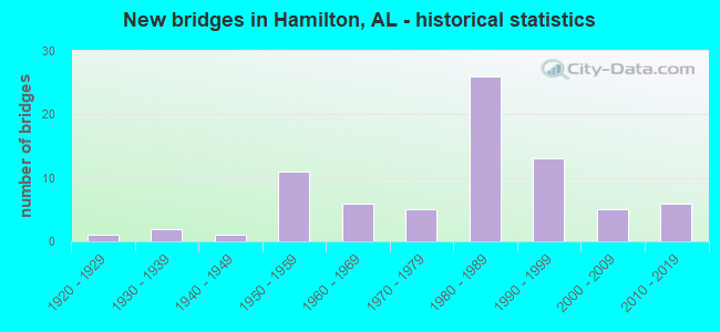
- New bridges - historical statistics
- 11920-1929
- 21930-1939
- 11940-1949
- 111950-1959
- 61960-1969
- 51970-1979
- 261980-1989
- 131990-1999
- 52000-2009
- 62010-2019

- Reconstructed bridges - Historical Statistics
- 31940-1949
- 01950-1959
- 01960-1969
- 11970-1979
- 11980-1989
- 01990-1999
- 02000-2009
- 12010-2019


- Bridge Condition - Deck
- 3.4%Excellent
- 13.8%Very good
- 48.3%Good
- 27.6%Satisfactory
- 6.9%Fair

- Bridge Condition - Superstructure
- 3.4%Excellent
- 17.2%Very good
- 62.1%Good
- 6.9%Satisfactory
- 10.3%Fair

- Bridge Condition - Substructure
- 3.4%Excellent
- 24.1%Very good
- 55.2%Good
- 17.2%Satisfactory

- Bridge Condition - Channel
- 18.0%Very good
- 20.0%Good
- 46.0%Satisfactory
- 16.0%Fair

- Bridge Condition - Culverts
- 3.1%Very good
- 18.8%Good
- 62.5%Satisfactory
- 15.6%Fair
Find on map >> Show street view
Structure Number: 15528, Location: 3.6 MI W JCT AL-253 (Lat: 34.117028, Lng: -87.860778), Route carried "on" structure: US 278, Year Built: 1992, Status: Open, Structure Length: 0.76m (2.49ft), Average Daily Traffic: 2,000 (year 2020), Truck Traffic: 14%, Average Future Daily Traffic: 2,500 (year 2040), Design Load: HS 20, Features Intersected: Creek, Facility Carried by Structure: AL-74
Minimum Vertical Clearance: 30+ m (98+ ft), Kilometerpoint: 19.908, Lanes on structure: 2, Base Highway Network: Yes, Owner: State Highway Agency, Approaching Roadway Width: 12.2m (40.0ft), Material/Design: Concrete, Design/Construction: Culvert, Number Of Spans In Main Unit: 3, Length of Maximum Span: 2.4m (7.9ft)
Condition: Channel: Satisfactory, Culverts: Satisfactory, Operating Rating: 88.9 metric tons, Method Used To Determine Operating Rating: Load Factor (LF), Inventory Rating: 88.9 metric tons, Method Used To Determine Inventory Rating: Load Factor (LF), Structural Evaluation: Equal to present minimum criteria, Waterway Adequacy: Better than present minimum criteria, Approach Roadway Alignment: Equal to present desirable criteria, Length Of Structure Improvement: 1.41m (4.63ft), Designated Inspection Frequency: Every 24 months, Inspection Date: January 2022, Bridge Improvement Cost: $1,431,000, Roadway Improvement Cost: $143,000, Total Project Cost: $1,574,000 ( Estimate for 2022)
Find on map >> Show street view
Structure Number: 15717, Location: 2.6 MI E US-43 (Lat: 34.049508, Lng: -87.933750), Route carried "on" structure: County highway 4, Year Built: 1992, Status: Open, Structure Length: 9.14m (29.99ft), Average Daily Traffic: 121 (year 2020), Truck Traffic: 8%, Average Future Daily Traffic: 300 (year 2040), Design Load: HS 20, Features Intersected: I-22, Facility Carried by Structure: CR-2
Minimum Vertical Clearance: 30+ m (98+ ft), Kilometerpoint: 19.389, Lanes on structure: 2, Lanes under structure: 4, Owner: State Highway Agency, Approaching Roadway Width: 6.0m (19.7ft), Material/Design: Prestressed concrete, Design/Construction: Stringer/Multi-beam, Number Of Spans In Main Unit: 4, Length of Maximum Span: 27.4m (89.9ft), Curb-To-Curb Width: 8.5m (27.9ft), Out-to-Out Width: 9.4m (30.8ft)
Condition: Deck: Good, Superstructure: Good, Substructure: Good, Operating Rating: 64.6 metric tons, Method Used To Determine Operating Rating: Load Factor (LF), Inventory Rating: 46.4 metric tons, Method Used To Determine Inventory Rating: Load Factor (LF), Structural Evaluation: Better than present minimum criteria, Deck Geometry: Equal to present minimum criteria, Underclear: Superior to present desirable criteria, Approach Roadway Alignment: Equal to present desirable criteria, Length Of Structure Improvement: 10.11m (33.17ft), Designated Inspection Frequency: Every 24 months, Inspection Date: July 2020, Bridge Improvement Cost: $2,079,000, Roadway Improvement Cost: $208,000, Total Project Cost: $2,287,000 ( Estimate for 2022), Deck Structure Type: Concrete Cast-file-Place
Find on map >> Show street view
Structure Number: 16044, Location: JCT US 43 * AL-4 (Lat: 34.072064, Lng: -87.975950), Route carried "on" structure: Interstate 22, Year Built: 1992, Status: Open, Structure Length: 7.35m (24.11ft), Average Daily Traffic: 4,920 (year 2020), Truck Traffic: 38%, Average Future Daily Traffic: 6,666 (year 2040), Design Load: HS 20, Features Intersected: US-43
Minimum Vertical Clearance: 30+ m (98+ ft), Kilometerpoint: 27.196, Lanes on structure: 2, Lanes under structure: 3, Base Highway Network: Yes, Owner: State Highway Agency, Approaching Roadway Width: 10.7m (35.1ft), Skew: 13 degrees, Material/Design: Steel, Design/Construction: Stringer/Multi-beam, Number Of Spans In Main Unit: 1, Number Of Approach Spans: 2, Length of Maximum Span: 36.6m (120.1ft), Curb-To-Curb Width: 12.2m (40.0ft), Out-to-Out Width: 13.0m (42.7ft)
Condition: Deck: Good, Superstructure: Good, Substructure: Good, Operating Rating: 66.8 metric tons, Method Used To Determine Operating Rating: Load Factor (LF), Inventory Rating: 37.8 metric tons, Method Used To Determine Inventory Rating: Load Factor (LF), Structural Evaluation: Better than present minimum criteria, Deck Geometry: Better than present minimum criteria, Underclear: Equal to present minimum criteria, Approach Roadway Alignment: Equal to present desirable criteria, Length Of Structure Improvement: 8.37m (27.46ft), Designated Inspection Frequency: Every 24 months, Inspection Date: June 2020, Bridge Improvement Cost: $2,412,000, Roadway Improvement Cost: $241,000, Total Project Cost: $2,653,000 ( Estimate for 2022), Deck Structure Type: Concrete Cast-file-Place
Find on map >> Show street view
Structure Number: 16045, Location: JCT US 43 AL-4 (Lat: 34.071806, Lng: -87.975894), Route carried "on" structure: Interstate 22, Year Built: 1992, Status: Open, Structure Length: 7.35m (24.11ft), Average Daily Traffic: 4,920 (year 2020), Truck Traffic: 38%, Average Future Daily Traffic: 6,666 (year 2040), Design Load: HS 20, Features Intersected: US-43
Minimum Vertical Clearance: 30+ m (98+ ft), Kilometerpoint: 27.196, Lanes on structure: 2, Lanes under structure: 3, Base Highway Network: Yes, Owner: State Highway Agency, Approaching Roadway Width: 10.7m (35.1ft), Skew: 13 degrees, Material/Design: Steel, Design/Construction: Stringer/Multi-beam, Number Of Spans In Main Unit: 1, Number Of Approach Spans: 2, Length of Maximum Span: 36.6m (120.1ft), Curb-To-Curb Width: 12.2m (40.0ft), Out-to-Out Width: 13.0m (42.7ft)
Condition: Deck: Good, Superstructure: Very good, Substructure: Very good, Operating Rating: 66.8 metric tons, Method Used To Determine Operating Rating: Load Factor (LF), Inventory Rating: 37.8 metric tons, Method Used To Determine Inventory Rating: Load Factor (LF), Structural Evaluation: Equal to present desirable criteria, Deck Geometry: Better than present minimum criteria, Underclear: Superior to present desirable criteria, Approach Roadway Alignment: Equal to present desirable criteria, Length Of Structure Improvement: 8.37m (27.46ft), Designated Inspection Frequency: Every 24 months, Inspection Date: June 2020, Bridge Improvement Cost: $2,412,000, Roadway Improvement Cost: $241,000, Total Project Cost: $2,653,000 ( Estimate for 2022), Deck Structure Type: Concrete Cast-file-Place
Find on map >> Show street view
Structure Number: 16059, Location: 0.9 MI E OF US-43 (Lat: 34.067972, Lng: -87.961222), Route carried "on" structure: Interstate 22, Year Built: 1992, Status: Open, Structure Length: 0.98m (3.22ft), Average Daily Traffic: 10,120 (year 2013), Truck Traffic: 34%, Average Future Daily Traffic: 13,711 (year 2038), Design Load: HS 20, Features Intersected: Dougan Creek
Minimum Vertical Clearance: 30+ m (98+ ft), Kilometerpoint: 28.645, Lanes on structure: 4, Base Highway Network: Yes, Owner: State Highway Agency, Approaching Roadway Width: 24.0m (78.7ft), Skew: 21 degrees, Material/Design: Concrete, Design/Construction: Culvert, Number Of Spans In Main Unit: 2, Length of Maximum Span: 4.3m (14.1ft)
Condition: Channel: Good, Culverts: Good, Operating Rating: 88.9 metric tons, Method Used To Determine Operating Rating: Load Factor (LF), Inventory Rating: 88.9 metric tons, Method Used To Determine Inventory Rating: Load Factor (LF), Structural Evaluation: Better than present minimum criteria, Waterway Adequacy: Equal to present desirable criteria, Approach Roadway Alignment: Equal to present desirable criteria, Length Of Structure Improvement: 1.65m (5.41ft), Designated Inspection Frequency: Every 24 months, Inspection Date: May 2020, Bridge Improvement Cost: $3,075,000, Roadway Improvement Cost: $308,000, Total Project Cost: $3,383,000 ( Estimate for 2022)
Find on map >> Show street view
Structure Number: 16314, Location: 1.6 KM E OF CO RD 11 (Lat: 34.167042, Lng: -88.090261), Route carried "on" structure: County highway 94, Year Built: 1994, Status: Open, Structure Length: 4.15m (13.62ft), Average Daily Traffic: 390 (year 2001), Truck Traffic: 20%, Average Future Daily Traffic: 982 (year 2036), Design Load: HS 20, Features Intersected: BOARDTREE CREEK
Minimum Vertical Clearance: 30+ m (98+ ft), Kilometerpoint: 0.161, Lanes on structure: 2, Owner: County Highway Agency, Approaching Roadway Width: 9.1m (29.9ft), Material/Design: Concrete, Design/Construction: Channel Beam, Number Of Spans In Main Unit: 4, Length of Maximum Span: 10.4m (34.1ft), Curb-To-Curb Width: 8.5m (27.9ft), Out-to-Out Width: 9.3m (30.5ft)
Condition: Deck: Satisfactory, Superstructure: Good, Substructure: Satisfactory, Channel: Good, Operating Rating: 67.6 metric tons, Method Used To Determine Operating Rating: Load Factor (LF), Inventory Rating: 40.6 metric tons, Method Used To Determine Inventory Rating: Load Factor (LF), Structural Evaluation: Equal to present minimum criteria, Deck Geometry: Equal to present minimum criteria, Waterway Adequacy: Equal to present minimum criteria, Approach Roadway Alignment: Equal to present desirable criteria, Length Of Structure Improvement: 5.12m (16.80ft), Designated Inspection Frequency: Every 24 months, Inspection Date: April 2020, Bridge Improvement Cost: $1,053,000, Roadway Improvement Cost: $105,000, Total Project Cost: $1,158,000 ( Estimate for 2022), Deck Structure Type: Concrete Precast Panels
Find on map >> Show street view
Structure Number: 16315, Location: 1.3 KM E OF CO RD 11 (Lat: 34.166700, Lng: -88.093550), Route carried "on" structure: County highway 94, Year Built: 1994, Status: Open, Structure Length: 3.11m (10.20ft), Average Daily Traffic: 390 (year 2001), Truck Traffic: 10%, Average Future Daily Traffic: 982 (year 2036), Design Load: HS 20, Features Intersected: BOARDTREE CREEK
Minimum Vertical Clearance: 30+ m (98+ ft), Kilometerpoint: 0.161, Lanes on structure: 2, Owner: County Highway Agency, Approaching Roadway Width: 9.1m (29.9ft), Material/Design: Concrete, Design/Construction: Channel Beam, Number Of Spans In Main Unit: 3, Length of Maximum Span: 10.4m (34.1ft), Curb-To-Curb Width: 8.5m (27.9ft), Out-to-Out Width: 9.3m (30.5ft)
Condition: Deck: Satisfactory, Superstructure: Satisfactory, Substructure: Satisfactory, Channel: Satisfactory, Operating Rating: 74.1 metric tons, Method Used To Determine Operating Rating: Load Factor (LF), Inventory Rating: 44.5 metric tons, Method Used To Determine Inventory Rating: Load Factor (LF), Structural Evaluation: Equal to present minimum criteria, Deck Geometry: Equal to present minimum criteria, Waterway Adequacy: Equal to present minimum criteria, Approach Roadway Alignment: Equal to present minimum criteria, Length Of Structure Improvement: 3.96m (12.99ft), Designated Inspection Frequency: Every 24 months, Inspection Date: April 2020, Bridge Improvement Cost: $815,000, Roadway Improvement Cost: $82,000, Total Project Cost: $897,000 ( Estimate for 2022), Deck Structure Type: Concrete Precast Panels
Find on map >> Show street view
Structure Number: 18094, Location: 0.3 MI. East AL-17 (Lat: 34.141306, Lng: -87.983194), Route carried "on" structure: US 278, Year Built: 2008, Status: Open, Structure Length: 4.57m (14.99ft), Average Daily Traffic: 5,055 (year 2020), Truck Traffic: 10%, Average Future Daily Traffic: 6,000 (year 2040), Design Load: HS 20, Features Intersected: Ragsdale Creek, Facility Carried by Structure: AL-74
Minimum Vertical Clearance: 30+ m (98+ ft), Kilometerpoint: 8.095, Lanes on structure: 5, Base Highway Network: Yes, Owner: State Highway Agency, Approaching Roadway Width: 21.8m (71.5ft), Material/Design: Prestressed concrete, Design/Construction: Stringer/Multi-beam, Number Of Spans In Main Unit: 3, Length of Maximum Span: 18.3m (60.0ft), Curb or Sidewalk Widths: Left: 0.0m, Right: 1.8m (5.9ft), Curb-To-Curb Width: 23.3m (76.4ft), Out-to-Out Width: 25.9m (85.0ft)
Condition: Deck: Very good, Superstructure: Good, Substructure: Good, Channel: Very good, Operating Rating: 67.0 metric tons, Method Used To Determine Operating Rating: Load Factor (LF), Inventory Rating: 38.9 metric tons, Method Used To Determine Inventory Rating: Load Factor (LF), Structural Evaluation: Better than present minimum criteria, Deck Geometry: Better than present minimum criteria, Waterway Adequacy: Superior to present desirable criteria, Approach Roadway Alignment: Superior to present desirable criteria, Length Of Structure Improvement: 5.57m (18.27ft), Designated Inspection Frequency: Every 24 months, Inspection Date: January 2022, Bridge Improvement Cost: $3,207,000, Roadway Improvement Cost: $321,000, Total Project Cost: $3,528,000 ( Estimate for 2022), Deck Structure Type: Concrete Cast-file-Place
Find on map >> Show street view
Structure Number: 18587, Location: 1.1 MI E JCT US-43 (Lat: 34.143333, Lng: -87.970167), Route carried "on" structure: US 278, Year Built: 2015, Status: Open, Structure Length: 11.13m (36.52ft), Average Daily Traffic: 4,000 (year 2020), Truck Traffic: 9%, Average Future Daily Traffic: 5,000 (year 2041), Design Load: HS 20, Features Intersected: Buttahatchee River, Facility Carried by Structure: AL-74
Minimum Vertical Clearance: 30+ m (98+ ft), Kilometerpoint: 9.366, Lanes on structure: 5, Owner: State Highway Agency, Approaching Roadway Width: 24.7m (81.0ft), Material/Design: Prestressed concrete, Design/Construction: Stringer/Multi-beam, Number Of Spans In Main Unit: 3, Length of Maximum Span: 41.1m (134.8ft), Curb-To-Curb Width: 24.7m (81.0ft), Out-to-Out Width: 25.7m (84.3ft)
Condition: Deck: Very good, Superstructure: Very good, Substructure: Very good, Channel: Very good, Operating Rating: 88.9 metric tons, Method Used To Determine Operating Rating: Load Factor (LF), Inventory Rating: 50.1 metric tons, Method Used To Determine Inventory Rating: Load Factor (LF), Structural Evaluation: Equal to present desirable criteria, Deck Geometry: Superior to present desirable criteria, Waterway Adequacy: Superior to present desirable criteria, Approach Roadway Alignment: Equal to present desirable criteria, Length Of Structure Improvement: 12.01m (39.40ft), Designated Inspection Frequency: Every 24 months, Inspection Date: January 2022, Bridge Improvement Cost: $6,917,000, Roadway Improvement Cost: $692,000, Total Project Cost: $7,609,000 ( Estimate for 2020), Deck Structure Type: Concrete Cast-file-Place
Find on map >> Show street view
Structure Number: 18663, Location: 0.2 MI W JCT US 43 (Lat: 34.116942, Lng: -87.998694), Route carried "on" structure: City street , Year Built: 2000, Status: Open, Structure Length: 1.07m (3.51ft), Average Daily Traffic: 280 (year 2016), Truck Traffic: 5%, Average Future Daily Traffic: 350 (year 2036), Design Load: HS 20, Features Intersected: KEY BRANCH, Facility Carried by Structure: 10 TH AVE S
Minimum Vertical Clearance: 30+ m (98+ ft), Kilometerpoint: 0.000, Lanes on structure: 2, Owner: City or Municipal Highway Agency, Approaching Roadway Width: 8.5m (27.9ft), Skew: 3 degrees, Material/Design: Concrete, Design/Construction: Culvert, Number Of Spans In Main Unit: 4, Length of Maximum Span: 2.4m (7.9ft), Curb-To-Curb Width: 10.8m (35.4ft), Out-to-Out Width: 11.3m (37.1ft)
Condition: Channel: Fair, Culverts: Fair, Operating Rating: 83.9 metric tons, Method Used To Determine Operating Rating: Load Factor (LF), Inventory Rating: 50.3 metric tons, Method Used To Determine Inventory Rating: Load Factor (LF), Structural Evaluation: Somewhat better than minimum adequacy, Deck Geometry: Better than present minimum criteria, Waterway Adequacy: Better than present minimum criteria, Approach Roadway Alignment: Equal to present desirable criteria, Length Of Structure Improvement: 1.74m (5.71ft), Designated Inspection Frequency: Every 24 months, Inspection Date: January 2022, Bridge Improvement Cost: $371,000, Roadway Improvement Cost: $37,000, Total Project Cost: $408,000 ( Estimate for 2022), Deck Structure Type: Concrete Cast-file-Place, Wearing Surface/Protective System: Wearing Surface: Bituminous
Find on map >> Show street view
Structure Number: 18664, Location: 0.3 MI W OF JCT US 43 (Lat: 34.110275, Lng: -88.005683), Route carried "on" structure: City street , Year Built: 1999, Status: Open, Structure Length: 0.75m (2.46ft), Average Daily Traffic: 300 (year 2016), Truck Traffic: 5%, Average Future Daily Traffic: 350 (year 2036), Design Load: HS 20, Features Intersected: BRANCH, Facility Carried by Structure: STEELE ST
Minimum Vertical Clearance: 30+ m (98+ ft), Kilometerpoint: 0.000, Lanes on structure: 2, Owner: City or Municipal Highway Agency, Approaching Roadway Width: 5.2m (17.1ft), Skew: 4 degrees, Material/Design: Concrete, Design/Construction: Culvert, Number Of Spans In Main Unit: 2, Length of Maximum Span: 3.0m (9.8ft), Curb-To-Curb Width: 8.7m (28.5ft), Out-to-Out Width: 9.2m (30.2ft)
Condition: Channel: Fair, Culverts: Satisfactory, Operating Rating: 40.6 metric tons, Method Used To Determine Operating Rating: Load Factor (LF), Inventory Rating: 24.3 metric tons, Method Used To Determine Inventory Rating: Load Factor (LF), Structural Evaluation: Equal to present minimum criteria, Deck Geometry: Equal to present minimum criteria, Waterway Adequacy: Better than present minimum criteria, Approach Roadway Alignment: Equal to present desirable criteria, Length Of Structure Improvement: 1.39m (4.56ft), Designated Inspection Frequency: Every 24 months, Inspection Date: January 2022, Bridge Improvement Cost: $241,000, Roadway Improvement Cost: $24,000, Total Project Cost: $265,000 ( Estimate for 2022), Deck Structure Type: Concrete Cast-file-Place, Wearing Surface/Protective System: Wearing Surface: Bituminous
Find on map >> Show street view
Structure Number: 1883, Location: 1.5 MILES EAST OF ST 171 (Lat: 34.131514, Lng: -87.981486), Route carried "on" structure: County highway 42, Year Built: 2004, Status: Open, Structure Length: 10.52m (34.51ft), Average Daily Traffic: 1,751 (year 2003), Truck Traffic: 14%, Average Future Daily Traffic: 2,989 (year 2035), Design Load: HS 20, Features Intersected: BUTTAHATCHEE RIVER
Minimum Vertical Clearance: 30+ m (98+ ft), Kilometerpoint: 0.010, Lanes on structure: 2, Owner: County Highway Agency, Approaching Roadway Width: 9.8m (32.2ft), Material/Design: Prestressed concrete, Design/Construction: Stringer/Multi-beam, Number Of Spans In Main Unit: 3, Length of Maximum Span: 41.1m (134.8ft), Curb-To-Curb Width: 9.8m (32.2ft), Out-to-Out Width: 10.6m (34.8ft)
Condition: Deck: Good, Superstructure: Good, Substructure: Very good, Channel: Good, Operating Rating: 73.9 metric tons, Method Used To Determine Operating Rating: Load Factor (LF), Inventory Rating: 43.4 metric tons, Method Used To Determine Inventory Rating: Load Factor (LF), Structural Evaluation: Better than present minimum criteria, Deck Geometry: Somewhat better than minimum adequacy, Waterway Adequacy: Superior to present desirable criteria, Approach Roadway Alignment: Better than present minimum criteria, Length Of Structure Improvement: 11.42m (37.47ft), Designated Inspection Frequency: Every 24 months, Inspection Date: November 2020, Bridge Improvement Cost: $2,663,000, Roadway Improvement Cost: $266,000, Total Project Cost: $2,929,000 ( Estimate for 2022), Deck Structure Type: Concrete Cast-file-Place
Find on map >> Show street view
Structure Number: 1901, Location: 2.5 MI. NE. HENSON SPRING (Lat: 34.032389, Lng: -88.026722), Route carried "on" structure: County highway , Year Built: 2003, Status: Open, Structure Length: 1.58m (5.18ft), Average Daily Traffic: 50 (year 2003), Average Future Daily Traffic: 75 (year 2032), Design Load: HS 20, Features Intersected: CANTRELL MILL CREEK, Facility Carried by Structure: FOUR OAKS ROAD
Minimum Vertical Clearance: 30+ m (98+ ft), Kilometerpoint: 0.010, Lanes on structure: 2, Owner: County Highway Agency, Approaching Roadway Width: 10.7m (35.1ft), Skew: 3 degrees, Material/Design: Concrete, Design/Construction: Culvert, Number Of Spans In Main Unit: 3, Length of Maximum Span: 4.3m (14.1ft)
Condition: Channel: Very good, Culverts: Satisfactory, Operating Rating: 88.4 metric tons, Method Used To Determine Operating Rating: Load Factor (LF), Inventory Rating: 53.0 metric tons, Method Used To Determine Inventory Rating: Load Factor (LF), Structural Evaluation: Equal to present minimum criteria, Waterway Adequacy: Superior to present desirable criteria, Approach Roadway Alignment: Better than present minimum criteria, Length Of Structure Improvement: 2.27m (7.45ft), Designated Inspection Frequency: Every 24 months, Inspection Date: December 2020, Bridge Improvement Cost: $852,000, Roadway Improvement Cost: $85,000, Total Project Cost: $937,000 ( Estimate for 2022)
Find on map >> Show street view
Structure Number: 20123, Location: 2 MI S JCT AL-17 (Lat: 34.105944, Lng: -87.989089), Route carried "on" structure: US 43, Year Built: 2017, Status: Open, Structure Length: 12.80m (41.99ft), Average Daily Traffic: 3,891 (year 2020), Truck Traffic: 6%, Average Future Daily Traffic: 5,000 (year 2041), Design Load: HL 93, Features Intersected: Buttahatchee River, Facility Carried by Structure: AL-171
Minimum Vertical Clearance: 30+ m (98+ ft), Kilometerpoint: 114.432, Lanes on structure: 4, Base Highway Network: Yes, Owner: State Highway Agency, Approaching Roadway Width: 25.0m (82.0ft), Skew: 13 degrees, Material/Design: Prestressed concrete, Design/Construction: Stringer/Multi-beam, Number Of Spans In Main Unit: 1, Number Of Approach Spans: 2, Length of Maximum Span: 0.0m, Curb-To-Curb Width: 25.0m (82.0ft), Out-to-Out Width: 25.7m (84.3ft)
Condition: Deck: Very good, Superstructure: Very good, Substructure: Very good, Channel: Very good, Operating Rating: 88.9 metric tons, Method Used To Determine Operating Rating: Load Factor (LF), Inventory Rating: 60.3 metric tons, Method Used To Determine Inventory Rating: Load Factor (LF), Structural Evaluation: Equal to present desirable criteria, Deck Geometry: Superior to present desirable criteria, Waterway Adequacy: Equal to present desirable criteria, Approach Roadway Alignment: Superior to present desirable criteria, Length Of Structure Improvement: 13.63m (44.72ft), Designated Inspection Frequency: Every 24 months, Inspection Date: September 2021, Bridge Improvement Cost: $7,851,000, Roadway Improvement Cost: $785,000, Total Project Cost: $8,636,000 ( Estimate for 2022), Deck Structure Type: Concrete Cast-file-Place, Wearing Surface/Protective System: Wearing Surface: Integral Concrete
Find on map >> Show street view
Structure Number: 209, Location: 1/2 mile east of us 43 (Lat: 34.149908, Lng: -87.977139), Route carried "on" structure: City street , Year Built: 2018, Status: Open, Structure Length: 7.01m (23.00ft), Average Daily Traffic: 509 (year 2018), Truck Traffic: 4%, Average Future Daily Traffic: 758 (year 2038), Design Load: HS 20, Features Intersected: Williams Creek, Facility Carried by Structure: Grandview Drive
Minimum Vertical Clearance: 0.00m, Kilometerpoint: 0.000, Lanes on structure: 2, Owner: City or Municipal Highway Agency, Approaching Roadway Width: 9.1m (29.9ft), Material/Design: Prestressed concrete, Design/Construction: Stringer/Multi-beam, Number Of Spans In Main Unit: 2, Length of Maximum Span: 35.1m (115.2ft), Curb-To-Curb Width: 7.3m (24.0ft), Out-to-Out Width: 8.5m (27.9ft)
Condition: Deck: Good, Superstructure: Very good, Substructure: Very good, Channel: Very good, Operating Rating: 88.9 metric tons, Method Used To Determine Operating Rating: Load Factor (LF), Inventory Rating: 51.7 metric tons, Method Used To Determine Inventory Rating: Load Factor (LF), Structural Evaluation: Equal to present desirable criteria, Deck Geometry: High priority of corrective action, Waterway Adequacy: Better than present minimum criteria, Approach Roadway Alignment: Better than present minimum criteria, Length Of Structure Improvement: 8.04m (26.38ft), Designated Inspection Frequency: Every 24 months, Inspection Date: January 2022, Bridge Improvement Cost: $1,544,000, Roadway Improvement Cost: $154,000, Total Project Cost: $1,698,000 ( Estimate for 2022), Deck Structure Type: Concrete Cast-file-Place
Find on map >> Show street view
Structure Number: 20947, Location: 6 miles east of Miss line (Lat: 34.158031, Lng: -88.100756), Route carried "on" structure: County highway 11, Year Built: 2018, Status: Open, Structure Length: 6.10m (20.01ft), Average Daily Traffic: 100 (year 2001), Average Future Daily Traffic: 159 (year 2035), Design Load: HS 20, Features Intersected: Boardtree Creek
Minimum Vertical Clearance: 0.00m, Kilometerpoint: 0.010, Lanes on structure: 2, Owner: County Highway Agency, Approaching Roadway Width: 7.3m (24.0ft), Material/Design: Concrete, Design/Construction: Channel Beam, Number Of Spans In Main Unit: 5, Length of Maximum Span: 12.2m (40.0ft), Curb-To-Curb Width: 8.5m (27.9ft), Out-to-Out Width: 9.4m (30.8ft)
Condition: Deck: Very good, Superstructure: Very good, Substructure: Very good, Channel: Very good, Operating Rating: 88.9 metric tons, Method Used To Determine Operating Rating: Load Factor (LF), Inventory Rating: 56.0 metric tons, Method Used To Determine Inventory Rating: Load Factor (LF), Structural Evaluation: Equal to present desirable criteria, Deck Geometry: Better than present minimum criteria, Waterway Adequacy: Better than present minimum criteria, Approach Roadway Alignment: Equal to present desirable criteria, Length Of Structure Improvement: 7.14m (23.43ft), Designated Inspection Frequency: Every 24 months, Inspection Date: November 2020, Bridge Improvement Cost: $1,468,000, Roadway Improvement Cost: $147,000, Total Project Cost: $1,615,000 ( Estimate for 2022), Deck Structure Type: Concrete Precast Panels
Find on map >> Show street view
Structure Number: 20948, Location: 6 miles east of Miss Line (Lat: 34.145150, Lng: -88.094836), Route carried "on" structure: County highway 9, Year Built: 2019, Status: Open, Structure Length: 3.66m (12.01ft), Average Daily Traffic: 44 (year 2019), Truck Traffic: 12%, Average Future Daily Traffic: 65 (year 2039), Design Load: HS 20, Features Intersected: BARNESVILLE CREEK
Minimum Vertical Clearance: 0.00m, Kilometerpoint: 0.010, Lanes on structure: 2, Owner: County Highway Agency, Approaching Roadway Width: 7.3m (24.0ft), Material/Design: Concrete, Design/Construction: Channel Beam, Number Of Spans In Main Unit: 3, Length of Maximum Span: 12.2m (40.0ft), Curb-To-Curb Width: 7.5m (24.6ft), Out-to-Out Width: 8.2m (26.9ft)
Condition: Deck: Excellent, Superstructure: Excellent, Substructure: Excellent, Channel: Very good, Operating Rating: 88.9 metric tons, Method Used To Determine Operating Rating: Load Factor (LF), Inventory Rating: 54.4 metric tons, Method Used To Determine Inventory Rating: Load Factor (LF), Structural Evaluation: Superior to present desirable criteria, Deck Geometry: Equal to present minimum criteria, Waterway Adequacy: Better than present minimum criteria, Approach Roadway Alignment: Equal to present desirable criteria, Length Of Structure Improvement: 4.58m (15.03ft), Designated Inspection Frequency: Every 24 months, Inspection Date: September 2021, Bridge Improvement Cost: $847,000, Roadway Improvement Cost: $85,000, Total Project Cost: $932,000 ( Estimate for 2022), Deck Structure Type: Concrete Precast Panels
Find on map >> Show street view
Structure Number: 21359, Location: 1700' off St Hwy 253 (Lat: 34.169400, Lng: -87.836625), Route carried "on" structure: County highway , Year Built: 2016, Status: Open, Structure Length: 0.94m (3.08ft), Average Daily Traffic: 11 (year 2018), Truck Traffic: 1%, Average Future Daily Traffic: 16 (year 2038), Design Load: HS 20, Features Intersected: Little Camp Creek, Facility Carried by Structure: Camp Creek Rd
Minimum Vertical Clearance: 30+ m (98+ ft), Kilometerpoint: 0.010, Lanes on structure: 2, Owner: County Highway Agency, Approaching Roadway Width: 4.9m (16.1ft), Material/Design: Steel, Design/Construction: Culvert, Number Of Spans In Main Unit: 4, Length of Maximum Span: 1.8m (5.9ft)
Condition: Channel: Satisfactory, Culverts: Very good, Operating Rating: 35.5 metric tons, Method Used To Determine Operating Rating: Load Factor (LF), Inventory Rating: 32.7 metric tons, Method Used To Determine Inventory Rating: Load Factor (LF), Structural Evaluation: Equal to present desirable criteria, Waterway Adequacy: Equal to present minimum criteria, Approach Roadway Alignment: Better than present minimum criteria, Length Of Structure Improvement: 1.62m (5.31ft), Designated Inspection Frequency: Every 24 months, Inspection Date: January 2022, Bridge Improvement Cost: $374,000, Roadway Improvement Cost: $37,000, Total Project Cost: $411,000 ( Estimate for 2022)
Find on map >> Show street view
Structure Number: 2136, Location: _300' East of St Hwy 19 (Lat: 34.197792, Lng: -88.069167), Route carried "on" structure: County highway 122, Year Built: 2000, Status: Open, Structure Length: 0.79m (2.59ft), Average Daily Traffic: 96 (year 2018), Truck Traffic: 4%, Average Future Daily Traffic: 143 (year 2038), Design Load: HS 20, Features Intersected: _Rason Branch
Minimum Vertical Clearance: 30+ m (98+ ft), Kilometerpoint: 0.010, Lanes on structure: 2, Owner: County Highway Agency, Approaching Roadway Width: 4.9m (16.1ft), Material/Design: Steel, Design/Construction: Culvert, Number Of Spans In Main Unit: 3, Length of Maximum Span: 2.1m (6.9ft), Curb-To-Curb Width: 4.9m (16.1ft), Out-to-Out Width: 4.9m (16.1ft)
Condition: Channel: Fair, Culverts: Fair, Operating Rating: 48.5 metric tons, Method Used To Determine Operating Rating: Load Factor (LF), Inventory Rating: 47.0 metric tons, Method Used To Determine Inventory Rating: Load Factor (LF), Structural Evaluation: Somewhat better than minimum adequacy, Deck Geometry: High priority of corrective action, Waterway Adequacy: Better than present minimum criteria, Approach Roadway Alignment: Equal to present minimum criteria, Length Of Structure Improvement: 1.45m (4.76ft), Designated Inspection Frequency: Every 24 months, Inspection Date: January 2022, Bridge Improvement Cost: $335,000, Roadway Improvement Cost: $34,000, Total Project Cost: $369,000 ( Estimate for 2022)
Find on map >> Show street view
Structure Number: 13683, Location: 3.01 MI W AL-74 (Lat: 34.189889, Lng: -88.108556), Route carried "under" structure: Interstate 22, Year Built: 1986, Structure Length: 0. m, Average Daily Traffic: 11,620 (year 2018), Truck Traffic: 33%, Features Intersected: I-22, Facility Carried by Structure: CR-11
Minimum Vertical Clearance: 5.15m (16.90ft), Kilometerpoint: 7.643, Lanes on structure: 2, Lanes under structure: 4, Material/Design: Steel, Design/Construction: Stringer/Multi-beam, Length of Maximum Span: 30.2m (99.1ft)
Find on map >> Show street view
Structure Number: 13684, Location: 1.45 MI W AL-74 (Lat: 34.181861, Lng: -88.086722), Route carried "under" structure: Interstate 22, Year Built: 1986, Structure Length: 0. m, Average Daily Traffic: 11,620 (year 2018), Truck Traffic: 33%, Features Intersected: I-22, Facility Carried by Structure: CR-9
Minimum Vertical Clearance: 5.70m (18.70ft), Kilometerpoint: 9.986, Lanes on structure: 2, Lanes under structure: 4, Material/Design: Steel, Design/Construction: Stringer/Multi-beam, Length of Maximum Span: 29.0m (95.1ft)
Find on map >> Show street view
Structure Number: 14503, Location: JCT AL-74 AND AL-4 (Lat: 34.167222, Lng: -88.065167), Route carried "under" structure: Interstate 22, Year Built: 1988, Structure Length: 0. m, Average Daily Traffic: 11,490 (year 2018), Truck Traffic: 38%, Features Intersected: I-22, Facility Carried by Structure: AL-74
Minimum Vertical Clearance: 5.20m (17.06ft), Kilometerpoint: 12.575, Lanes on structure: 3, Lanes under structure: 4, Material/Design: Prestressed concrete, Design/Construction: Stringer/Multi-beam, Length of Maximum Span: 28.0m (91.9ft)
Find on map >> Show street view
Structure Number: 14541, Location: JCT AL-17 AND AL-4 (Lat: 34.120014, Lng: -88.045828), Route carried "under" structure: Interstate 22, Year Built: 1988, Structure Length: 0. m, Average Daily Traffic: 11,620 (year 2019), Truck Traffic: 33%, Features Intersected: I-22, Facility Carried by Structure: AL-17
Minimum Vertical Clearance: 5.30m (17.39ft), Kilometerpoint: 11.399, Lanes on structure: 2, Lanes under structure: 4, Material/Design: Steel continuous, Design/Construction: Stringer/Multi-beam, Length of Maximum Span: 48.8m (160.1ft)
Find on map >> Show street view
Structure Number: 14544, Location: JCT AL-19 AND AL-4 (Lat: 34.147333, Lng: -88.059583), Route carried "under" structure: Interstate 22, Year Built: 1988, Structure Length: 0. m, Average Daily Traffic: 11,620 (year 2019), Truck Traffic: 33%, Features Intersected: I-22, Facility Carried by Structure: AL-19
Minimum Vertical Clearance: 6.20m (20.34ft), Kilometerpoint: 9.189, Lanes on structure: 2, Lanes under structure: 4, Material/Design: Prestressed concrete, Design/Construction: Stringer/Multi-beam, Length of Maximum Span: 27.1m (88.9ft)
Find on map >> Show street view
Structure Number: 14642, Location: 1.2 MI S AL-19 (Lat: 34.130833, Lng: -88.058278), Route carried "under" structure: Interstate 22, Year Built: 1988, Structure Length: 0. m, Average Daily Traffic: 11,490 (year 2018), Truck Traffic: 38%, Features Intersected: I-22, Facility Carried by Structure: CR-11
Minimum Vertical Clearance: 6.00m (19.69ft), Kilometerpoint: 16.758, Lanes on structure: 2, Lanes under structure: 4, Material/Design: Steel continuous, Design/Construction: Stringer/Multi-beam, Length of Maximum Span: 30.2m (99.1ft)
Find on map >> Show street view
Structure Number: 14643, Location: 0.9 MI S AL-17 (Lat: 34.113778, Lng: -88.030972), Route carried "under" structure: Interstate 22, Year Built: 1988, Structure Length: 0. m, Average Daily Traffic: 11,330 (year 2018), Truck Traffic: 38%, Features Intersected: I-22, Facility Carried by Structure: CR-11
Minimum Vertical Clearance: 5.30m (17.39ft), Kilometerpoint: 20.020, Lanes on structure: 2, Lanes under structure: 4, Material/Design: Steel continuous, Design/Construction: Stringer/Multi-beam, Length of Maximum Span: 37.2m (122.0ft)
Find on map >> Show street view
Structure Number: 14644, Location: 2.8 MI W AL-171 (Lat: 34.095472, Lng: -88.013972), Route carried "under" structure: County highway , Year Built: 1988, Structure Length: 0. m, Average Daily Traffic: 50 (year 2018), Features Intersected: Buttahatchee River, Facility Carried by Structure: I-22
Minimum Vertical Clearance: 5.23m (17.16ft), Kilometerpoint: 14.019, Lanes on structure: 2, Lanes under structure: 2, Material/Design: Prestressed concrete, Design/Construction: Stringer/Multi-beam, Length of Maximum Span: 27.4m (89.9ft)
Find on map >> Show street view
Structure Number: 14645, Location: 2.8 MI W OF AL-171 (Lat: 34.095778, Lng: -88.013972), Route carried "under" structure: County highway , Year Built: 1988, Structure Length: 0. m, Average Daily Traffic: 50 (year 2018), Features Intersected: Buttahatchee River, Facility Carried by Structure: I-22
Minimum Vertical Clearance: 5.23m (17.16ft), Kilometerpoint: 23.461, Lanes on structure: 2, Lanes under structure: 2, Material/Design: Prestressed concrete, Design/Construction: Stringer/Multi-beam, Length of Maximum Span: 27.4m (89.9ft)
Find on map >> Show street view
Structure Number: 14646, Location: 2.4 MI W AL-171 (Lat: 34.090778, Lng: -88.008361), Route carried "under" structure: Interstate 22, Year Built: 1988, Structure Length: 0. m, Average Daily Traffic: 9,840 (year 2018), Truck Traffic: 38%, Features Intersected: I-22, Facility Carried by Structure: CR-35
Minimum Vertical Clearance: 5.30m (17.39ft), Kilometerpoint: 23.157, Lanes on structure: 2, Lanes under structure: 4, Material/Design: Steel continuous, Design/Construction: Stringer/Multi-beam, Length of Maximum Span: 30.5m (100.1ft)
Find on map >> Show street view
Structure Number: 14647, Location: 1.4 MI W AL-171 (Lat: 34.079250, Lng: -87.996639), Route carried "under" structure: Interstate 22, Year Built: 1988, Structure Length: 0. m, Average Daily Traffic: 9,840 (year 2018), Truck Traffic: 38%, Features Intersected: I-22, Facility Carried by Structure: CR-55
Minimum Vertical Clearance: 5.10m (16.73ft), Kilometerpoint: 25.132, Lanes on structure: 2, Lanes under structure: 4, Material/Design: Steel continuous, Design/Construction: Stringer/Multi-beam, Length of Maximum Span: 39.9m (130.9ft)
Find on map >> Show street view
Structure Number: 14648, Location: 0.3 MI N AL-171 (Lat: 34.072250, Lng: -87.981389), Route carried "under" structure: Interstate 22, Year Built: 1988, Structure Length: 0. m, Average Daily Traffic: 9,840 (year 2018), Truck Traffic: 38%, Features Intersected: I-22, Facility Carried by Structure: Berryhill Road
Minimum Vertical Clearance: 5.20m (17.06ft), Kilometerpoint: 26.889, Lanes on structure: 2, Lanes under structure: 4, Material/Design: Prestressed concrete, Design/Construction: Stringer/Multi-beam, Length of Maximum Span: 29.9m (98.1ft)
Find on map >> Show street view
Structure Number: 15717, Location: 2.6 MI E US-43 (Lat: 34.049508, Lng: -87.933750), Route carried "under" structure: Interstate 22, Year Built: 1992, Structure Length: 0. m, Average Daily Traffic: 10,120 (year 2018), Truck Traffic: 34%, Features Intersected: I-22, Facility Carried by Structure: CR-2
Minimum Vertical Clearance: 7.49m (24.57ft), Kilometerpoint: 31.886, Lanes on structure: 2, Lanes under structure: 4, Material/Design: Prestressed concrete, Design/Construction: Stringer/Multi-beam, Length of Maximum Span: 27.4m (89.9ft)
Find on map >> Show street view
Structure Number: 16044, Location: JCT US 43 * AL-4 (Lat: 34.072064, Lng: -87.975950), Route carried "under" structure: US 43, Year Built: 1992, Structure Length: 0. m, Average Daily Traffic: 6,360 (year 2018), Truck Traffic: 14%, Features Intersected: US-43, Facility Carried by Structure: I-22
Minimum Vertical Clearance: 5.13m (16.83ft), Kilometerpoint: 110.398, Lanes on structure: 2, Lanes under structure: 3, Material/Design: Steel, Design/Construction: Stringer/Multi-beam, Length of Maximum Span: 36.6m (120.1ft)
Find on map >> Show street view
Structure Number: 16045, Location: JCT US 43 AL-4 (Lat: 34.071806, Lng: -87.975894), Route carried "under" structure: US 43, Year Built: 1992, Structure Length: 0. m, Average Daily Traffic: 6,360 (year 2018), Truck Traffic: 14%, Features Intersected: US-43, Facility Carried by Structure: I-22
Minimum Vertical Clearance: 6.10m (20.01ft), Kilometerpoint: 110.390, Lanes on structure: 2, Lanes under structure: 3, Material/Design: Steel, Design/Construction: Stringer/Multi-beam, Length of Maximum Span: 36.6m (120.1ft)