Bridge Statistics for Henrietta, New York (NY)
Condition, Traffic, Stress, Structural Evaluation, Project Costs
- National Bridge Inventory (NBI) Statistics
- 59Number of bridges
- 594ft / 181mTotal length
- $145,198,000Total costs
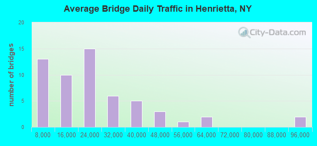
- 1,333,177Total average daily traffic
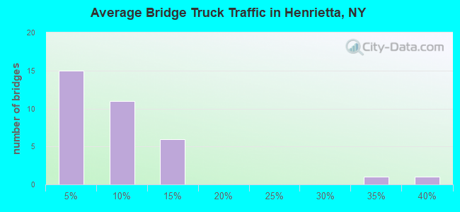
- 44,815Total average daily truck traffic
- National Bridge Inventory (NBI) Registered Bridges for Henrietta
- No street view available for this location
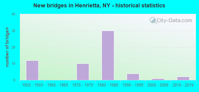
- New bridges - historical statistics
- 121950-1959
- 101970-1979
- 301980-1989
- 41990-1999
- 12000-2009
- 22010-2019
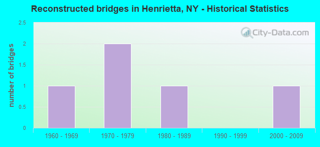
- Reconstructed bridges - Historical Statistics
- 11960-1969
- 21970-1979
- 11980-1989
- 01990-1999
- 12000-2009
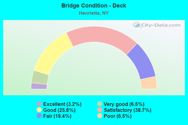
- Bridge Condition - Deck
- 3.2%Excellent
- 6.5%Very good
- 25.8%Good
- 38.7%Satisfactory
- 19.4%Fair
- 6.5%Poor
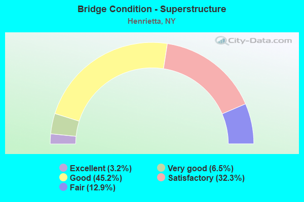
- Bridge Condition - Superstructure
- 3.2%Excellent
- 6.5%Very good
- 45.2%Good
- 32.3%Satisfactory
- 12.9%Fair
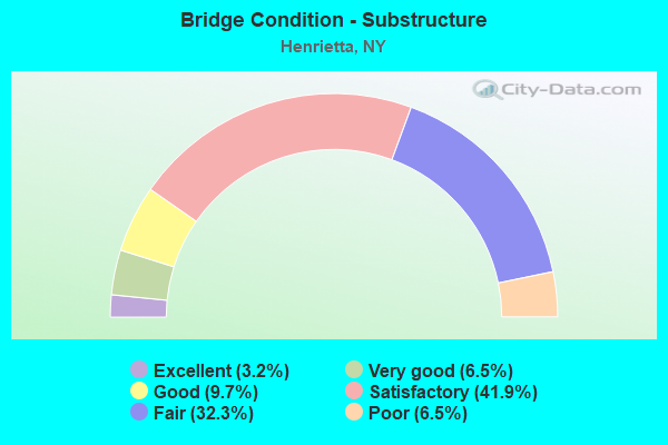
- Bridge Condition - Substructure
- 3.2%Excellent
- 6.5%Very good
- 9.7%Good
- 41.9%Satisfactory
- 32.3%Fair
- 6.5%Poor
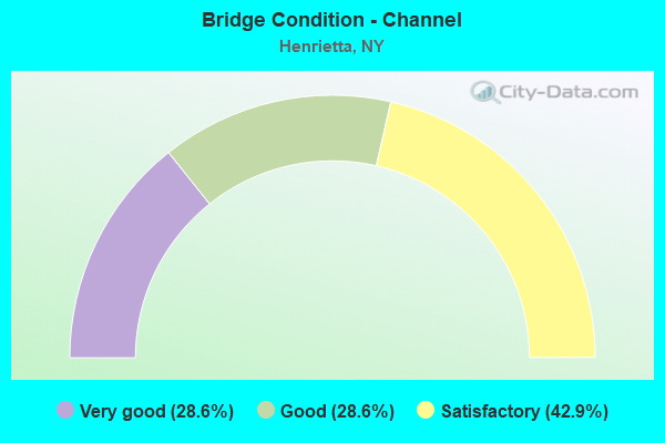
- Bridge Condition - Channel
- 28.6%Very good
- 28.6%Good
- 42.9%Satisfactory
Find on map >> Show street view
Structure Number: 101153, Location: JCT RTS 15&NYS THRUWAY (Lat: 43.047508, Lng: -77.658031), Route carried "on" structure: State highway 15, Year Built: 1953, Year Reconstructed: 1985, Status: Open, Structure Length: 7.86m (25.79ft), Average Daily Traffic: 16,722 (year 2019), Truck Traffic: 3%, Average Future Daily Traffic: 20,313 (year 2040), Design Load: H 20, Features Intersected: 90IX EB, RTE I90
Minimum Vertical Clearance: 30+ m (98+ ft), Kilometerpoint: 12.679, Lanes on structure: 4, Lanes under structure: 6, Base Highway Network: Yes, Owner: State Toll Authority, Approaching Roadway Width: 19.5m (64.0ft), Skew: 2 degrees, Material/Design: Steel, Design/Construction: Stringer/Multi-beam, Number Of Spans In Main Unit: 4, Length of Maximum Span: 23.5m (77.1ft), Curb-To-Curb Width: 19.2m (63.0ft), Out-to-Out Width: 20.1m (65.9ft)
Condition: Deck: Fair, Superstructure: Satisfactory, Substructure: Poor, Operating Rating: 68.9 metric tons, Method Used To Determine Operating Rating: Load Factor (LF), Inventory Rating: 40.8 metric tons, Method Used To Determine Inventory Rating: Load Factor (LF), Structural Evaluation: Meets minimum limits, Deck Geometry: Equal to present minimum criteria, Underclear: High priority of corrective action, Approach Roadway Alignment: Equal to present desirable criteria, Length Of Structure Improvement: 7.86m (25.79ft), Designated Inspection Frequency: Every 24 months, Inspection Date: May 2021, Bridge Improvement Cost: $3,874,000, Roadway Improvement Cost: $2,268,000, Total Project Cost: $6,142,000 ( Estimate for 2021), Deck Structure Type: Concrete Cast-file-Place, Wearing Surface/Protective System: Wearing Surface: Integral Concrete, Deck Protection: Epoxy Coated Reinforcing
Find on map >> Show street view
Structure Number: 101154, Location: 1 MI S JCT RTS 15& 252 (Lat: 43.083664, Lng: -77.638678), Route carried "on" structure: State highway 15, Year Built: 1994, Status: Open, Structure Length: 1.80m (5.91ft), Average Daily Traffic: 16,341 (year 2020), Truck Traffic: 4%, Average Future Daily Traffic: 19,851 (year 2040), Design Load: HS 25 or greater, Features Intersected: RED CREEK
Minimum Vertical Clearance: 30+ m (98+ ft), Kilometerpoint: 16.943, Lanes on structure: 5, Base Highway Network: Yes, Owner: State Highway Agency, Approaching Roadway Width: 20.7m (67.9ft), Skew: 20 degrees, Material/Design: Prestressed concrete, Design/Construction: Box Beam or Girders - Multiple, Number Of Spans In Main Unit: 1, Length of Maximum Span: 17.6m (57.7ft), Curb or Sidewalk Widths: Left: 1.5m (4.9ft), Right: 1.5m (4.9ft), Curb-To-Curb Width: 20.7m (67.9ft), Out-to-Out Width: 24.4m (80.1ft)
Condition: Deck: Very good, Superstructure: Very good, Substructure: Very good, Channel: Good, Operating Rating: 99.8 metric tons, Method Used To Determine Operating Rating: Load Factor (LF), Inventory Rating: 60.8 metric tons, Method Used To Determine Inventory Rating: Load Factor (LF), Structural Evaluation: Equal to present desirable criteria, Deck Geometry: Somewhat better than minimum adequacy, Waterway Adequacy: Equal to present minimum criteria, Approach Roadway Alignment: Equal to present desirable criteria, Length Of Structure Improvement: 1.79m (5.87ft), Designated Inspection Frequency: Every 24 months, Inspection Date: April 2020, Bridge Improvement Cost: $930,000, Roadway Improvement Cost: $545,000, Total Project Cost: $1,475,000 ( Estimate for 2021), Deck Structure Type: Concrete Cast-file-Place, Wearing Surface/Protective System: Wearing Surface: Bituminous, Membrane: Preformed Fabric, Deck Protection: Epoxy Coated Reinforcing
Find on map >> Show street view
Structure Number: 101162, Location: JCT RTS 15A &NYS THRUWAY (Lat: 43.047064, Lng: -77.618997), Route carried "on" structure: Alternate State highway 15A, Year Built: 1991, Status: Open, Structure Length: 8.90m (29.20ft), Average Daily Traffic: 3,978 (year 2020), Truck Traffic: 6%, Average Future Daily Traffic: 4,832 (year 2040), Design Load: HS 20, Features Intersected: 90IX, RTE I90
Minimum Vertical Clearance: 30+ m (98+ ft), Kilometerpoint: 13.371, Lanes on structure: 2, Lanes under structure: 4, Base Highway Network: Yes, Owner: State Toll Authority, Approaching Roadway Width: 13.4m (44.0ft), Skew: 1 degrees, Material/Design: Steel continuous, Design/Construction: Stringer/Multi-beam, Number Of Spans In Main Unit: 2, Length of Maximum Span: 44.1m (144.7ft), Curb-To-Curb Width: 13.2m (43.3ft), Out-to-Out Width: 14.2m (46.6ft)
Condition: Deck: Satisfactory, Superstructure: Good, Substructure: Good, Operating Rating: 55.3 metric tons, Method Used To Determine Operating Rating: Load Factor (LF), Inventory Rating: 34.5 metric tons, Method Used To Determine Inventory Rating: Load Factor (LF), Structural Evaluation: Better than present minimum criteria, Deck Geometry: Equal to present minimum criteria, Underclear: Somewhat better than minimum adequacy, Approach Roadway Alignment: Equal to present desirable criteria, Length Of Structure Improvement: 8.90m (29.20ft), Designated Inspection Frequency: Every 24 months, Inspection Date: October 2020, Bridge Improvement Cost: $3,132,000, Roadway Improvement Cost: $1,834,000, Total Project Cost: $4,966,000 ( Estimate for 2021), Deck Structure Type: Concrete Cast-file-Place, Wearing Surface/Protective System: Wearing Surface: Integral Concrete, Deck Protection: Epoxy Coated Reinforcing
Find on map >> Show street view
Structure Number: 104342, Location: 0.8MI W JCT RTS 252 15 (Lat: 43.092358, Lng: -77.651900), Route carried "on" structure: State highway 252, Year Built: 1971, Status: Open, Structure Length: 1.77m (5.81ft), Average Daily Traffic: 17,270 (year 2018), Truck Traffic: 4%, Average Future Daily Traffic: 17,351 (year 2040), Design Load: HS 20, Features Intersected: RED CREEK
Minimum Vertical Clearance: 30+ m (98+ ft), Kilometerpoint: 9.783, Lanes on structure: 4, Base Highway Network: Yes, Owner: State Highway Agency, Approaching Roadway Width: 20.1m (65.9ft), Skew: 20 degrees, Material/Design: Steel, Design/Construction: Stringer/Multi-beam, Number Of Spans In Main Unit: 1, Length of Maximum Span: 16.1m (52.8ft), Curb or Sidewalk Widths: Left: 1.5m (4.9ft), Right: 1.5m (4.9ft), Curb-To-Curb Width: 20.1m (65.9ft), Out-to-Out Width: 23.8m (78.1ft)
Condition: Deck: Fair, Superstructure: Good, Substructure: Satisfactory, Channel: Satisfactory, Operating Rating: 84.4 metric tons, Method Used To Determine Operating Rating: Load Factor (LF), Inventory Rating: 49.9 metric tons, Method Used To Determine Inventory Rating: Load Factor (LF), Structural Evaluation: Equal to present minimum criteria, Deck Geometry: Better than present minimum criteria, Waterway Adequacy: Equal to present minimum criteria, Approach Roadway Alignment: Equal to present minimum criteria, Length Of Structure Improvement: 1.76m (5.77ft), Designated Inspection Frequency: Every 24 months, Inspection Date: April 2021, Bridge Improvement Cost: $2,275,000, Roadway Improvement Cost: $1,332,000, Total Project Cost: $3,608,000 ( Estimate for 2021), Deck Structure Type: Concrete Cast-file-Place, Wearing Surface/Protective System: Wearing Surface: Latex Concrete, Deck Protection: Other Coated Reinforcing
Find on map >> Show street view
Structure Number: 1063789, Location: JCT RTS 15 + 252 (Lat: 43.088036, Lng: -77.636308), Route carried "on" structure: State highway 252, Year Built: 1970, Status: Open, Structure Length: 8.56m (28.08ft), Average Daily Traffic: 25,980 (year 2018), Truck Traffic: 4%, Average Future Daily Traffic: 26,102 (year 2040), Design Load: HS 20, Features Intersected: East Loop, West Loop, RT
Minimum Vertical Clearance: 30+ m (98+ ft), Kilometerpoint: 11.102, Lanes on structure: 4, Lanes under structure: 8, Base Highway Network: Yes, Owner: State Highway Agency, Approaching Roadway Width: 15.8m (51.8ft), Skew: 20 degrees, Material/Design: Steel, Design/Construction: Stringer/Multi-beam, Number Of Spans In Main Unit: 3, Length of Maximum Span: 33.2m (108.9ft), Curb or Sidewalk Widths: Left: 0.8m (2.6ft), Right: 0.8m (2.6ft), Curb-To-Curb Width: 15.8m (51.8ft), Out-to-Out Width: 22.3m (73.2ft)
Condition: Deck: Satisfactory, Superstructure: Satisfactory, Substructure: Poor, Operating Rating: 72.6 metric tons, Method Used To Determine Operating Rating: Load Factor (LF), Inventory Rating: 43.5 metric tons, Method Used To Determine Inventory Rating: Load Factor (LF), Structural Evaluation: Meets minimum limits, Deck Geometry: Meets minimum limits, Underclear: Equal to present minimum criteria, Approach Roadway Alignment: Equal to present minimum criteria, Length Of Structure Improvement: 8.56m (28.08ft), Designated Inspection Frequency: Every 24 months, Inspection Date: May 2021, Bridge Improvement Cost: $4,444,000, Roadway Improvement Cost: $2,602,000, Total Project Cost: $7,047,000 ( Estimate for 2021), Deck Structure Type: Concrete Cast-file-Place, Wearing Surface/Protective System: Wearing Surface: Bituminous, Membrane: Other, Deck Protection: Other Coated Reinforcing
Find on map >> Show street view
Structure Number: 106907, Location: 2MI SE JCT RTS 15&I-90 (Lat: 43.026717, Lng: -77.656133), Route carried "on" structure: Other road , Year Built: 1977, Status: Open, Structure Length: 9.08m (29.79ft), Average Daily Traffic: 1,495 (year 2016), Truck Traffic: 5%, Average Future Daily Traffic: 2,093 (year 2036), Design Load: HS 20, Features Intersected: 390I390I43031065, RTE I3, Facility Carried by Structure: MARTIN ROAD
Minimum Vertical Clearance: 30+ m (98+ ft), Kilometerpoint: 4.859, Lanes on structure: 2, Lanes under structure: 7, Owner: State Highway Agency, Approaching Roadway Width: 9.8m (32.2ft), Material/Design: Steel continuous, Design/Construction: Stringer/Multi-beam, Number Of Spans In Main Unit: 2, Length of Maximum Span: 44.8m (147.0ft), Curb or Sidewalk Widths: Left: 1.2m (3.9ft), Right: 1.2m (3.9ft), Curb-To-Curb Width: 14.6m (47.9ft), Out-to-Out Width: 17.8m (58.4ft)
Condition: Deck: Satisfactory, Superstructure: Good, Substructure: Good, Operating Rating: 78.0 metric tons, Method Used To Determine Operating Rating: Load Factor (LF), Inventory Rating: 47.2 metric tons, Method Used To Determine Inventory Rating: Load Factor (LF), Structural Evaluation: Better than present minimum criteria, Deck Geometry: Superior to present desirable criteria, Underclear: Equal to present minimum criteria, Approach Roadway Alignment: Equal to present desirable criteria, Length Of Structure Improvement: 9.08m (29.79ft), Designated Inspection Frequency: Every 24 months, Inspection Date: June 2020, Bridge Improvement Cost: $3,895,000, Roadway Improvement Cost: $2,281,000, Total Project Cost: $6,175,000 ( Estimate for 2021), Deck Structure Type: Concrete Cast-file-Place, Wearing Surface/Protective System: Wearing Surface: Integral Concrete
Find on map >> Show street view
Structure Number: 106908, Location: ERIE STA RD OVER GEN EXPW (Lat: 43.040531, Lng: -77.651511), Route carried "on" structure: County highway , Year Built: 1976, Status: Open, Structure Length: 8.41m (27.59ft), Average Daily Traffic: 2,804 (year 2017), Truck Traffic: 2%, Average Future Daily Traffic: 3,406 (year 2040), Design Load: HS 20, Features Intersected: 390I390I43031075, RTE I3, Facility Carried by Structure: ERIE STATION ROAD
Minimum Vertical Clearance: 30+ m (98+ ft), Kilometerpoint: 0.821, Lanes on structure: 2, Lanes under structure: 4, Owner: State Highway Agency, Approaching Roadway Width: 14.3m (46.9ft), Skew: 2 degrees, Material/Design: Steel continuous, Design/Construction: Stringer/Multi-beam, Number Of Spans In Main Unit: 2, Length of Maximum Span: 41.4m (135.8ft), Curb-To-Curb Width: 14.3m (46.9ft), Out-to-Out Width: 15.2m (49.9ft)
Condition: Deck: Good, Superstructure: Satisfactory, Substructure: Satisfactory, Operating Rating: 61.6 metric tons, Method Used To Determine Operating Rating: Load and Resistance Factor Rating (LRFR) rating reported by rating factor(RF) method using HL-93 loadings, Inventory Rating: 47.6 metric tons, Method Used To Determine Inventory Rating: Load and Resistance Factor Rating (LRFR) rating reported by rating factor(RF) method using HL-93 loadings, Structural Evaluation: Equal to present minimum criteria, Deck Geometry: Superior to present desirable criteria, Underclear: Equal to present minimum criteria, Approach Roadway Alignment: Equal to present desirable criteria, Length Of Structure Improvement: 8.41m (27.59ft), Designated Inspection Frequency: Every 24 months, Inspection Date: July 2020, Bridge Improvement Cost: $3,124,000, Roadway Improvement Cost: $1,830,000, Total Project Cost: $4,954,000 ( Estimate for 2021), Deck Structure Type: Concrete Cast-file-Place, Wearing Surface/Protective System: Wearing Surface: Bituminous
Find on map >> Show street view
Structure Number: 107004, Location: 1.5 MI N JCT.RTS 390I&253 (Lat: 43.076147, Lng: -77.626828), Route carried "on" structure: County highway , Year Built: 1980, Status: Open, Structure Length: 6.13m (20.11ft), Average Daily Traffic: 12,046 (year 2020), Truck Traffic: 2%, Average Future Daily Traffic: 12,102 (year 2040), Design Load: HS 20+Mod, Features Intersected: 390I390I43031103SB, RTE, Facility Carried by Structure: HYLAN DRIVE
Minimum Vertical Clearance: 30+ m (98+ ft), Kilometerpoint: 0.885, Lanes on structure: 5, Lanes under structure: 7, Owner: State Highway Agency, Approaching Roadway Width: 15.2m (49.9ft), Material/Design: Steel, Design/Construction: Stringer/Multi-beam, Number Of Spans In Main Unit: 2, Length of Maximum Span: 30.1m (98.8ft), Curb or Sidewalk Widths: Left: 1.5m (4.9ft), Right: 1.5m (4.9ft), Curb-To-Curb Width: 19.5m (64.0ft), Out-to-Out Width: 23.2m (76.1ft)
Condition: Deck: Fair, Superstructure: Satisfactory, Substructure: Satisfactory, Operating Rating: 83.6 metric tons, Method Used To Determine Operating Rating: Load and Resistance Factor Rating (LRFR) rating reported by rating factor(RF) method using HL-93 loadings, Inventory Rating: 64.5 metric tons, Method Used To Determine Inventory Rating: Load and Resistance Factor Rating (LRFR) rating reported by rating factor(RF) method using HL-93 loadings, Structural Evaluation: Equal to present minimum criteria, Deck Geometry: Meets minimum limits, Underclear: High priority of corrective action, Approach Roadway Alignment: Equal to present desirable criteria, Length Of Structure Improvement: 6.12m (20.08ft), Designated Inspection Frequency: Every 24 months, Inspection Date: August 2021, Bridge Improvement Cost: $3,976,000, Roadway Improvement Cost: $2,328,000, Total Project Cost: $6,304,000 ( Estimate for 2021), Deck Structure Type: Concrete Cast-file-Place, Wearing Surface/Protective System: Wearing Surface: Integral Concrete, Deck Protection: Epoxy Coated Reinforcing
Find on map >> Show street view
Structure Number: 1070051, Location: 1.1 MI N JCT I390 & SH253 (Lat: 43.072700, Lng: -77.632328), Route carried "on" structure: Interstate 390, Year Built: 1980, Status: Open, Structure Length: 8.53m (27.99ft), Average Daily Traffic: 31,059 (year 2015), Truck Traffic: 10%, Design Load: HS 20+Mod, Features Intersected: LIVONIA AVON LAKEVIEW RR
Minimum Vertical Clearance: 30+ m (98+ ft), Kilometerpoint: 15.977, Lanes on structure: 3, Base Highway Network: Yes, Owner: State Highway Agency, Approaching Roadway Width: 14.3m (46.9ft), Skew: 2 degrees, Material/Design: Prestressed concrete, Design/Construction: Box Beam or Girders - Multiple, Number Of Spans In Main Unit: 4, Length of Maximum Span: 25.9m (85.0ft), Curb-To-Curb Width: 18.1m (59.4ft), Out-to-Out Width: 19.2m (63.0ft)
Condition: Deck: Satisfactory, Superstructure: Satisfactory, Substructure: Satisfactory, Channel: Good, Operating Rating: 63.5 metric tons, Method Used To Determine Operating Rating: Load and Resistance Factor Rating (LRFR) rating reported by rating factor(RF) method using HL-93 loadings, Inventory Rating: 19.1 metric tons, Method Used To Determine Inventory Rating: Load and Resistance Factor Rating (LRFR) rating reported by rating factor(RF) method using HL-93 loadings, Structural Evaluation: Meets minimum limits, Deck Geometry: Better than present minimum criteria, Underclear: Somewhat better than minimum adequacy, Waterway Adequacy: Superior to present desirable criteria, Approach Roadway Alignment: Equal to present desirable criteria, Length Of Structure Improvement: 8.53m (27.99ft), Designated Inspection Frequency: Every 24 months, Inspection Date: August 2021, Bridge Improvement Cost: $3,407,000, Roadway Improvement Cost: $1,995,000, Total Project Cost: $5,403,000 ( Estimate for 2021), Deck Structure Type: Concrete Cast-file-Place, Wearing Surface/Protective System: Wearing Surface: Bituminous, Membrane: Preformed Fabric
Find on map >> Show street view
Structure Number: 1070052, Location: 1.1 MI N JCT I390 & SH253 (Lat: 43.072478, Lng: -77.632056), Route carried "on" structure: Interstate 390, Year Built: 1980, Status: Open, Structure Length: 8.53m (27.99ft), Average Daily Traffic: 19,100 (year 2018), Truck Traffic: 7%, Average Future Daily Traffic: 26,561 (year 2040), Design Load: HS 20+Mod, Features Intersected: LIVONIA AVON LAKEVIEW RR
Minimum Vertical Clearance: 30+ m (98+ ft), Kilometerpoint: 15.945, Lanes on structure: 3, Base Highway Network: Yes, Owner: State Highway Agency, Approaching Roadway Width: 16.2m (53.1ft), Skew: 2 degrees, Material/Design: Prestressed concrete, Design/Construction: Box Beam or Girders - Multiple, Number Of Spans In Main Unit: 4, Length of Maximum Span: 25.9m (85.0ft), Curb-To-Curb Width: 16.2m (53.1ft), Out-to-Out Width: 17.2m (56.4ft)
Condition: Deck: Satisfactory, Superstructure: Good, Substructure: Satisfactory, Channel: Very good, Operating Rating: 73.5 metric tons, Method Used To Determine Operating Rating: Load Factor (LF), Inventory Rating: 38.1 metric tons, Method Used To Determine Inventory Rating: Load Factor (LF), Structural Evaluation: Equal to present minimum criteria, Deck Geometry: Equal to present minimum criteria, Underclear: Somewhat better than minimum adequacy, Waterway Adequacy: Equal to present minimum criteria, Approach Roadway Alignment: Equal to present desirable criteria, Length Of Structure Improvement: 8.53m (27.99ft), Designated Inspection Frequency: Every 24 months, Inspection Date: August 2021, Bridge Improvement Cost: $3,056,000, Roadway Improvement Cost: $1,789,000, Total Project Cost: $4,845,000 ( Estimate for 2021), Deck Structure Type: Concrete Cast-file-Place, Wearing Surface/Protective System: Wearing Surface: Bituminous, Membrane: Preformed Fabric
Find on map >> Show street view
Structure Number: 1070061, Location: .7 MI N JCT I390 & SH 253 (Lat: 43.068164, Lng: -77.636644), Route carried "on" structure: Interstate 390, Year Built: 1980, Status: Open, Structure Length: 4.91m (16.11ft), Average Daily Traffic: 31,059 (year 2015), Truck Traffic: 10%, Design Load: HS 20+Mod, Features Intersected: CALKINS RD-CR 39
Minimum Vertical Clearance: 30+ m (98+ ft), Kilometerpoint: 15.414, Lanes on structure: 3, Lanes under structure: 4, Base Highway Network: Yes, Owner: State Highway Agency, Approaching Roadway Width: 16.5m (54.1ft), Skew: 2 degrees, Material/Design: Steel, Design/Construction: Stringer/Multi-beam, Number Of Spans In Main Unit: 3, Length of Maximum Span: 29.0m (95.1ft), Curb-To-Curb Width: 16.2m (53.1ft), Out-to-Out Width: 17.2m (56.4ft)
Condition: Deck: Fair, Superstructure: Good, Substructure: Fair, Operating Rating: 69.0 metric tons, Method Used To Determine Operating Rating: Load and Resistance Factor Rating (LRFR) rating reported by rating factor(RF) method using HL-93 loadings, Inventory Rating: 53.5 metric tons, Method Used To Determine Inventory Rating: Load and Resistance Factor Rating (LRFR) rating reported by rating factor(RF) method using HL-93 loadings, Structural Evaluation: Somewhat better than minimum adequacy, Deck Geometry: Equal to present minimum criteria, Underclear: Equal to present minimum criteria, Approach Roadway Alignment: Equal to present desirable criteria, Length Of Structure Improvement: 4.90m (16.08ft), Designated Inspection Frequency: Every 24 months, Inspection Date: May 2021, Bridge Improvement Cost: $2,175,000, Roadway Improvement Cost: $1,274,000, Total Project Cost: $3,449,000 ( Estimate for 2021), Deck Structure Type: Concrete Cast-file-Place, Wearing Surface/Protective System: Wearing Surface: Monolithic Concrete, Deck Protection: Epoxy Coated Reinforcing
Find on map >> Show street view
Structure Number: 1070062, Location: .7 MI N JCT I390 & SH 253 (Lat: 43.068178, Lng: -77.636239), Route carried "on" structure: Interstate 390, Year Built: 1980, Status: Open, Structure Length: 4.91m (16.11ft), Average Daily Traffic: 19,100 (year 2018), Truck Traffic: 7%, Average Future Daily Traffic: 26,561 (year 2040), Design Load: HS 20+Mod, Features Intersected: CALKINS RD-CR 39
Minimum Vertical Clearance: 30+ m (98+ ft), Kilometerpoint: 15.350, Lanes on structure: 3, Lanes under structure: 4, Base Highway Network: Yes, Owner: State Highway Agency, Approaching Roadway Width: 16.5m (54.1ft), Skew: 2 degrees, Material/Design: Steel, Design/Construction: Stringer/Multi-beam, Number Of Spans In Main Unit: 3, Length of Maximum Span: 27.7m (90.9ft), Curb-To-Curb Width: 16.2m (53.1ft), Out-to-Out Width: 17.2m (56.4ft)
Condition: Deck: Good, Superstructure: Good, Substructure: Satisfactory, Operating Rating: 69.0 metric tons, Method Used To Determine Operating Rating: Load and Resistance Factor Rating (LRFR) rating reported by rating factor(RF) method using HL-93 loadings, Inventory Rating: 53.5 metric tons, Method Used To Determine Inventory Rating: Load and Resistance Factor Rating (LRFR) rating reported by rating factor(RF) method using HL-93 loadings, Structural Evaluation: Equal to present minimum criteria, Deck Geometry: Equal to present minimum criteria, Underclear: Equal to present minimum criteria, Approach Roadway Alignment: Equal to present desirable criteria, Length Of Structure Improvement: 4.90m (16.08ft), Designated Inspection Frequency: Every 24 months, Inspection Date: May 2021, Bridge Improvement Cost: $2,175,000, Roadway Improvement Cost: $1,274,000, Total Project Cost: $3,449,000 ( Estimate for 2021), Deck Structure Type: Concrete Cast-file-Place, Wearing Surface/Protective System: Wearing Surface: Monolithic Concrete, Deck Protection: Epoxy Coated Reinforcing
Find on map >> Show street view
Structure Number: 1070071, Location: JCT OF RTS 390I & 253 (Lat: 43.058831, Lng: -77.641783), Route carried "on" structure: Interstate 390, Year Built: 1980, Status: Open, Structure Length: 5.06m (16.60ft), Average Daily Traffic: 31,059 (year 2015), Truck Traffic: 11%, Design Load: HS 20+Mod, Features Intersected: RTE 253
Minimum Vertical Clearance: 30+ m (98+ ft), Kilometerpoint: 14.288, Lanes on structure: 4, Lanes under structure: 6, Base Highway Network: Yes, Owner: State Highway Agency, Approaching Roadway Width: 18.0m (59.1ft), Skew: 2 degrees, Material/Design: Steel, Design/Construction: Stringer/Multi-beam, Number Of Spans In Main Unit: 3, Length of Maximum Span: 29.8m (97.8ft), Curb-To-Curb Width: 18.1m (59.4ft), Out-to-Out Width: 19.2m (63.0ft)
Condition: Deck: Good, Superstructure: Fair, Substructure: Fair, Inventory Rating: 63.5 metric tons, Method Used To Determine Inventory Rating: Load Factor (LF), Structural Evaluation: Somewhat better than minimum adequacy, Deck Geometry: Meets minimum limits, Underclear: High priority of corrective action, Approach Roadway Alignment: Equal to present desirable criteria, Length Of Structure Improvement: 5.05m (16.57ft), Designated Inspection Frequency: Every 24 months, Inspection Date: November 2021, Bridge Improvement Cost: $2,564,000, Roadway Improvement Cost: $1,501,000, Total Project Cost: $4,065,000 ( Estimate for 2021), Deck Structure Type: Concrete Cast-file-Place, Wearing Surface/Protective System: Wearing Surface: Integral Concrete, Deck Protection: Epoxy Coated Reinforcing
Find on map >> Show street view
Structure Number: 1070072, Location: JCT OF RTS 390I & 253 (Lat: 43.058858, Lng: -77.641325), Route carried "on" structure: Interstate 390, Year Built: 1980, Status: Open, Structure Length: 5.06m (16.60ft), Average Daily Traffic: 19,100 (year 2018), Truck Traffic: 7%, Average Future Daily Traffic: 26,561 (year 2040), Design Load: HS 20+Mod, Features Intersected: RTE 253
Minimum Vertical Clearance: 30+ m (98+ ft), Kilometerpoint: 14.240, Lanes on structure: 2, Lanes under structure: 6, Base Highway Network: Yes, Owner: State Highway Agency, Approaching Roadway Width: 12.5m (41.0ft), Skew: 2 degrees, Material/Design: Steel, Design/Construction: Stringer/Multi-beam, Number Of Spans In Main Unit: 3, Length of Maximum Span: 29.8m (97.8ft), Curb-To-Curb Width: 12.5m (41.0ft), Out-to-Out Width: 13.6m (44.6ft)
Condition: Deck: Good, Superstructure: Good, Substructure: Fair, Inventory Rating: 64.4 metric tons, Method Used To Determine Inventory Rating: Load Factor (LF), Structural Evaluation: Somewhat better than minimum adequacy, Deck Geometry: Better than present minimum criteria, Underclear: High priority of corrective action, Approach Roadway Alignment: Equal to present desirable criteria, Length Of Structure Improvement: 5.05m (16.57ft), Designated Inspection Frequency: Every 24 months, Inspection Date: October 2021, Bridge Improvement Cost: $1,809,000, Roadway Improvement Cost: $1,060,000, Total Project Cost: $2,869,000 ( Estimate for 2021), Deck Structure Type: Concrete Cast-file-Place, Wearing Surface/Protective System: Wearing Surface: Integral Concrete, Deck Protection: Epoxy Coated Reinforcing
Find on map >> Show street view
Structure Number: 1070089, Location: .3 MI N JCT I390 & I90 (Lat: 43.052592, Lng: -77.646650), Route carried "on" structure: Ramp Interstate , Year Built: 1980, Status: Open, Structure Length: 11.34m (37.20ft), Average Daily Traffic: 6,990 (year 2020), Truck Traffic: 11%, Average Future Daily Traffic: 9,720 (year 2040), Design Load: HS 20+Mod, Features Intersected: 3901390143031083, RTE I3, Facility Carried by Structure: RAMP TO THRUWAY
Minimum Vertical Clearance: 30+ m (98+ ft), Kilometerpoint: 0.370, Lanes on structure: 2, Lanes under structure: 8, Owner: State Highway Agency, Approaching Roadway Width: 15.5m (50.9ft), Skew: 20 degrees, Material/Design: Steel, Design/Construction: Stringer/Multi-beam, Number Of Spans In Main Unit: 4, Length of Maximum Span: 30.4m (99.7ft), Curb-To-Curb Width: 15.2m (49.9ft), Out-to-Out Width: 16.2m (53.1ft)
Condition: Deck: Satisfactory, Superstructure: Good, Substructure: Satisfactory, Operating Rating: 82.6 metric tons, Method Used To Determine Operating Rating: Load Factor (LF), Inventory Rating: 49.9 metric tons, Method Used To Determine Inventory Rating: Load Factor (LF), Structural Evaluation: Equal to present minimum criteria, Deck Geometry: Superior to present desirable criteria, Underclear: High priority of corrective action, Approach Roadway Alignment: Equal to present desirable criteria, Length Of Structure Improvement: 11.33m (37.17ft), Designated Inspection Frequency: Every 24 months, Inspection Date: November 2020, Bridge Improvement Cost: $4,226,000, Roadway Improvement Cost: $2,475,000, Total Project Cost: $6,701,000 ( Estimate for 2021), Deck Structure Type: Concrete Cast-file-Place, Wearing Surface/Protective System: Wearing Surface: Integral Concrete, Deck Protection: Epoxy Coated Reinforcing
Find on map >> Show street view
Structure Number: 1070091, Location: IN WEST HENRIETTA (Lat: 43.047781, Lng: -77.648444), Route carried "on" structure: Interstate 390, Year Built: 1980, Status: Open, Structure Length: 6.22m (20.41ft), Average Daily Traffic: 19,703 (year 2006), Truck Traffic: 11%, Design Load: HS 20+Mod, Features Intersected: 90I 90I00003623 WB, RTE
Minimum Vertical Clearance: 30+ m (98+ ft), Kilometerpoint: 12.936, Lanes on structure: 2, Lanes under structure: 6, Base Highway Network: Yes, Owner: State Highway Agency, Approaching Roadway Width: 12.5m (41.0ft), Skew: 1 degrees, Material/Design: Steel, Design/Construction: Stringer/Multi-beam, Number Of Spans In Main Unit: 2, Length of Maximum Span: 30.4m (99.7ft), Curb-To-Curb Width: 12.5m (41.0ft), Out-to-Out Width: 13.4m (44.0ft)
Condition: Deck: Satisfactory, Superstructure: Satisfactory, Substructure: Fair, Operating Rating: 70.6 metric tons, Method Used To Determine Operating Rating: Load and Resistance Factor Rating (LRFR) rating reported by rating factor(RF) method using HL-93 loadings, Inventory Rating: 54.4 metric tons, Method Used To Determine Inventory Rating: Load and Resistance Factor Rating (LRFR) rating reported by rating factor(RF) method using HL-93 loadings, Structural Evaluation: Somewhat better than minimum adequacy, Deck Geometry: Better than present minimum criteria, Underclear: Equal to present minimum criteria, Approach Roadway Alignment: Equal to present desirable criteria, Length Of Structure Improvement: 6.21m (20.37ft), Designated Inspection Frequency: Every 24 months, Inspection Date: October 2021, Bridge Improvement Cost: $2,404,000, Roadway Improvement Cost: $1,408,000, Total Project Cost: $3,812,000 ( Estimate for 2021), Deck Structure Type: Concrete Cast-file-Place, Wearing Surface/Protective System: Wearing Surface: Integral Concrete, Deck Protection: Epoxy Coated Reinforcing
Find on map >> Show street view
Structure Number: 1070092, Location: IN WEST HENRIETTA (Lat: 43.048011, Lng: -77.647914), Route carried "on" structure: Interstate 390, Year Built: 1980, Status: Open, Structure Length: 6.22m (20.41ft), Average Daily Traffic: 12,365 (year 2018), Truck Traffic: 9%, Average Future Daily Traffic: 17,195 (year 2040), Design Load: HS 20+Mod, Features Intersected: 90I 90I00003623 WB, RTE
Minimum Vertical Clearance: 30+ m (98+ ft), Kilometerpoint: 12.904, Lanes on structure: 3, Lanes under structure: 6, Base Highway Network: Yes, Owner: State Highway Agency, Approaching Roadway Width: 14.3m (46.9ft), Skew: 1 degrees, Material/Design: Steel, Design/Construction: Stringer/Multi-beam, Number Of Spans In Main Unit: 2, Length of Maximum Span: 30.4m (99.7ft), Curb-To-Curb Width: 14.5m (47.6ft), Out-to-Out Width: 15.4m (50.5ft)
Condition: Deck: Satisfactory, Superstructure: Good, Substructure: Fair, Inventory Rating: 65.3 metric tons, Method Used To Determine Inventory Rating: Load Factor (LF), Structural Evaluation: Somewhat better than minimum adequacy, Deck Geometry: Meets minimum limits, Underclear: Equal to present minimum criteria, Approach Roadway Alignment: Equal to present desirable criteria, Length Of Structure Improvement: 6.21m (20.37ft), Designated Inspection Frequency: Every 24 months, Inspection Date: October 2021, Bridge Improvement Cost: $2,719,000, Roadway Improvement Cost: $1,592,000, Total Project Cost: $4,311,000 ( Estimate for 2021), Deck Structure Type: Concrete Cast-file-Place, Wearing Surface/Protective System: Wearing Surface: Integral Concrete, Deck Protection: Epoxy Coated Reinforcing
Find on map >> Show street view
Structure Number: 107079, Location: 0.5 MI N JCT RTS 252&390I (Lat: 43.095183, Lng: -77.602069), Route carried "on" structure: County highway , Year Built: 1981, Status: Open, Structure Length: 7.28m (23.88ft), Average Daily Traffic: 14,290 (year 2020), Truck Traffic: 3%, Average Future Daily Traffic: 17,359 (year 2040), Design Load: HS 20, Features Intersected: 390I390I43031123, RTE I3, Facility Carried by Structure: BRIGH/HENR-T L RD
Minimum Vertical Clearance: 30+ m (98+ ft), Kilometerpoint: 4.216, Lanes on structure: 4, Lanes under structure: 8, Owner: State Highway Agency, Approaching Roadway Width: 16.5m (54.1ft), Skew: 21 degrees, Material/Design: Steel, Design/Construction: Stringer/Multi-beam, Number Of Spans In Main Unit: 2, Length of Maximum Span: 35.6m (116.8ft), Curb or Sidewalk Widths: Left: 1.9m (6.2ft), Right: 1.9m (6.2ft), Curb-To-Curb Width: 16.5m (54.1ft), Out-to-Out Width: 20.3m (66.6ft)
Condition: Deck: Good, Superstructure: Good, Substructure: Fair, Operating Rating: 91.6 metric tons, Method Used To Determine Operating Rating: Load Factor (LF), Inventory Rating: 54.4 metric tons, Method Used To Determine Inventory Rating: Load Factor (LF), Structural Evaluation: Somewhat better than minimum adequacy, Deck Geometry: Meets minimum limits, Underclear: High priority of corrective action, Approach Roadway Alignment: Equal to present desirable criteria, Length Of Structure Improvement: 7.28m (23.88ft), Designated Inspection Frequency: Every 24 months, Inspection Date: June 2020, Bridge Improvement Cost: $4,146,000, Roadway Improvement Cost: $2,428,000, Total Project Cost: $6,574,000 ( Estimate for 2021), Deck Structure Type: Concrete Cast-file-Place, Wearing Surface/Protective System: Wearing Surface: Integral Concrete, Deck Protection: Epoxy Coated Reinforcing
Find on map >> Show street view
Structure Number: 1070811, Location: JCT OF RTS 252 & 390I (Lat: 43.087189, Lng: -77.605031), Route carried "on" structure: Interstate 390, Year Built: 1981, Status: Open, Structure Length: 4.21m (13.81ft), Average Daily Traffic: 38,350 (year 2006), Truck Traffic: 6%, Design Load: HS 20, Features Intersected: RTE 252
Minimum Vertical Clearance: 30+ m (98+ ft), Kilometerpoint: 18.664, Lanes on structure: 4, Lanes under structure: 7, Base Highway Network: Yes, Owner: State Highway Agency, Approaching Roadway Width: 24.1m (79.1ft), Skew: 22 degrees, Material/Design: Steel, Design/Construction: Stringer/Multi-beam, Number Of Spans In Main Unit: 1, Length of Maximum Span: 40.5m (132.9ft), Curb-To-Curb Width: 25.3m (83.0ft), Out-to-Out Width: 26.2m (86.0ft)
Condition: Deck: Good, Superstructure: Good, Substructure: Fair, Operating Rating: 91.6 metric tons, Method Used To Determine Operating Rating: Load Factor (LF), Inventory Rating: 54.4 metric tons, Method Used To Determine Inventory Rating: Load Factor (LF), Structural Evaluation: Somewhat better than minimum adequacy, Deck Geometry: Superior to present desirable criteria, Underclear: High priority of corrective action, Approach Roadway Alignment: Equal to present desirable criteria, Length Of Structure Improvement: 4.20m (13.78ft), Designated Inspection Frequency: Every 24 months, Inspection Date: September 2021, Bridge Improvement Cost: $3,895,000, Roadway Improvement Cost: $2,281,000, Total Project Cost: $6,176,000 ( Estimate for 2021), Deck Structure Type: Concrete Cast-file-Place, Wearing Surface/Protective System: Wearing Surface: Integral Concrete, Deck Protection: Epoxy Coated Reinforcing
Find on map >> Show street view
Structure Number: 1070812, Location: JCT OF RTS 252 & 390I (Lat: 43.087261, Lng: -77.604500), Route carried "on" structure: Interstate 390, Year Built: 1981, Status: Open, Structure Length: 4.18m (13.71ft), Average Daily Traffic: 30,166 (year 2020), Truck Traffic: 9%, Average Future Daily Traffic: 41,951 (year 2040), Design Load: HS 20, Features Intersected: RTE 252
Minimum Vertical Clearance: 30+ m (98+ ft), Kilometerpoint: 18.761, Lanes on structure: 4, Lanes under structure: 7, Base Highway Network: Yes, Owner: State Highway Agency, Approaching Roadway Width: 24.1m (79.1ft), Skew: 22 degrees, Material/Design: Steel, Design/Construction: Stringer/Multi-beam, Number Of Spans In Main Unit: 1, Length of Maximum Span: 40.2m (131.9ft), Curb-To-Curb Width: 25.3m (83.0ft), Out-to-Out Width: 26.2m (86.0ft)
Condition: Deck: Good, Superstructure: Good, Substructure: Satisfactory, Operating Rating: 85.3 metric tons, Method Used To Determine Operating Rating: Load Factor (LF), Inventory Rating: 50.8 metric tons, Method Used To Determine Inventory Rating: Load Factor (LF), Structural Evaluation: Equal to present minimum criteria, Deck Geometry: Superior to present desirable criteria, Underclear: High priority of corrective action, Approach Roadway Alignment: Equal to present desirable criteria, Length Of Structure Improvement: 4.17m (13.68ft), Designated Inspection Frequency: Every 24 months, Inspection Date: September 2021, Bridge Improvement Cost: $3,756,000, Roadway Improvement Cost: $2,200,000, Total Project Cost: $5,956,000 ( Estimate for 2021), Deck Structure Type: Concrete Cast-file-Place, Wearing Surface/Protective System: Wearing Surface: Integral Concrete, Deck Protection: Epoxy Coated Reinforcing
Find on map >> Show street view
Structure Number: 107082, Location: JCT.OF RTS 15A & 390I (Lat: 43.084050, Lng: -77.607969), Route carried "on" structure: State highway 15A, Year Built: 1981, Status: Open, Structure Length: 6.68m (21.92ft), Average Daily Traffic: 16,481 (year 2018), Truck Traffic: 5%, Average Future Daily Traffic: 20,021 (year 2040), Design Load: HS 20, Features Intersected: 390I390I43031115SB, RTE
Minimum Vertical Clearance: 30+ m (98+ ft), Kilometerpoint: 17.683, Lanes on structure: 5, Lanes under structure: 6, Base Highway Network: Yes, Owner: State Highway Agency, Approaching Roadway Width: 19.5m (64.0ft), Skew: 2 degrees, Material/Design: Steel, Design/Construction: Stringer/Multi-beam, Number Of Spans In Main Unit: 2, Length of Maximum Span: 32.6m (107.0ft), Curb or Sidewalk Widths: Left: 1.9m (6.2ft), Right: 1.9m (6.2ft), Curb-To-Curb Width: 19.5m (64.0ft), Out-to-Out Width: 23.9m (78.4ft)
Condition: Deck: Satisfactory, Superstructure: Satisfactory, Substructure: Good, Operating Rating: 96.2 metric tons, Method Used To Determine Operating Rating: Load Factor (LF), Inventory Rating: 57.2 metric tons, Method Used To Determine Inventory Rating: Load Factor (LF), Structural Evaluation: Equal to present minimum criteria, Deck Geometry: Meets minimum limits, Underclear: High priority of corrective action, Approach Roadway Alignment: Equal to present desirable criteria, Length Of Structure Improvement: 6.67m (21.88ft), Designated Inspection Frequency: Every 24 months, Inspection Date: September 2021, Bridge Improvement Cost: $4,619,000, Roadway Improvement Cost: $2,705,000, Total Project Cost: $7,324,000 ( Estimate for 2021), Deck Structure Type: Concrete Cast-file-Place, Wearing Surface/Protective System: Wearing Surface: Integral Concrete, Deck Protection: Epoxy Coated Reinforcing
Find on map >> Show street view
Structure Number: 107966, Location: Ramp NB 390 to Rte 15 (Lat: 43.110231, Lng: -77.618842), Route carried "on" structure: Ramp Other road , Year Built: 2016, Status: Open, Structure Length: 1.49m (4.89ft), Average Daily Traffic: 3,389 (year 2020), Truck Traffic: 2%, Average Future Daily Traffic: 4,713 (year 2040), Design Load: HL 93, Features Intersected: Ramp DH, Facility Carried by Structure: Ramp NFE
Minimum Vertical Clearance: 32.69m (107.25ft), Kilometerpoint: 0.257, Lanes on structure: 1, Lanes under structure: 1, Owner: State Highway Agency, Approaching Roadway Width: 7.3m (24.0ft), Skew: 4 degrees, Material/Design: Concrete, Design/Construction: Frame, Number Of Spans In Main Unit: 1, Length of Maximum Span: 13.1m (43.0ft), Curb-To-Curb Width: 7.3m (24.0ft), Out-to-Out Width: 8.6m (28.2ft)
Condition: Deck: Excellent, Superstructure: Excellent, Substructure: Excellent, Operating Rating: 81.9 metric tons, Method Used To Determine Operating Rating: Field evaluation and documented engineering judgment, Inventory Rating: 40.8 metric tons, Method Used To Determine Inventory Rating: Field evaluation and documented engineering judgment, Structural Evaluation: Superior to present desirable criteria, Deck Geometry: Better than present minimum criteria, Underclear: Meets minimum limits, Approach Roadway Alignment: Equal to present desirable criteria, Length Of Structure Improvement: 1.49m (4.89ft), Designated Inspection Frequency: Every 24 months, Inspection Date: October 2020, Bridge Improvement Cost: $580,000, Roadway Improvement Cost: $339,000, Total Project Cost: $919,000 ( Estimate for 2021)
Find on map >> Show street view
Structure Number: 227006, Location: IN RIDGELAND (Lat: 43.092558, Lng: -77.614317), Route carried "on" structure: Business Other road , Year Built: 2004, Status: Open, Structure Length: 2.01m (6.59ft), Average Daily Traffic: 10,322 (year 2020), Truck Traffic: 5%, Average Future Daily Traffic: 12,771 (year 2040), Design Load: HS 25 or greater, Features Intersected: CSX TRANS/W SHORE, Facility Carried by Structure: CLAY ROAD
Minimum Vertical Clearance: 30+ m (98+ ft), Kilometerpoint: 1.657, Lanes on structure: 2, Owner: Town or Township Highway Agency, Approaching Roadway Width: 10.1m (33.1ft), Skew: 2 degrees, Material/Design: Steel, Design/Construction: Stringer/Multi-beam, Number Of Spans In Main Unit: 1, Length of Maximum Span: 18.5m (60.7ft), Curb or Sidewalk Widths: Left: 2.0m (6.6ft), Right: 0.0m, Curb-To-Curb Width: 10.1m (33.1ft), Out-to-Out Width: 13.3m (43.6ft)
Condition: Deck: Very good, Superstructure: Very good, Substructure: Very good, Operating Rating: 54.8 metric tons, Method Used To Determine Operating Rating: Load and Resistance Factor Rating (LRFR) rating reported by rating factor(RF) method using HL-93 loadings, Inventory Rating: 42.1 metric tons, Method Used To Determine Inventory Rating: Load and Resistance Factor Rating (LRFR) rating reported by rating factor(RF) method using HL-93 loadings, Structural Evaluation: Equal to present desirable criteria, Deck Geometry: Meets minimum limits, Underclear: Superior to present desirable criteria, Approach Roadway Alignment: Better than present minimum criteria, Length Of Structure Improvement: 2.01m (6.59ft), Designated Inspection Frequency: Every 24 months, Inspection Date: September 2021, Bridge Improvement Cost: $1,265,000, Roadway Improvement Cost: $741,000, Total Project Cost: $2,006,000 ( Estimate for 2021), Deck Structure Type: Concrete Cast-file-Place, Wearing Surface/Protective System: Wearing Surface: Integral Concrete, Deck Protection: Epoxy Coated Reinforcing
Find on map >> Show street view
Structure Number: 33177, Location: 2 MI NE OF 90I EXIT 45 (Lat: 43.068286, Lng: -77.630792), Route carried "on" structure: County highway , Year Built: 1979, Status: Open, Structure Length: 1.22m (4.00ft), Average Daily Traffic: 15,080 (year 2018), Truck Traffic: 2%, Average Future Daily Traffic: 18,319 (year 2040), Design Load: HS 20, Features Intersected: RED CREEK, Facility Carried by Structure: CALKINS ROAD
Minimum Vertical Clearance: 30+ m (98+ ft), Kilometerpoint: 1.319, Lanes on structure: 4, Owner: County Highway Agency, Approaching Roadway Width: 17.7m (58.1ft), Material/Design: Prestressed concrete, Design/Construction: Box Beam or Girders - Multiple, Number Of Spans In Main Unit: 1, Length of Maximum Span: 11.5m (37.7ft), Curb or Sidewalk Widths: Left: 0.9m (3.0ft), Right: 1.8m (5.9ft), Curb-To-Curb Width: 17.7m (58.1ft), Out-to-Out Width: 21.3m (69.9ft)
Condition: Deck: Satisfactory, Superstructure: Satisfactory, Substructure: Satisfactory, Channel: Satisfactory, Operating Rating: 80.8 metric tons, Method Used To Determine Operating Rating: Field evaluation and documented engineering judgment, Inventory Rating: 32.7 metric tons, Method Used To Determine Inventory Rating: Field evaluation and documented engineering judgment, Structural Evaluation: Equal to present minimum criteria, Deck Geometry: Somewhat better than minimum adequacy, Waterway Adequacy: Equal to present desirable criteria, Approach Roadway Alignment: Equal to present desirable criteria, Length Of Structure Improvement: 1.21m (3.97ft), Designated Inspection Frequency: Every 24 months, Inspection Date: May 2020, Bridge Improvement Cost: $1,244,000, Roadway Improvement Cost: $728,000, Total Project Cost: $1,972,000 ( Estimate for 2021), Wearing Surface/Protective System: Wearing Surface: Bituminous, Membrane: Other
Find on map >> Show street view
Structure Number: 336804, Location: IN HENRIETTA (Lat: 43.095658, Lng: -77.588333), Route carried "on" structure: County highway , Year Built: 1993, Status: Open, Structure Length: 0.85m (2.79ft), Average Daily Traffic: 14,290 (year 2020), Truck Traffic: 3%, Average Future Daily Traffic: 17,359 (year 2040), Design Load: HS 20+Mod, Features Intersected: ALLEN CREEK, Facility Carried by Structure: BRIGHTN HEN TL RD
Minimum Vertical Clearance: 30+ m (98+ ft), Kilometerpoint: 5.358, Lanes on structure: 4, Owner: County Highway Agency, Approaching Roadway Width: 13.4m (44.0ft), Skew: 3 degrees, Material/Design: Concrete, Design/Construction: Culvert, Number Of Spans In Main Unit: 2, Length of Maximum Span: 3.9m (12.8ft)
Condition: Channel: Satisfactory, Culverts: Good, Operating Rating: 80.7 metric tons, Method Used To Determine Operating Rating: Load Factor (LF), Inventory Rating: 48.1 metric tons, Method Used To Determine Inventory Rating: Load Factor (LF), Structural Evaluation: Better than present minimum criteria, Waterway Adequacy: Equal to present desirable criteria, Approach Roadway Alignment: Equal to present desirable criteria, Length Of Structure Improvement: 0.85m (2.79ft), Designated Inspection Frequency: Every 24 months, Inspection Date: May 2020, Bridge Improvement Cost: $205,000, Roadway Improvement Cost: $120,000, Total Project Cost: $325,000 ( Estimate for 2021), Wearing Surface/Protective System: Wearing Surface: Bituminous
Find on map >> Show street view
Structure Number: 444308, Location: 1.3 MI W JCT BARGE C & 65 (Lat: 43.095653, Lng: -77.568625), Route carried "on" structure: County highway , Year Built: 1981, Status: Open, Structure Length: 3.72m (12.20ft), Average Daily Traffic: 5,679 (year 2018), Truck Traffic: 1%, Average Future Daily Traffic: 7,026 (year 2040), Design Load: HS 20, Features Intersected: ERIE CANAL, Facility Carried by Structure: EDGEWOOD AVENUE
Minimum Vertical Clearance: 30+ m (98+ ft), Kilometerpoint: 0.998, Lanes on structure: 2, Owner: State Highway Agency, Approaching Roadway Width: 12.2m (40.0ft), Navigation Control: Yes ( Vertical Clearance: 4.8m (15.7ft), Horizontal Clearance: 16.4m (53.8ft)), Material/Design: Steel, Design/Construction: Stringer/Multi-beam, Number Of Spans In Main Unit: 1, Length of Maximum Span: 35.9m (117.8ft), Curb or Sidewalk Widths: Left: 1.5m (4.9ft), Right: 1.5m (4.9ft), Curb-To-Curb Width: 12.2m (40.0ft), Out-to-Out Width: 15.8m (51.8ft)
Condition: Deck: Satisfactory, Superstructure: Good, Substructure: Satisfactory, Channel: Very good, Operating Rating: 95.3 metric tons, Method Used To Determine Operating Rating: Load Factor (LF), Inventory Rating: 56.2 metric tons, Method Used To Determine Inventory Rating: Load Factor (LF), Structural Evaluation: Equal to present minimum criteria, Deck Geometry: Somewhat better than minimum adequacy, Waterway Adequacy: Equal to present minimum criteria, Approach Roadway Alignment: Equal to present desirable criteria, Length Of Structure Improvement: 3.71m (12.17ft), Designated Inspection Frequency: Every 24 months, Inspection Date: May 2020, Bridge Improvement Cost: $1,638,000, Roadway Improvement Cost: $959,000, Total Project Cost: $2,598,000 ( Estimate for 2021), Deck Structure Type: Concrete Cast-file-Place, Wearing Surface/Protective System: Wearing Surface: Integral Concrete, Deck Protection: Epoxy Coated Reinforcing
Find on map >> Show street view
Structure Number: 5510569, Location: 1.2 MI W OF EXIT 46 90I (Lat: 43.044628, Lng: -77.680672), Route carried "on" structure: Interstate 90, Year Built: 1954, Status: Open, Structure Length: 2.16m (7.09ft), Average Daily Traffic: 21,392 (year 2020), Truck Traffic: 35%, Average Future Daily Traffic: 29,749 (year 2040), Design Load: HS 20, Features Intersected: LIVONIA, AVON, AND LAKEV
Minimum Vertical Clearance: 30+ m (98+ ft), Kilometerpoint: 18.616, Lanes on structure: 4, Base Highway Network: Yes, Toll: On Interstate toll segment, Owner: State Toll Authority, Approaching Roadway Width: 25.6m (84.0ft), Skew: 36 degrees, Material/Design: Steel, Design/Construction: Stringer/Multi-beam, Number Of Spans In Main Unit: 1, Length of Maximum Span: 20.1m (65.9ft), Curb-To-Curb Width: 36.6m (120.1ft), Out-to-Out Width: 37.6m (123.4ft)
Condition: Deck: Good, Superstructure: Good, Substructure: Satisfactory, Operating Rating: 56.2 metric tons, Method Used To Determine Operating Rating: Load Factor (LF), Inventory Rating: 35.4 metric tons, Method Used To Determine Inventory Rating: Load Factor (LF), Structural Evaluation: Equal to present minimum criteria, Deck Geometry: Superior to present desirable criteria, Underclear: Equal to present minimum criteria, Approach Roadway Alignment: Equal to present desirable criteria, Length Of Structure Improvement: 2.16m (7.09ft), Designated Inspection Frequency: Every 24 months, Critical Feature Inspection Frequency: Every 24 months, Inspection Date: September 2020, Critical Feature Inspection Date: September 2020, Bridge Improvement Cost: $7,829,000, Roadway Improvement Cost: $4,585,000, Total Project Cost: $12,414,000 ( Estimate for 2021), Deck Structure Type: Concrete Cast-file-Place, Wearing Surface/Protective System: Wearing Surface: Bituminous, Membrane: Other, Deck Protection: Epoxy Coated Reinforcing
Find on map >> Show street view
Structure Number: 5510579, Location: 0.8 MI E OF EXIT 46 90I (Lat: 43.048150, Lng: -77.636006), Route carried "on" structure: Interstate 90, Year Built: 1954, Status: Open, Structure Length: 1.10m (3.61ft), Average Daily Traffic: 23,060 (year 2020), Truck Traffic: 31%, Average Future Daily Traffic: 32,069 (year 2040), Design Load: HS 20, Features Intersected: LEHIGH VALLEY TRAIL
Minimum Vertical Clearance: 30+ m (98+ ft), Kilometerpoint: 22.317, Lanes on structure: 4, Base Highway Network: Yes, Toll: On Interstate toll segment, Owner: State Toll Authority, Approaching Roadway Width: 29.3m (96.1ft), Skew: 31 degrees, Material/Design: Concrete, Design/Construction: Frame, Number Of Spans In Main Unit: 1, Length of Maximum Span: 9.1m (29.9ft), Curb-To-Curb Width: 29.9m (98.1ft), Out-to-Out Width: 37.7m (123.7ft)
Condition: Deck: Satisfactory, Superstructure: Satisfactory, Substructure: Satisfactory, Operating Rating: 81.6 metric tons, Method Used To Determine Operating Rating: Load Factor (LF), Inventory Rating: 54.4 metric tons, Method Used To Determine Inventory Rating: Load Factor (LF), Structural Evaluation: Equal to present minimum criteria, Deck Geometry: Superior to present desirable criteria, Approach Roadway Alignment: Equal to present desirable criteria, Length Of Structure Improvement: 1.09m (3.58ft), Designated Inspection Frequency: Every 24 months, Inspection Date: March 2020, Bridge Improvement Cost: $2,973,000, Roadway Improvement Cost: $1,741,000, Total Project Cost: $4,713,000 ( Estimate for 2021), Wearing Surface/Protective System: Wearing Surface: Bituminous
Find on map >> Show street view
Structure Number: 55106, Location: EXIT 46 90I (Lat: 43.047703, Lng: -77.651247), Route carried "on" structure: Ramp Interstate , Year Built: 1953, Year Reconstructed: 1973, Status: Open, Structure Length: 6.52m (21.39ft), Average Daily Traffic: 4,838 (year 2020), Truck Traffic: 11%, Average Future Daily Traffic: 6,728 (year 2040), Design Load: HS 20+Mod, Features Intersected: 90IX, RTE I90, Facility Carried by Structure: 90IX EXIT 46 RAMP
Minimum Vertical Clearance: 30+ m (98+ ft), Kilometerpoint: 0.161, Lanes on structure: 2, Lanes under structure: 5, Toll: On Interstate toll segment, Owner: State Toll Authority, Approaching Roadway Width: 14.3m (46.9ft), Skew: 30 degrees, Material/Design: Steel, Design/Construction: Stringer/Multi-beam, Number Of Spans In Main Unit: 4, Length of Maximum Span: 21.3m (69.9ft), Curb-To-Curb Width: 12.2m (40.0ft), Out-to-Out Width: 13.1m (43.0ft)
Condition: Deck: Poor, Superstructure: Fair, Substructure: Fair, Operating Rating: 54.4 metric tons, Method Used To Determine Operating Rating: Load Factor (LF), Inventory Rating: 33.6 metric tons, Method Used To Determine Inventory Rating: Load Factor (LF), Structural Evaluation: Somewhat better than minimum adequacy, Deck Geometry: Superior to present desirable criteria, Underclear: High priority of corrective action, Approach Roadway Alignment: Equal to present minimum criteria, Length Of Structure Improvement: 6.52m (21.39ft), Designated Inspection Frequency: Every 24 months, Inspection Date: August 2021, Bridge Improvement Cost: $1,957,000, Roadway Improvement Cost: $1,146,000, Total Project Cost: $3,103,000 ( Estimate for 2021), Deck Structure Type: Concrete Cast-file-Place, Wearing Surface/Protective System: Wearing Surface: Bituminous, Membrane: Other
Find on map >> Show street view
Structure Number: 551087, Location: 0.3 MI E OF EXIT 46 90I (Lat: 43.047883, Lng: -77.645128), Route carried "on" structure: County highway , Year Built: 1952, Year Reconstructed: 1975, Status: Open, Structure Length: 6.46m (21.19ft), Average Daily Traffic: 3,720 (year 2019), Truck Traffic: 5%, Average Future Daily Traffic: 4,602 (year 2040), Design Load: HS 25 or greater, Features Intersected: 90IX WB, RTE I90, Facility Carried by Structure: MIDDLE RD
Minimum Vertical Clearance: 30+ m (98+ ft), Kilometerpoint: 5.117, Lanes on structure: 2, Lanes under structure: 4, Owner: State Toll Authority, Approaching Roadway Width: 9.1m (29.9ft), Skew: 1 degrees, Material/Design: Steel, Design/Construction: Stringer/Multi-beam, Number Of Spans In Main Unit: 4, Length of Maximum Span: 19.8m (65.0ft), Curb-To-Curb Width: 8.5m (27.9ft), Out-to-Out Width: 9.4m (30.8ft)
Condition: Deck: Poor, Superstructure: Satisfactory, Substructure: Fair, Operating Rating: 80.8 metric tons, Method Used To Determine Operating Rating: Field evaluation and documented engineering judgment, Inventory Rating: 40.8 metric tons, Method Used To Determine Inventory Rating: Field evaluation and documented engineering judgment, Structural Evaluation: Somewhat better than minimum adequacy, Deck Geometry: Meets minimum limits, Underclear: High priority of corrective action, Approach Roadway Alignment: Equal to present desirable criteria, Length Of Structure Improvement: 6.46m (21.19ft), Designated Inspection Frequency: Every 24 months, Inspection Date: May 2020, Bridge Improvement Cost: $1,813,000, Roadway Improvement Cost: $1,061,000, Total Project Cost: $2,874,000 ( Estimate for 2021), Deck Structure Type: Concrete Cast-file-Place, Wearing Surface/Protective System: Wearing Surface: Integral Concrete
Find on map >> Show street view
Structure Number: 551088, Location: 2.3 MI E OF EXIT 46 90I (Lat: 43.047156, Lng: -77.599475), Route carried "on" structure: County highway , Year Built: 1952, Year Reconstructed: 1976, Status: Open, Structure Length: 11.25m (36.91ft), Average Daily Traffic: 3,799 (year 2018), Truck Traffic: 2%, Average Future Daily Traffic: 4,615 (year 2040), Design Load: HS 20, Features Intersected: 90IX, RTE I90, Facility Carried by Structure: PINNACLE RD
Minimum Vertical Clearance: 30+ m (98+ ft), Kilometerpoint: 6.227, Lanes on structure: 2, Lanes under structure: 4, Owner: State Toll Authority, Approaching Roadway Width: 9.1m (29.9ft), Skew: 2 degrees, Material/Design: Steel, Design/Construction: Stringer/Multi-beam, Number Of Spans In Main Unit: 6, Length of Maximum Span: 21.3m (69.9ft), Curb-To-Curb Width: 8.5m (27.9ft), Out-to-Out Width: 9.4m (30.8ft)
Condition: Deck: Fair, Superstructure: Fair, Substructure: Fair, Operating Rating: 41.5 metric tons, Method Used To Determine Operating Rating: Load and Resistance Factor Rating (LRFR) rating reported by rating factor(RF) method using HL-93 loadings, Inventory Rating: 32.1 metric tons, Method Used To Determine Inventory Rating: Load and Resistance Factor Rating (LRFR) rating reported by rating factor(RF) method using HL-93 loadings, Structural Evaluation: Somewhat better than minimum adequacy, Deck Geometry: Meets minimum limits, Underclear: High priority of corrective action, Approach Roadway Alignment: Equal to present desirable criteria, Length Of Structure Improvement: 11.24m (36.88ft), Designated Inspection Frequency: Every 24 months, Inspection Date: November 2020, Bridge Improvement Cost: $2,779,000, Roadway Improvement Cost: $1,627,000, Total Project Cost: $4,406,000 ( Estimate for 2021), Deck Structure Type: Concrete Cast-file-Place, Wearing Surface/Protective System: Wearing Surface: Bituminous, Membrane: Other
Find on map >> Show street view
Structure Number: 55109, Location: 2.3 MI W OF EXIT 46 90I (Lat: 43.042169, Lng: -77.696231), Route carried "on" structure: County highway , Year Built: 1954, Year Reconstructed: 2011, Status: Open, Structure Length: 9.02m (29.59ft), Average Daily Traffic: 6,936 (year 2018), Truck Traffic: 4%, Average Future Daily Traffic: 8,425 (year 2040), Design Load: H 20, Features Intersected: 90IX EB, RTE I90, Facility Carried by Structure: CR 84 E RIVER RD
Minimum Vertical Clearance: 30+ m (98+ ft), Kilometerpoint: 12.679, Lanes on structure: 2, Lanes under structure: 4, Owner: State Toll Authority, Approaching Roadway Width: 10.4m (34.1ft), Skew: 2 degrees, Material/Design: Steel, Design/Construction: Stringer/Multi-beam, Number Of Spans In Main Unit: 5, Length of Maximum Span: 22.9m (75.1ft), Curb-To-Curb Width: 12.5m (41.0ft), Out-to-Out Width: 13.1m (43.0ft)
Condition: Deck: Fair, Superstructure: Fair, Substructure: Satisfactory, Operating Rating: 65.3 metric tons, Method Used To Determine Operating Rating: Load Factor (LF), Inventory Rating: 39.0 metric tons, Method Used To Determine Inventory Rating: Load Factor (LF), Structural Evaluation: Somewhat better than minimum adequacy, Deck Geometry: Somewhat better than minimum adequacy, Underclear: High priority of corrective action, Approach Roadway Alignment: Equal to present desirable criteria, Length Of Structure Improvement: 9.02m (29.59ft), Designated Inspection Frequency: Every 24 months, Inspection Date: September 2021, Bridge Improvement Cost: $2,689,000, Roadway Improvement Cost: $1,575,000, Total Project Cost: $4,263,000 ( Estimate for 2021), Deck Structure Type: Concrete Cast-file-Place, Wearing Surface/Protective System: Wearing Surface: Integral Concrete
Find on map >> Show street view
Structure Number: 101153, Location: JCT RTS 15&NYS THRUWAY (Lat: 43.047508, Lng: -77.658031), Route carried "under" structure: Interstate 90, Year Built: 1953, Structure Length: 0. m, Average Daily Traffic: 14,200 (year 1973), Features Intersected: 90IX EB, RTE I90, Facility Carried by Structure: RTE 15
Minimum Vertical Clearance: 5.03m (16.50ft), Kilometerpoint: 583.697, Lanes on structure: 4, Lanes under structure: 3, Toll: On Interstate toll segment, Material/Design: Steel, Design/Construction: Stringer/Multi-beam, Length of Maximum Span: 23.5m (77.1ft)
Find on map >> Show street view
Structure Number: 101162, Location: JCT RTS 15A &NYS THRUWAY (Lat: 43.047064, Lng: -77.618997), Route carried "under" structure: Interstate 90, Year Built: 1991, Structure Length: 0. m, Average Daily Traffic: 20,900 (year 1990), Features Intersected: 90IX, RTE I90, Facility Carried by Structure: RTE 15A
Minimum Vertical Clearance: 5.03m (16.50ft), Kilometerpoint: 580.495, Lanes on structure: 2, Lanes under structure: 2, Toll: On Interstate toll segment, Material/Design: Steel continuous, Design/Construction: Stringer/Multi-beam, Length of Maximum Span: 44.1m (144.7ft)
Find on map >> Show street view
Structure Number: 1063789, Location: JCT RTS 15 + 252 (Lat: 43.088036, Lng: -77.636308), Route carried "under" structure: US 15, Year Built: 1970, Structure Length: 0. m, Average Daily Traffic: 22,935 (year 1999), Features Intersected: East Loop, West Loop, RT, Facility Carried by Structure: RTE 252
Minimum Vertical Clearance: 4.50m (14.76ft), Kilometerpoint: 17.586, Lanes on structure: 4, Lanes under structure: 6, Material/Design: Steel, Design/Construction: Stringer/Multi-beam, Length of Maximum Span: 33.2m (108.9ft)
Find on map >> Show street view
Structure Number: 106907, Location: 2MI SE JCT RTS 15&I-90 (Lat: 43.026717, Lng: -77.656133), Route carried "under" structure: Interstate 390, Year Built: 1977, Structure Length: 0. m, Average Daily Traffic: 35,274 (year 2002), Features Intersected: 390I390I43031065, RTE I3, Facility Carried by Structure: MARTIN ROAD
Minimum Vertical Clearance: 5.46m (17.91ft), Kilometerpoint: 10.394, Lanes on structure: 2, Lanes under structure: 4, Material/Design: Steel continuous, Design/Construction: Stringer/Multi-beam, Length of Maximum Span: 44.8m (147.0ft)
Find on map >> Show street view
Structure Number: 106908, Location: ERIE STA RD OVER GEN EXPW (Lat: 43.040531, Lng: -77.651511), Route carried "under" structure: Interstate 390, Year Built: 1976, Structure Length: 0. m, Average Daily Traffic: 35,274 (year 2002), Features Intersected: 390I390I43031075, RTE I3, Facility Carried by Structure: ERIE STATION ROAD
Minimum Vertical Clearance: 5.13m (16.83ft), Kilometerpoint: 12.148, Lanes on structure: 2, Lanes under structure: 2, Material/Design: Steel continuous, Design/Construction: Stringer/Multi-beam, Length of Maximum Span: 41.4m (135.8ft)
Find on map >> Show street view
Structure Number: 107004, Location: 1.5 MI N JCT.RTS 390I&253 (Lat: 43.076147, Lng: -77.626828), Route carried "under" structure: Interstate 390, Year Built: 1980, Structure Length: 0. m, Average Daily Traffic: 60,213 (year 2002), Features Intersected: 390I390I43031103SB, RTE, Facility Carried by Structure: HYLAN DRIVE
Minimum Vertical Clearance: 4.78m (15.68ft), Kilometerpoint: 16.734, Lanes on structure: 5, Lanes under structure: 4, Material/Design: Steel, Design/Construction: Stringer/Multi-beam, Length of Maximum Span: 30.1m (98.8ft)
Find on map >> Show street view
Structure Number: 1070061, Location: .7 MI N JCT I390 & SH 253 (Lat: 43.068164, Lng: -77.636644), Route carried "under" structure: County highway , Year Built: 1980, Structure Length: 0. m, Average Daily Traffic: 7,540 (year 2018), Truck Traffic: 2%, Features Intersected: CALKINS RD-CR 39, Facility Carried by Structure: RTE I390
Minimum Vertical Clearance: 4.62m (15.16ft), Kilometerpoint: 0.000, Lanes on structure: 3, Lanes under structure: 4, Material/Design: Steel, Design/Construction: Stringer/Multi-beam, Length of Maximum Span: 29.0m (95.1ft)
Find on map >> Show street view
Structure Number: 1070062, Location: .7 MI N JCT I390 & SH 253 (Lat: 43.068178, Lng: -77.636239), Route carried "under" structure: County highway , Year Built: 1980, Structure Length: 0. m, Average Daily Traffic: 7,540 (year 2018), Truck Traffic: 2%, Features Intersected: CALKINS RD-CR 39, Facility Carried by Structure: RTE I390
Minimum Vertical Clearance: 4.60m (15.09ft), Kilometerpoint: 0.837, Lanes on structure: 3, Lanes under structure: 4, Material/Design: Steel, Design/Construction: Stringer/Multi-beam, Length of Maximum Span: 27.7m (90.9ft)
Find on map >> Show street view
Structure Number: 1070071, Location: JCT OF RTS 390I & 253 (Lat: 43.058831, Lng: -77.641783), Route carried "under" structure: State highway 253, Year Built: 1980, Structure Length: 0. m, Average Daily Traffic: 21,239 (year 2002), Features Intersected: RTE 253, Facility Carried by Structure: RTE I390
Minimum Vertical Clearance: 4.59m (15.06ft), Kilometerpoint: 10.459, Lanes on structure: 4, Lanes under structure: 6, Material/Design: Steel, Design/Construction: Stringer/Multi-beam, Length of Maximum Span: 29.8m (97.8ft)
Find on map >> Show street view
Structure Number: 1070072, Location: JCT OF RTS 390I & 253 (Lat: 43.058858, Lng: -77.641325), Route carried "under" structure: State highway 253, Year Built: 1980, Structure Length: 0. m, Average Daily Traffic: 21,239 (year 2002), Features Intersected: RTE 253, Facility Carried by Structure: RTE I390
Minimum Vertical Clearance: 4.72m (15.49ft), Kilometerpoint: 10.459, Lanes on structure: 2, Lanes under structure: 6, Material/Design: Steel, Design/Construction: Stringer/Multi-beam, Length of Maximum Span: 29.8m (97.8ft)
Find on map >> Show street view
Structure Number: 1070089, Location: .3 MI N JCT I390 & I90 (Lat: 43.052592, Lng: -77.646650), Route carried "under" structure: Interstate 390, Year Built: 1980, Structure Length: 0. m, Average Daily Traffic: 40,015 (year 2015), Features Intersected: 3901390143031083, RTE I3, Facility Carried by Structure: RAMP TO THRUWAY
Minimum Vertical Clearance: 5.03m (16.50ft), Kilometerpoint: 13.290, Lanes on structure: 2, Lanes under structure: 4, Material/Design: Steel, Design/Construction: Stringer/Multi-beam, Length of Maximum Span: 30.4m (99.7ft)