Bridge Statistics for Hernando, Mississippi (MS)
Condition, Traffic, Stress, Structural Evaluation, Project Costs
- National Bridge Inventory (NBI) Statistics
- 92Number of bridges
- 1,581ft / 482mTotal length
- $7,843,816,000Total costs
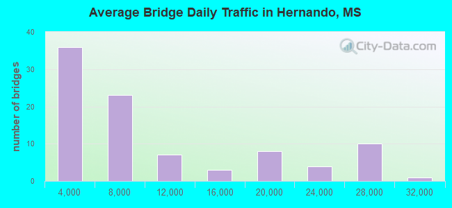
- 805,990Total average daily traffic
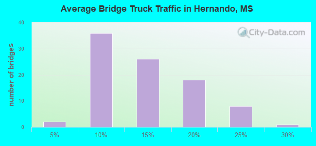
- 113,116Total average daily truck traffic
- National Bridge Inventory (NBI) Registered Bridges for Hernando
- No street view available for this location
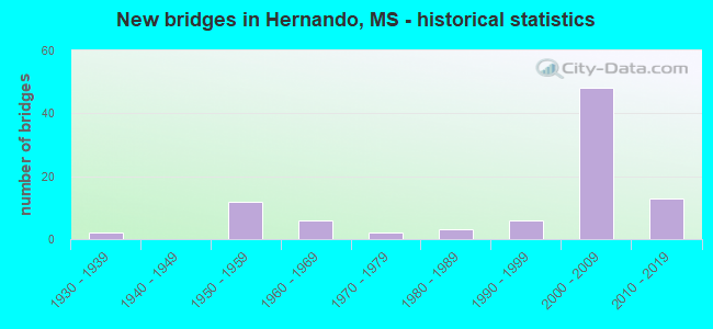
- New bridges - historical statistics
- 21930-1939
- 121950-1959
- 61960-1969
- 21970-1979
- 31980-1989
- 61990-1999
- 482000-2009
- 132010-2019
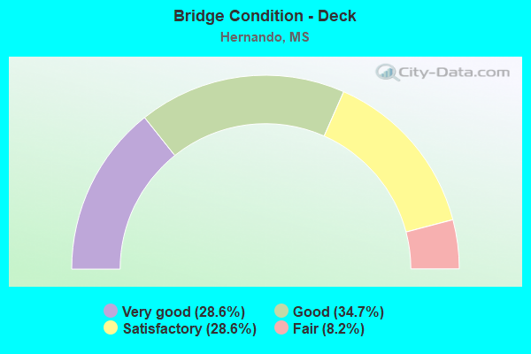
- Bridge Condition - Deck
- 28.6%Very good
- 34.7%Good
- 28.6%Satisfactory
- 8.2%Fair
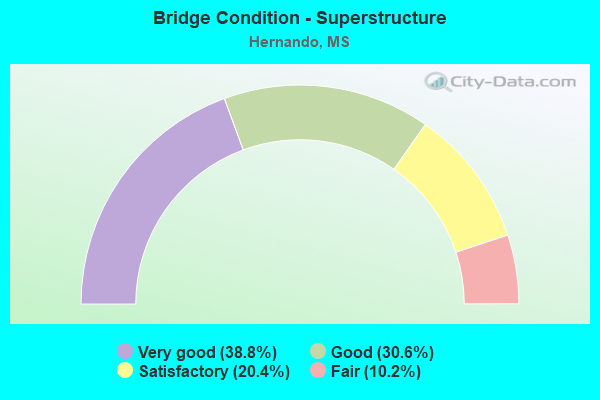
- Bridge Condition - Superstructure
- 38.8%Very good
- 30.6%Good
- 20.4%Satisfactory
- 10.2%Fair
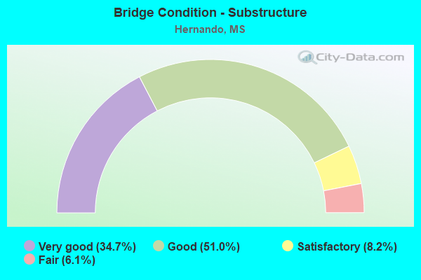
- Bridge Condition - Substructure
- 34.7%Very good
- 51.0%Good
- 8.2%Satisfactory
- 6.1%Fair
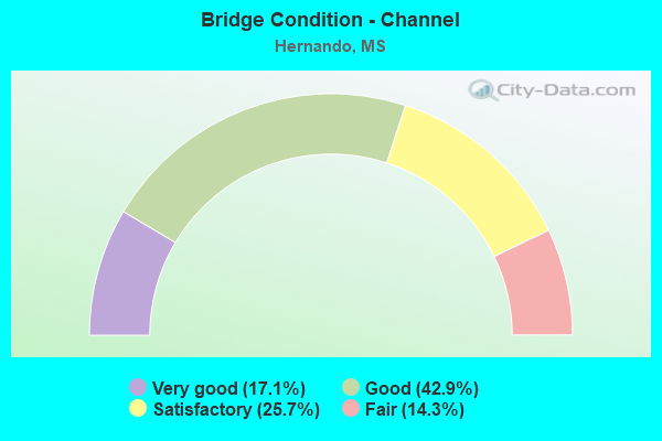
- Bridge Condition - Channel
- 17.1%Very good
- 42.9%Good
- 25.7%Satisfactory
- 14.3%Fair
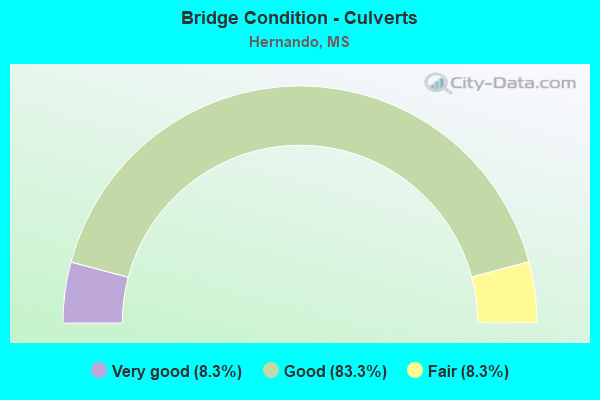
- Bridge Condition - Culverts
- 8.3%Very good
- 83.3%Good
- 8.3%Fair
Find on map >> Show street view
Structure Number: SA170000000007, Location: SEC 23 T 3S R 7W B (Lat: 34.813033, Lng: -89.910167), Route carried "on" structure: County highway 27, Year Built: 1965, Status: Posted for load, Structure Length: 3.66m (12.01ft), Average Daily Traffic: 500 (year 2018), Truck Traffic: 8%, Average Future Daily Traffic: 750 (year 2038), Design Load: H 15, Features Intersected: SHORT FORK CREEK, Facility Carried by Structure: JOHNSTON ROAD
Minimum Vertical Clearance: 30+ m (98+ ft), Kilometerpoint: 0.482, Lanes on structure: 2, Owner: County Highway Agency, Approaching Roadway Width: 6.7m (22.0ft), Material/Design: Prestressed concrete, Design/Construction: Stringer/Multi-beam, Number Of Spans In Main Unit: 3, Length of Maximum Span: 12.2m (40.0ft), Curb or Sidewalk Widths: Left: 0.7m (2.3ft), Right: 0.7m (2.3ft), Curb-To-Curb Width: 7.3m (24.0ft), Out-to-Out Width: 8.8m (28.9ft)
Condition: Deck: Satisfactory, Superstructure: Good, Substructure: Good, Channel: Good, Operating Rating: 58.5 metric tons, Method Used To Determine Operating Rating: Load Factor (LF), Inventory Rating: 21.3 metric tons, Method Used To Determine Inventory Rating: Load Factor (LF), Structural Evaluation: Equal to present minimum criteria, Deck Geometry: Meets minimum limits, Waterway Adequacy: Equal to present desirable criteria, Approach Roadway Alignment: Equal to present desirable criteria, Length Of Structure Improvement: 4.88m (16.01ft), Designated Inspection Frequency: Every 24 months, Inspection Date: May 2020, Bridge Improvement Cost: $291,000, Roadway Improvement Cost: $30,000, Total Project Cost: $359,000 ( Estimate for 2019), Deck Structure Type: Concrete Cast-file-Place, Wearing Surface/Protective System: Wearing Surface: Monolithic Concrete
Find on map >> Show street view
Structure Number: SA1700000000071, Location: SEC 25 T 3S R 7W B (Lat: 34.800817, Lng: -89.901050), Route carried "on" structure: County highway 1920, Year Built: 1992, Status: Posted for load, Structure Length: 3.63m (11.91ft), Average Daily Traffic: 2,600 (year 2020), Truck Traffic: 8%, Average Future Daily Traffic: 3,900 (year 2040), Design Load: H 15, Features Intersected: OLD SHORT FORK CREEK, Facility Carried by Structure: COCKRUM RD
Minimum Vertical Clearance: 30+ m (98+ ft), Kilometerpoint: 8.690, Lanes on structure: 2, Owner: County Highway Agency, Approaching Roadway Width: 7.3m (24.0ft), Material/Design: Concrete, Design/Construction: Slab, Number Of Spans In Main Unit: 3, Number Of Approach Spans: 2, Length of Maximum Span: 9.4m (30.8ft), Curb or Sidewalk Widths: Left: 0.7m (2.3ft), Right: 0.7m (2.3ft), Curb-To-Curb Width: 7.3m (24.0ft), Out-to-Out Width: 8.9m (29.2ft)
Condition: Deck: Fair, Superstructure: Fair, Substructure: Fair, Channel: Good, Operating Rating: 27.5 metric tons, Method Used To Determine Operating Rating: Load Factor (LF), Inventory Rating: 16.5 metric tons, Method Used To Determine Inventory Rating: Load Factor (LF), Structural Evaluation: Meets minimum limits, Deck Geometry: High priority of replacement, Waterway Adequacy: Better than present minimum criteria, Approach Roadway Alignment: Equal to present minimum criteria, Bridge Posting: Required (Relationship of Operating Rating to Maximum Legal Load: 20.0 - 29.9% below), Length Of Structure Improvement: 4.27m (14.01ft), Designated Inspection Frequency: Every 24 months, Inspection Date: April 2021, Bridge Improvement Cost: $255,000, Roadway Improvement Cost: $25,000, Total Project Cost: $314,000 ( Estimate for 2020), Deck Structure Type: Concrete Cast-file-Place, Wearing Surface/Protective System: Wearing Surface: Bituminous
Find on map >> Show street view
Structure Number: SA1700000000072, Location: SEC 25 T 3S R 7W B (Lat: 34.801133, Lng: -89.895867), Route carried "on" structure: County highway 1920, Year Built: 1968, Status: Posted for load, Structure Length: 6.10m (20.01ft), Average Daily Traffic: 2,100 (year 2015), Truck Traffic: 8%, Average Future Daily Traffic: 3,150 (year 2035), Design Load: H 15, Features Intersected: SHORT FORK CANAL, Facility Carried by Structure: COCKRUM RD
Minimum Vertical Clearance: 30+ m (98+ ft), Kilometerpoint: 9.173, Lanes on structure: 2, Owner: County Highway Agency, Approaching Roadway Width: 7.6m (24.9ft), Material/Design: Steel, Design/Construction: Stringer/Multi-beam, Number Of Spans In Main Unit: 5, Length of Maximum Span: 12.2m (40.0ft), Curb or Sidewalk Widths: Left: 0.7m (2.3ft), Right: 0.7m (2.3ft), Curb-To-Curb Width: 7.3m (24.0ft), Out-to-Out Width: 8.7m (28.5ft)
Condition: Deck: Satisfactory, Superstructure: Satisfactory, Substructure: Good, Channel: Fair, Operating Rating: 32.4 metric tons, Method Used To Determine Operating Rating: Load Factor (LF) rating reported by rating factor (RF) method using MS18 loading, Inventory Rating: 19.4 metric tons, Method Used To Determine Inventory Rating: Load Factor (LF) rating reported by rating factor (RF) method using MS18 loading, Structural Evaluation: Somewhat better than minimum adequacy, Deck Geometry: High priority of replacement, Waterway Adequacy: Equal to present minimum criteria, Approach Roadway Alignment: Equal to present desirable criteria, Bridge Posting: Required (Relationship of Operating Rating to Maximum Legal Load: 10.0 - 19.9% below), Length Of Structure Improvement: 7.32m (24.02ft), Designated Inspection Frequency: Every 12 months, Inspection Date: December 2021, Bridge Improvement Cost: $437,000, Roadway Improvement Cost: $45,000, Total Project Cost: $540,000 ( Estimate for 2016), Deck Structure Type: Concrete Cast-file-Place, Wearing Surface/Protective System: Wearing Surface: Bituminous
Find on map >> Show street view
Structure Number: SA1700000000073, Location: SEC 25 T 3S R 7W B (Lat: 34.801567, Lng: -89.889817), Route carried "on" structure: County highway 1920, Year Built: 1984, Status: Posted for load, Structure Length: 9.48m (31.10ft), Average Daily Traffic: 3,300 (year 2018), Truck Traffic: 8%, Average Future Daily Traffic: 4,950 (year 2038), Design Load: HS 20, Features Intersected: CAMP CREEK, Facility Carried by Structure: HOLLY SPRINGS RD
Minimum Vertical Clearance: 30+ m (98+ ft), Kilometerpoint: 9.656, Lanes on structure: 2, Owner: County Highway Agency, Approaching Roadway Width: 7.0m (23.0ft), Material/Design: Prestressed concrete, Design/Construction: Stringer/Multi-beam, Number Of Spans In Main Unit: 7, Length of Maximum Span: 24.4m (80.1ft), Curb or Sidewalk Widths: Left: 0.5m (1.6ft), Right: 0.5m (1.6ft), Curb-To-Curb Width: 8.5m (27.9ft), Out-to-Out Width: 9.5m (31.2ft)
Condition: Deck: Satisfactory, Superstructure: Good, Substructure: Good, Channel: Good, Operating Rating: 62.1 metric tons, Method Used To Determine Operating Rating: Load Factor (LF), Inventory Rating: 37.6 metric tons, Method Used To Determine Inventory Rating: Load Factor (LF), Structural Evaluation: Better than present minimum criteria, Deck Geometry: Meets minimum limits, Waterway Adequacy: Equal to present minimum criteria, Approach Roadway Alignment: Equal to present desirable criteria, Length Of Structure Improvement: 12.20m (40.03ft), Designated Inspection Frequency: Every 24 months, Inspection Date: May 2020, Bridge Improvement Cost: $728,000, Roadway Improvement Cost: $72,000, Total Project Cost: $896,000 ( Estimate for 2019), Deck Structure Type: Concrete Cast-file-Place, Wearing Surface/Protective System: Wearing Surface: Monolithic Concrete
Find on map >> Show street view
Structure Number: SA1700000000074, Location: SEC 33 T 3S R 7W B (Lat: 34.782417, Lng: -89.936383), Route carried "on" structure: County highway 20, Year Built: 1985, Status: Open, Structure Length: 2.83m (9.28ft), Average Daily Traffic: 1,600 (year 2020), Truck Traffic: 15%, Average Future Daily Traffic: 2,400 (year 2040), Design Load: HS 20, Features Intersected: GREYS CREEK, Facility Carried by Structure: GETWELL ROAD
Minimum Vertical Clearance: 30+ m (98+ ft), Kilometerpoint: 8.851, Lanes on structure: 2, Owner: County Highway Agency, Approaching Roadway Width: 7.0m (23.0ft), Material/Design: Concrete, Design/Construction: Channel Beam, Number Of Spans In Main Unit: 3, Length of Maximum Span: 9.4m (30.8ft), Curb or Sidewalk Widths: Left: 0.5m (1.6ft), Right: 0.5m (1.6ft), Curb-To-Curb Width: 8.5m (27.9ft), Out-to-Out Width: 9.5m (31.2ft)
Condition: Deck: Satisfactory, Superstructure: Fair, Substructure: Good, Channel: Good, Operating Rating: 35.3 metric tons, Method Used To Determine Operating Rating: Load Factor (LF), Inventory Rating: 21.2 metric tons, Method Used To Determine Inventory Rating: Load Factor (LF), Structural Evaluation: Somewhat better than minimum adequacy, Deck Geometry: Somewhat better than minimum adequacy, Waterway Adequacy: Equal to present desirable criteria, Approach Roadway Alignment: Equal to present desirable criteria, Length Of Structure Improvement: 3.66m (12.01ft), Designated Inspection Frequency: Every 12 months, Inspection Date: April 2021, Bridge Improvement Cost: $218,000, Roadway Improvement Cost: $22,000, Total Project Cost: $269,000 ( Estimate for 2020), Deck Structure Type: Concrete Precast Panels, Wearing Surface/Protective System: Wearing Surface: Monolithic Concrete
Find on map >> Show street view
Structure Number: SA1700000000075, Location: SEC 3 T 3S R 8W (Lat: 34.860400, Lng: -90.041483), Route carried "on" structure: County highway 517, Year Built: 1996, Status: Open, Structure Length: 0.78m (2.56ft), Average Daily Traffic: 300 (year 2018), Truck Traffic: 8%, Average Future Daily Traffic: 450 (year 2038), Design Load: HS 20, Features Intersected: UNNAMED CREEK, Facility Carried by Structure: ODOM ROAD
Minimum Vertical Clearance: 30+ m (98+ ft), Kilometerpoint: 3.218, Lanes on structure: 2, Owner: County Highway Agency, Approaching Roadway Width: 9.1m (29.9ft), Skew: 3 degrees, Material/Design: Concrete, Design/Construction: Culvert, Number Of Spans In Main Unit: 2, Length of Maximum Span: 3.0m (9.8ft)
Condition: Channel: Good, Culverts: Good, Operating Rating: 82.7 metric tons, Method Used To Determine Operating Rating: Load Factor (LF), Inventory Rating: 49.7 metric tons, Method Used To Determine Inventory Rating: Load Factor (LF), Structural Evaluation: Better than present minimum criteria, Waterway Adequacy: Equal to present desirable criteria, Approach Roadway Alignment: Equal to present desirable criteria, Designated Inspection Frequency: Every 24 months, Inspection Date: May 2020
Find on map >> Show street view
Structure Number: SA1700000000078, Location: SEC 8 T 3S R 8W (Lat: 34.835383, Lng: -90.060350), Route carried "on" structure: County highway 763, Year Built: 1998, Status: Open, Structure Length: 1.05m (3.44ft), Average Daily Traffic: 50 (year 2018), Average Future Daily Traffic: 75 (year 2038), Design Load: HS 20, Features Intersected: UNNAMED DITCH, Facility Carried by Structure: HORN LAKE RD
Minimum Vertical Clearance: 30+ m (98+ ft), Kilometerpoint: 0.482, Lanes on structure: 2, Owner: County Highway Agency, Approaching Roadway Width: 9.1m (29.9ft), Material/Design: Concrete, Design/Construction: Culvert, Number Of Spans In Main Unit: 2, Length of Maximum Span: 4.9m (16.1ft)
Condition: Channel: Satisfactory, Culverts: Good, Operating Rating: 53.9 metric tons, Method Used To Determine Operating Rating: Load Factor (LF), Inventory Rating: 32.4 metric tons, Method Used To Determine Inventory Rating: Load Factor (LF), Structural Evaluation: Better than present minimum criteria, Waterway Adequacy: Equal to present minimum criteria, Approach Roadway Alignment: Equal to present minimum criteria, Designated Inspection Frequency: Every 24 months, Inspection Date: May 2020
Find on map >> Show street view
Structure Number: SA1700000000079, Location: SEC 26 T 3S R 8W B (Lat: 34.788611, Lng: -90.024722), Route carried "on" structure: County highway 1968, Year Built: 1962, Status: Open, Structure Length: 1.09m (3.58ft), Average Daily Traffic: 630 (year 2018), Truck Traffic: 8%, Average Future Daily Traffic: 945 (year 2038), Design Load: HS 15, Features Intersected: MUSSACUNA CREEK, Facility Carried by Structure: ROBERTSON GIN ROAD
Minimum Vertical Clearance: 30+ m (98+ ft), Kilometerpoint: 5.149, Lanes on structure: 2, Owner: County Highway Agency, Approaching Roadway Width: 7.3m (24.0ft), Material/Design: Concrete, Design/Construction: Culvert, Number Of Spans In Main Unit: 2, Length of Maximum Span: 3.0m (9.8ft)
Condition: Channel: Good, Culverts: Good, Operating Rating: 47.7 metric tons, Method Used To Determine Operating Rating: Load Factor (LF), Inventory Rating: 28.5 metric tons, Method Used To Determine Inventory Rating: Load Factor (LF), Structural Evaluation: Better than present minimum criteria, Waterway Adequacy: Equal to present desirable criteria, Approach Roadway Alignment: Equal to present desirable criteria, Designated Inspection Frequency: Every 24 months, Inspection Date: May 2020
Find on map >> Show street view
Structure Number: SA170000000008, Location: SEC 35 T 3S R 8W B (Lat: 34.775967, Lng: -90.024733), Route carried "on" structure: County highway 1968, Year Built: 1973, Status: Open, Structure Length: 3.66m (12.01ft), Average Daily Traffic: 630 (year 2018), Truck Traffic: 8%, Average Future Daily Traffic: 945 (year 2038), Design Load: HS 15, Features Intersected: CANE CREEK, Facility Carried by Structure: ROBERTSON GIN ROAD
Minimum Vertical Clearance: 30+ m (98+ ft), Kilometerpoint: 3.540, Lanes on structure: 2, Owner: County Highway Agency, Approaching Roadway Width: 7.3m (24.0ft), Material/Design: Prestressed concrete, Design/Construction: Stringer/Multi-beam, Number Of Spans In Main Unit: 3, Length of Maximum Span: 12.2m (40.0ft), Curb or Sidewalk Widths: Left: 0.4m (1.3ft), Right: 0.4m (1.3ft), Curb-To-Curb Width: 7.9m (25.9ft), Out-to-Out Width: 8.8m (28.9ft)
Condition: Deck: Good, Superstructure: Good, Substructure: Satisfactory, Channel: Satisfactory, Operating Rating: 60.8 metric tons, Method Used To Determine Operating Rating: Load Factor (LF), Inventory Rating: 27.5 metric tons, Method Used To Determine Inventory Rating: Load Factor (LF), Structural Evaluation: Equal to present minimum criteria, Deck Geometry: Somewhat better than minimum adequacy, Waterway Adequacy: Equal to present desirable criteria, Approach Roadway Alignment: Equal to present desirable criteria, Designated Inspection Frequency: Every 24 months, Inspection Date: May 2020, Deck Structure Type: Concrete Cast-file-Place, Wearing Surface/Protective System: Wearing Surface: Monolithic Concrete
Find on map >> Show street view
Structure Number: SA1700000000103, Location: SEC 10 T 3S R 8W (Lat: 34.835450, Lng: -90.042650), Route carried "on" structure: County highway 124, Year Built: 2007, Status: Open, Structure Length: 0.92m (3.02ft), Average Daily Traffic: 1,000 (year 2018), Truck Traffic: 8%, Average Future Daily Traffic: 1,500 (year 2038), Design Load: HS 20, Features Intersected: UNNAMED DITCH, Facility Carried by Structure: TULANE ROAD
Minimum Vertical Clearance: 30+ m (98+ ft), Kilometerpoint: 0.515, Lanes on structure: 2, Owner: County Highway Agency, Approaching Roadway Width: 9.1m (29.9ft), Material/Design: Concrete, Design/Construction: Culvert, Number Of Spans In Main Unit: 2, Length of Maximum Span: 4.3m (14.1ft)
Condition: Channel: Satisfactory, Culverts: Good, Operating Rating: 50.7 metric tons, Method Used To Determine Operating Rating: Load Factor (LF), Inventory Rating: 30.4 metric tons, Method Used To Determine Inventory Rating: Load Factor (LF), Structural Evaluation: Better than present minimum criteria, Waterway Adequacy: Equal to present desirable criteria, Approach Roadway Alignment: Equal to present desirable criteria, Designated Inspection Frequency: Every 24 months, Inspection Date: May 2020
Find on map >> Show street view
Structure Number: SA1700000000104, Location: SEC 34 T 2S R 8W (Lat: 34.861333, Lng: -90.042583), Route carried "on" structure: County highway 124, Year Built: 2006, Status: Open, Structure Length: 0.78m (2.56ft), Average Daily Traffic: 5,000 (year 2018), Truck Traffic: 8%, Average Future Daily Traffic: 7,500 (year 2038), Design Load: HS 20, Features Intersected: UNNAMED DITCH, Facility Carried by Structure: TULANE ROAD
Minimum Vertical Clearance: 30+ m (98+ ft), Kilometerpoint: 3.412, Lanes on structure: 2, Owner: County Highway Agency, Approaching Roadway Width: 9.1m (29.9ft), Skew: 3 degrees, Material/Design: Concrete, Design/Construction: Culvert, Number Of Spans In Main Unit: 2, Length of Maximum Span: 3.0m (9.8ft)
Condition: Channel: Satisfactory, Culverts: Good, Operating Rating: 71.9 metric tons, Method Used To Determine Operating Rating: Load Factor (LF), Inventory Rating: 43.2 metric tons, Method Used To Determine Inventory Rating: Load Factor (LF), Structural Evaluation: Better than present minimum criteria, Waterway Adequacy: Equal to present desirable criteria, Approach Roadway Alignment: Equal to present desirable criteria, Designated Inspection Frequency: Every 24 months, Inspection Date: May 2020
Find on map >> Show street view
Structure Number: SA1700000000105, Location: SEC 33 T 2S R 8W (Lat: 34.872417, Lng: -90.045083), Route carried "on" structure: County highway 124, Year Built: 2006, Status: Open, Structure Length: 7.32m (24.02ft), Average Daily Traffic: 1,000 (year 2018), Truck Traffic: 8%, Average Future Daily Traffic: 1,500 (year 2038), Design Load: HS 20, Features Intersected: HURRICANE CREEK, Facility Carried by Structure: TULANE ROAD
Minimum Vertical Clearance: 30+ m (98+ ft), Kilometerpoint: 4.715, Lanes on structure: 2, Owner: County Highway Agency, Approaching Roadway Width: 7.6m (24.9ft), Skew: 3 degrees, Material/Design: Prestressed concrete, Design/Construction: Stringer/Multi-beam, Number Of Spans In Main Unit: 5, Length of Maximum Span: 24.4m (80.1ft), Curb or Sidewalk Widths: Left: 0.5m (1.6ft), Right: 0.5m (1.6ft), Curb-To-Curb Width: 9.1m (29.9ft), Out-to-Out Width: 10.1m (33.1ft)
Condition: Deck: Good, Superstructure: Very good, Substructure: Very good, Channel: Very good, Operating Rating: 61.4 metric tons, Method Used To Determine Operating Rating: Load Factor (LF), Inventory Rating: 28.5 metric tons, Method Used To Determine Inventory Rating: Load Factor (LF), Structural Evaluation: Better than present minimum criteria, Deck Geometry: Equal to present minimum criteria, Waterway Adequacy: Equal to present desirable criteria, Approach Roadway Alignment: Equal to present desirable criteria, Designated Inspection Frequency: Every 24 months, Inspection Date: May 2020, Deck Structure Type: Concrete Cast-file-Place, Wearing Surface/Protective System: Wearing Surface: Monolithic Concrete
Find on map >> Show street view
Structure Number: SA1700000000107, Location: SEC 32 T 2S R 7W (Lat: 34.871467, Lng: -89.971550), Route carried "on" structure: City street 126, Year Built: 2006, Status: Open, Structure Length: 4.88m (16.01ft), Average Daily Traffic: 2,000 (year 2018), Truck Traffic: 8%, Average Future Daily Traffic: 3,000 (year 2038), Design Load: HS 20, Features Intersected: HURRICANE CREEK, Facility Carried by Structure: MCINGVALE ROAD
Minimum Vertical Clearance: 30+ m (98+ ft), Kilometerpoint: 1.236, Lanes on structure: 4, Owner: City or Municipal Highway Agency, Approaching Roadway Width: 18.6m (61.0ft), Material/Design: Prestressed concrete, Design/Construction: Stringer/Multi-beam, Number Of Spans In Main Unit: 3, Length of Maximum Span: 24.4m (80.1ft), Curb or Sidewalk Widths: Left: 0.4m (1.3ft), Right: 0.4m (1.3ft), Curb-To-Curb Width: 21.0m (68.9ft), Out-to-Out Width: 21.8m (71.5ft)
Condition: Deck: Good, Superstructure: Very good, Substructure: Very good, Channel: Good, Operating Rating: 57.8 metric tons, Method Used To Determine Operating Rating: Load Factor (LF), Inventory Rating: 25.2 metric tons, Method Used To Determine Inventory Rating: Load Factor (LF), Structural Evaluation: Equal to present minimum criteria, Deck Geometry: Superior to present desirable criteria, Waterway Adequacy: Equal to present desirable criteria, Approach Roadway Alignment: Equal to present desirable criteria, Designated Inspection Frequency: Every 24 months, Inspection Date: May 2020, Deck Structure Type: Concrete Cast-file-Place, Wearing Surface/Protective System: Wearing Surface: Monolithic Concrete
Find on map >> Show street view
Structure Number: SA1700000000108, Location: SEC 13 T 3S R 9W (Lat: 34.829472, Lng: -90.102242), Route carried "on" structure: County highway 1304, Year Built: 1996, Status: Open, Structure Length: 10.98m (36.02ft), Average Daily Traffic: 6,100 (year 2020), Truck Traffic: 8%, Average Future Daily Traffic: 9,150 (year 2040), Design Load: HS 20, Features Intersected: PANTHER CREEK, Facility Carried by Structure: OLD HIGHWAY 304
Minimum Vertical Clearance: 30+ m (98+ ft), Kilometerpoint: 9.944, Lanes on structure: 2, Owner: County Highway Agency, Approaching Roadway Width: 8.2m (26.9ft), Material/Design: Prestressed concrete, Design/Construction: Stringer/Multi-beam, Number Of Spans In Main Unit: 9, Length of Maximum Span: 12.2m (40.0ft), Curb or Sidewalk Widths: Left: 0.5m (1.6ft), Right: 0.5m (1.6ft), Curb-To-Curb Width: 13.4m (44.0ft), Out-to-Out Width: 14.4m (47.2ft)
Condition: Deck: Good, Superstructure: Very good, Substructure: Satisfactory, Channel: Good, Operating Rating: 76.1 metric tons, Method Used To Determine Operating Rating: Load Factor (LF), Inventory Rating: 39.6 metric tons, Method Used To Determine Inventory Rating: Load Factor (LF), Structural Evaluation: Equal to present minimum criteria, Deck Geometry: Equal to present minimum criteria, Waterway Adequacy: Better than present minimum criteria, Approach Roadway Alignment: Equal to present desirable criteria, Designated Inspection Frequency: Every 24 months, Inspection Date: May 2020, Deck Structure Type: Concrete Cast-file-Place, Wearing Surface/Protective System: Wearing Surface: Monolithic Concrete
Find on map >> Show street view
Structure Number: SA1700000000109, Location: SEC 18 T 3S R 8W (Lat: 34.829658, Lng: -90.093975), Route carried "on" structure: County highway 1304, Year Built: 1996, Status: Open, Structure Length: 26.52m (87.01ft), Average Daily Traffic: 6,100 (year 2020), Truck Traffic: 8%, Average Future Daily Traffic: 9,150 (year 2040), Design Load: HS 20, Features Intersected: HURRICANE CREEK, Facility Carried by Structure: OLD HIGHWAY 304
Minimum Vertical Clearance: 30+ m (98+ ft), Kilometerpoint: 10.607, Lanes on structure: 2, Owner: County Highway Agency, Approaching Roadway Width: 13.4m (44.0ft), Skew: 4 degrees, Material/Design: Prestressed concrete, Design/Construction: Stringer/Multi-beam, Number Of Spans In Main Unit: 19, Length of Maximum Span: 30.5m (100.1ft), Curb or Sidewalk Widths: Left: 0.5m (1.6ft), Right: 0.5m (1.6ft), Curb-To-Curb Width: 13.4m (44.0ft), Out-to-Out Width: 14.4m (47.2ft)
Condition: Deck: Good, Superstructure: Very good, Substructure: Satisfactory, Channel: Good, Operating Rating: 43.2 metric tons, Method Used To Determine Operating Rating: Allowable Stress (AS), Inventory Rating: 32.4 metric tons, Method Used To Determine Inventory Rating: Allowable Stress (AS), Structural Evaluation: Equal to present minimum criteria, Deck Geometry: Equal to present minimum criteria, Waterway Adequacy: Equal to present desirable criteria, Approach Roadway Alignment: Equal to present desirable criteria, Designated Inspection Frequency: Every 24 months, Inspection Date: May 2020, Deck Structure Type: Concrete Cast-file-Place, Wearing Surface/Protective System: Wearing Surface: Monolithic Concrete
Find on map >> Show street view
Structure Number: SA170000000011, Location: SEC 1 T 3S R 8W (Lat: 34.853083, Lng: -89.997861), Route carried "on" structure: Spur City street 128, Year Built: 2006, Status: Open, Structure Length: 0.80m (2.62ft), Average Daily Traffic: 1,000 (year 2018), Truck Traffic: 8%, Average Future Daily Traffic: 1,500 (year 2038), Design Load: HS 20, Features Intersected: UNNAMED DITCH, Facility Carried by Structure: OLD HIGHWAY 51
Minimum Vertical Clearance: 30+ m (98+ ft), Kilometerpoint: 0.321, Lanes on structure: 2, Owner: City or Municipal Highway Agency, Approaching Roadway Width: 6.7m (22.0ft), Material/Design: Concrete, Design/Construction: Culvert, Number Of Spans In Main Unit: 2, Length of Maximum Span: 3.7m (12.1ft)
Condition: Channel: Satisfactory, Culverts: Good, Inventory Rating: 91.4 metric tons, Method Used To Determine Inventory Rating: Load Factor (LF), Structural Evaluation: Better than present minimum criteria, Waterway Adequacy: Equal to present minimum criteria, Approach Roadway Alignment: Equal to present desirable criteria, Designated Inspection Frequency: Every 24 months, Inspection Date: May 2020
Find on map >> Show street view
Structure Number: SA1700000000113, Location: SEC 27 T 2S R 8W (Lat: 34.880817, Lng: -90.032167), Route carried "on" structure: County highway 741, Year Built: 2011, Status: Open, Structure Length: 4.27m (14.01ft), Average Daily Traffic: 1,000 (year 2018), Truck Traffic: 8%, Average Future Daily Traffic: 1,500 (year 2038), Design Load: HS 20, Features Intersected: UNNAMED DITCH, Facility Carried by Structure: DEAN ROAD
Minimum Vertical Clearance: 30+ m (98+ ft), Kilometerpoint: 2.574, Lanes on structure: 2, Owner: County Highway Agency, Approaching Roadway Width: 7.3m (24.0ft), Material/Design: Prestressed concrete, Design/Construction: Stringer/Multi-beam, Number Of Spans In Main Unit: 3, Length of Maximum Span: 18.3m (60.0ft), Curb or Sidewalk Widths: Left: 0.5m (1.6ft), Right: 0.5m (1.6ft), Curb-To-Curb Width: 9.1m (29.9ft), Out-to-Out Width: 10.1m (33.1ft)
Condition: Deck: Good, Superstructure: Very good, Substructure: Very good, Channel: Very good, Operating Rating: 57.2 metric tons, Method Used To Determine Operating Rating: Load Factor (LF), Inventory Rating: 32.4 metric tons, Method Used To Determine Inventory Rating: Load Factor (LF), Structural Evaluation: Equal to present desirable criteria, Deck Geometry: Equal to present minimum criteria, Waterway Adequacy: Equal to present desirable criteria, Approach Roadway Alignment: Equal to present desirable criteria, Designated Inspection Frequency: Every 24 months, Inspection Date: May 2020, Deck Structure Type: Concrete Cast-file-Place, Wearing Surface/Protective System: Wearing Surface: Monolithic Concrete
Find on map >> Show street view
Structure Number: SA170000000A037, Location: SEC 22 T 2S R 8W B (Lat: 34.889867, Lng: -90.027433), Route carried "on" structure: County highway 974, Year Built: 2013, Status: Open, Structure Length: 1.06m (3.48ft), Average Daily Traffic: 1,500 (year 2018), Truck Traffic: 8%, Average Future Daily Traffic: 2,250 (year 2038), Design Load: HS 20, Features Intersected: DRAINAGE DITCH, Facility Carried by Structure: NESBIT ROAD
Minimum Vertical Clearance: 30+ m (98+ ft), Kilometerpoint: 8.368, Lanes on structure: 2, Owner: County Highway Agency, Approaching Roadway Width: 9.1m (29.9ft), Material/Design: Concrete, Design/Construction: Culvert, Number Of Spans In Main Unit: 2, Length of Maximum Span: 4.8m (15.7ft)
Condition: Channel: Good, Culverts: Good, Operating Rating: 85.6 metric tons, Method Used To Determine Operating Rating: Load Factor (LF), Inventory Rating: 51.3 metric tons, Method Used To Determine Inventory Rating: Load Factor (LF), Structural Evaluation: Better than present minimum criteria, Waterway Adequacy: Equal to present desirable criteria, Approach Roadway Alignment: Equal to present desirable criteria, Designated Inspection Frequency: Every 24 months, Inspection Date: May 2020
Find on map >> Show street view
Structure Number: SA170000000A076, Location: SEC 7 T 3S R 8W B (Lat: 34.835633, Lng: -90.078083), Route carried "on" structure: County highway 19, Year Built: 2018, Status: Open, Structure Length: 1.84m (6.04ft), Average Daily Traffic: 2,000 (year 2017), Truck Traffic: 10%, Average Future Daily Traffic: 3,000 (year 2037), Design Load: HS 20, Features Intersected: OLD HURRICANE CREEK, Facility Carried by Structure: FOGG ROAD
Minimum Vertical Clearance: 30+ m (98+ ft), Kilometerpoint: 7.081, Lanes on structure: 2, Owner: County Highway Agency, Approaching Roadway Width: 9.1m (29.9ft), Skew: 4 degrees, Material/Design: Concrete, Design/Construction: Culvert, Number Of Spans In Main Unit: 2, Length of Maximum Span: 6.1m (20.0ft)
Condition: Channel: Very good, Culverts: Very good, Inventory Rating: 81.9 metric tons, Method Used To Determine Inventory Rating: Load Factor (LF), Structural Evaluation: Equal to present desirable criteria, Waterway Adequacy: Equal to present desirable criteria, Approach Roadway Alignment: Equal to present desirable criteria, Designated Inspection Frequency: Every 24 months, Inspection Date: July 2019
Find on map >> Show street view
Structure Number: SA170000000A077, Location: SEC 7 T 3S R 8W B (Lat: 34.840681, Lng: -90.078056), Route carried "on" structure: County highway 19, Year Built: 2018, Status: Open, Structure Length: 8.53m (27.99ft), Average Daily Traffic: 2,000 (year 2017), Truck Traffic: 10%, Average Future Daily Traffic: 3,000 (year 2037), Design Load: HL 93, Features Intersected: HURRICANE CREEK, Facility Carried by Structure: FOGG ROAD
Minimum Vertical Clearance: 30+ m (98+ ft), Kilometerpoint: 7.724, Lanes on structure: 2, Owner: County Highway Agency, Approaching Roadway Width: 9.1m (29.9ft), Skew: 3 degrees, Material/Design: Prestressed concrete, Design/Construction: Stringer/Multi-beam, Number Of Spans In Main Unit: 6, Length of Maximum Span: 24.4m (80.1ft), Curb or Sidewalk Widths: Left: 0.5m (1.6ft), Right: 0.5m (1.6ft), Curb-To-Curb Width: 9.1m (29.9ft), Out-to-Out Width: 10.1m (33.1ft)
Condition: Deck: Very good, Superstructure: Very good, Substructure: Very good, Channel: Very good, Operating Rating: 48.0 metric tons, Method Used To Determine Operating Rating: Load and Resistance Factor Rating (LRFR) rating reported by rating factor(RF) method using HL-93 loadings, Inventory Rating: 33.4 metric tons, Method Used To Determine Inventory Rating: Load and Resistance Factor Rating (LRFR) rating reported by rating factor(RF) method using HL-93 loadings, Structural Evaluation: Equal to present desirable criteria, Deck Geometry: Somewhat better than minimum adequacy, Waterway Adequacy: Equal to present desirable criteria, Approach Roadway Alignment: Equal to present desirable criteria, Designated Inspection Frequency: Every 24 months, Inspection Date: July 2019, Deck Structure Type: Concrete Cast-file-Place, Wearing Surface/Protective System: Wearing Surface: Monolithic Concrete
Find on map >> Show street view
Structure Number: 11000550172801A, Location: I 55 OVER SR 304 (Lat: 34.823889, Lng: -89.976319), Route carried "under" structure: State highway 304, Year Built: 1959, Structure Length: 0. m, Average Daily Traffic: 23,000 (year 2017), Truck Traffic: 12%, Features Intersected: SR 304, Facility Carried by Structure: I 55
Minimum Vertical Clearance: 4.57m (14.99ft), Kilometerpoint: 21.562, Lanes on structure: 2, Lanes under structure: 5, Material/Design: Concrete continuous, Design/Construction: Box Beam or Girders - Single/Spread, Length of Maximum Span: 20.4m (66.9ft)
Find on map >> Show street view
Structure Number: 11000550172801B, Location: I 55 OVER SR 304 (Lat: 34.823881, Lng: -89.976039), Route carried "under" structure: State highway 304, Year Built: 1959, Structure Length: 0. m, Average Daily Traffic: 23,000 (year 2017), Truck Traffic: 10%, Features Intersected: SR 304, Facility Carried by Structure: I 55
Minimum Vertical Clearance: 4.65m (15.26ft), Kilometerpoint: 21.588, Lanes on structure: 2, Lanes under structure: 5, Material/Design: Concrete continuous, Design/Construction: Box Beam or Girders - Single/Spread, Length of Maximum Span: 20.4m (66.9ft)
Find on map >> Show street view
Structure Number: 21000510172864, Location: IN HERNANDO (Lat: 34.832981, Lng: -89.994719), Route carried "under" structure: US 51, Year Built: 1953, Structure Length: 0. m, Average Daily Traffic: 9,600 (year 2017), Truck Traffic: 10%, Features Intersected: US 51, Facility Carried by Structure: CNIC RR
Minimum Vertical Clearance: 4.34m (14.24ft), Kilometerpoint: 12.468, Lanes under structure: 2, Material/Design: Steel, Design/Construction: Stringer/Multi-beam, Length of Maximum Span: 17.4m (57.1ft)
Find on map >> Show street view
Structure Number: 31003040170140B, Location: SR 304 OVER US 51 (Lat: 34.861531, Lng: -89.995361), Route carried "under" structure: US 51, Year Built: 2006, Structure Length: 0. m, Average Daily Traffic: 9,400 (year 2017), Truck Traffic: 10%, Features Intersected: US 51, Facility Carried by Structure: SR 304
Minimum Vertical Clearance: 5.23m (17.16ft), Kilometerpoint: 15.638, Lanes on structure: 2, Lanes under structure: 2, Material/Design: Prestressed concrete, Design/Construction: Stringer/Multi-beam, Length of Maximum Span: 27.1m (88.9ft)
Find on map >> Show street view
Structure Number: 31003040170140C, Location: SR 304 OVER US 51 (Lat: 34.861281, Lng: -89.995350), Route carried "under" structure: US 51, Year Built: 2006, Structure Length: 0. m, Average Daily Traffic: 9,400 (year 2017), Truck Traffic: 10%, Features Intersected: US 51, Facility Carried by Structure: SR 304
Minimum Vertical Clearance: 5.66m (18.57ft), Kilometerpoint: 15.611, Lanes on structure: 2, Lanes under structure: 2, Material/Design: Prestressed concrete, Design/Construction: Stringer/Multi-beam, Length of Maximum Span: 27.1m (88.9ft)
Find on map >> Show street view
Structure Number: 31003040170142A, Location: SR 304 OVER I 55 (Lat: 34.861519, Lng: -89.990711), Route carried "under" structure: ServiceOther road 55, Year Built: 2006, Structure Length: 0. m, Average Daily Traffic: 5,500 (year 2017), Truck Traffic: 5%, Features Intersected: I 55, Facility Carried by Structure: SR 304
Minimum Vertical Clearance: 6.30m (20.67ft), Kilometerpoint: 1.122, Lanes on structure: 3, Lanes under structure: 8, Material/Design: Prestressed concrete continuous, Design/Construction: Stringer/Multi-beam, Length of Maximum Span: 28.0m (91.9ft)
Find on map >> Show street view
Structure Number: 31003040170142A, Location: SR 304 OVER I 55 (Lat: 34.861519, Lng: -89.990981), Route carried "under" structure: Interstate 55, Year Built: 2006, Structure Length: 0. m, Average Daily Traffic: 24,500 (year 2017), Truck Traffic: 20%, Features Intersected: I 55, Facility Carried by Structure: SR 304
Minimum Vertical Clearance: 6.25m (20.51ft), Kilometerpoint: 21.158, Lanes on structure: 3, Lanes under structure: 8, Material/Design: Prestressed concrete continuous, Design/Construction: Stringer/Multi-beam, Length of Maximum Span: 28.0m (91.9ft)
Find on map >> Show street view
Structure Number: 31003040170142A, Location: SR 304 OVER I 55 (Lat: 34.861519, Lng: -89.991519), Route carried "under" structure: ServiceOther road 55, Year Built: 2006, Structure Length: 0. m, Average Daily Traffic: 500 (year 2017), Truck Traffic: 5%, Features Intersected: I 55, Facility Carried by Structure: SR 304
Minimum Vertical Clearance: 6.40m (21.00ft), Kilometerpoint: 0.977, Lanes on structure: 3, Lanes under structure: 8, Material/Design: Prestressed concrete continuous, Design/Construction: Stringer/Multi-beam, Length of Maximum Span: 28.0m (91.9ft)
Find on map >> Show street view
Structure Number: 31003040170142A, Location: SR 304 OVER I 55 (Lat: 34.861519, Lng: -89.991269), Route carried "under" structure: Interstate 55, Year Built: 2006, Structure Length: 0. m, Average Daily Traffic: 24,500 (year 2017), Truck Traffic: 20%, Features Intersected: I 55, Facility Carried by Structure: SR 304
Minimum Vertical Clearance: 5.97m (19.59ft), Kilometerpoint: 14.882, Lanes on structure: 3, Lanes under structure: 8, Material/Design: Prestressed concrete continuous, Design/Construction: Stringer/Multi-beam, Length of Maximum Span: 28.0m (91.9ft)
Find on map >> Show street view
Structure Number: 31003040170142B, Location: SR 304 OVER I 55 (Lat: 34.861239, Lng: -89.990661), Route carried "under" structure: ServiceOther road 55, Year Built: 2006, Structure Length: 0. m, Average Daily Traffic: 5,500 (year 2017), Truck Traffic: 5%, Features Intersected: I 55, Facility Carried by Structure: SR 304
Minimum Vertical Clearance: 5.59m (18.34ft), Kilometerpoint: 1.091, Lanes on structure: 3, Lanes under structure: 8, Material/Design: Prestressed concrete continuous, Design/Construction: Stringer/Multi-beam, Length of Maximum Span: 28.0m (91.9ft)
Find on map >> Show street view
Structure Number: 31003040170142B, Location: SR 304 OVER I 55 (Lat: 34.861250, Lng: -89.991489), Route carried "under" structure: ServiceOther road 55, Year Built: 2006, Structure Length: 0. m, Average Daily Traffic: 500 (year 2017), Truck Traffic: 5%, Features Intersected: I 55, Facility Carried by Structure: SR 304
Minimum Vertical Clearance: 5.74m (18.83ft), Kilometerpoint: 1.007, Lanes on structure: 3, Lanes under structure: 8, Material/Design: Prestressed concrete continuous, Design/Construction: Stringer/Multi-beam, Length of Maximum Span: 28.0m (91.9ft)
Find on map >> Show street view
Structure Number: 31003040170142B, Location: SR 304 OVER I 55 (Lat: 34.861250, Lng: -89.991231), Route carried "under" structure: Interstate 55, Year Built: 2006, Structure Length: 0. m, Average Daily Traffic: 24,500 (year 2017), Truck Traffic: 20%, Features Intersected: I 55, Facility Carried by Structure: SR 304
Minimum Vertical Clearance: 5.31m (17.42ft), Kilometerpoint: 14.911, Lanes on structure: 3, Lanes under structure: 8, Material/Design: Prestressed concrete continuous, Design/Construction: Stringer/Multi-beam, Length of Maximum Span: 28.0m (91.9ft)
Find on map >> Show street view
Structure Number: 31003040170142B, Location: SR 304 OVER I 55 (Lat: 34.861250, Lng: -89.990950), Route carried "under" structure: Interstate 55, Year Built: 2006, Structure Length: 0. m, Average Daily Traffic: 24,500 (year 2017), Truck Traffic: 20%, Features Intersected: I 55, Facility Carried by Structure: SR 304
Minimum Vertical Clearance: 5.56m (18.24ft), Kilometerpoint: 21.129, Lanes on structure: 3, Lanes under structure: 8, Material/Design: Prestressed concrete continuous, Design/Construction: Stringer/Multi-beam, Length of Maximum Span: 28.0m (91.9ft)
Find on map >> Show street view
Structure Number: 37003040170140A, Location: SR 304 WB RAMP OVER US 51 (Lat: 34.862089, Lng: -89.995369), Route carried "under" structure: US 51, Year Built: 2006, Structure Length: 0. m, Average Daily Traffic: 9,400 (year 2017), Truck Traffic: 10%, Features Intersected: US 51, Facility Carried by Structure: I55SB TO SR 304WB
Minimum Vertical Clearance: 5.23m (17.16ft), Kilometerpoint: 15.699, Lanes on structure: 1, Lanes under structure: 2, Material/Design: Prestressed concrete, Design/Construction: Stringer/Multi-beam, Length of Maximum Span: 28.0m (91.9ft)
Find on map >> Show street view
Structure Number: 37003040170140D, Location: SR 304 EB RAMP OVER US 51 (Lat: 34.861000, Lng: -89.995339), Route carried "under" structure: US 51, Year Built: 2006, Structure Length: 0. m, Average Daily Traffic: 9,400 (year 2017), Truck Traffic: 10%, Features Intersected: US 51, Facility Carried by Structure: SR 304EB TO I55SB
Minimum Vertical Clearance: 5.30m (17.39ft), Kilometerpoint: 15.578, Lanes on structure: 1, Lanes under structure: 2, Material/Design: Prestressed concrete, Design/Construction: Stringer/Multi-beam, Length of Maximum Span: 29.9m (98.1ft)
Find on map >> Show street view
Structure Number: 41000550172827, Location: 2.6 MI N SR 304 (Lat: 34.858661, Lng: -89.989400), Route carried "under" structure: Ramp Interstate 55, Year Built: 2004, Structure Length: 0. m, Average Daily Traffic: 400 (year 2017), Truck Traffic: 10%, Features Intersected: I 55, Facility Carried by Structure: GREEN T ROAD
Minimum Vertical Clearance: 7.15m (23.46ft), Kilometerpoint: 0.303, Lanes on structure: 2, Lanes under structure: 8, Material/Design: Prestressed concrete continuous, Design/Construction: Stringer/Multi-beam, Length of Maximum Span: 31.1m (102.0ft)
Find on map >> Show street view
Structure Number: 41000550172827, Location: 2.6 MI N SR 304 (Lat: 34.858519, Lng: -89.991111), Route carried "under" structure: Ramp Interstate 55, Year Built: 2004, Structure Length: 0. m, Average Daily Traffic: 930 (year 2017), Truck Traffic: 10%, Features Intersected: I 55, Facility Carried by Structure: GREEN T ROAD
Minimum Vertical Clearance: 5.69m (18.67ft), Kilometerpoint: 0.711, Lanes on structure: 2, Lanes under structure: 8, Material/Design: Prestressed concrete continuous, Design/Construction: Stringer/Multi-beam, Length of Maximum Span: 31.1m (102.0ft)
Find on map >> Show street view
Structure Number: 41000550172827, Location: 2.6 MI N SR 304 (Lat: 34.858511, Lng: -89.990789), Route carried "under" structure: ServiceOther road 55, Year Built: 2004, Structure Length: 0. m, Average Daily Traffic: 500 (year 2017), Truck Traffic: 10%, Features Intersected: I 55, Facility Carried by Structure: GREEN T ROAD
Minimum Vertical Clearance: 5.74m (18.83ft), Kilometerpoint: 1.320, Lanes on structure: 2, Lanes under structure: 8, Material/Design: Prestressed concrete continuous, Design/Construction: Stringer/Multi-beam, Length of Maximum Span: 31.1m (102.0ft)
Find on map >> Show street view
Structure Number: 41000550172827, Location: 2.6 MI N SR 304 (Lat: 34.858519, Lng: -89.990519), Route carried "under" structure: Interstate 55, Year Built: 2004, Structure Length: 0. m, Average Daily Traffic: 24,500 (year 2017), Truck Traffic: 10%, Features Intersected: I 55, Facility Carried by Structure: GREEN T ROAD
Minimum Vertical Clearance: 5.94m (19.49ft), Kilometerpoint: 0.301, Lanes on structure: 2, Lanes under structure: 8, Material/Design: Prestressed concrete continuous, Design/Construction: Stringer/Multi-beam, Length of Maximum Span: 31.1m (102.0ft)
Find on map >> Show street view
Structure Number: 41000550172827, Location: 2.6 MI N SR 304 (Lat: 34.858539, Lng: -89.990231), Route carried "under" structure: Interstate 55, Year Built: 2004, Structure Length: 0. m, Average Daily Traffic: 24,500 (year 2017), Truck Traffic: 10%, Features Intersected: I 55, Facility Carried by Structure: GREEN T ROAD
Minimum Vertical Clearance: 6.48m (21.26ft), Kilometerpoint: 14.909, Lanes on structure: 2, Lanes under structure: 8, Material/Design: Prestressed concrete continuous, Design/Construction: Stringer/Multi-beam, Length of Maximum Span: 31.1m (102.0ft)
Find on map >> Show street view
Structure Number: 41000550172827, Location: 2.6 MI N SR 304 (Lat: 34.858581, Lng: -89.989950), Route carried "under" structure: ServiceOther road 55, Year Built: 2004, Structure Length: 0. m, Average Daily Traffic: 870 (year 2017), Truck Traffic: 10%, Features Intersected: I 55, Facility Carried by Structure: GREEN T ROAD
Minimum Vertical Clearance: 7.39m (24.25ft), Kilometerpoint: 0.787, Lanes on structure: 2, Lanes under structure: 8, Material/Design: Prestressed concrete continuous, Design/Construction: Stringer/Multi-beam, Length of Maximum Span: 31.1m (102.0ft)
Find on map >> Show street view
Structure Number: 41002690170156, Location: 1.3 MI N I 55 (Lat: 34.864089, Lng: -89.968639), Route carried "under" structure: Interstate 269, Year Built: 2016, Structure Length: 0. m, Average Daily Traffic: 17,000 (year 2017), Truck Traffic: 17%, Features Intersected: I 269, Facility Carried by Structure: MCINGVALE ROAD
Minimum Vertical Clearance: 5.73m (18.80ft), Kilometerpoint: 0.000, Lanes on structure: 5, Lanes under structure: 6, Material/Design: Prestressed concrete continuous, Design/Construction: Stringer/Multi-beam, Length of Maximum Span: 33.5m (109.9ft)
Find on map >> Show street view
Structure Number: 41002690170156, Location: 1.3 MI N I 55 (Lat: 34.863761, Lng: -89.968500), Route carried "under" structure: Interstate 269, Year Built: 2016, Structure Length: 0. m, Average Daily Traffic: 17,000 (year 2017), Truck Traffic: 17%, Features Intersected: I 269, Facility Carried by Structure: MCINGVALE ROAD
Minimum Vertical Clearance: 5.28m (17.32ft), Kilometerpoint: 0.000, Lanes on structure: 5, Lanes under structure: 6, Material/Design: Prestressed concrete continuous, Design/Construction: Stringer/Multi-beam, Length of Maximum Span: 33.5m (109.9ft)
Find on map >> Show street view
Structure Number: 41002690170175, Location: 3.2 MI N I 55 (Lat: 34.869769, Lng: -89.936919), Route carried "under" structure: Interstate 269, Year Built: 2016, Structure Length: 0. m, Average Daily Traffic: 17,000 (year 2017), Truck Traffic: 17%, Features Intersected: I 269, Facility Carried by Structure: GETWELL ROAD
Minimum Vertical Clearance: 5.42m (17.78ft), Kilometerpoint: 0.000, Lanes on structure: 2, Lanes under structure: 4, Material/Design: Prestressed concrete continuous, Design/Construction: Stringer/Multi-beam, Length of Maximum Span: 32.6m (107.0ft)
Find on map >> Show street view
Structure Number: 41002690170175, Location: 3.2 MI N I 55 (Lat: 34.869419, Lng: -89.936919), Route carried "under" structure: Interstate 269, Year Built: 2016, Structure Length: 0. m, Average Daily Traffic: 17,000 (year 2017), Truck Traffic: 17%, Features Intersected: I 269, Facility Carried by Structure: GETWELL ROAD
Minimum Vertical Clearance: 5.46m (17.91ft), Kilometerpoint: 0.000, Lanes on structure: 2, Lanes under structure: 4, Material/Design: Prestressed concrete continuous, Design/Construction: Stringer/Multi-beam, Length of Maximum Span: 32.6m (107.0ft)
Find on map >> Show street view
Structure Number: 41003040170091, Location: 4.0 MI E SR 301 (Lat: 34.861131, Lng: -90.078100), Route carried "under" structure: State highway 304, Year Built: 2006, Structure Length: 0. m, Average Daily Traffic: 5,500 (year 2017), Truck Traffic: 8%, Features Intersected: SR 304, Facility Carried by Structure: FOGG ROAD
Minimum Vertical Clearance: 5.59m (18.34ft), Kilometerpoint: 12.862, Lanes on structure: 2, Lanes under structure: 4, Material/Design: Prestressed concrete continuous, Design/Construction: Stringer/Multi-beam, Length of Maximum Span: 29.9m (98.1ft)
Find on map >> Show street view
Structure Number: 41003040170091, Location: 4.0 MI E SR 301 (Lat: 34.861381, Lng: -90.078111), Route carried "under" structure: State highway 304, Year Built: 2006, Structure Length: 0. m, Average Daily Traffic: 5,500 (year 2017), Truck Traffic: 8%, Features Intersected: SR 304, Facility Carried by Structure: FOGG ROAD
Minimum Vertical Clearance: 5.74m (18.83ft), Kilometerpoint: 23.176, Lanes on structure: 2, Lanes under structure: 4, Material/Design: Prestressed concrete continuous, Design/Construction: Stringer/Multi-beam, Length of Maximum Span: 29.9m (98.1ft)
Find on map >> Show street view
Structure Number: 41003040170112, Location: 2.1 MI W US 51 (Lat: 34.866511, Lng: -90.043111), Route carried "under" structure: State highway 304, Year Built: 2006, Structure Length: 0. m, Average Daily Traffic: 5,500 (year 2017), Truck Traffic: 8%, Features Intersected: SR 304, Facility Carried by Structure: TULANE ROAD
Minimum Vertical Clearance: 5.59m (18.34ft), Kilometerpoint: 16.142, Lanes on structure: 2, Lanes under structure: 4, Material/Design: Prestressed concrete continuous, Design/Construction: Stringer/Multi-beam, Length of Maximum Span: 29.9m (98.1ft)
Find on map >> Show street view
Structure Number: 41003040170112, Location: 2.1 MI W US 51 (Lat: 34.866750, Lng: -90.043211), Route carried "under" structure: State highway 304, Year Built: 2006, Structure Length: 0. m, Average Daily Traffic: 5,500 (year 2017), Truck Traffic: 8%, Features Intersected: SR 304, Facility Carried by Structure: TULANE ROAD
Minimum Vertical Clearance: 5.64m (18.50ft), Kilometerpoint: 19.903, Lanes on structure: 2, Lanes under structure: 4, Material/Design: Prestressed concrete continuous, Design/Construction: Stringer/Multi-beam, Length of Maximum Span: 29.9m (98.1ft)
Find on map >> Show street view
Structure Number: 41003040170126, Location: 1.5 MI W US 51 (Lat: 34.867069, Lng: -90.018469), Route carried "under" structure: State highway 304, Year Built: 2006, Structure Length: 0. m, Average Daily Traffic: 5,500 (year 2017), Truck Traffic: 8%, Features Intersected: SR 304, Facility Carried by Structure: ODOM ROAD
Minimum Vertical Clearance: 5.23m (17.16ft), Kilometerpoint: 18.438, Lanes on structure: 2, Lanes under structure: 4, Material/Design: Prestressed concrete continuous, Design/Construction: Stringer/Multi-beam, Length of Maximum Span: 42.7m (140.1ft)
Find on map >> Show street view
Structure Number: 41003040170126, Location: 1.5 MI W US 51 (Lat: 34.867269, Lng: -90.018261), Route carried "under" structure: State highway 304, Year Built: 2006, Structure Length: 0. m, Average Daily Traffic: 5,500 (year 2017), Truck Traffic: 8%, Features Intersected: SR 304, Facility Carried by Structure: ODOM ROAD
Minimum Vertical Clearance: 5.31m (17.42ft), Kilometerpoint: 17.579, Lanes on structure: 2, Lanes under structure: 4, Material/Design: Prestressed concrete continuous, Design/Construction: Stringer/Multi-beam, Length of Maximum Span: 42.7m (140.1ft)