Bridge Statistics for Hickory, North Carolina (NC)
Condition, Traffic, Stress, Structural Evaluation, Project Costs
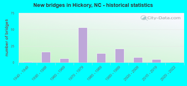
- New bridges - historical statistics
- 11940-1949
- 161950-1959
- 61960-1969
- 531970-1979
- 141980-1989
- 211990-1999
- 82000-2009
- 52010-2019
- 12020-2022

- Reconstructed bridges - Historical Statistics
- 11950-1959
- 01960-1969
- 11970-1979
- 01980-1989
- 21990-1999
- 12000-2009


- Bridge Condition - Deck
- 4.5%Excellent
- 4.5%Very good
- 27.3%Good
- 45.5%Satisfactory
- 15.9%Fair
- 2.3%Poor

- Bridge Condition - Superstructure
- 4.5%Excellent
- 2.3%Very good
- 52.3%Good
- 29.5%Satisfactory
- 6.8%Fair
- 4.5%Poor

- Bridge Condition - Substructure
- 4.5%Excellent
- 2.3%Very good
- 36.4%Good
- 31.8%Satisfactory
- 22.7%Fair
- 2.3%Poor

- Bridge Condition - Channel
- 2.1%Excellent
- 2.1%Very good
- 60.4%Good
- 27.1%Satisfactory
- 8.3%Fair

- Bridge Condition - Culverts
- 18.5%Good
- 51.9%Satisfactory
- 25.9%Fair
- 3.7%Poor
Find on map >> Show street view
Structure Number: 350161, Location: .2 MI.N.JCT.US70/US321BUS (Lat: 35.713319, Lng: -81.312903), Route carried "on" structure: State highway 1007, Year Built: 1975, Status: Open, Structure Length: 9.08m (29.79ft), Average Daily Traffic: 36,000 (year 2019), Truck Traffic: 6%, Average Future Daily Traffic: 72,000 (year 2040), Design Load: HS 20+Mod, Features Intersected: I40
Minimum Vertical Clearance: 30+ m (98+ ft), Kilometerpoint: 0.000, Lanes on structure: 6, Lanes under structure: 5, Owner: State Highway Agency, Approaching Roadway Width: 24.3m (79.7ft), Skew: 2 degrees, Material/Design: Steel continuous, Design/Construction: Stringer/Multi-beam, Number Of Spans In Main Unit: 2, Number Of Approach Spans: 2, Length of Maximum Span: 33.8m (110.9ft), Curb or Sidewalk Widths: Left: 1.5m (4.9ft), Right: 1.5m (4.9ft), Curb-To-Curb Width: 24.4m (80.1ft), Out-to-Out Width: 28.2m (92.5ft)
Condition: Deck: Good, Superstructure: Good, Substructure: Fair, Operating Rating: 63.5 metric tons, Method Used To Determine Operating Rating: Load Factor (LF), Inventory Rating: 38.1 metric tons, Method Used To Determine Inventory Rating: Load Factor (LF), Structural Evaluation: Somewhat better than minimum adequacy, Deck Geometry: Somewhat better than minimum adequacy, Underclear: Somewhat better than minimum adequacy, Approach Roadway Alignment: Equal to present desirable criteria, Designated Inspection Frequency: Every 24 months, Inspection Date: April 2021, Deck Structure Type: Concrete Cast-file-Place, Wearing Surface/Protective System: Wearing Surface: Epoxy Overlay, Membrane: Epoxy
Find on map >> Show street view
Structure Number: 350164, Location: 1.2 MI. E. JCT. SR1007 (Lat: 35.708097, Lng: -81.293519), Route carried "on" structure: Interstate 40, Year Built: 1975, Year Reconstructed: 1997, Status: Open, Structure Length: 0.79m (2.59ft), Average Daily Traffic: 68,500 (year 2019), Truck Traffic: 16%, Average Future Daily Traffic: 137,000 (year 2040), Design Load: HS 20+Mod, Features Intersected: CLARK CREEK
Minimum Vertical Clearance: 30+ m (98+ ft), Kilometerpoint: 38.557, Lanes on structure: 4, Base Highway Network: Yes (Inventory Route: 1, Subroute: 40), Owner: State Highway Agency, Approaching Roadway Width: 23.1m (75.8ft), Skew: 23 degrees, Material/Design: Concrete continuous, Design/Construction: Culvert, Number Of Spans In Main Unit: 2, Length of Maximum Span: 3.0m (9.8ft)
Condition: Channel: Good, Culverts: Satisfactory, Operating Rating: 89.8 metric tons, Method Used To Determine Operating Rating: Load Factor (LF), Inventory Rating: 89.8 metric tons, Method Used To Determine Inventory Rating: Load Factor (LF), Structural Evaluation: Equal to present minimum criteria, Waterway Adequacy: Better than present minimum criteria, Approach Roadway Alignment: Equal to present desirable criteria, Designated Inspection Frequency: Every 24 months, Underwater Inspection Frequency: Every 60 months, Inspection Date: January 2021, Underwater Inspection Date: January 2021
Find on map >> Show street view
Structure Number: 350165, Location: 0.5 MI. N. JCT. SR1475 (Lat: 35.707433, Lng: -81.278550), Route carried "on" structure: State highway 1468, Year Built: 1975, Status: Open, Structure Length: 7.65m (25.10ft), Average Daily Traffic: 4,000 (year 2019), Truck Traffic: 7%, Average Future Daily Traffic: 8,000 (year 2040), Design Load: HS 15, Features Intersected: I40
Minimum Vertical Clearance: 30+ m (98+ ft), Kilometerpoint: 0.000, Lanes on structure: 2, Lanes under structure: 4, Owner: State Highway Agency, Approaching Roadway Width: 10.9m (35.8ft), Material/Design: Steel continuous, Design/Construction: Stringer/Multi-beam, Number Of Spans In Main Unit: 2, Length of Maximum Span: 37.7m (123.7ft), Curb-To-Curb Width: 13.2m (43.3ft), Out-to-Out Width: 14.0m (45.9ft)
Condition: Deck: Satisfactory, Superstructure: Good, Substructure: Good, Operating Rating: 64.4 metric tons, Method Used To Determine Operating Rating: Load Factor (LF), Inventory Rating: 38.1 metric tons, Method Used To Determine Inventory Rating: Load Factor (LF), Structural Evaluation: Better than present minimum criteria, Deck Geometry: Equal to present minimum criteria, Underclear: Somewhat better than minimum adequacy, Approach Roadway Alignment: Equal to present desirable criteria, Designated Inspection Frequency: Every 24 months, Inspection Date: April 2021, Deck Structure Type: Concrete Cast-file-Place, Wearing Surface/Protective System: Wearing Surface: Monolithic Concrete
Find on map >> Show street view
Structure Number: 350166, Location: 0.5 MI. W. JCT. SR1475 (Lat: 35.707433, Lng: -81.278569), Route carried "on" structure: Interstate 40, Year Built: 1975, Status: Open, Structure Length: 1.06m (3.48ft), Average Daily Traffic: 63,500 (year 2019), Truck Traffic: 16%, Average Future Daily Traffic: 127,000 (year 2040), Design Load: HS 20+Mod, Features Intersected: CLARK CREEK
Minimum Vertical Clearance: 30+ m (98+ ft), Kilometerpoint: 38.801, Lanes on structure: 4, Base Highway Network: Yes (Inventory Route: 1, Subroute: 40), Owner: State Highway Agency, Approaching Roadway Width: 23.1m (75.8ft), Skew: 24 degrees, Material/Design: Concrete continuous, Design/Construction: Culvert, Number Of Spans In Main Unit: 2, Length of Maximum Span: 3.6m (11.8ft)
Condition: Channel: Good, Culverts: Good, Operating Rating: 41.7 metric tons, Method Used To Determine Operating Rating: Field evaluation and documented engineering judgment, Inventory Rating: 32.6 metric tons, Method Used To Determine Inventory Rating: Field evaluation and documented engineering judgment, Structural Evaluation: Better than present minimum criteria, Waterway Adequacy: Better than present minimum criteria, Approach Roadway Alignment: Equal to present desirable criteria, Designated Inspection Frequency: Every 24 months, Inspection Date: March 2021
Find on map >> Show street view
Structure Number: 350167, Location: 0.5 MI. W. JCT. SR1476 (Lat: 35.705819, Lng: -81.272178), Route carried "on" structure: Interstate 40, Year Built: 1975, Status: Open, Structure Length: 1.24m (4.07ft), Average Daily Traffic: 59,000 (year 2015), Truck Traffic: 16%, Average Future Daily Traffic: 118,000 (year 2040), Design Load: HS 20+Mod, Features Intersected: CLARK CREEK
Minimum Vertical Clearance: 30+ m (98+ ft), Kilometerpoint: 38.923, Lanes on structure: 4, Base Highway Network: Yes (Inventory Route: 1, Subroute: 40), Owner: State Highway Agency, Approaching Roadway Width: 23.1m (75.8ft), Skew: 23 degrees, Material/Design: Concrete continuous, Design/Construction: Culvert, Number Of Spans In Main Unit: 3, Length of Maximum Span: 3.3m (10.8ft)
Condition: Channel: Satisfactory, Culverts: Satisfactory, Operating Rating: 89.8 metric tons, Method Used To Determine Operating Rating: Load and Resistance Factor (LRFR), Inventory Rating: 89.8 metric tons, Method Used To Determine Inventory Rating: Load and Resistance Factor (LRFR), Structural Evaluation: Equal to present minimum criteria, Waterway Adequacy: Better than present minimum criteria, Approach Roadway Alignment: Equal to present desirable criteria, Designated Inspection Frequency: Every 24 months, Inspection Date: Febuary 2021
Find on map >> Show street view
Structure Number: 350168, Location: 0.12 MI. N. JCT. SR1477 (Lat: 35.703019, Lng: -81.262178), Route carried "on" structure: State highway 1476, Year Built: 1975, Status: Open, Structure Length: 8.83m (28.97ft), Average Daily Traffic: 17,000 (year 2019), Truck Traffic: 6%, Average Future Daily Traffic: 34,000 (year 2040), Design Load: HS 20+Mod, Features Intersected: I40
Minimum Vertical Clearance: 30+ m (98+ ft), Kilometerpoint: 0.000, Lanes on structure: 4, Lanes under structure: 4, Owner: State Highway Agency, Approaching Roadway Width: 16.7m (54.8ft), Skew: 2 degrees, Material/Design: Steel, Design/Construction: Stringer/Multi-beam, Number Of Spans In Main Unit: 4, Length of Maximum Span: 32.9m (107.9ft), Curb-To-Curb Width: 20.5m (67.3ft), Out-to-Out Width: 21.3m (69.9ft)
Condition: Deck: Satisfactory, Superstructure: Good, Substructure: Satisfactory, Operating Rating: 61.6 metric tons, Method Used To Determine Operating Rating: Load Factor (LF), Inventory Rating: 37.1 metric tons, Method Used To Determine Inventory Rating: Load Factor (LF), Structural Evaluation: Equal to present minimum criteria, Deck Geometry: Superior to present desirable criteria, Underclear: Somewhat better than minimum adequacy, Approach Roadway Alignment: Equal to present desirable criteria, Designated Inspection Frequency: Every 24 months, Inspection Date: April 2021, Deck Structure Type: Concrete Cast-file-Place, Wearing Surface/Protective System: Wearing Surface: Monolithic Concrete
Find on map >> Show street view
Structure Number: 350181, Location: 0.1 MI.E.OLD LENOIR ROAD (Lat: 35.747764, Lng: -81.362361), Route carried "on" structure: City street , Year Built: 1991, Status: Open, Structure Length: 1.03m (3.38ft), Average Daily Traffic: 9,100 (year 1994), Truck Traffic: 7%, Average Future Daily Traffic: 18,200 (year 2025), Design Load: HS 20, Features Intersected: FRYE CREEK, Facility Carried by Structure: 12TH AVENUE NW
Minimum Vertical Clearance: 30+ m (98+ ft), Kilometerpoint: 0.000, Lanes on structure: 2, Owner: City or Municipal Highway Agency, Approaching Roadway Width: 10.3m (33.8ft), Material/Design: Concrete continuous, Design/Construction: Culvert, Number Of Spans In Main Unit: 3, Length of Maximum Span: 3.3m (10.8ft)
Condition: Channel: Satisfactory, Culverts: Satisfactory, Operating Rating: 41.7 metric tons, Method Used To Determine Operating Rating: Field evaluation and documented engineering judgment, Inventory Rating: 32.6 metric tons, Method Used To Determine Inventory Rating: Field evaluation and documented engineering judgment, Structural Evaluation: Equal to present minimum criteria, Waterway Adequacy: Better than present minimum criteria, Approach Roadway Alignment: Equal to present desirable criteria, Designated Inspection Frequency: Every 24 months, Inspection Date: January 2022
Find on map >> Show street view
Structure Number: 350182, Location: 0.2MI.E.JCT.OLD LENOIR RD (Lat: 35.748239, Lng: -81.360122), Route carried "on" structure: City street , Year Built: 1991, Status: Open, Structure Length: 1.18m (3.87ft), Average Daily Traffic: 9,100 (year 1994), Truck Traffic: 7%, Average Future Daily Traffic: 18,200 (year 2025), Design Load: HS 20, Features Intersected: CRIPPLE CREEK, Facility Carried by Structure: 12TH AVENUE NW.
Minimum Vertical Clearance: 30+ m (98+ ft), Kilometerpoint: 0.000, Lanes on structure: 2, Owner: City or Municipal Highway Agency, Approaching Roadway Width: 10.3m (33.8ft), Skew: 1 degrees, Material/Design: Concrete continuous, Design/Construction: Culvert, Number Of Spans In Main Unit: 3, Length of Maximum Span: 3.6m (11.8ft)
Condition: Channel: Satisfactory, Culverts: Satisfactory, Operating Rating: 41.7 metric tons, Method Used To Determine Operating Rating: Field evaluation and documented engineering judgment, Inventory Rating: 32.6 metric tons, Method Used To Determine Inventory Rating: Field evaluation and documented engineering judgment, Structural Evaluation: Equal to present minimum criteria, Waterway Adequacy: Better than present minimum criteria, Approach Roadway Alignment: Equal to present desirable criteria, Designated Inspection Frequency: Every 24 months, Inspection Date: January 2022
Find on map >> Show street view
Structure Number: 350226, Location: 0.4 MI. E. JCT. SR1529 (Lat: 35.792228, Lng: -81.251208), Route carried "on" structure: State highway 1511, Year Built: 1975, Status: Open, Structure Length: 1.03m (3.38ft), Average Daily Traffic: 1,300 (year 2019), Truck Traffic: 7%, Average Future Daily Traffic: 2,600 (year 2040), Design Load: HS 20+Mod, Features Intersected: LONG SHOAL CREEK
Minimum Vertical Clearance: 30+ m (98+ ft), Kilometerpoint: 0.000, Lanes on structure: 2, Owner: State Highway Agency, Approaching Roadway Width: 8.5m (27.9ft), Material/Design: Steel, Design/Construction: Culvert, Number Of Spans In Main Unit: 3, Length of Maximum Span: 2.7m (8.9ft)
Condition: Channel: Good, Culverts: Satisfactory, Operating Rating: 89.8 metric tons, Method Used To Determine Operating Rating: Load and Resistance Factor (LRFR), Inventory Rating: 89.8 metric tons, Method Used To Determine Inventory Rating: Load and Resistance Factor (LRFR), Structural Evaluation: Equal to present minimum criteria, Waterway Adequacy: Better than present minimum criteria, Approach Roadway Alignment: Equal to present desirable criteria, Designated Inspection Frequency: Every 24 months, Inspection Date: Febuary 2021
Find on map >> Show street view
Structure Number: 350281, Location: 1.2 MI. S. JCT. US321 (Lat: 35.745242, Lng: -81.361206), Route carried "on" structure: State highway 1314, Year Built: 1940, Status: Open, Structure Length: 1.09m (3.58ft), Average Daily Traffic: 7,800 (year 2017), Truck Traffic: 6%, Average Future Daily Traffic: 15,600 (year 2040), Design Load: HS 15, Features Intersected: FRYE CREEK
Minimum Vertical Clearance: 30+ m (98+ ft), Kilometerpoint: 0.000, Lanes on structure: 4, Owner: State Highway Agency, Approaching Roadway Width: 13.4m (44.0ft), Skew: 4 degrees, Material/Design: Concrete continuous, Design/Construction: Culvert, Number Of Spans In Main Unit: 2, Length of Maximum Span: 3.6m (11.8ft)
Condition: Channel: Good, Culverts: Good, Operating Rating: 31.7 metric tons, Method Used To Determine Operating Rating: Field evaluation and documented engineering judgment, Inventory Rating: 24.4 metric tons, Method Used To Determine Inventory Rating: Field evaluation and documented engineering judgment, Structural Evaluation: Equal to present minimum criteria, Waterway Adequacy: Better than present minimum criteria, Approach Roadway Alignment: Equal to present desirable criteria, Designated Inspection Frequency: Every 24 months, Inspection Date: January 2021
Find on map >> Show street view
Structure Number: 350282, Location: 0.3 MI. N. JCT. NC127 (Lat: 35.787872, Lng: -81.306172), Route carried "on" structure: State highway 1400, Year Built: 1972, Status: Open, Structure Length: 0.88m (2.89ft), Average Daily Traffic: 9,700 (year 2017), Truck Traffic: 6%, Average Future Daily Traffic: 19,400 (year 2040), Design Load: HS 20+Mod, Features Intersected: FALLING CREEK
Minimum Vertical Clearance: 30+ m (98+ ft), Kilometerpoint: 0.000, Lanes on structure: 2, Owner: State Highway Agency, Approaching Roadway Width: 7.3m (24.0ft), Skew: 3 degrees, Material/Design: Concrete continuous, Design/Construction: Culvert, Number Of Spans In Main Unit: 2, Length of Maximum Span: 3.6m (11.8ft)
Condition: Channel: Good, Culverts: Good, Operating Rating: 41.7 metric tons, Method Used To Determine Operating Rating: Field evaluation and documented engineering judgment, Inventory Rating: 32.6 metric tons, Method Used To Determine Inventory Rating: Field evaluation and documented engineering judgment, Structural Evaluation: Better than present minimum criteria, Waterway Adequacy: Better than present minimum criteria, Approach Roadway Alignment: Equal to present desirable criteria, Designated Inspection Frequency: Every 24 months, Inspection Date: January 2021
Find on map >> Show street view
Structure Number: 350291, Location: 0.1 MI. S. JCT. SR1692 (Lat: 35.728611, Lng: -81.314006), Route carried "on" structure: City street , Year Built: 1960, Status: Open, Structure Length: 0.79m (2.59ft), Average Daily Traffic: 4,700 (year 1993), Truck Traffic: 7%, Average Future Daily Traffic: 9,400 (year 2025), Design Load: HS 20, Features Intersected: UT TO CLARK CREEK, Facility Carried by Structure: 15TH STREET SE
Minimum Vertical Clearance: 30+ m (98+ ft), Kilometerpoint: 0.000, Lanes on structure: 2, Owner: City or Municipal Highway Agency, Approaching Roadway Width: 7.6m (24.9ft), Skew: 4 degrees, Material/Design: Concrete continuous, Design/Construction: Culvert, Number Of Spans In Main Unit: 2, Length of Maximum Span: 2.7m (8.9ft)
Condition: Channel: Fair, Culverts: Satisfactory, Operating Rating: 41.7 metric tons, Method Used To Determine Operating Rating: Field evaluation and documented engineering judgment, Inventory Rating: 32.6 metric tons, Method Used To Determine Inventory Rating: Field evaluation and documented engineering judgment, Structural Evaluation: Equal to present minimum criteria, Waterway Adequacy: Better than present minimum criteria, Approach Roadway Alignment: Equal to present desirable criteria, Designated Inspection Frequency: Every 24 months, Inspection Date: January 2022
Find on map >> Show street view
Structure Number: 350292, Location: 0.4 MI. E. JCT. SR1468 (Lat: 35.709344, Lng: -81.273697), Route carried "on" structure: State highway 1478, Year Built: 1980, Status: Open, Structure Length: 0.64m (2.10ft), Average Daily Traffic: 3,300 (year 2019), Truck Traffic: 7%, Average Future Daily Traffic: 6,600 (year 2040), Design Load: HS 20+Mod, Features Intersected: MILLER CREEK
Minimum Vertical Clearance: 30+ m (98+ ft), Kilometerpoint: 0.000, Lanes on structure: 2, Owner: State Highway Agency, Approaching Roadway Width: 7.0m (23.0ft), Skew: 1 degrees, Material/Design: Steel, Design/Construction: Culvert, Number Of Spans In Main Unit: 2, Length of Maximum Span: 2.4m (7.9ft)
Condition: Channel: Good, Culverts: Satisfactory, Operating Rating: 89.8 metric tons, Method Used To Determine Operating Rating: Load and Resistance Factor (LRFR), Inventory Rating: 89.8 metric tons, Method Used To Determine Inventory Rating: Load and Resistance Factor (LRFR), Structural Evaluation: Equal to present minimum criteria, Waterway Adequacy: Better than present minimum criteria, Approach Roadway Alignment: Equal to present desirable criteria, Designated Inspection Frequency: Every 24 months, Inspection Date: January 2021
Find on map >> Show street view
Structure Number: 350293, Location: 0.1 MI. N. JCT. SR1695 (Lat: 35.761047, Lng: -81.293600), Route carried "on" structure: State highway 1402, Year Built: 1981, Status: Open, Structure Length: 0.70m (2.30ft), Average Daily Traffic: 15,500 (year 2019), Truck Traffic: 12%, Average Future Daily Traffic: 31,000 (year 2040), Design Load: HS 20, Features Intersected: SNOW CREEK
Minimum Vertical Clearance: 30+ m (98+ ft), Kilometerpoint: 0.000, Lanes on structure: 2, Owner: State Highway Agency, Approaching Roadway Width: 6.7m (22.0ft), Skew: 3 degrees, Material/Design: Steel, Design/Construction: Culvert, Number Of Spans In Main Unit: 2, Length of Maximum Span: 2.4m (7.9ft)
Condition: Channel: Good, Culverts: Poor, Operating Rating: 86.1 metric tons, Method Used To Determine Operating Rating: Load and Resistance Factor (LRFR), Inventory Rating: 66.2 metric tons, Method Used To Determine Inventory Rating: Load and Resistance Factor (LRFR), Structural Evaluation: Meets minimum limits, Waterway Adequacy: Better than present minimum criteria, Approach Roadway Alignment: Equal to present desirable criteria, Designated Inspection Frequency: Every 24 months, Inspection Date: Febuary 2021
Find on map >> Show street view
Structure Number: 350294, Location: 0.7 MI. N. JCT. SR1519 (Lat: 35.809475, Lng: -81.195644), Route carried "on" structure: State highway 1453, Year Built: 1980, Status: Open, Structure Length: 0.76m (2.49ft), Average Daily Traffic: 4,700 (year 2015), Truck Traffic: 6%, Average Future Daily Traffic: 9,400 (year 2040), Design Load: HS 20+Mod, Features Intersected: NAKED CREEK
Minimum Vertical Clearance: 30+ m (98+ ft), Kilometerpoint: 0.000, Lanes on structure: 2, Owner: State Highway Agency, Approaching Roadway Width: 7.3m (24.0ft), Skew: 4 degrees, Material/Design: Steel, Design/Construction: Culvert, Number Of Spans In Main Unit: 2, Length of Maximum Span: 2.4m (7.9ft)
Condition: Channel: Good, Culverts: Satisfactory, Operating Rating: 89.8 metric tons, Method Used To Determine Operating Rating: Load and Resistance Factor (LRFR), Inventory Rating: 89.8 metric tons, Method Used To Determine Inventory Rating: Load and Resistance Factor (LRFR), Structural Evaluation: Equal to present minimum criteria, Waterway Adequacy: Better than present minimum criteria, Approach Roadway Alignment: Equal to present desirable criteria, Designated Inspection Frequency: Every 24 months, Inspection Date: Febuary 2021
Find on map >> Show street view
Structure Number: 350295, Location: 0.1 MI. W. JCT. SR1457 (Lat: 35.729581, Lng: -81.315056), Route carried "on" structure: State highway 1692, Year Built: 1956, Status: Open, Structure Length: 0.64m (2.10ft), Average Daily Traffic: 13,000 (year 2013), Truck Traffic: 12%, Average Future Daily Traffic: 26,000 (year 2040), Design Load: HS 20+Mod, Features Intersected: CLARK CREEK
Minimum Vertical Clearance: 30+ m (98+ ft), Kilometerpoint: 0.000, Lanes on structure: 4, Base Highway Network: Yes (Inventory Route: 4, Subroute: 92), Owner: State Highway Agency, Approaching Roadway Width: 23.1m (75.8ft), Skew: 23 degrees, Material/Design: Concrete continuous, Design/Construction: Culvert, Number Of Spans In Main Unit: 2, Length of Maximum Span: 2.7m (8.9ft)
Condition: Channel: Good, Culverts: Satisfactory, Operating Rating: 41.7 metric tons, Method Used To Determine Operating Rating: Field evaluation and documented engineering judgment, Inventory Rating: 32.6 metric tons, Method Used To Determine Inventory Rating: Field evaluation and documented engineering judgment, Structural Evaluation: Equal to present minimum criteria, Waterway Adequacy: Better than present minimum criteria, Approach Roadway Alignment: Equal to present desirable criteria, Designated Inspection Frequency: Every 24 months, Inspection Date: January 2021
Find on map >> Show street view
Structure Number: 350296, Location: 0.3 MI. N. JCT. SR1306 (Lat: 35.740256, Lng: -81.365878), Route carried "on" structure: US 321, Year Built: 1957, Year Reconstructed: 1963, Status: Open, Structure Length: 0.64m (2.10ft), Average Daily Traffic: 34,000 (year 2013), Truck Traffic: 12%, Average Future Daily Traffic: 68,000 (year 2040), Design Load: HS 20+Mod, Features Intersected: FRYE CREEK
Minimum Vertical Clearance: 30+ m (98+ ft), Kilometerpoint: 0.000, Lanes on structure: 4, Base Highway Network: Yes (Inventory Route: 2, Subroute: 21), Owner: State Highway Agency, Approaching Roadway Width: 14.6m (47.9ft), Skew: 21 degrees, Material/Design: Concrete continuous, Design/Construction: Culvert, Number Of Spans In Main Unit: 2, Length of Maximum Span: 3.0m (9.8ft)
Condition: Channel: Good, Culverts: Satisfactory, Operating Rating: 41.7 metric tons, Method Used To Determine Operating Rating: Field evaluation and documented engineering judgment, Inventory Rating: 32.6 metric tons, Method Used To Determine Inventory Rating: Field evaluation and documented engineering judgment, Structural Evaluation: Equal to present minimum criteria, Waterway Adequacy: Better than present minimum criteria, Approach Roadway Alignment: Equal to present desirable criteria, Designated Inspection Frequency: Every 24 months, Inspection Date: January 2021
Find on map >> Show street view
Structure Number: 350305, Location: 0.3 MI. N. JCT. I40 (Lat: 35.713819, Lng: -81.355069), Route carried "on" structure: Bypass US 321, Year Built: 1976, Status: Open, Structure Length: 0.70m (2.30ft), Average Daily Traffic: 44,500 (year 2019), Truck Traffic: 12%, Average Future Daily Traffic: 89,000 (year 2040), Design Load: HS 20+Mod, Features Intersected: GEITNER BRANCH
Minimum Vertical Clearance: 30+ m (98+ ft), Kilometerpoint: 13.167, Lanes on structure: 8, Base Highway Network: Yes (Inventory Route: 3, Subroute: 21), Owner: State Highway Agency, Approaching Roadway Width: 42.6m (139.8ft), Skew: 25 degrees, Material/Design: Concrete continuous, Design/Construction: Culvert, Number Of Spans In Main Unit: 2, Length of Maximum Span: 2.1m (6.9ft)
Condition: Channel: Good, Culverts: Fair, Operating Rating: 41.7 metric tons, Method Used To Determine Operating Rating: Field evaluation and documented engineering judgment, Inventory Rating: 32.6 metric tons, Method Used To Determine Inventory Rating: Field evaluation and documented engineering judgment, Structural Evaluation: Somewhat better than minimum adequacy, Waterway Adequacy: Better than present minimum criteria, Approach Roadway Alignment: Equal to present desirable criteria, Designated Inspection Frequency: Every 24 months, Inspection Date: January 2021
Find on map >> Show street view
Structure Number: 350306, Location: 0.5 MI W JCT SR1401 (Lat: 35.761019, Lng: -81.318917), Route carried "on" structure: City street , Year Built: 2018, Status: Open, Structure Length: 0.91m (2.99ft), Average Daily Traffic: 3,450 (year 2017), Truck Traffic: 6%, Average Future Daily Traffic: 6,900 (year 2025), Features Intersected: FALLING CREEK, Facility Carried by Structure: 23RD AVENUE NE
Minimum Vertical Clearance: 30+ m (98+ ft), Kilometerpoint: 0.000, Lanes on structure: 2, Owner: City or Municipal Highway Agency, Approaching Roadway Width: 6.0m (19.7ft), Material/Design: Steel, Design/Construction: Culvert, Number Of Spans In Main Unit: 3, Length of Maximum Span: 3.0m (9.8ft)
Condition: Channel: Satisfactory, Culverts: Fair, Operating Rating: 89.8 metric tons, Method Used To Determine Operating Rating: Load and Resistance Factor (LRFR), Inventory Rating: 89.8 metric tons, Method Used To Determine Inventory Rating: Load and Resistance Factor (LRFR), Structural Evaluation: Somewhat better than minimum adequacy, Waterway Adequacy: Better than present minimum criteria, Approach Roadway Alignment: Equal to present desirable criteria, Designated Inspection Frequency: Every 24 months, Inspection Date: January 2022
Find on map >> Show street view
Structure Number: 350316, Location: 0.1 MI. E. JCT. SR1008 (Lat: 35.656806, Lng: -81.317647), Route carried "on" structure: State highway 1430, Year Built: 1995, Status: Open, Structure Length: 6.58m (21.59ft), Average Daily Traffic: 3,200 (year 2017), Truck Traffic: 7%, Average Future Daily Traffic: 6,400 (year 2040), Design Load: HS 20+Mod, Features Intersected: US321, Facility Carried by Structure: SR1143
Minimum Vertical Clearance: 30+ m (98+ ft), Kilometerpoint: 0.000, Lanes on structure: 2, Lanes under structure: 4, Owner: State Highway Agency, Approaching Roadway Width: 9.7m (31.8ft), Skew: 2 degrees, Material/Design: Steel continuous, Design/Construction: Stringer/Multi-beam, Number Of Spans In Main Unit: 2, Length of Maximum Span: 32.3m (106.0ft), Curb-To-Curb Width: 10.0m (32.8ft), Out-to-Out Width: 11.3m (37.1ft)
Condition: Deck: Satisfactory, Superstructure: Good, Substructure: Good, Operating Rating: 89.8 metric tons, Method Used To Determine Operating Rating: Load Factor (LF), Inventory Rating: 55.3 metric tons, Method Used To Determine Inventory Rating: Load Factor (LF), Structural Evaluation: Better than present minimum criteria, Deck Geometry: Meets minimum limits, Underclear: Somewhat better than minimum adequacy, Approach Roadway Alignment: Equal to present desirable criteria, Designated Inspection Frequency: Every 24 months, Inspection Date: January 2021, Deck Structure Type: Concrete Cast-file-Place, Wearing Surface/Protective System: Wearing Surface: Monolithic Concrete, Deck Protection: Epoxy Coated Reinforcing
Find on map >> Show street view
Structure Number: 35032, Location: 0.1 MI. E. JCT. SR1008 (Lat: 35.679753, Lng: -81.340006), Route carried "on" structure: State highway 1144, Year Built: 1996, Status: Open, Structure Length: 5.91m (19.39ft), Average Daily Traffic: 2,700 (year 2019), Truck Traffic: 7%, Average Future Daily Traffic: 5,400 (year 2040), Design Load: HS 20+Mod, Features Intersected: US321
Minimum Vertical Clearance: 30+ m (98+ ft), Kilometerpoint: 0.000, Lanes on structure: 2, Lanes under structure: 4, Owner: State Highway Agency, Approaching Roadway Width: 13.4m (44.0ft), Skew: 22 degrees, Material/Design: Steel, Design/Construction: Stringer/Multi-beam, Number Of Spans In Main Unit: 2, Length of Maximum Span: 29.5m (96.8ft), Curb-To-Curb Width: 15.5m (50.9ft), Out-to-Out Width: 16.4m (53.8ft)
Condition: Deck: Satisfactory, Superstructure: Good, Substructure: Good, Operating Rating: 89.8 metric tons, Method Used To Determine Operating Rating: Load Factor (LF), Inventory Rating: 55.3 metric tons, Method Used To Determine Inventory Rating: Load Factor (LF), Structural Evaluation: Better than present minimum criteria, Deck Geometry: Superior to present desirable criteria, Underclear: Somewhat better than minimum adequacy, Approach Roadway Alignment: Equal to present desirable criteria, Designated Inspection Frequency: Every 24 months, Inspection Date: January 2021, Deck Structure Type: Concrete Cast-file-Place, Wearing Surface/Protective System: Wearing Surface: Monolithic Concrete, Deck Protection: Epoxy Coated Reinforcing
Find on map >> Show street view
Structure Number: 350324, Location: 0.6 MI. N. JCT. NC10 (Lat: 35.643111, Lng: -81.303669), Route carried "on" structure: Bypass US 321, Year Built: 1997, Status: Open, Structure Length: 16.33m (53.58ft), Average Daily Traffic: 13,000 (year 2013), Truck Traffic: 12%, Average Future Daily Traffic: 26,000 (year 2040), Design Load: HS 20+Mod, Features Intersected: HENRY FORK RIVER
Minimum Vertical Clearance: 30+ m (98+ ft), Kilometerpoint: 11.338, Lanes on structure: 2, Base Highway Network: Yes (Inventory Route: 2, Subroute: 21), Owner: State Highway Agency, Approaching Roadway Width: 11.8m (38.7ft), Skew: 13 degrees, Material/Design: Steel continuous, Design/Construction: Stringer/Multi-beam, Number Of Spans In Main Unit: 4, Length of Maximum Span: 48.7m (159.8ft), Curb-To-Curb Width: 11.5m (37.7ft), Out-to-Out Width: 12.5m (41.0ft)
Condition: Deck: Satisfactory, Superstructure: Good, Substructure: Good, Channel: Fair, Operating Rating: 80.7 metric tons, Method Used To Determine Operating Rating: Load Factor (LF), Inventory Rating: 48.0 metric tons, Method Used To Determine Inventory Rating: Load Factor (LF), Structural Evaluation: Better than present minimum criteria, Deck Geometry: Somewhat better than minimum adequacy, Waterway Adequacy: Better than present minimum criteria, Approach Roadway Alignment: Equal to present desirable criteria, Designated Inspection Frequency: Every 24 months, Inspection Date: January 2021, Deck Structure Type: Concrete Cast-file-Place, Wearing Surface/Protective System: Wearing Surface: Monolithic Concrete, Deck Protection: Epoxy Coated Reinforcing
Find on map >> Show street view
Structure Number: 350327, Location: 0.2 MI.E.JCT.NC127 (Lat: 35.784753, Lng: -81.315256), Route carried "on" structure: City street , Year Built: 2019, Status: Open, Structure Length: 2.83m (9.28ft), Average Daily Traffic: 3,200 (year 2017), Truck Traffic: 7%, Average Future Daily Traffic: 6,400 (year 2040), Design Load: HL 93, Features Intersected: FALLING CREEK, Facility Carried by Structure: FALLING CREEK ROAD
Minimum Vertical Clearance: 30+ m (98+ ft), Kilometerpoint: 0.000, Lanes on structure: 2, Owner: City or Municipal Highway Agency, Approaching Roadway Width: 5.7m (18.7ft), Skew: 3 degrees, Material/Design: Prestressed concrete, Design/Construction: Box Beam or Girders - Multiple, Number Of Spans In Main Unit: 1, Length of Maximum Span: 26.5m (86.9ft), Curb or Sidewalk Widths: Left: 1.6m (5.2ft), Right: 0.0m, Curb-To-Curb Width: 11.2m (36.7ft), Out-to-Out Width: 13.7m (44.9ft)
Condition: Deck: Excellent, Superstructure: Excellent, Substructure: Excellent, Channel: Very good, Operating Rating: 58.0 metric tons, Method Used To Determine Operating Rating: Load and Resistance Factor (LRFR), Inventory Rating: 40.8 metric tons, Method Used To Determine Inventory Rating: Load and Resistance Factor (LRFR), Structural Evaluation: Superior to present desirable criteria, Deck Geometry: Somewhat better than minimum adequacy, Waterway Adequacy: Equal to present desirable criteria, Approach Roadway Alignment: Equal to present desirable criteria, Designated Inspection Frequency: Every 24 months, Inspection Date: January 2022, Deck Structure Type: Concrete Cast-file-Place, Wearing Surface/Protective System: Wearing Surface: Monolithic Concrete, Deck Protection: Epoxy Coated Reinforcing
Find on map >> Show street view
Structure Number: 350328, Location: 0.1MI.N.JCT.9TH AVE.NW. (Lat: 35.746139, Lng: -81.352372), Route carried "on" structure: City street , Year Built: 1998, Status: Open, Structure Length: 0.73m (2.40ft), Average Daily Traffic: 100 (year 1998), Average Future Daily Traffic: 200 (year 2025), Design Load: HS 20, Features Intersected: CRIPPLE CREEK, Facility Carried by Structure: 8TH ST.LN.NW.
Minimum Vertical Clearance: 30+ m (98+ ft), Kilometerpoint: 0.000, Lanes on structure: 2, Owner: City or Municipal Highway Agency, Approaching Roadway Width: 7.9m (25.9ft), Material/Design: Concrete, Design/Construction: Culvert, Number Of Spans In Main Unit: 1, Length of Maximum Span: 7.3m (24.0ft), Curb or Sidewalk Widths: Left: 1.2m (3.9ft), Right: 0.9m (3.0ft), Curb-To-Curb Width: 7.9m (25.9ft), Out-to-Out Width: 9.7m (31.8ft)
Condition: Channel: Satisfactory, Culverts: Satisfactory, Operating Rating: 41.7 metric tons, Method Used To Determine Operating Rating: Field evaluation and documented engineering judgment, Inventory Rating: 32.6 metric tons, Method Used To Determine Inventory Rating: Field evaluation and documented engineering judgment, Structural Evaluation: Equal to present minimum criteria, Deck Geometry: Equal to present minimum criteria, Waterway Adequacy: Equal to present minimum criteria, Approach Roadway Alignment: Equal to present desirable criteria, Designated Inspection Frequency: Every 24 months, Inspection Date: January 2022
Find on map >> Show street view
Structure Number: 350329, Location: 0.68 MI. S. JCT. SR1468 (Lat: 35.708314, Lng: -81.294328), Route carried "on" structure: State highway 1005, Year Built: 1997, Status: Open, Structure Length: 8.53m (27.99ft), Average Daily Traffic: 33,500 (year 2019), Truck Traffic: 12%, Average Future Daily Traffic: 67,000 (year 2040), Design Load: HS 20+Mod, Features Intersected: I40
Minimum Vertical Clearance: 30+ m (98+ ft), Kilometerpoint: 0.000, Lanes on structure: 4, Lanes under structure: 4, Owner: State Highway Agency, Approaching Roadway Width: 30.4m (99.7ft), Skew: 23 degrees, Material/Design: Steel continuous, Design/Construction: Stringer/Multi-beam, Number Of Spans In Main Unit: 2, Length of Maximum Span: 43.2m (141.7ft), Curb-To-Curb Width: 28.3m (92.8ft), Out-to-Out Width: 28.3m (92.8ft)
Condition: Deck: Good, Superstructure: Good, Substructure: Good, Operating Rating: 87.0 metric tons, Method Used To Determine Operating Rating: Load Factor (LF), Inventory Rating: 51.7 metric tons, Method Used To Determine Inventory Rating: Load Factor (LF), Structural Evaluation: Better than present minimum criteria, Deck Geometry: Superior to present desirable criteria, Underclear: Equal to present minimum criteria, Approach Roadway Alignment: Equal to present desirable criteria, Designated Inspection Frequency: Every 24 months, Inspection Date: April 2021, Deck Structure Type: Concrete Cast-file-Place, Wearing Surface/Protective System: Wearing Surface: Monolithic Concrete
Find on map >> Show street view
Structure Number: 350347, Location: .1 MI. EAST OF SR. 1444 (Lat: 35.732389, Lng: -81.291083), Route carried "on" structure: State highway 1007, Year Built: 2005, Status: Open, Structure Length: 4.75m (15.58ft), Average Daily Traffic: 5,100 (year 2017), Truck Traffic: 6%, Average Future Daily Traffic: 10,200 (year 2040), Design Load: HS 20, Features Intersected: SR1005
Minimum Vertical Clearance: 30+ m (98+ ft), Kilometerpoint: 0.000, Lanes on structure: 2, Lanes under structure: 4, Owner: State Highway Agency, Approaching Roadway Width: 8.5m (27.9ft), Skew: 1 degrees, Material/Design: Prestressed concrete, Design/Construction: Stringer/Multi-beam, Number Of Spans In Main Unit: 2, Length of Maximum Span: 29.5m (96.8ft), Curb-To-Curb Width: 9.6m (31.5ft), Out-to-Out Width: 10.5m (34.4ft)
Condition: Deck: Very good, Superstructure: Very good, Substructure: Very good, Operating Rating: 80.7 metric tons, Method Used To Determine Operating Rating: Load Factor (LF), Inventory Rating: 45.3 metric tons, Method Used To Determine Inventory Rating: Load Factor (LF), Structural Evaluation: Equal to present desirable criteria, Deck Geometry: High priority of corrective action, Underclear: Better than present minimum criteria, Approach Roadway Alignment: Equal to present desirable criteria, Designated Inspection Frequency: Every 24 months, Inspection Date: July 2021, Deck Structure Type: Concrete Cast-file-Place, Wearing Surface/Protective System: Wearing Surface: Monolithic Concrete
Find on map >> Show street view
Structure Number: 350363, Location: .4MI.E.S.CENTER ST.(NC127 (Lat: 35.698631, Lng: -81.343353), Route carried "on" structure: City street , Year Built: 1997, Status: Open, Structure Length: 1.37m (4.49ft), Average Daily Traffic: 50 (year 2002), Average Future Daily Traffic: 100 (year 2040), Design Load: HS 20+Mod, Features Intersected: BARGER BRANCH, Facility Carried by Structure: FIRST STREET SE
Minimum Vertical Clearance: 30+ m (98+ ft), Kilometerpoint: 0.000, Lanes on structure: 1, Owner: City or Municipal Highway Agency, Approaching Roadway Width: 5.7m (18.7ft), Skew: 4 degrees, Material/Design: Steel, Design/Construction: Girder and Floorbeam System, Number Of Spans In Main Unit: 1, Length of Maximum Span: 12.4m (40.7ft), Curb-To-Curb Width: 3.3m (10.8ft), Out-to-Out Width: 3.5m (11.5ft)
Condition: Deck: Satisfactory, Superstructure: Satisfactory, Substructure: Satisfactory, Channel: Satisfactory, Operating Rating: 48.9 metric tons, Method Used To Determine Operating Rating: Load and Resistance Factor (LRFR), Inventory Rating: 32.6 metric tons, Method Used To Determine Inventory Rating: Load and Resistance Factor (LRFR), Structural Evaluation: Equal to present minimum criteria, Deck Geometry: High priority of replacement, Waterway Adequacy: Equal to present minimum criteria, Approach Roadway Alignment: Equal to present minimum criteria, Designated Inspection Frequency: Every 24 months, Critical Feature Inspection Frequency: Every 24 months, Inspection Date: January 2022, Critical Feature Inspection Date: January 2022, Deck Structure Type: Aluminum, Wearing Surface/Protective System: Wearing Surface: Wood or Timber
Find on map >> Show street view
Structure Number: 350376, Location: 0.2 MI. N. JCT. SR1441 (Lat: 35.739922, Lng: -81.261531), Route carried "on" structure: State highway 1621, Year Built: 2009, Status: Open, Structure Length: 0.70m (2.30ft), Average Daily Traffic: 50 (year 2009), Average Future Daily Traffic: 100 (year 2040), Design Load: HS 20+Mod, Features Intersected: HERMAN CREEK
Minimum Vertical Clearance: 30+ m (98+ ft), Kilometerpoint: 0.000, Lanes on structure: 2, Owner: State Highway Agency, Approaching Roadway Width: 4.8m (15.7ft), Material/Design: Steel, Design/Construction: Culvert, Number Of Spans In Main Unit: 2, Length of Maximum Span: 3.0m (9.8ft)
Condition: Channel: Good, Culverts: Satisfactory, Operating Rating: 89.8 metric tons, Method Used To Determine Operating Rating: Load and Resistance Factor (LRFR), Inventory Rating: 89.8 metric tons, Method Used To Determine Inventory Rating: Load and Resistance Factor (LRFR), Structural Evaluation: Equal to present minimum criteria, Waterway Adequacy: Better than present minimum criteria, Approach Roadway Alignment: Equal to present minimum criteria, Designated Inspection Frequency: Every 24 months, Inspection Date: Febuary 2021
Structure Number: 350381, Location: 0.3MI. N. OF JCT.W.SR1308, Route carried "on" structure: City street , Year Built: 2020, Status: Open, Structure Length: 1.24m (4.07ft), Average Daily Traffic: 2,500 (year 2017), Truck Traffic: 7%, Average Future Daily Traffic: 5,000 (year 2040), Design Load: HS 20, Features Intersected: FRYE CREEK, Facility Carried by Structure: 17TH ST.NW
Minimum Vertical Clearance: 30+ m (98+ ft), Kilometerpoint: 0.000, Lanes on structure: 2, Owner: City or Municipal Highway Agency, Approaching Roadway Width: 7.6m (24.9ft), Skew: 4 degrees, Material/Design: Steel, Design/Construction: Culvert, Number Of Spans In Main Unit: 2, Length of Maximum Span: 3.9m (12.8ft)
Condition: Channel: Satisfactory, Culverts: Fair, Operating Rating: 89.8 metric tons, Method Used To Determine Operating Rating: Field evaluation and documented engineering judgment, Inventory Rating: 89.8 metric tons, Method Used To Determine Inventory Rating: Field evaluation and documented engineering judgment, Structural Evaluation: Somewhat better than minimum adequacy, Waterway Adequacy: Equal to present minimum criteria, Approach Roadway Alignment: Equal to present desirable criteria, Designated Inspection Frequency: Every 24 months, Inspection Date: January 2022
Find on map >> Show street view
Structure Number: 230169, Location: .3 MI.S.JCT.US64,70 (Lat: 35.714744, Lng: -81.453036), Route carried "under" structure: Interstate 40, Year Built: 1956, Structure Length: 0. m, Average Daily Traffic: 25,750 (year 2019), Truck Traffic: 16%, Features Intersected: SR1765
Minimum Vertical Clearance: 4.47m (14.67ft), Kilometerpoint: 35.732, Lanes on structure: 2, Lanes under structure: 2, Material/Design: Steel, Design/Construction: Stringer/Multi-beam, Length of Maximum Span: 15.8m (51.8ft)
Find on map >> Show street view
Structure Number: 230169, Location: .3 MI.S.JCT.US64,70 (Lat: 35.714744, Lng: -81.453036), Route carried "under" structure: Interstate 40, Year Built: 1956, Structure Length: 0. m, Average Daily Traffic: 25,750 (year 2019), Truck Traffic: 16%, Features Intersected: SR1765
Minimum Vertical Clearance: 4.70m (15.42ft), Kilometerpoint: 35.732, Lanes on structure: 2, Lanes under structure: 2, Material/Design: Steel, Design/Construction: Stringer/Multi-beam, Length of Maximum Span: 15.8m (51.8ft)
Find on map >> Show street view
Structure Number: 350035, Location: 0.3 MI. E. JCT. SR1361 (Lat: 35.722136, Lng: -81.356022), Route carried "under" structure: US 321, Year Built: 1980, Structure Length: 0. m, Average Daily Traffic: 19,500 (year 2017), Truck Traffic: 12%, Features Intersected: US70, US321 BUS
Minimum Vertical Clearance: 5.86m (19.23ft), Kilometerpoint: 13.411, Lanes on structure: 6, Lanes under structure: 2, Material/Design: Steel, Design/Construction: Stringer/Multi-beam, Length of Maximum Span: 39.9m (130.9ft)
Find on map >> Show street view
Structure Number: 350035, Location: 0.3 MI. E. JCT. SR1361 (Lat: 35.722136, Lng: -81.356022), Route carried "under" structure: Bypass US 321, Year Built: 1980, Structure Length: 0. m, Average Daily Traffic: 19,500 (year 2017), Truck Traffic: 12%, Features Intersected: US70, US321 BUS
Minimum Vertical Clearance: 7.43m (24.38ft), Kilometerpoint: 13.411, Lanes on structure: 6, Lanes under structure: 2, Material/Design: Steel, Design/Construction: Stringer/Multi-beam, Length of Maximum Span: 39.9m (130.9ft)
Find on map >> Show street view
Structure Number: 350063, Location: 0.2 MI. E. JCT. SR1182 (Lat: 35.716861, Lng: -81.339928), Route carried "under" structure: US 70, Year Built: 1965, Structure Length: 0. m, Average Daily Traffic: 19,000 (year 2017), Truck Traffic: 12%, Features Intersected: NC127
Minimum Vertical Clearance: 4.67m (15.32ft), Kilometerpoint: 0.000, Lanes on structure: 4, Lanes under structure: 5, Material/Design: Steel, Design/Construction: Stringer/Multi-beam, Length of Maximum Span: 25.2m (82.7ft)
Find on map >> Show street view
Structure Number: 350068, Location: 0.3 MI. S. JCT. US70 (Lat: 35.710681, Lng: -81.338453), Route carried "under" structure: Interstate 40, Year Built: 1975, Structure Length: 0. m, Average Daily Traffic: 36,000 (year 2017), Truck Traffic: 16%, Features Intersected: SR2959
Minimum Vertical Clearance: 5.54m (18.18ft), Kilometerpoint: 37.746, Lanes on structure: 4, Lanes under structure: 2, Material/Design: Steel continuous, Design/Construction: Stringer/Multi-beam, Length of Maximum Span: 30.4m (99.7ft)
Find on map >> Show street view
Structure Number: 350068, Location: 0.3 MI. S. JCT. US70 (Lat: 35.710681, Lng: -81.338453), Route carried "under" structure: Interstate 40, Year Built: 1975, Structure Length: 0. m, Average Daily Traffic: 36,000 (year 2017), Truck Traffic: 16%, Features Intersected: SR2959
Minimum Vertical Clearance: 4.90m (16.08ft), Kilometerpoint: 37.746, Lanes on structure: 4, Lanes under structure: 2, Material/Design: Steel continuous, Design/Construction: Stringer/Multi-beam, Length of Maximum Span: 30.4m (99.7ft)
Find on map >> Show street view
Structure Number: 350075, Location: 0.1 MI. S. JCT. SR1314 (Lat: 35.732578, Lng: -81.334208), Route carried "under" structure: State highway 127, Year Built: 2003, Structure Length: 0. m, Average Daily Traffic: 12,000 (year 2015), Truck Traffic: 12%, Features Intersected: MAIN AVENUE
Minimum Vertical Clearance: 5.05m (16.57ft), Kilometerpoint: 0.000, Lanes on structure: 2, Lanes under structure: 2, Material/Design: Steel continuous, Design/Construction: Stringer/Multi-beam, Length of Maximum Span: 26.2m (86.0ft)
Find on map >> Show street view
Structure Number: 350075, Location: 0.1 MI. S. JCT. SR1314 (Lat: 35.732578, Lng: -81.334208), Route carried "under" structure: State highway 127, Year Built: 2003, Structure Length: 0. m, Average Daily Traffic: 12,000 (year 2015), Truck Traffic: 12%, Features Intersected: MAIN AVENUE
Minimum Vertical Clearance: 5.09m (16.70ft), Kilometerpoint: 0.000, Lanes on structure: 2, Lanes under structure: 2, Material/Design: Steel continuous, Design/Construction: Stringer/Multi-beam, Length of Maximum Span: 26.2m (86.0ft)
Find on map >> Show street view
Structure Number: 350077, Location: 0.5 MI. W. JCT. NC127 (Lat: 35.708086, Lng: -81.353208), Route carried "under" structure: Ramp US 321, Year Built: 1975, Structure Length: 0. m, Average Daily Traffic: 3,450 (year 2017), Truck Traffic: 12%, Features Intersected: I40 EBL
Minimum Vertical Clearance: 5.99m (19.65ft), Kilometerpoint: 0.000, Lanes on structure: 2, Lanes under structure: 2, Material/Design: Steel continuous, Design/Construction: Stringer/Multi-beam, Length of Maximum Span: 31.3m (102.7ft)
Find on map >> Show street view
Structure Number: 350077, Location: 0.5 MI. W. JCT. NC127 (Lat: 35.708086, Lng: -81.353208), Route carried "under" structure: Ramp US 321, Year Built: 1975, Structure Length: 0. m, Average Daily Traffic: 3,450 (year 2017), Truck Traffic: 12%, Features Intersected: I40 EBL
Minimum Vertical Clearance: 7.01m (23.00ft), Kilometerpoint: 0.000, Lanes on structure: 2, Lanes under structure: 2, Material/Design: Steel continuous, Design/Construction: Stringer/Multi-beam, Length of Maximum Span: 31.3m (102.7ft)
Find on map >> Show street view
Structure Number: 350077, Location: 0.5 MI. W. JCT. NC127 (Lat: 35.708086, Lng: -81.353208), Route carried "under" structure: Bypass US 321, Year Built: 1975, Structure Length: 0. m, Average Daily Traffic: 23,000 (year 2017), Truck Traffic: 12%, Features Intersected: I40 EBL
Minimum Vertical Clearance: 6.29m (20.64ft), Kilometerpoint: 0.000, Lanes on structure: 2, Lanes under structure: 2, Material/Design: Steel continuous, Design/Construction: Stringer/Multi-beam, Length of Maximum Span: 31.3m (102.7ft)
Find on map >> Show street view
Structure Number: 350077, Location: 0.5 MI. W. JCT. NC127 (Lat: 35.708086, Lng: -81.353208), Route carried "under" structure: Bypass US 321, Year Built: 1975, Structure Length: 0. m, Average Daily Traffic: 23,000 (year 2017), Truck Traffic: 12%, Features Intersected: I40 EBL
Minimum Vertical Clearance: 6.70m (21.98ft), Kilometerpoint: 0.000, Lanes on structure: 2, Lanes under structure: 2, Material/Design: Steel continuous, Design/Construction: Stringer/Multi-beam, Length of Maximum Span: 31.3m (102.7ft)
Find on map >> Show street view
Structure Number: 350078, Location: 0.5 MI. W. JCT. NC127 (Lat: 35.708381, Lng: -81.353303), Route carried "under" structure: Bypass US 321, Year Built: 1976, Structure Length: 0. m, Average Daily Traffic: 23,000 (year 2017), Truck Traffic: 12%, Features Intersected: I40 WBL
Minimum Vertical Clearance: 6.09m (19.98ft), Kilometerpoint: 0.000, Lanes on structure: 2, Lanes under structure: 2, Material/Design: Steel continuous, Design/Construction: Stringer/Multi-beam, Length of Maximum Span: 31.3m (102.7ft)
Find on map >> Show street view
Structure Number: 350078, Location: 0.5 MI. W. JCT. NC127 (Lat: 35.708381, Lng: -81.353303), Route carried "under" structure: Ramp US 321, Year Built: 1976, Structure Length: 0. m, Average Daily Traffic: 3,450 (year 2017), Truck Traffic: 12%, Features Intersected: I40 WBL
Minimum Vertical Clearance: 6.46m (21.19ft), Kilometerpoint: 0.000, Lanes on structure: 2, Lanes under structure: 2, Material/Design: Steel continuous, Design/Construction: Stringer/Multi-beam, Length of Maximum Span: 31.3m (102.7ft)
Find on map >> Show street view
Structure Number: 350078, Location: 0.5 MI. W. JCT. NC127 (Lat: 35.708381, Lng: -81.353303), Route carried "under" structure: Bypass US 321, Year Built: 1976, Structure Length: 0. m, Average Daily Traffic: 23,000 (year 2017), Truck Traffic: 12%, Features Intersected: I40 WBL
Minimum Vertical Clearance: 5.69m (18.67ft), Kilometerpoint: 0.000, Lanes on structure: 2, Lanes under structure: 2, Material/Design: Steel continuous, Design/Construction: Stringer/Multi-beam, Length of Maximum Span: 31.3m (102.7ft)
Find on map >> Show street view
Structure Number: 350078, Location: 0.5 MI. W. JCT. NC127 (Lat: 35.708381, Lng: -81.353303), Route carried "under" structure: Ramp US 321, Year Built: 1976, Structure Length: 0. m, Average Daily Traffic: 3,450 (year 2017), Truck Traffic: 12%, Features Intersected: I40 WBL
Minimum Vertical Clearance: 5.37m (17.62ft), Kilometerpoint: 0.000, Lanes on structure: 2, Lanes under structure: 2, Material/Design: Steel continuous, Design/Construction: Stringer/Multi-beam, Length of Maximum Span: 31.3m (102.7ft)
Find on map >> Show street view
Structure Number: 350104, Location: 2.2 MI. E. JCT. SR1124 (Lat: 35.707869, Lng: -81.353144), Route carried "under" structure: Bypass US 321, Year Built: 1976, Structure Length: 0. m, Average Daily Traffic: 17,250 (year 2017), Truck Traffic: 12%, Features Intersected: I40 COLLECTOR EBL
Minimum Vertical Clearance: 7.16m (23.49ft), Kilometerpoint: 0.000, Lanes on structure: 2, Lanes under structure: 2, Material/Design: Steel continuous, Design/Construction: Stringer/Multi-beam, Length of Maximum Span: 32.0m (105.0ft)
Find on map >> Show street view
Structure Number: 350104, Location: 2.2 MI. E. JCT. SR1124 (Lat: 35.707869, Lng: -81.353144), Route carried "under" structure: Ramp US 321, Year Built: 1976, Structure Length: 0. m, Average Daily Traffic: 5,750 (year 2017), Truck Traffic: 12%, Features Intersected: I40 COLLECTOR EBL
Minimum Vertical Clearance: 7.34m (24.08ft), Kilometerpoint: 0.000, Lanes on structure: 2, Lanes under structure: 2, Material/Design: Steel continuous, Design/Construction: Stringer/Multi-beam, Length of Maximum Span: 32.0m (105.0ft)
Find on map >> Show street view
Structure Number: 350104, Location: 2.2 MI. E. JCT. SR1124 (Lat: 35.707869, Lng: -81.353144), Route carried "under" structure: Ramp US 321, Year Built: 1976, Structure Length: 0. m, Average Daily Traffic: 5,750 (year 2017), Truck Traffic: 12%, Features Intersected: I40 COLLECTOR EBL
Minimum Vertical Clearance: 6.29m (20.64ft), Kilometerpoint: 0.000, Lanes on structure: 2, Lanes under structure: 2, Material/Design: Steel continuous, Design/Construction: Stringer/Multi-beam, Length of Maximum Span: 32.0m (105.0ft)
Find on map >> Show street view
Structure Number: 350104, Location: 2.2 MI. E. JCT. SR1124 (Lat: 35.707869, Lng: -81.353144), Route carried "under" structure: Bypass US 321, Year Built: 1976, Structure Length: 0. m, Average Daily Traffic: 17,250 (year 2017), Truck Traffic: 12%, Features Intersected: I40 COLLECTOR EBL
Minimum Vertical Clearance: 6.62m (21.72ft), Kilometerpoint: 0.000, Lanes on structure: 2, Lanes under structure: 2, Material/Design: Steel continuous, Design/Construction: Stringer/Multi-beam, Length of Maximum Span: 32.0m (105.0ft)
Find on map >> Show street view
Structure Number: 350106, Location: 2.2 MI. E. JCT. SR1124 (Lat: 35.708597, Lng: -81.353378), Route carried "under" structure: Ramp US 321, Year Built: 1976, Structure Length: 0. m, Average Daily Traffic: 3,450 (year 2017), Truck Traffic: 12%, Features Intersected: I40 WBL COLLECTOR
Minimum Vertical Clearance: 6.19m (20.31ft), Kilometerpoint: 0.000, Lanes on structure: 2, Lanes under structure: 2, Material/Design: Steel continuous, Design/Construction: Stringer/Multi-beam, Length of Maximum Span: 30.1m (98.8ft)
Find on map >> Show street view
Structure Number: 350106, Location: 2.2 MI. E. JCT. SR1124 (Lat: 35.708597, Lng: -81.353378), Route carried "under" structure: Bypass US 321, Year Built: 1976, Structure Length: 0. m, Average Daily Traffic: 19,550 (year 2017), Truck Traffic: 12%, Features Intersected: I40 WBL COLLECTOR
Minimum Vertical Clearance: 5.96m (19.55ft), Kilometerpoint: 0.000, Lanes on structure: 2, Lanes under structure: 2, Material/Design: Steel continuous, Design/Construction: Stringer/Multi-beam, Length of Maximum Span: 30.1m (98.8ft)
Find on map >> Show street view
Structure Number: 350106, Location: 2.2 MI. E. JCT. SR1124 (Lat: 35.708597, Lng: -81.353378), Route carried "under" structure: Bypass US 321, Year Built: 1976, Structure Length: 0. m, Average Daily Traffic: 19,550 (year 2017), Truck Traffic: 12%, Features Intersected: I40 WBL COLLECTOR
Minimum Vertical Clearance: 5.41m (17.75ft), Kilometerpoint: 0.000, Lanes on structure: 2, Lanes under structure: 2, Material/Design: Steel continuous, Design/Construction: Stringer/Multi-beam, Length of Maximum Span: 30.1m (98.8ft)
Find on map >> Show street view
Structure Number: 350106, Location: 2.2 MI. E. JCT. SR1124 (Lat: 35.708597, Lng: -81.353378), Route carried "under" structure: Ramp US 321, Year Built: 1976, Structure Length: 0. m, Average Daily Traffic: 3,450 (year 2017), Truck Traffic: 12%, Features Intersected: I40 WBL COLLECTOR
Minimum Vertical Clearance: 5.11m (16.77ft), Kilometerpoint: 0.000, Lanes on structure: 2, Lanes under structure: 2, Material/Design: Steel continuous, Design/Construction: Stringer/Multi-beam, Length of Maximum Span: 30.1m (98.8ft)
Find on map >> Show street view
Structure Number: 35011, Location: 0.1 MI. N. JCT. US70 (Lat: 35.724242, Lng: -81.356925), Route carried "under" structure: US 321, Year Built: 1980, Structure Length: 0. m, Average Daily Traffic: 16,575 (year 2017), Truck Traffic: 12%, Features Intersected: 7TH AVE
Minimum Vertical Clearance: 6.65m (21.82ft), Kilometerpoint: 0.000, Lanes on structure: 2, Lanes under structure: 2, Material/Design: Steel, Design/Construction: Stringer/Multi-beam, Length of Maximum Span: 44.1m (144.7ft)
Find on map >> Show street view
Structure Number: 35011, Location: 0.1 MI. N. JCT. US70 (Lat: 35.724242, Lng: -81.356925), Route carried "under" structure: US 321, Year Built: 1980, Structure Length: 0. m, Average Daily Traffic: 16,575 (year 2017), Truck Traffic: 12%, Features Intersected: 7TH AVE
Minimum Vertical Clearance: 5.69m (18.67ft), Kilometerpoint: 0.000, Lanes on structure: 2, Lanes under structure: 3, Material/Design: Steel, Design/Construction: Stringer/Multi-beam, Length of Maximum Span: 44.1m (144.7ft)
Find on map >> Show street view
Structure Number: 35011, Location: 0.1 MI. N. JCT. US70 (Lat: 35.724242, Lng: -81.356925), Route carried "under" structure: Ramp US 321, Year Built: 1980, Structure Length: 0. m, Average Daily Traffic: 5,850 (year 2017), Truck Traffic: 12%, Features Intersected: 7TH AVE
Minimum Vertical Clearance: 7.36m (24.15ft), Kilometerpoint: 0.000, Lanes on structure: 2, Lanes under structure: 1, Material/Design: Steel, Design/Construction: Stringer/Multi-beam, Length of Maximum Span: 44.1m (144.7ft)
Find on map >> Show street view
Structure Number: 350123, Location: 0.3 MI. S. JCT. SR1183 (Lat: 35.709422, Lng: -81.344775), Route carried "under" structure: Interstate 40, Year Built: 1976, Structure Length: 0. m, Average Daily Traffic: 36,000 (year 2017), Truck Traffic: 16%, Features Intersected: NC127
Minimum Vertical Clearance: 7.37m (24.18ft), Kilometerpoint: 37.637, Lanes on structure: 5, Lanes under structure: 3, Material/Design: Steel, Design/Construction: Stringer/Multi-beam, Length of Maximum Span: 42.3m (138.8ft)
Find on map >> Show street view
Structure Number: 350123, Location: 0.3 MI. S. JCT. SR1183 (Lat: 35.709422, Lng: -81.344775), Route carried "under" structure: Ramp Interstate 40, Year Built: 1976, Structure Length: 0. m, Average Daily Traffic: 10,600 (year 2017), Truck Traffic: 16%, Features Intersected: NC127
Minimum Vertical Clearance: 4.84m (15.88ft), Kilometerpoint: 37.637, Lanes on structure: 5, Lanes under structure: 1, Material/Design: Steel, Design/Construction: Stringer/Multi-beam, Length of Maximum Span: 42.3m (138.8ft)
Find on map >> Show street view
Structure Number: 350123, Location: 0.3 MI. S. JCT. SR1183 (Lat: 35.709422, Lng: -81.344775), Route carried "under" structure: Interstate 40, Year Built: 1976, Structure Length: 0. m, Average Daily Traffic: 36,000 (year 2017), Truck Traffic: 16%, Features Intersected: NC127
Minimum Vertical Clearance: 5.24m (17.19ft), Kilometerpoint: 37.637, Lanes on structure: 5, Lanes under structure: 3, Material/Design: Steel, Design/Construction: Stringer/Multi-beam, Length of Maximum Span: 42.3m (138.8ft)
Find on map >> Show street view
Structure Number: 350133, Location: 0.1 MI. N. JCT. SR1301 (Lat: 35.728928, Lng: -81.363214), Route carried "under" structure: US 321, Year Built: 1955, Structure Length: 0. m, Average Daily Traffic: 18,500 (year 2013), Truck Traffic: 12%, Features Intersected: SR2231,14TH STREET
Minimum Vertical Clearance: 4.87m (15.98ft), Kilometerpoint: 0.000, Lanes on structure: 4, Lanes under structure: 2, Material/Design: Steel, Design/Construction: Stringer/Multi-beam, Length of Maximum Span: 16.4m (53.8ft)
Find on map >> Show street view
Structure Number: 350133, Location: 0.1 MI. N. JCT. SR1301 (Lat: 35.728928, Lng: -81.363214), Route carried "under" structure: US 321, Year Built: 1955, Structure Length: 0. m, Average Daily Traffic: 18,500 (year 2013), Truck Traffic: 12%, Features Intersected: SR2231,14TH STREET
Minimum Vertical Clearance: 5.00m (16.40ft), Kilometerpoint: 0.000, Lanes on structure: 4, Lanes under structure: 2, Material/Design: Steel, Design/Construction: Stringer/Multi-beam, Length of Maximum Span: 16.4m (53.8ft)
Find on map >> Show street view
Structure Number: 350133, Location: 0.1 MI. N. JCT. SR1301 (Lat: 35.728928, Lng: -81.363214), Route carried "under" structure: US 321, Year Built: 1955, Structure Length: 0. m, Average Daily Traffic: 18,500 (year 2013), Truck Traffic: 12%, Features Intersected: SR2231,14TH STREET
Minimum Vertical Clearance: 5.33m (17.49ft), Kilometerpoint: 0.000, Lanes on structure: 4, Lanes under structure: 2, Material/Design: Steel, Design/Construction: Stringer/Multi-beam, Length of Maximum Span: 16.4m (53.8ft)
Find on map >> Show street view
Structure Number: 350142, Location: 0.1 MI. N. JCT. SR2231 (Lat: 35.729767, Lng: -81.364053), Route carried "under" structure: US 321, Year Built: 1955, Structure Length: 0. m, Average Daily Traffic: 18,000 (year 2015), Truck Traffic: 12%, Features Intersected: SR1692
Minimum Vertical Clearance: 4.74m (15.55ft), Kilometerpoint: 0.000, Lanes on structure: 2, Lanes under structure: 2, Material/Design: Steel, Design/Construction: Stringer/Multi-beam, Length of Maximum Span: 14.3m (46.9ft)