Bridge Statistics for Holly Springs, Mississippi (MS)
Condition, Traffic, Stress, Structural Evaluation, Project Costs
- National Bridge Inventory (NBI) Statistics
- 63Number of bridges
- 705ft / 215mTotal length
- $7,491,191,000Total costs
- 337,130Total average daily traffic
- 75,672Total average daily truck traffic
- National Bridge Inventory (NBI) Registered Bridges for Holly Springs
- No street view available for this location
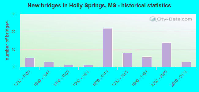
- New bridges - historical statistics
- 51930-1939
- 31940-1949
- 11950-1959
- 11960-1969
- 221970-1979
- 81980-1989
- 61990-1999
- 142000-2009
- 32010-2019


- Bridge Condition - Deck
- 53.1%Good
- 15.6%Satisfactory
- 12.5%Fair
- 18.8%Poor

- Bridge Condition - Superstructure
- 18.8%Very good
- 50.0%Good
- 9.4%Satisfactory
- 6.3%Fair
- 15.6%Poor

- Bridge Condition - Substructure
- 21.9%Very good
- 50.0%Good
- 12.5%Satisfactory
- 3.1%Fair
- 6.3%Poor
- 6.3%Serious

- Bridge Condition - Channel
- 5.3%Very good
- 55.3%Good
- 31.6%Satisfactory
- 7.9%Fair

- Bridge Condition - Culverts
- 73.7%Good
- 26.3%Satisfactory
Find on map >> Show street view
Structure Number: SA4700000000154, Location: SEC 15 T 3S R 2W B (Lat: 34.829328, Lng: -89.405303), Route carried "on" structure: County highway 52, Year Built: 1997, Status: Posted for load, Structure Length: 1.86m (6.10ft), Average Daily Traffic: 85 (year 2013), Average Future Daily Traffic: 120 (year 2038), Features Intersected: COLDWATER RIVER, Facility Carried by Structure: OLD HUDSONVILLE RD
Minimum Vertical Clearance: 30+ m (98+ ft), Kilometerpoint: 6.838, Lanes on structure: 2, Owner: County Highway Agency, Approaching Roadway Width: 7.9m (25.9ft), Material/Design: Steel, Design/Construction: Box Beam or Girders - Multiple, Number Of Spans In Main Unit: 1, Length of Maximum Span: 18.1m (59.4ft), Curb-To-Curb Width: 7.4m (24.3ft), Out-to-Out Width: 7.4m (24.3ft)
Condition: Deck: Satisfactory, Superstructure: Satisfactory, Substructure: Satisfactory, Channel: Good, Operating Rating: 26.5 metric tons, Method Used To Determine Operating Rating: Load Factor (LF), Inventory Rating: 16.0 metric tons, Method Used To Determine Inventory Rating: Load Factor (LF), Structural Evaluation: Meets minimum limits, Deck Geometry: Equal to present minimum criteria, Waterway Adequacy: Equal to present desirable criteria, Approach Roadway Alignment: Equal to present minimum criteria, Bridge Posting: Required (Relationship of Operating Rating to Maximum Legal Load: 10.0 - 19.9% below), Length Of Structure Improvement: 2.58m (8.46ft), Designated Inspection Frequency: Every 24 months, Critical Feature Inspection Frequency: Every 24 months, Inspection Date: November 2021, Critical Feature Inspection Date: November 2021, Bridge Improvement Cost: $139,000, Roadway Improvement Cost: $35,000, Total Project Cost: $209,000 ( Estimate for 2015), Deck Structure Type: Wood or Timber, Wearing Surface/Protective System: Wearing Surface: Gravel
Find on map >> Show street view
Structure Number: SA470000000016, Location: SEC 26 T 3S R 3W (Lat: 34.798456, Lng: -89.489181), Route carried "on" structure: County highway , Year Built: 2006, Status: Open, Structure Length: 4.59m (15.06ft), Average Daily Traffic: 2,000 (year 2018), Truck Traffic: 10%, Average Future Daily Traffic: 3,000 (year 2038), Design Load: HS 20, Features Intersected: SR 178, Facility Carried by Structure: NORTH ACCESS ROAD
Minimum Vertical Clearance: 30+ m (98+ ft), Kilometerpoint: 2.164, Lanes on structure: 2, Lanes under structure: 2, Owner: County Highway Agency, Approaching Roadway Width: 12.0m (39.4ft), Material/Design: Prestressed concrete, Design/Construction: Stringer/Multi-beam, Number Of Spans In Main Unit: 3, Length of Maximum Span: 24.3m (79.7ft), Curb or Sidewalk Widths: Left: 0.4m (1.3ft), Right: 0.4m (1.3ft), Curb-To-Curb Width: 12.2m (40.0ft), Out-to-Out Width: 13.1m (43.0ft)
Condition: Deck: Good, Superstructure: Very good, Substructure: Good, Operating Rating: 57.7 metric tons, Method Used To Determine Operating Rating: Load Factor (LF) rating reported by rating factor (RF) method using MS18 loading, Inventory Rating: 27.9 metric tons, Method Used To Determine Inventory Rating: Load Factor (LF) rating reported by rating factor (RF) method using MS18 loading, Structural Evaluation: Better than present minimum criteria, Deck Geometry: Better than present minimum criteria, Underclear: High priority of corrective action, Approach Roadway Alignment: Equal to present minimum criteria, Designated Inspection Frequency: Every 24 months, Inspection Date: March 2020, Deck Structure Type: Concrete Cast-file-Place, Wearing Surface/Protective System: Wearing Surface: Monolithic Concrete
Find on map >> Show street view
Structure Number: SA4700000000161, Location: SEC 26 T 3S R 3W (Lat: 34.798225, Lng: -89.487792), Route carried "on" structure: County highway , Year Built: 2006, Status: Open, Structure Length: 0.70m (2.30ft), Average Daily Traffic: 1,000 (year 2018), Truck Traffic: 10%, Average Future Daily Traffic: 1,500 (year 2038), Design Load: HS 20, Features Intersected: CREEK, Facility Carried by Structure: NORTH ACCESS ROAD
Minimum Vertical Clearance: 30+ m (98+ ft), Kilometerpoint: 2.980, Lanes on structure: 2, Owner: County Highway Agency, Approaching Roadway Width: 12.0m (39.4ft), Material/Design: Concrete, Design/Construction: Culvert, Number Of Spans In Main Unit: 2, Length of Maximum Span: 3.0m (9.8ft)
Condition: Channel: Good, Culverts: Good, Operating Rating: 89.1 metric tons, Method Used To Determine Operating Rating: Load Factor (LF) rating reported by rating factor (RF) method using MS18 loading, Inventory Rating: 53.5 metric tons, Method Used To Determine Inventory Rating: Load Factor (LF) rating reported by rating factor (RF) method using MS18 loading, Structural Evaluation: Better than present minimum criteria, Waterway Adequacy: Superior to present desirable criteria, Approach Roadway Alignment: Equal to present minimum criteria, Designated Inspection Frequency: Every 24 months, Inspection Date: March 2020
Find on map >> Show street view
Structure Number: SA4700000000162, Location: SEC 26 T 3S R 3W (Lat: 34.800203, Lng: -89.487572), Route carried "on" structure: County highway , Year Built: 2006, Status: Open, Structure Length: 6.00m (19.69ft), Average Daily Traffic: 2,000 (year 2016), Truck Traffic: 10%, Average Future Daily Traffic: 3,000 (year 2036), Design Load: HS 20, Features Intersected: BNSF RAILROAD, Facility Carried by Structure: NORTH ACCESS ROAD
Minimum Vertical Clearance: 30+ m (98+ ft), Kilometerpoint: 4.506, Lanes on structure: 2, Owner: County Highway Agency, Approaching Roadway Width: 12.0m (39.4ft), Skew: 2 degrees, Material/Design: Prestressed concrete, Design/Construction: Stringer/Multi-beam, Number Of Spans In Main Unit: 3, Length of Maximum Span: 24.0m (78.7ft), Curb or Sidewalk Widths: Left: 0.4m (1.3ft), Right: 0.4m (1.3ft), Curb-To-Curb Width: 13.3m (43.6ft), Out-to-Out Width: 14.2m (46.6ft)
Condition: Deck: Good, Superstructure: Very good, Substructure: Very good, Operating Rating: 59.6 metric tons, Method Used To Determine Operating Rating: Load Factor (LF) rating reported by rating factor (RF) method using MS18 loading, Inventory Rating: 29.5 metric tons, Method Used To Determine Inventory Rating: Load Factor (LF) rating reported by rating factor (RF) method using MS18 loading, Structural Evaluation: Better than present minimum criteria, Deck Geometry: Better than present minimum criteria, Underclear: Superior to present desirable criteria, Approach Roadway Alignment: Equal to present minimum criteria, Designated Inspection Frequency: Every 24 months, Inspection Date: January 2021, Deck Structure Type: Concrete Cast-file-Place, Wearing Surface/Protective System: Wearing Surface: Monolithic Concrete
Find on map >> Show street view
Structure Number: SA4700000000163, Location: SEC 26 T 3S R 3W (Lat: 34.798958, Lng: -89.488731), Route carried "on" structure: County highway , Year Built: 2006, Status: Open, Structure Length: 0.68m (2.23ft), Average Daily Traffic: 2,000 (year 2018), Truck Traffic: 10%, Average Future Daily Traffic: 3,000 (year 2038), Design Load: HS 20, Features Intersected: CREEK, Facility Carried by Structure: NORTH ACCESS ROAD
Minimum Vertical Clearance: 30+ m (98+ ft), Kilometerpoint: 1.550, Lanes on structure: 2, Owner: County Highway Agency, Approaching Roadway Width: 6.9m (22.6ft), Material/Design: Concrete, Design/Construction: Culvert, Number Of Spans In Main Unit: 2, Length of Maximum Span: 3.0m (9.8ft)
Condition: Channel: Good, Culverts: Good, Operating Rating: 43.2 metric tons, Method Used To Determine Operating Rating: Allowable Stress (AS), Inventory Rating: 32.4 metric tons, Method Used To Determine Inventory Rating: Allowable Stress (AS), Structural Evaluation: Better than present minimum criteria, Waterway Adequacy: Superior to present desirable criteria, Approach Roadway Alignment: Equal to present minimum criteria, Designated Inspection Frequency: Every 24 months, Inspection Date: March 2020
Find on map >> Show street view
Structure Number: SA4700000000168, Location: SEC 7 T 4S R 2W (Lat: 34.753925, Lng: -89.461381), Route carried "on" structure: City street , Year Built: 2007, Status: Open, Structure Length: 0.73m (2.40ft), Average Daily Traffic: 300 (year 2018), Truck Traffic: 2%, Average Future Daily Traffic: 450 (year 2038), Design Load: HS 20, Features Intersected: CREEK, Facility Carried by Structure: CRESCENT MEADOW DR
Minimum Vertical Clearance: 30+ m (98+ ft), Kilometerpoint: 0.804, Lanes on structure: 2, Owner: City or Municipal Highway Agency, Approaching Roadway Width: 10.9m (35.8ft), Material/Design: Concrete, Design/Construction: Culvert, Number Of Spans In Main Unit: 2, Length of Maximum Span: 3.6m (11.8ft), Curb or Sidewalk Widths: Left: 0.2m (0.7ft), Right: 0.2m (0.7ft), Curb-To-Curb Width: 12.2m (40.0ft), Out-to-Out Width: 12.2m (40.0ft)
Condition: Channel: Good, Culverts: Satisfactory, Operating Rating: 62.2 metric tons, Method Used To Determine Operating Rating: Load Factor (LF) rating reported by rating factor (RF) method using MS18 loading, Inventory Rating: 37.3 metric tons, Method Used To Determine Inventory Rating: Load Factor (LF) rating reported by rating factor (RF) method using MS18 loading, Structural Evaluation: Equal to present minimum criteria, Deck Geometry: Superior to present desirable criteria, Waterway Adequacy: Better than present minimum criteria, Approach Roadway Alignment: Equal to present desirable criteria, Designated Inspection Frequency: Every 24 months, Inspection Date: March 2021
Find on map >> Show street view
Structure Number: SA4700000000169, Location: SEC 7 T 4S R 2W (Lat: 34.754861, Lng: -89.457664), Route carried "on" structure: City street , Year Built: 2009, Status: Open, Structure Length: 0.92m (3.02ft), Average Daily Traffic: 1,000 (year 2018), Truck Traffic: 4%, Average Future Daily Traffic: 1,500 (year 2038), Design Load: HS 20, Features Intersected: CREEK, Facility Carried by Structure: WEST BOUNDARY ST
Minimum Vertical Clearance: 30+ m (98+ ft), Kilometerpoint: 0.402, Lanes on structure: 2, Owner: City or Municipal Highway Agency, Approaching Roadway Width: 10.9m (35.8ft), Skew: 3 degrees, Material/Design: Concrete, Design/Construction: Culvert, Number Of Spans In Main Unit: 2, Length of Maximum Span: 4.6m (15.1ft), Curb or Sidewalk Widths: Left: 0.2m (0.7ft), Right: 0.2m (0.7ft), Curb-To-Curb Width: 12.2m (40.0ft), Out-to-Out Width: 12.2m (40.0ft)
Condition: Channel: Good, Culverts: Good, Operating Rating: 60.9 metric tons, Method Used To Determine Operating Rating: Load Factor (LF) rating reported by rating factor (RF) method using MS18 loading, Inventory Rating: 36.6 metric tons, Method Used To Determine Inventory Rating: Load Factor (LF) rating reported by rating factor (RF) method using MS18 loading, Structural Evaluation: Better than present minimum criteria, Deck Geometry: Equal to present desirable criteria, Waterway Adequacy: Better than present minimum criteria, Approach Roadway Alignment: Equal to present desirable criteria, Designated Inspection Frequency: Every 24 months, Inspection Date: March 2021
Find on map >> Show street view
Structure Number: SA470000000017, Location: SEC 7 T 4S R 2W (Lat: 34.754864, Lng: -89.455078), Route carried "on" structure: City street , Year Built: 2009, Status: Open, Structure Length: 0.67m (2.20ft), Average Daily Traffic: 500 (year 2018), Truck Traffic: 2%, Average Future Daily Traffic: 750 (year 2038), Design Load: HS 20, Features Intersected: CREEK, Facility Carried by Structure: MARY RAHE DRIVE
Minimum Vertical Clearance: 30+ m (98+ ft), Kilometerpoint: 0.209, Lanes on structure: 2, Owner: City or Municipal Highway Agency, Approaching Roadway Width: 10.9m (35.8ft), Skew: 2 degrees, Material/Design: Concrete, Design/Construction: Culvert, Number Of Spans In Main Unit: 1, Length of Maximum Span: 6.7m (22.0ft), Curb or Sidewalk Widths: Left: 0.2m (0.7ft), Right: 0.2m (0.7ft), Curb-To-Curb Width: 12.2m (40.0ft), Out-to-Out Width: 12.2m (40.0ft)
Condition: Channel: Good, Culverts: Satisfactory, Operating Rating: 58.6 metric tons, Method Used To Determine Operating Rating: Load Factor (LF) rating reported by rating factor (RF) method using MS18 loading, Inventory Rating: 35.0 metric tons, Method Used To Determine Inventory Rating: Load Factor (LF) rating reported by rating factor (RF) method using MS18 loading, Structural Evaluation: Equal to present minimum criteria, Deck Geometry: Equal to present desirable criteria, Waterway Adequacy: Better than present minimum criteria, Approach Roadway Alignment: Equal to present minimum criteria, Designated Inspection Frequency: Every 24 months, Inspection Date: March 2021
Find on map >> Show street view
Structure Number: 21000780470312A, Location: US 78 OVER SR 4/ SR 7 (Lat: 34.747689, Lng: -89.454369), Route carried "under" structure: US 4, Year Built: 1975, Structure Length: 0. m, Average Daily Traffic: 5,000 (year 2017), Truck Traffic: 12%, Features Intersected: SR 4/SR 7, Facility Carried by Structure: US 78
Minimum Vertical Clearance: 5.81m (19.06ft), Kilometerpoint: 24.617, Lanes on structure: 2, Lanes under structure: 4, Material/Design: Prestressed concrete continuous, Design/Construction: Stringer/Multi-beam, Length of Maximum Span: 28.3m (92.8ft)
Find on map >> Show street view
Structure Number: 21000780470312A, Location: US 78 OVER SR 4/ SR 7 (Lat: 34.747850, Lng: -89.454611), Route carried "under" structure: State highway 4, Year Built: 1975, Structure Length: 0. m, Average Daily Traffic: 5,000 (year 2017), Truck Traffic: 12%, Features Intersected: SR 4/SR 7, Facility Carried by Structure: US 78
Minimum Vertical Clearance: 5.58m (18.31ft), Kilometerpoint: 0.328, Lanes on structure: 2, Lanes under structure: 4, Material/Design: Prestressed concrete continuous, Design/Construction: Stringer/Multi-beam, Length of Maximum Span: 28.3m (92.8ft)
Find on map >> Show street view
Structure Number: 21000780470312B, Location: US 78 OVER SR 4/SR 7 (Lat: 34.747439, Lng: -89.454481), Route carried "under" structure: State highway 4, Year Built: 1975, Structure Length: 0. m, Average Daily Traffic: 5,000 (year 2017), Truck Traffic: 12%, Features Intersected: SR 4/SR 7, Facility Carried by Structure: US 78
Minimum Vertical Clearance: 5.23m (17.16ft), Kilometerpoint: 24.588, Lanes on structure: 2, Lanes under structure: 4, Material/Design: Prestressed concrete continuous, Design/Construction: Stringer/Multi-beam, Length of Maximum Span: 28.3m (92.8ft)
Find on map >> Show street view
Structure Number: 21000780470312B, Location: US 78 OVER SR 4/SR 7 (Lat: 34.747600, Lng: -89.454719), Route carried "under" structure: State highway 4, Year Built: 1975, Structure Length: 0. m, Average Daily Traffic: 5,000 (year 2017), Truck Traffic: 12%, Features Intersected: SR 4/SR 7, Facility Carried by Structure: US 78
Minimum Vertical Clearance: 5.00m (16.40ft), Kilometerpoint: 0.357, Lanes on structure: 2, Lanes under structure: 4, Material/Design: Prestressed concrete continuous, Design/Construction: Stringer/Multi-beam, Length of Maximum Span: 28.3m (92.8ft)
Find on map >> Show street view
Structure Number: 21000780470322, Location: 1.0 MI SE SR 7 (Lat: 34.739281, Lng: -89.441889), Route carried "under" structure: Interstate 22, Year Built: 1975, Structure Length: 0. m, Average Daily Traffic: 8,500 (year 2017), Truck Traffic: 17%, Features Intersected: I 22, Facility Carried by Structure: MISS CENTRAL RR
Minimum Vertical Clearance: 5.02m (16.47ft), Kilometerpoint: 17.222, Lanes under structure: 4, Material/Design: Steel, Design/Construction: Stringer/Multi-beam, Length of Maximum Span: 27.7m (90.9ft)
Find on map >> Show street view
Structure Number: 21000780470322, Location: 1.0 MI SE SR 7 (Lat: 34.739050, Lng: -89.442011), Route carried "under" structure: Interstate 22, Year Built: 1975, Structure Length: 0. m, Average Daily Traffic: 8,500 (year 2017), Truck Traffic: 17%, Features Intersected: I 22, Facility Carried by Structure: MISS CENTRAL RR
Minimum Vertical Clearance: 5.02m (16.47ft), Kilometerpoint: 31.614, Lanes under structure: 4, Material/Design: Steel, Design/Construction: Stringer/Multi-beam, Length of Maximum Span: 27.7m (90.9ft)
Find on map >> Show street view
Structure Number: 4100078047025, Location: 13.1 MI E DESOTO CL (Lat: 34.806842, Lng: -89.511186), Route carried "under" structure: Interstate 22, Year Built: 1987, Structure Length: 0. m, Average Daily Traffic: 12,500 (year 2017), Truck Traffic: 17%, Features Intersected: I 22, Facility Carried by Structure: BICYCLE ROAD
Minimum Vertical Clearance: 5.16m (16.93ft), Kilometerpoint: 2.845, Lanes on structure: 2, Lanes under structure: 4, Material/Design: Prestressed concrete, Design/Construction: Stringer/Multi-beam, Length of Maximum Span: 30.5m (100.1ft)
Find on map >> Show street view
Structure Number: 4100078047025, Location: 13.1 MI E DESOTO CL (Lat: 34.806842, Lng: -89.511186), Route carried "under" structure: Interstate 22, Year Built: 1987, Structure Length: 0. m, Average Daily Traffic: 12,500 (year 2017), Truck Traffic: 17%, Features Intersected: I 22, Facility Carried by Structure: BICYCLE ROAD
Minimum Vertical Clearance: 5.61m (18.41ft), Kilometerpoint: 2.845, Lanes on structure: 2, Lanes under structure: 4, Material/Design: Prestressed concrete, Design/Construction: Stringer/Multi-beam, Length of Maximum Span: 30.5m (100.1ft)
Find on map >> Show street view
Structure Number: 41000780470295, Location: 1.7 MI W SR 7 (Lat: 34.767931, Lng: -89.469489), Route carried "under" structure: US 78, Year Built: 1975, Structure Length: 0. m, Average Daily Traffic: 10,500 (year 2017), Truck Traffic: 17%, Features Intersected: US 78, Facility Carried by Structure: HERNANDO ROAD
Minimum Vertical Clearance: 5.01m (16.44ft), Kilometerpoint: 0.002, Lanes on structure: 2, Lanes under structure: 4, Material/Design: Prestressed concrete, Design/Construction: Stringer/Multi-beam, Length of Maximum Span: 32.6m (107.0ft)
Find on map >> Show street view
Structure Number: 41000780470295, Location: 1.7 MI W SR 7 (Lat: 34.767931, Lng: -89.469489), Route carried "under" structure: US 78, Year Built: 1975, Structure Length: 0. m, Average Daily Traffic: 10,500 (year 2017), Truck Traffic: 17%, Features Intersected: US 78, Facility Carried by Structure: HERNANDO ROAD
Minimum Vertical Clearance: 6.32m (20.73ft), Kilometerpoint: 0.002, Lanes on structure: 2, Lanes under structure: 4, Material/Design: Prestressed concrete, Design/Construction: Stringer/Multi-beam, Length of Maximum Span: 32.6m (107.0ft)
Find on map >> Show street view
Structure Number: 410007804703, Location: 1.2 MI W SR 7 (Lat: 34.760711, Lng: -89.466861), Route carried "under" structure: Interstate 22, Year Built: 1975, Structure Length: 0. m, Average Daily Traffic: 10,500 (year 2017), Truck Traffic: 17%, Features Intersected: I 22, Facility Carried by Structure: PEYTON ROAD
Minimum Vertical Clearance: 5.41m (17.75ft), Kilometerpoint: 20.612, Lanes on structure: 2, Lanes under structure: 4, Material/Design: Prestressed concrete continuous, Design/Construction: Stringer/Multi-beam, Length of Maximum Span: 27.7m (90.9ft)
Find on map >> Show street view
Structure Number: 410007804703, Location: 1.2 MI W SR 7 (Lat: 34.760600, Lng: -89.467131), Route carried "under" structure: Interstate 22, Year Built: 1975, Structure Length: 0. m, Average Daily Traffic: 10,500 (year 2017), Truck Traffic: 17%, Features Intersected: I 22, Facility Carried by Structure: PEYTON ROAD
Minimum Vertical Clearance: 5.03m (16.50ft), Kilometerpoint: 28.204, Lanes on structure: 2, Lanes under structure: 4, Material/Design: Prestressed concrete continuous, Design/Construction: Stringer/Multi-beam, Length of Maximum Span: 27.7m (90.9ft)