Bridge Statistics for Hoover, Alabama (AL)
Condition, Traffic, Stress, Structural Evaluation, Project Costs
- National Bridge Inventory (NBI) Statistics
- 97Number of bridges
- 2,034ft / 620mTotal length
- $298,088,000Total costs
- 3,091,276Total average daily traffic
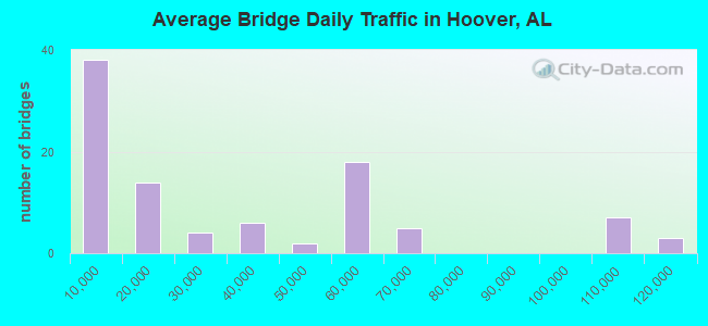
- 361,645Total average daily truck traffic
- National Bridge Inventory (NBI) Registered Bridges for Hoover
- No street view available for this location
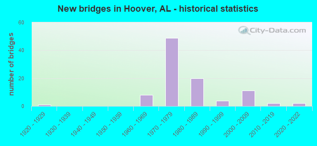
- New bridges - historical statistics
- 11920-1929
- 81960-1969
- 491970-1979
- 201980-1989
- 41990-1999
- 112000-2009
- 22010-2019
- 22020-2022
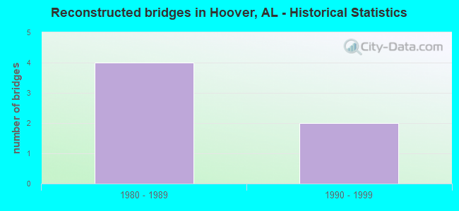
- Reconstructed bridges - Historical Statistics
- 41980-1989
- 21990-1999
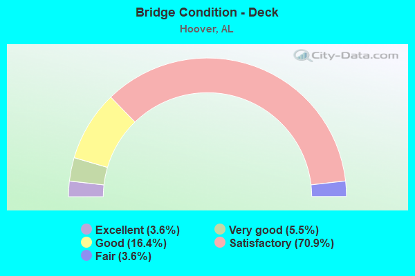
- Bridge Condition - Deck
- 3.6%Excellent
- 5.5%Very good
- 16.4%Good
- 70.9%Satisfactory
- 3.6%Fair
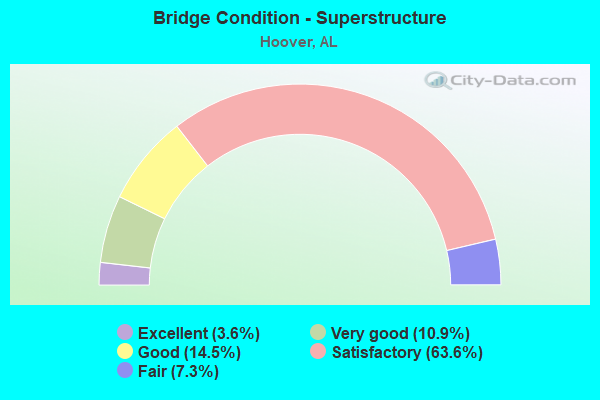
- Bridge Condition - Superstructure
- 3.6%Excellent
- 10.9%Very good
- 14.5%Good
- 63.6%Satisfactory
- 7.3%Fair
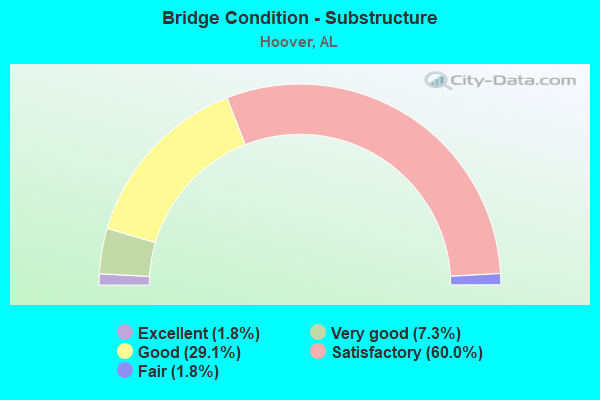
- Bridge Condition - Substructure
- 1.8%Excellent
- 7.3%Very good
- 29.1%Good
- 60.0%Satisfactory
- 1.8%Fair
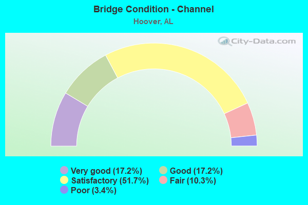
- Bridge Condition - Channel
- 17.2%Very good
- 17.2%Good
- 51.7%Satisfactory
- 10.3%Fair
- 3.4%Poor
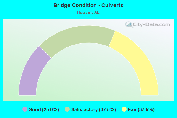
- Bridge Condition - Culverts
- 25.0%Good
- 37.5%Satisfactory
- 37.5%Fair
Find on map >> Show street view
Structure Number: 12913, Location: SOU RR * I459 (Lat: 33.343533, Lng: -86.877644), Route carried "on" structure: Interstate 459, Year Built: 1983, Status: Open, Structure Length: 13.75m (45.11ft), Average Daily Traffic: 27,200 (year 2021), Truck Traffic: 20%, Average Future Daily Traffic: 34,392 (year 2041), Design Load: HS 20, Features Intersected: SCL RR * ACCESS RD
Minimum Vertical Clearance: 30+ m (98+ ft), Kilometerpoint: 14.305, Lanes on structure: 3, Lanes under structure: 2, Base Highway Network: Yes, Owner: State Highway Agency, Approaching Roadway Width: 18.9m (62.0ft), Material/Design: Steel continuous, Design/Construction: Stringer/Multi-beam, Number Of Spans In Main Unit: 4, Number Of Approach Spans: 1, Length of Maximum Span: 33.5m (109.9ft), Curb-To-Curb Width: 17.1m (56.1ft), Out-to-Out Width: 17.6m (57.7ft)
Condition: Deck: Satisfactory, Superstructure: Satisfactory, Substructure: Good, Operating Rating: 88.9 metric tons, Method Used To Determine Operating Rating: Load Factor (LF), Inventory Rating: 64.9 metric tons, Method Used To Determine Inventory Rating: Load Factor (LF), Structural Evaluation: Equal to present minimum criteria, Deck Geometry: Equal to present minimum criteria, Underclear: Superior to present desirable criteria, Approach Roadway Alignment: Better than present minimum criteria, Length Of Structure Improvement: 14.55m (47.74ft), Designated Inspection Frequency: Every 24 months, Inspection Date: Febuary 2021, Bridge Improvement Cost: $5,688,000, Roadway Improvement Cost: $569,000, Total Project Cost: $6,257,000 ( Estimate for 2022), Deck Structure Type: Concrete Cast-file-Place
Find on map >> Show street view
Structure Number: 14022, Location: SHELBY/JEFFCO.LINE (Lat: 33.363169, Lng: -86.813119), Route carried "on" structure: County highway 275, Year Built: 1986, Status: Open, Structure Length: 14.08m (46.19ft), Average Daily Traffic: 16,877 (year 2021), Truck Traffic: 10%, Average Future Daily Traffic: 23,630 (year 2041), Design Load: HS 20, Features Intersected: CAHABA RIVER
Minimum Vertical Clearance: 30+ m (98+ ft), Kilometerpoint: 0.010, Lanes on structure: 2, Owner: County Highway Agency, Approaching Roadway Width: 7.3m (24.0ft), Material/Design: Prestressed concrete, Design/Construction: Stringer/Multi-beam, Number Of Spans In Main Unit: 1, Number Of Approach Spans: 5, Length of Maximum Span: 31.4m (103.0ft), Curb-To-Curb Width: 11.2m (36.7ft), Out-to-Out Width: 11.8m (38.7ft)
Condition: Deck: Satisfactory, Superstructure: Satisfactory, Substructure: Good, Channel: Fair, Operating Rating: 56.9 metric tons, Method Used To Determine Operating Rating: Load Factor (LF), Inventory Rating: 34.0 metric tons, Method Used To Determine Inventory Rating: Load Factor (LF), Structural Evaluation: Equal to present minimum criteria, Deck Geometry: Meets minimum limits, Waterway Adequacy: Superior to present desirable criteria, Approach Roadway Alignment: Equal to present desirable criteria, Length Of Structure Improvement: 14.88m (48.82ft), Designated Inspection Frequency: Every 24 months, Inspection Date: October 2021, Bridge Improvement Cost: $3,876,000, Roadway Improvement Cost: $388,000, Total Project Cost: $4,264,000 ( Estimate for 2022), Deck Structure Type: Concrete Cast-file-Place
Find on map >> Show street view
Structure Number: 14421, Location: I 65 * BLUE RIDGE BLVD (Lat: 33.427603, Lng: -86.820875), Route carried "on" structure: Interstate 65, Year Built: 1972, Year Reconstructed: 1988, Status: Open, Structure Length: 4.94m (16.21ft), Average Daily Traffic: 58,955 (year 2020), Truck Traffic: 10%, Average Future Daily Traffic: 74,691 (year 2040), Design Load: HS 20, Features Intersected: BLUE RIDGE BLVD
Minimum Vertical Clearance: 30+ m (98+ ft), Kilometerpoint: 407.768, Lanes on structure: 4, Lanes under structure: 2, Base Highway Network: Yes, Owner: State Highway Agency, Approaching Roadway Width: 18.9m (62.0ft), Material/Design: Steel continuous, Design/Construction: Stringer/Multi-beam, Number Of Spans In Main Unit: 3, Length of Maximum Span: 20.7m (67.9ft), Curb-To-Curb Width: 20.7m (67.9ft), Out-to-Out Width: 22.6m (74.1ft)
Condition: Deck: Satisfactory, Superstructure: Satisfactory, Substructure: Satisfactory, Operating Rating: 64.4 metric tons, Method Used To Determine Operating Rating: Load Factor (LF), Inventory Rating: 38.6 metric tons, Method Used To Determine Inventory Rating: Load Factor (LF), Structural Evaluation: Equal to present minimum criteria, Deck Geometry: Equal to present minimum criteria, Underclear: Equal to present desirable criteria, Approach Roadway Alignment: Better than present minimum criteria, Length Of Structure Improvement: 5.95m (19.52ft), Designated Inspection Frequency: Every 24 months, Inspection Date: March 2020, Bridge Improvement Cost: $3,020,000, Roadway Improvement Cost: $302,000, Total Project Cost: $3,322,000 ( Estimate for 2022), Deck Structure Type: Concrete Cast-file-Place
Find on map >> Show street view
Structure Number: 14422, Location: I 65 * BLUE RIDGE BLVD (Lat: 33.427881, Lng: -86.820242), Route carried "on" structure: Interstate 65, Year Built: 1972, Year Reconstructed: 1988, Status: Open, Structure Length: 5.70m (18.70ft), Average Daily Traffic: 58,955 (year 2020), Truck Traffic: 10%, Average Future Daily Traffic: 74,691 (year 2040), Design Load: HS 20, Features Intersected: BLUE RIDGE BLVD
Minimum Vertical Clearance: 30+ m (98+ ft), Kilometerpoint: 407.768, Lanes on structure: 4, Lanes under structure: 2, Base Highway Network: Yes, Owner: State Highway Agency, Approaching Roadway Width: 18.9m (62.0ft), Material/Design: Steel continuous, Design/Construction: Stringer/Multi-beam, Number Of Spans In Main Unit: 3, Length of Maximum Span: 21.6m (70.9ft), Curb-To-Curb Width: 18.3m (60.0ft), Out-to-Out Width: 20.2m (66.3ft)
Condition: Deck: Satisfactory, Superstructure: Satisfactory, Substructure: Satisfactory, Operating Rating: 50.7 metric tons, Method Used To Determine Operating Rating: Load Factor (LF), Inventory Rating: 30.4 metric tons, Method Used To Determine Inventory Rating: Load Factor (LF), Structural Evaluation: Equal to present minimum criteria, Deck Geometry: Meets minimum limits, Underclear: Equal to present desirable criteria, Approach Roadway Alignment: Equal to present desirable criteria, Length Of Structure Improvement: 6.74m (22.11ft), Designated Inspection Frequency: Every 24 months, Inspection Date: March 2020, Bridge Improvement Cost: $3,048,000, Roadway Improvement Cost: $305,000, Total Project Cost: $3,353,000 ( Estimate for 2022), Deck Structure Type: Concrete Cast-file-Place
Find on map >> Show street view
Structure Number: 14423, Location: I 65 * FORREST BROOK DR (Lat: 33.438908, Lng: -86.823414), Route carried "on" structure: Interstate 65, Year Built: 1972, Year Reconstructed: 1988, Status: Open, Structure Length: 7.28m (23.88ft), Average Daily Traffic: 60,340 (year 2020), Truck Traffic: 10%, Average Future Daily Traffic: 76,446 (year 2040), Design Load: HS 20, Features Intersected: FORREST BROOK DRIVE
Minimum Vertical Clearance: 30+ m (98+ ft), Kilometerpoint: 409.135, Lanes on structure: 3, Lanes under structure: 2, Base Highway Network: Yes, Owner: State Highway Agency, Approaching Roadway Width: 15.8m (51.8ft), Skew: 3 degrees, Material/Design: Steel continuous, Design/Construction: Stringer/Multi-beam, Number Of Spans In Main Unit: 3, Length of Maximum Span: 28.3m (92.8ft), Curb-To-Curb Width: 17.1m (56.1ft), Out-to-Out Width: 18.9m (62.0ft)
Condition: Deck: Satisfactory, Superstructure: Satisfactory, Substructure: Satisfactory, Operating Rating: 53.3 metric tons, Method Used To Determine Operating Rating: Load Factor (LF), Inventory Rating: 31.9 metric tons, Method Used To Determine Inventory Rating: Load Factor (LF), Structural Evaluation: Equal to present minimum criteria, Deck Geometry: Equal to present minimum criteria, Underclear: Superior to present desirable criteria, Approach Roadway Alignment: Equal to present desirable criteria, Length Of Structure Improvement: 8.31m (27.26ft), Designated Inspection Frequency: Every 24 months, Inspection Date: April 2020, Bridge Improvement Cost: $3,534,000, Roadway Improvement Cost: $353,000, Total Project Cost: $3,887,000 ( Estimate for 2022), Deck Structure Type: Concrete Cast-file-Place
Find on map >> Show street view
Structure Number: 14424, Location: I 65 * FORREST BROOK DR (Lat: 33.438992, Lng: -86.823100), Route carried "on" structure: Interstate 65, Year Built: 1972, Year Reconstructed: 1988, Status: Open, Structure Length: 6.31m (20.70ft), Average Daily Traffic: 60,340 (year 2020), Truck Traffic: 10%, Average Future Daily Traffic: 76,446 (year 2040), Design Load: HS 20, Features Intersected: FORREST BROOK DRIVE
Minimum Vertical Clearance: 30+ m (98+ ft), Kilometerpoint: 409.135, Lanes on structure: 3, Lanes under structure: 2, Base Highway Network: Yes, Owner: State Highway Agency, Approaching Roadway Width: 17.1m (56.1ft), Skew: 3 degrees, Material/Design: Steel continuous, Design/Construction: Stringer/Multi-beam, Number Of Spans In Main Unit: 3, Length of Maximum Span: 28.3m (92.8ft), Curb-To-Curb Width: 17.1m (56.1ft), Out-to-Out Width: 18.9m (62.0ft)
Condition: Deck: Satisfactory, Superstructure: Satisfactory, Substructure: Satisfactory, Operating Rating: 53.4 metric tons, Method Used To Determine Operating Rating: Load Factor (LF), Inventory Rating: 32.0 metric tons, Method Used To Determine Inventory Rating: Load Factor (LF), Structural Evaluation: Equal to present minimum criteria, Deck Geometry: Equal to present minimum criteria, Underclear: Superior to present desirable criteria, Approach Roadway Alignment: Equal to present desirable criteria, Length Of Structure Improvement: 7.35m (24.11ft), Designated Inspection Frequency: Every 24 months, Inspection Date: April 2020, Bridge Improvement Cost: $3,124,000, Roadway Improvement Cost: $312,000, Total Project Cost: $3,436,000 ( Estimate for 2022), Deck Structure Type: Concrete Cast-file-Place
Find on map >> Show street view
Structure Number: 17312, Location: AL 150 OVER PATTON CREEK (Lat: 33.366700, Lng: -86.821900), Route carried "on" structure: State highway 150, Year Built: 1998, Status: Open, Structure Length: 6.10m (20.01ft), Average Daily Traffic: 29,710 (year 2020), Truck Traffic: 7%, Average Future Daily Traffic: 36,252 (year 2040), Design Load: HS 20, Features Intersected: PATTON CREEK
Minimum Vertical Clearance: 30+ m (98+ ft), Kilometerpoint: 17.054, Lanes on structure: 4, Owner: State Highway Agency, Approaching Roadway Width: 20.0m (65.6ft), Material/Design: Prestressed concrete, Design/Construction: Stringer/Multi-beam, Number Of Spans In Main Unit: 3, Length of Maximum Span: 24.4m (80.1ft), Curb-To-Curb Width: 20.7m (67.9ft), Out-to-Out Width: 21.6m (70.9ft)
Condition: Deck: Very good, Superstructure: Good, Substructure: Satisfactory, Channel: Very good, Operating Rating: 79.0 metric tons, Method Used To Determine Operating Rating: Load Factor (LF), Inventory Rating: 39.8 metric tons, Method Used To Determine Inventory Rating: Load Factor (LF), Structural Evaluation: Equal to present minimum criteria, Deck Geometry: Superior to present desirable criteria, Waterway Adequacy: Equal to present minimum criteria, Approach Roadway Alignment: Equal to present desirable criteria, Length Of Structure Improvement: 7.14m (23.43ft), Designated Inspection Frequency: Every 24 months, Inspection Date: April 2020, Bridge Improvement Cost: $3,425,000, Roadway Improvement Cost: $343,000, Total Project Cost: $3,768,000 ( Estimate for 2022), Deck Structure Type: Concrete Cast-file-Place
Find on map >> Show street view
Structure Number: 17655, Location: .8 KM W JCT CO RD 275 (Lat: 33.358056, Lng: -86.809167), Route carried "on" structure: City street 275, Year Built: 1975, Status: Open, Structure Length: 1.46m (4.79ft), Average Daily Traffic: 2,500 (year 2020), Truck Traffic: 1%, Average Future Daily Traffic: 3,500 (year 2040), Features Intersected: BRANCH, Facility Carried by Structure: RIVERCHASE PKWY
Minimum Vertical Clearance: 30+ m (98+ ft), Kilometerpoint: 0.000, Lanes on structure: 2, Owner: City or Municipal Highway Agency, Approaching Roadway Width: 7.3m (24.0ft), Material/Design: Concrete, Design/Construction: Channel Beam, Number Of Spans In Main Unit: 2, Length of Maximum Span: 7.3m (24.0ft), Curb-To-Curb Width: 9.8m (32.2ft), Out-to-Out Width: 10.2m (33.5ft)
Condition: Deck: Good, Superstructure: Good, Substructure: Satisfactory, Channel: Poor, Operating Rating: 43.5 metric tons, Method Used To Determine Operating Rating: Load Factor (LF), Inventory Rating: 26.0 metric tons, Method Used To Determine Inventory Rating: Load Factor (LF), Structural Evaluation: Equal to present minimum criteria, Deck Geometry: Meets minimum limits, Waterway Adequacy: Somewhat better than minimum adequacy, Approach Roadway Alignment: Better than present minimum criteria, Length Of Structure Improvement: 2.14m (7.02ft), Designated Inspection Frequency: Every 24 months, Inspection Date: August 2020, Bridge Improvement Cost: $485,000, Roadway Improvement Cost: $49,000, Total Project Cost: $534,000 ( Estimate for 2022), Deck Structure Type: Concrete Precast Panels
Find on map >> Show street view
Structure Number: 17656, Location: .5 KM NW JCT CO RD 17 (Lat: 33.376944, Lng: -86.775278), Route carried "on" structure: City street 17, Year Built: 1986, Status: Open, Structure Length: 2.83m (9.28ft), Average Daily Traffic: 500 (year 2020), Truck Traffic: 1%, Average Future Daily Traffic: 700 (year 2040), Design Load: H 15, Features Intersected: SOUTHLAKE, Facility Carried by Structure: SOUTHLAKE PARKWAY
Minimum Vertical Clearance: 7.56m (24.80ft), Kilometerpoint: 0.000, Lanes on structure: 2, Owner: City or Municipal Highway Agency, Approaching Roadway Width: 7.3m (24.0ft), Material/Design: Steel, Design/Construction: Culvert, Number Of Spans In Main Unit: 9, Length of Maximum Span: 2.4m (7.9ft), Curb-To-Curb Width: 7.3m (24.0ft), Out-to-Out Width: 7.8m (25.6ft)
Condition: Channel: Good, Culverts: Fair, Operating Rating: 88.9 metric tons, Method Used To Determine Operating Rating: Load Factor (LF), Inventory Rating: 88.9 metric tons, Method Used To Determine Inventory Rating: Load Factor (LF), Structural Evaluation: Somewhat better than minimum adequacy, Deck Geometry: Meets minimum limits, Waterway Adequacy: Equal to present desirable criteria, Approach Roadway Alignment: Equal to present desirable criteria, Length Of Structure Improvement: 3.76m (12.34ft), Designated Inspection Frequency: Every 24 months, Inspection Date: August 2020, Bridge Improvement Cost: $1,301,000, Roadway Improvement Cost: $130,000, Total Project Cost: $1,431,000 ( Estimate for 2022)
Find on map >> Show street view
Structure Number: 17739, Location: LAKE CYRUS PKWY/ AL150 (Lat: 33.357722, Lng: -86.879333), Route carried "on" structure: Alternate City street , Year Built: 1999, Status: Open, Structure Length: 4.27m (14.01ft), Average Daily Traffic: 800 (year 2020), Truck Traffic: 5%, Average Future Daily Traffic: 600 (year 2040), Design Load: HS 20, Features Intersected: SHADES CREEK, Facility Carried by Structure: LAKE CYRUS PKWY
Minimum Vertical Clearance: 30+ m (98+ ft), Kilometerpoint: 0.200, Lanes on structure: 2, Owner: City or Municipal Highway Agency, Approaching Roadway Width: 7.3m (24.0ft), Material/Design: Prestressed concrete, Design/Construction: Stringer/Multi-beam, Number Of Spans In Main Unit: 2, Length of Maximum Span: 29.0m (95.1ft), Curb or Sidewalk Widths: Left: 1.2m (3.9ft), Right: 1.2m (3.9ft), Curb-To-Curb Width: 8.5m (27.9ft), Out-to-Out Width: 11.8m (38.7ft)
Condition: Deck: Very good, Superstructure: Very good, Substructure: Very good, Channel: Satisfactory, Operating Rating: 48.3 metric tons, Method Used To Determine Operating Rating: Load Factor (LF), Inventory Rating: 28.9 metric tons, Method Used To Determine Inventory Rating: Load Factor (LF), Structural Evaluation: Better than present minimum criteria, Deck Geometry: Somewhat better than minimum adequacy, Approach Roadway Alignment: Equal to present minimum criteria, Length Of Structure Improvement: 5.25m (17.22ft), Designated Inspection Frequency: Every 24 months, Inspection Date: August 2020, Bridge Improvement Cost: $1,367,000, Roadway Improvement Cost: $137,000, Total Project Cost: $1,504,000 ( Estimate for 2022), Deck Structure Type: Concrete Cast-file-Place
Find on map >> Show street view
Structure Number: 17783, Location: .1 MI. SO. US 31 (Lat: 33.380147, Lng: -86.813939), Route carried "on" structure: Interstate 459, Year Built: 2002, Status: Open, Structure Length: 28.03m (91.96ft), Average Daily Traffic: 69,970 (year 2020), Truck Traffic: 17%, Average Future Daily Traffic: 88,472 (year 2040), Design Load: HS 20, Features Intersected: I-459 AND RAMP B, Facility Carried by Structure: FLYOVER RAMP A
Minimum Vertical Clearance: 30+ m (98+ ft), Kilometerpoint: 21.646, Lanes on structure: 2, Lanes under structure: 7, Owner: State Highway Agency, Approaching Roadway Width: 11.2m (36.7ft), Skew: 9 degrees, Material/Design: Steel continuous, Design/Construction: Stringer/Multi-beam, Number Of Spans In Main Unit: 4, Length of Maximum Span: 84.8m (278.2ft), Curb-To-Curb Width: 11.2m (36.7ft), Out-to-Out Width: 12.0m (39.4ft)
Condition: Deck: Satisfactory, Superstructure: Good, Substructure: Satisfactory, Operating Rating: 69.9 metric tons, Method Used To Determine Operating Rating: Load Factor (LF), Inventory Rating: 41.9 metric tons, Method Used To Determine Inventory Rating: Load Factor (LF), Structural Evaluation: Equal to present minimum criteria, Deck Geometry: Somewhat better than minimum adequacy, Underclear: Equal to present minimum criteria, Approach Roadway Alignment: Better than present minimum criteria, Length Of Structure Improvement: 28.03m (91.96ft), Designated Inspection Frequency: Every 24 months, Inspection Date: December 2020, Bridge Improvement Cost: $7,496,000, Roadway Improvement Cost: $750,000, Total Project Cost: $8,246,000 ( Estimate for 2022), Deck Structure Type: Concrete Cast-file-Place
Find on map >> Show street view
Structure Number: 17784, Location: .1 MI. SO. US 31 (Lat: 33.380447, Lng: -86.813358), Route carried "on" structure: Ramp Interstate 459, Year Built: 2002, Status: Open, Structure Length: 21.33m (69.98ft), Average Daily Traffic: 6,997 (year 2020), Truck Traffic: 17%, Average Future Daily Traffic: 8,847 (year 2040), Design Load: HS 20, Features Intersected: RAMP C, Facility Carried by Structure: FLYOVER RAMP B
Minimum Vertical Clearance: 30+ m (98+ ft), Kilometerpoint: 21.726, Lanes on structure: 2, Lanes under structure: 2, Owner: State Highway Agency, Approaching Roadway Width: 11.3m (37.1ft), Skew: 9 degrees, Material/Design: Steel continuous, Design/Construction: Stringer/Multi-beam, Number Of Spans In Main Unit: 3, Length of Maximum Span: 91.3m (299.5ft), Curb-To-Curb Width: 11.3m (37.1ft), Out-to-Out Width: 12.2m (40.0ft)
Condition: Deck: Satisfactory, Superstructure: Satisfactory, Substructure: Satisfactory, Operating Rating: 58.1 metric tons, Method Used To Determine Operating Rating: Load Factor (LF), Inventory Rating: 35.7 metric tons, Method Used To Determine Inventory Rating: Load Factor (LF), Structural Evaluation: Equal to present minimum criteria, Deck Geometry: Superior to present desirable criteria, Underclear: Superior to present desirable criteria, Approach Roadway Alignment: Better than present minimum criteria, Length Of Structure Improvement: 21.33m (69.98ft), Designated Inspection Frequency: Every 24 months, Inspection Date: November 2020, Bridge Improvement Cost: $5,850,000, Roadway Improvement Cost: $585,000, Total Project Cost: $6,435,000 ( Estimate for 2022), Deck Structure Type: Concrete Cast-file-Place
Find on map >> Show street view
Structure Number: 17887, Location: CULVERT @ FLYOVER (Lat: 33.380583, Lng: -86.815283), Route carried "on" structure: Ramp Interstate 459, Year Built: 2001, Status: Open, Structure Length: 1.04m (3.41ft), Average Daily Traffic: 6,997 (year 2021), Truck Traffic: 17%, Average Future Daily Traffic: 8,847 (year 2041), Design Load: HS 20, Features Intersected: PATTON CK, Facility Carried by Structure: FLYOVER B
Minimum Vertical Clearance: 30.18m (99.02ft), Kilometerpoint: 21.581, Lanes on structure: 4, Toll: On toll road, Owner: State Highway Agency, Approaching Roadway Width: 4.5m (14.8ft), Skew: 2 degrees, Material/Design: Concrete, Design/Construction: Culvert, Number Of Spans In Main Unit: 3, Length of Maximum Span: 3.0m (9.8ft), Curb-To-Curb Width: 4.5m (14.8ft), Out-to-Out Width: 304.5m (999.0ft)
Condition: Channel: Very good, Culverts: Satisfactory, Operating Rating: 88.9 metric tons, Method Used To Determine Operating Rating: Load Factor (LF), Inventory Rating: 88.9 metric tons, Method Used To Determine Inventory Rating: Load Factor (LF), Structural Evaluation: Equal to present minimum criteria, Deck Geometry: High priority of replacement, Waterway Adequacy: Equal to present desirable criteria, Approach Roadway Alignment: Equal to present desirable criteria, Length Of Structure Improvement: 1.71m (5.61ft), Designated Inspection Frequency: Every 24 months, Inspection Date: June 2021, Bridge Improvement Cost: $13,923,000, Roadway Improvement Cost: $1,392,000, Total Project Cost: $15,315,000 ( Estimate for 2022)
Find on map >> Show street view
Structure Number: 19453, Location: .1 MI. FROM AL 119 (Lat: 33.411300, Lng: -86.675100), Route carried "on" structure: City street , Year Built: 2003, Status: Open, Structure Length: 0.94m (3.08ft), Average Daily Traffic: 6,500 (year 2020), Truck Traffic: 1%, Average Future Daily Traffic: 9,100 (year 2040), Design Load: H 15, Features Intersected: CAHABA VALLEY CREEK, Facility Carried by Structure: DOUG BAKER BLVD.
Minimum Vertical Clearance: 30+ m (98+ ft), Kilometerpoint: 0.000, Lanes on structure: 2, Owner: City or Municipal Highway Agency, Approaching Roadway Width: 8.5m (27.9ft), Material/Design: Concrete, Design/Construction: Culvert, Number Of Spans In Main Unit: 5, Length of Maximum Span: 1.5m (4.9ft)
Condition: Channel: Satisfactory, Culverts: Good, Operating Rating: 43.5 metric tons, Method Used To Determine Operating Rating: Field evaluation and documented engineering judgment, Inventory Rating: 32.7 metric tons, Method Used To Determine Inventory Rating: Field evaluation and documented engineering judgment, Structural Evaluation: Better than present minimum criteria, Waterway Adequacy: Equal to present desirable criteria, Approach Roadway Alignment: Equal to present desirable criteria, Length Of Structure Improvement: 1.62m (5.31ft), Designated Inspection Frequency: Every 24 months, Inspection Date: August 2020, Bridge Improvement Cost: $822,000, Roadway Improvement Cost: $82,000, Total Project Cost: $904,000 ( Estimate for 2022)
Find on map >> Show street view
Structure Number: 1979, Location: 1 MILE FROM CR 17 (Lat: 33.383069, Lng: -86.756814), Route carried "on" structure: County highway , Year Built: 1960, Status: Open, Structure Length: 1.21m (3.97ft), Average Daily Traffic: 2,000 (year 2020), Truck Traffic: 1%, Average Future Daily Traffic: 2,800 (year 2040), Design Load: HS 20, Features Intersected: INDIAN VALLEY LAKE, Facility Carried by Structure: INDIAN VALLEY ROAD
Minimum Vertical Clearance: 30+ m (98+ ft), Kilometerpoint: 0.000, Lanes on structure: 2, Owner: County Highway Agency, Approaching Roadway Width: 7.3m (24.0ft), Material/Design: Steel, Design/Construction: Culvert, Number Of Spans In Main Unit: 3, Length of Maximum Span: 3.4m (11.2ft)
Condition: Channel: Satisfactory, Culverts: Fair, Operating Rating: 88.9 metric tons, Method Used To Determine Operating Rating: Load Factor (LF), Inventory Rating: 88.9 metric tons, Method Used To Determine Inventory Rating: Load Factor (LF), Structural Evaluation: Somewhat better than minimum adequacy, Waterway Adequacy: Better than present minimum criteria, Approach Roadway Alignment: Equal to present desirable criteria, Length Of Structure Improvement: 1.89m (6.20ft), Designated Inspection Frequency: Every 24 months, Inspection Date: August 2020, Bridge Improvement Cost: $839,000, Roadway Improvement Cost: $84,000, Total Project Cost: $923,000 ( Estimate for 2022)
Find on map >> Show street view
Structure Number: 198, Location: ROSS BRIDGE (Lat: 33.374572, Lng: -86.860033), Route carried "on" structure: City street , Year Built: 2005, Status: Open, Structure Length: 2.54m (8.33ft), Average Daily Traffic: 1,200 (year 2020), Truck Traffic: 1%, Average Future Daily Traffic: 1,680 (year 2040), Design Load: HS 20, Features Intersected: UT TO SHADES CREEK, Facility Carried by Structure: ORCHARD AVENUE
Minimum Vertical Clearance: 30+ m (98+ ft), Kilometerpoint: 0.000, Lanes on structure: 2, Owner: City or Municipal Highway Agency, Approaching Roadway Width: 7.3m (24.0ft), Skew: 1 degrees, Material/Design: Prestressed concrete, Design/Construction: Stringer/Multi-beam, Number Of Spans In Main Unit: 1, Length of Maximum Span: 25.4m (83.3ft), Curb or Sidewalk Widths: Left: 2.1m (6.9ft), Right: 0.0m, Curb-To-Curb Width: 10.9m (35.8ft), Out-to-Out Width: 14.0m (45.9ft)
Condition: Deck: Good, Superstructure: Very good, Substructure: Good, Channel: Very good, Operating Rating: 82.5 metric tons, Method Used To Determine Operating Rating: Load Factor (LF), Inventory Rating: 61.2 metric tons, Method Used To Determine Inventory Rating: Load Factor (LF), Structural Evaluation: Better than present minimum criteria, Deck Geometry: Equal to present minimum criteria, Waterway Adequacy: Equal to present desirable criteria, Approach Roadway Alignment: Equal to present desirable criteria, Length Of Structure Improvement: 3.43m (11.25ft), Designated Inspection Frequency: Every 24 months, Inspection Date: August 2020, Bridge Improvement Cost: $1,081,000, Roadway Improvement Cost: $108,000, Total Project Cost: $1,189,000 ( Estimate for 2022), Deck Structure Type: Concrete Cast-file-Place
Find on map >> Show street view
Structure Number: 19892, Location: ROSS BRIDGE (Lat: 33.373972, Lng: -86.861722), Route carried "on" structure: City street , Year Built: 2005, Status: Open, Structure Length: 13.87m (45.51ft), Average Daily Traffic: 4,700 (year 2020), Truck Traffic: 3%, Average Future Daily Traffic: 6,580 (year 2040), Design Load: HS 20, Features Intersected: SHADES CREEK, Facility Carried by Structure: ROSS BRIDGE PKWY
Minimum Vertical Clearance: 30+ m (98+ ft), Kilometerpoint: 0.000, Lanes on structure: 2, Owner: City or Municipal Highway Agency, Approaching Roadway Width: 7.3m (24.0ft), Skew: 1 degrees, Material/Design: Prestressed concrete, Design/Construction: Stringer/Multi-beam, Number Of Spans In Main Unit: 3, Number Of Approach Spans: 2, Length of Maximum Span: 33.6m (110.2ft), Curb or Sidewalk Widths: Left: 2.1m (6.9ft), Right: 0.0m, Curb-To-Curb Width: 12.2m (40.0ft), Out-to-Out Width: 15.8m (51.8ft)
Condition: Deck: Good, Superstructure: Good, Substructure: Good, Channel: Satisfactory, Operating Rating: 70.1 metric tons, Method Used To Determine Operating Rating: Load Factor (LF), Inventory Rating: 38.0 metric tons, Method Used To Determine Inventory Rating: Load Factor (LF), Structural Evaluation: Better than present minimum criteria, Deck Geometry: Equal to present minimum criteria, Waterway Adequacy: Superior to present desirable criteria, Approach Roadway Alignment: Equal to present desirable criteria, Length Of Structure Improvement: 14.67m (48.13ft), Designated Inspection Frequency: Every 24 months, Inspection Date: August 2020, Bridge Improvement Cost: $5,131,000, Roadway Improvement Cost: $513,000, Total Project Cost: $5,644,000 ( Estimate for 2022), Deck Structure Type: Concrete Cast-file-Place
Find on map >> Show street view
Structure Number: 20158, Location: ROSS BRIDGE (Lat: 33.394389, Lng: -86.872889), Route carried "on" structure: City street , Year Built: 2005, Status: Open, Structure Length: 4.26m (13.98ft), Average Daily Traffic: 4,700 (year 2020), Truck Traffic: 3%, Average Future Daily Traffic: 6,580 (year 2040), Design Load: HS 20, Features Intersected: CSX RR, Facility Carried by Structure: ROSS BRIDGE PKWY
Minimum Vertical Clearance: 30+ m (98+ ft), Kilometerpoint: 0.000, Lanes on structure: 2, Owner: City or Municipal Highway Agency, Approaching Roadway Width: 7.3m (24.0ft), Skew: 3 degrees, Material/Design: Prestressed concrete, Design/Construction: Stringer/Multi-beam, Number Of Spans In Main Unit: 1, Number Of Approach Spans: 1, Length of Maximum Span: 28.4m (93.2ft), Curb or Sidewalk Widths: Left: 2.1m (6.9ft), Right: 0.0m, Curb-To-Curb Width: 12.8m (42.0ft), Out-to-Out Width: 15.8m (51.8ft)
Condition: Deck: Satisfactory, Superstructure: Very good, Substructure: Good, Operating Rating: 57.5 metric tons, Method Used To Determine Operating Rating: Load Factor (LF), Inventory Rating: 34.5 metric tons, Method Used To Determine Inventory Rating: Load Factor (LF), Structural Evaluation: Better than present minimum criteria, Deck Geometry: Equal to present desirable criteria, Underclear: Superior to present desirable criteria, Approach Roadway Alignment: Equal to present desirable criteria, Length Of Structure Improvement: 5.23m (17.16ft), Designated Inspection Frequency: Every 24 months, Inspection Date: August 2020, Bridge Improvement Cost: $1,828,000, Roadway Improvement Cost: $183,000, Total Project Cost: $2,011,000 ( Estimate for 2022), Deck Structure Type: Concrete Cast-file-Place
Find on map >> Show street view
Structure Number: 20486, Location: 1.25 MI W. of US 31 (Lat: 33.388967, Lng: -86.827267), Route carried "on" structure: County highway 512, Year Built: 2020, Status: Open, Structure Length: 3.32m (10.89ft), Average Daily Traffic: 1,200 (year 2020), Truck Traffic: 2%, Average Future Daily Traffic: 1,680 (year 2040), Design Load: HS 20, Features Intersected: Patton Creek, Facility Carried by Structure: Patton Chapel Rd
Minimum Vertical Clearance: 30+ m (98+ ft), Kilometerpoint: 0.000, Lanes on structure: 2, Owner: City or Municipal Highway Agency, Approaching Roadway Width: 7.3m (24.0ft), Material/Design: Concrete, Design/Construction: Stringer/Multi-beam, Number Of Spans In Main Unit: 3, Length of Maximum Span: 11.1m (36.4ft), Curb or Sidewalk Widths: Left: 0.0m, Right: 2.1m (6.9ft), Curb-To-Curb Width: 12.2m (40.0ft), Out-to-Out Width: 15.1m (49.5ft)
Condition: Deck: Excellent, Superstructure: Excellent, Substructure: Excellent, Channel: Very good, Operating Rating: 70.2 metric tons, Method Used To Determine Operating Rating: Load Factor (LF), Inventory Rating: 42.1 metric tons, Method Used To Determine Inventory Rating: Load Factor (LF), Structural Evaluation: Superior to present desirable criteria, Deck Geometry: High priority of replacement, Waterway Adequacy: Equal to present desirable criteria, Approach Roadway Alignment: Equal to present desirable criteria, Length Of Structure Improvement: 4.20m (13.78ft), Designated Inspection Frequency: Every 24 months, Inspection Date: November 2020, Bridge Improvement Cost: $1,411,000, Roadway Improvement Cost: $141,000, Total Project Cost: $1,552,000 ( Estimate for 2022), Deck Structure Type: Concrete Cast-file-Place, Wearing Surface/Protective System: Wearing Surface: Monolithic Concrete
Find on map >> Show street view
Structure Number: 20814, Location: 0.4 MILES FROM GALLERIA (Lat: 33.366844, Lng: -86.821608), Route carried "on" structure: City street , Year Built: 2013, Status: Open, Structure Length: 36.27m (119.00ft), Average Daily Traffic: 1,000 (year 2020), Truck Traffic: 2%, Average Future Daily Traffic: 1,400 (year 2040), Design Load: HS 20, Features Intersected: PATTON CREEK, Facility Carried by Structure: CHAPEL LANE
Minimum Vertical Clearance: 8.15m (26.74ft), Kilometerpoint: 0.000, Lanes on structure: 2, Owner: City or Municipal Highway Agency, Approaching Roadway Width: 11.0m (36.1ft), Skew: 9 degrees, Material/Design: Steel continuous, Design/Construction: Stringer/Multi-beam, Number Of Spans In Main Unit: 3, Number Of Approach Spans: 13, Length of Maximum Span: 39.6m (129.9ft), Curb or Sidewalk Widths: Left: 0.0m, Right: 1.9m (6.2ft), Curb-To-Curb Width: 13.4m (44.0ft), Out-to-Out Width: 16.3m (53.5ft)
Condition: Deck: Good, Superstructure: Very good, Substructure: Good, Channel: Good, Operating Rating: 47.0 metric tons, Method Used To Determine Operating Rating: Load Factor (LF), Inventory Rating: 28.1 metric tons, Method Used To Determine Inventory Rating: Load Factor (LF), Structural Evaluation: Better than present minimum criteria, Deck Geometry: High priority of replacement, Waterway Adequacy: Equal to present desirable criteria, Approach Roadway Alignment: Equal to present desirable criteria, Length Of Structure Improvement: 36.27m (119.00ft), Designated Inspection Frequency: Every 24 months, Inspection Date: August 2020, Bridge Improvement Cost: $13,182,000, Roadway Improvement Cost: $1,318,000, Total Project Cost: $14,500,000 ( Estimate for 2022), Deck Structure Type: Concrete Cast-file-Place
Find on map >> Show street view
Structure Number: 20989, Location: 0.3 MILE FROM AL 119 (Lat: 33.425292, Lng: -86.663667), Route carried "on" structure: City street , Year Built: 1995, Status: Open, Structure Length: 0.91m (2.99ft), Average Daily Traffic: 1,800 (year 2020), Truck Traffic: 1%, Average Future Daily Traffic: 2,520 (year 2040), Design Load: HS 20, Features Intersected: UNNAMED CREEK, Facility Carried by Structure: GREYSTONE WAY
Minimum Vertical Clearance: 30+ m (98+ ft), Kilometerpoint: 0.000, Lanes on structure: 2, Owner: City or Municipal Highway Agency, Approaching Roadway Width: 9.8m (32.2ft), Skew: 4 degrees, Material/Design: Concrete, Design/Construction: Culvert, Number Of Spans In Main Unit: 2, Length of Maximum Span: 4.5m (14.8ft)
Condition: Channel: Good, Culverts: Good, Operating Rating: 59.7 metric tons, Method Used To Determine Operating Rating: Load Factor (LF), Inventory Rating: 35.8 metric tons, Method Used To Determine Inventory Rating: Load Factor (LF), Structural Evaluation: Better than present minimum criteria, Waterway Adequacy: Better than present minimum criteria, Approach Roadway Alignment: Equal to present desirable criteria, Length Of Structure Improvement: 1.57m (5.15ft), Designated Inspection Frequency: Every 24 months, Inspection Date: August 2020, Bridge Improvement Cost: $508,000, Roadway Improvement Cost: $51,000, Total Project Cost: $559,000 ( Estimate for 2022)
Find on map >> Show street view
Structure Number: 21075, Location: _creekside subdivision (Lat: 33.334867, Lng: -86.868417), Route carried "on" structure: City street , Year Built: 2007, Status: Open, Structure Length: 3.05m (10.01ft), Average Daily Traffic: 400 (year 2020), Truck Traffic: 1%, Average Future Daily Traffic: 560 (year 2040), Design Load: HS 20, Features Intersected: _Black Creek, Facility Carried by Structure: _Creekside drive
Minimum Vertical Clearance: 30+ m (98+ ft), Kilometerpoint: 0.000, Lanes on structure: 2, Owner: City or Municipal Highway Agency, Approaching Roadway Width: 6.7m (22.0ft), Material/Design: Prestressed concrete, Design/Construction: Stringer/Multi-beam, Number Of Spans In Main Unit: 1, Length of Maximum Span: 30.5m (100.1ft), Curb or Sidewalk Widths: Left: 1.7m (5.6ft), Right: 0.0m, Curb-To-Curb Width: 8.5m (27.9ft), Out-to-Out Width: 11.6m (38.1ft)
Condition: Deck: Good, Superstructure: Very good, Substructure: Good, Channel: Satisfactory, Operating Rating: 86.4 metric tons, Method Used To Determine Operating Rating: Load Factor (LF), Inventory Rating: 41.8 metric tons, Method Used To Determine Inventory Rating: Load Factor (LF), Structural Evaluation: Better than present minimum criteria, Deck Geometry: Equal to present minimum criteria, Waterway Adequacy: Equal to present desirable criteria, Approach Roadway Alignment: Equal to present desirable criteria, Length Of Structure Improvement: 3.89m (12.76ft), Designated Inspection Frequency: Every 24 months, Inspection Date: August 2020, Bridge Improvement Cost: $1,014,000, Roadway Improvement Cost: $101,000, Total Project Cost: $1,115,000 ( Estimate for 2022), Deck Structure Type: Concrete Cast-file-Place
Find on map >> Show street view
Structure Number: 214, Location: _Stadium Trace / CSX RR (Lat: 33.325972, Lng: -86.868750), Route carried "on" structure: City street , Year Built: 2017, Status: Open, Structure Length: 3.54m (11.61ft), Average Daily Traffic: 1,000 (year 2020), Truck Traffic: 1%, Average Future Daily Traffic: 6,300 (year 2040), Design Load: HS 20, Features Intersected: CSX RR, Facility Carried by Structure: STADIUM TRACE PKWY
Minimum Vertical Clearance: 30+ m (98+ ft), Kilometerpoint: 0.000, Lanes on structure: 2, Owner: City or Municipal Highway Agency, Approaching Roadway Width: 7.3m (24.0ft), Material/Design: Prestressed concrete, Design/Construction: Stringer/Multi-beam, Number Of Spans In Main Unit: 1, Length of Maximum Span: 35.4m (116.1ft), Curb or Sidewalk Widths: Left: 1.8m (5.9ft), Right: 0.0m, Curb-To-Curb Width: 9.1m (29.9ft), Out-to-Out Width: 11.8m (38.7ft)
Condition: Deck: Very good, Superstructure: Very good, Substructure: Very good, Operating Rating: 88.9 metric tons, Method Used To Determine Operating Rating: Load Factor (LF), Inventory Rating: 39.5 metric tons, Method Used To Determine Inventory Rating: Load Factor (LF), Structural Evaluation: Equal to present desirable criteria, Deck Geometry: Equal to present minimum criteria, Underclear: High priority of corrective action, Approach Roadway Alignment: Somewhat better than minimum adequacy, Length Of Structure Improvement: 4.44m (14.57ft), Designated Inspection Frequency: Every 24 months, Inspection Date: August 2020, Bridge Improvement Cost: $1,157,000, Roadway Improvement Cost: $116,000, Total Project Cost: $1,273,000 ( Estimate for 2022), Deck Structure Type: Concrete Cast-file-Place
Find on map >> Show street view
Structure Number: 2164, Location: Elvira road over CSX (Lat: 33.306189, Lng: -86.879694), Route carried "on" structure: City street , Year Built: 2021, Status: Open, Structure Length: 4.89m (16.04ft), Average Daily Traffic: 300 (year 2021), Truck Traffic: 1%, Average Future Daily Traffic: 420 (year 2041), Design Load: HS 20, Features Intersected: CSX Railroad, Facility Carried by Structure: Blackridge Dr.
Minimum Vertical Clearance: 30+ m (98+ ft), Kilometerpoint: 0.000, Lanes on structure: 2, Owner: City or Municipal Highway Agency, Approaching Roadway Width: 7.3m (24.0ft), Material/Design: Concrete, Design/Construction: Stringer/Multi-beam, Number Of Spans In Main Unit: 1, Length of Maximum Span: 48.9m (160.4ft), Curb or Sidewalk Widths: Left: 1.8m (5.9ft), Right: 0.0m, Curb-To-Curb Width: 9.1m (29.9ft), Out-to-Out Width: 11.8m (38.7ft)
Condition: Deck: Excellent, Superstructure: Excellent, Substructure: Very good, Operating Rating: 88.9 metric tons, Method Used To Determine Operating Rating: Load Factor (LF), Inventory Rating: 23.1 metric tons, Method Used To Determine Inventory Rating: Load Factor (LF), Structural Evaluation: Equal to present minimum criteria, Deck Geometry: Equal to present minimum criteria, Underclear: High priority of replacement, Approach Roadway Alignment: Equal to present minimum criteria, Length Of Structure Improvement: 5.91m (19.39ft), Designated Inspection Frequency: Every 24 months, Inspection Date: June 2021, Bridge Improvement Cost: $1,539,000, Roadway Improvement Cost: $154,000, Total Project Cost: $1,693,000 ( Estimate for 2022), Deck Structure Type: Concrete Cast-file-Place, Wearing Surface/Protective System: Wearing Surface: Monolithic Concrete
Find on map >> Show street view
Structure Number: 11743, Location: I 459 * US 31 (Lat: 33.384800, Lng: -86.806300), Route carried "under" structure: US 31, Year Built: 1977, Structure Length: 0. m, Average Daily Traffic: 35,670 (year 2020), Truck Traffic: 5%, Features Intersected: AL - 3 (US 31), Facility Carried by Structure: I - 459 SOUTH
Minimum Vertical Clearance: 5.03m (16.50ft), Kilometerpoint: 426.478, Lanes on structure: 3, Lanes under structure: 4, Material/Design: Steel continuous, Design/Construction: Stringer/Multi-beam, Length of Maximum Span: 36.6m (120.1ft)
Find on map >> Show street view
Structure Number: 11744, Location: I459 * US31 (Lat: 33.384200, Lng: -86.806900), Route carried "under" structure: US 31, Year Built: 1977, Structure Length: 0. m, Average Daily Traffic: 35,670 (year 2020), Truck Traffic: 5%, Features Intersected: AL - 3 (US 31), Facility Carried by Structure: I - 459 NORTH
Minimum Vertical Clearance: 6.22m (20.41ft), Kilometerpoint: 426.476, Lanes on structure: 5, Lanes under structure: 5, Material/Design: Steel continuous, Design/Construction: Stringer/Multi-beam, Length of Maximum Span: 36.6m (120.1ft)
Find on map >> Show street view
Structure Number: 11745, Location: LORNA RD * I 459 (Lat: 33.389136, Lng: -86.796339), Route carried "under" structure: Interstate 459, Year Built: 1977, Structure Length: 0. m, Average Daily Traffic: 109,630 (year 2021), Truck Traffic: 11%, Features Intersected: I - 459, Facility Carried by Structure: LORNA RD
Minimum Vertical Clearance: 5.18m (16.99ft), Kilometerpoint: 23.508, Lanes on structure: 5, Lanes under structure: 10, Material/Design: Steel continuous, Design/Construction: Stringer/Multi-beam, Length of Maximum Span: 30.5m (100.1ft)
Find on map >> Show street view
Structure Number: 11746, Location: I 65 * I 459 INTERCHANGE (Lat: 33.393358, Lng: -86.785736), Route carried "under" structure: Ramp Interstate 459, Year Built: 1977, Structure Length: 0. m, Average Daily Traffic: 10,364 (year 2020), Truck Traffic: 10%, Features Intersected: RAMPS C*D
Minimum Vertical Clearance: 5.99m (19.65ft), Kilometerpoint: 24.538, Lanes on structure: 3, Lanes under structure: 2, Material/Design: Steel continuous, Design/Construction: Stringer/Multi-beam, Length of Maximum Span: 41.5m (136.2ft)
Find on map >> Show street view
Structure Number: 11747, Location: I 65 * I 459 INTERCHANGE (Lat: 33.392939, Lng: -86.786092), Route carried "under" structure: Ramp Interstate 459, Year Built: 1977, Structure Length: 0. m, Average Daily Traffic: 10,364 (year 2021), Truck Traffic: 10%, Features Intersected: RAMP D
Minimum Vertical Clearance: 6.27m (20.57ft), Kilometerpoint: 24.473, Lanes on structure: 3, Lanes under structure: 1, Material/Design: Steel continuous, Design/Construction: Stringer/Multi-beam, Length of Maximum Span: 41.5m (136.2ft)
Find on map >> Show street view
Structure Number: 11747, Location: I 65 * I 459 INTERCHANGE (Lat: 33.392939, Lng: -86.786092), Route carried "under" structure: Interstate 459, Year Built: 1977, Structure Length: 0. m, Average Daily Traffic: 103,640 (year 2021), Truck Traffic: 10%, Features Intersected: RAMP D
Minimum Vertical Clearance: 5.92m (19.42ft), Kilometerpoint: 24.731, Lanes on structure: 3, Lanes under structure: 1, Material/Design: Steel continuous, Design/Construction: Stringer/Multi-beam, Length of Maximum Span: 41.5m (136.2ft)
Find on map >> Show street view
Structure Number: 11759, Location: I 459/I 65 INTERCHANGE (Lat: 33.392100, Lng: -86.784700), Route carried "under" structure: Interstate 459, Year Built: 1977, Structure Length: 0. m, Average Daily Traffic: 103,640 (year 2020), Truck Traffic: 10%, Features Intersected: I 459, Facility Carried by Structure: I - 65 SOUTH
Minimum Vertical Clearance: 5.61m (18.41ft), Kilometerpoint: 25.328, Lanes on structure: 3, Lanes under structure: 6, Material/Design: Steel continuous, Design/Construction: Stringer/Multi-beam, Length of Maximum Span: 40.1m (131.6ft)
Find on map >> Show street view
Structure Number: 11759, Location: I 459/I 65 INTERCHANGE (Lat: 33.392100, Lng: -86.784700), Route carried "under" structure: Ramp Interstate 459, Year Built: 1977, Structure Length: 0. m, Average Daily Traffic: 10,364 (year 2020), Truck Traffic: 10%, Features Intersected: I 459, Facility Carried by Structure: I - 65 SOUTH
Minimum Vertical Clearance: 5.08m (16.67ft), Kilometerpoint: 25.328, Lanes on structure: 3, Lanes under structure: 2, Material/Design: Steel continuous, Design/Construction: Stringer/Multi-beam, Length of Maximum Span: 40.1m (131.6ft)
Find on map >> Show street view
Structure Number: 1176, Location: I 459/I 65 INTERCHANGE (Lat: 33.392653, Lng: -86.784511), Route carried "under" structure: Interstate 459, Year Built: 1977, Structure Length: 0. m, Average Daily Traffic: 103,640 (year 2020), Truck Traffic: 10%, Features Intersected: I - 459 & RAMPS, Facility Carried by Structure: I - 65 NORTH
Minimum Vertical Clearance: 5.40m (17.72ft), Kilometerpoint: 25.328, Lanes on structure: 3, Lanes under structure: 6, Material/Design: Steel continuous, Design/Construction: Stringer/Multi-beam, Length of Maximum Span: 40.4m (132.5ft)
Find on map >> Show street view
Structure Number: 1176, Location: I 459/I 65 INTERCHANGE (Lat: 33.392653, Lng: -86.784511), Route carried "under" structure: Ramp Interstate 65, Year Built: 1977, Structure Length: 0. m, Average Daily Traffic: 11,363 (year 2020), Truck Traffic: 13%, Features Intersected: I - 459 & RAMPS
Minimum Vertical Clearance: 5.41m (17.75ft), Kilometerpoint: 401.710, Lanes on structure: 3, Lanes under structure: 1, Material/Design: Steel continuous, Design/Construction: Stringer/Multi-beam, Length of Maximum Span: 40.4m (132.5ft)
Find on map >> Show street view
Structure Number: 1176, Location: I 459/I 65 INTERCHANGE (Lat: 33.392653, Lng: -86.784511), Route carried "under" structure: Ramp Interstate 65, Year Built: 1977, Structure Length: 0. m, Average Daily Traffic: 11,363 (year 2020), Truck Traffic: 13%, Features Intersected: I - 459 & RAMPS
Minimum Vertical Clearance: 5.08m (16.67ft), Kilometerpoint: 402.352, Lanes on structure: 3, Lanes under structure: 1, Material/Design: Steel continuous, Design/Construction: Stringer/Multi-beam, Length of Maximum Span: 40.4m (132.5ft)
Find on map >> Show street view
Structure Number: 11761, Location: I 65 I 459 INTERCHANGE (Lat: 33.393025, Lng: -86.784036), Route carried "under" structure: Interstate 65, Year Built: 1977, Structure Length: 0. m, Average Daily Traffic: 113,630 (year 2020), Truck Traffic: 13%, Features Intersected: I 65 I459 AND RAMPS, Facility Carried by Structure: RAMP 61 TO I459 SB
Minimum Vertical Clearance: 5.44m (17.85ft), Kilometerpoint: 401.710, Lanes on structure: 2, Lanes under structure: 6, Material/Design: Steel continuous, Design/Construction: Stringer/Multi-beam, Length of Maximum Span: 42.4m (139.1ft)
Find on map >> Show street view
Structure Number: 11761, Location: I 65 I 459 INTERCHANGE (Lat: 33.393025, Lng: -86.784036), Route carried "under" structure: Ramp Interstate 459, Year Built: 1977, Structure Length: 0. m, Average Daily Traffic: 10,364 (year 2020), Truck Traffic: 10%, Features Intersected: I 65 I459 AND RAMPS
Minimum Vertical Clearance: 5.08m (16.67ft), Kilometerpoint: 25.328, Lanes on structure: 2, Lanes under structure: 2, Material/Design: Steel continuous, Design/Construction: Stringer/Multi-beam, Length of Maximum Span: 42.4m (139.1ft)
Find on map >> Show street view
Structure Number: 11761, Location: I 65 I 459 INTERCHANGE (Lat: 33.393025, Lng: -86.784036), Route carried "under" structure: Interstate 459, Year Built: 1977, Structure Length: 0. m, Average Daily Traffic: 103,640 (year 2020), Truck Traffic: 10%, Features Intersected: I 65 I459 AND RAMPS
Minimum Vertical Clearance: 5.08m (16.67ft), Kilometerpoint: 25.328, Lanes on structure: 2, Lanes under structure: 6, Material/Design: Steel continuous, Design/Construction: Stringer/Multi-beam, Length of Maximum Span: 42.4m (139.1ft)
Find on map >> Show street view
Structure Number: 11762, Location: I 65 I 459 INTERCHANGE (Lat: 33.393489, Lng: -86.783531), Route carried "under" structure: Interstate 65, Year Built: 1977, Structure Length: 0. m, Average Daily Traffic: 113,630 (year 2020), Truck Traffic: 13%, Features Intersected: I 65 HOOVER, Facility Carried by Structure: RAMPS MP249.62
Minimum Vertical Clearance: 5.44m (17.85ft), Kilometerpoint: 401.710, Lanes on structure: 2, Lanes under structure: 6, Material/Design: Steel continuous, Design/Construction: Stringer/Multi-beam, Length of Maximum Span: 42.4m (139.1ft)
Find on map >> Show street view
Structure Number: 11762, Location: I 65 I 459 INTERCHANGE (Lat: 33.393489, Lng: -86.783531), Route carried "under" structure: Interstate 459, Year Built: 1977, Structure Length: 0. m, Average Daily Traffic: 103,640 (year 2020), Truck Traffic: 10%, Features Intersected: I 65 HOOVER, Facility Carried by Structure: RAMPS MP249.62
Minimum Vertical Clearance: 5.08m (16.67ft), Kilometerpoint: 25.328, Lanes on structure: 2, Lanes under structure: 6, Material/Design: Steel continuous, Design/Construction: Stringer/Multi-beam, Length of Maximum Span: 42.4m (139.1ft)
Find on map >> Show street view
Structure Number: 11762, Location: I 65 I 459 INTERCHANGE (Lat: 33.393489, Lng: -86.783531), Route carried "under" structure: Ramp Interstate 459, Year Built: 1977, Structure Length: 0. m, Average Daily Traffic: 10,364 (year 2020), Truck Traffic: 10%, Features Intersected: I 65 HOOVER, Facility Carried by Structure: RAMPS MP249.62
Minimum Vertical Clearance: 5.08m (16.67ft), Kilometerpoint: 25.328, Lanes on structure: 2, Lanes under structure: 2, Material/Design: Steel continuous, Design/Construction: Stringer/Multi-beam, Length of Maximum Span: 42.4m (139.1ft)
Find on map >> Show street view
Structure Number: 11763, Location: I 65 * ROCKY RIDGE ROAD (Lat: 33.401250, Lng: -86.787978), Route carried "under" structure: City street , Year Built: 1977, Structure Length: 0. m, Average Daily Traffic: 1,000 (year 2002), Truck Traffic: 1%, Features Intersected: ROCKY RIDGE ROAD, Facility Carried by Structure: I - 65 SOUTH
Minimum Vertical Clearance: 5.70m (18.70ft), Kilometerpoint: 0.161, Lanes on structure: 4, Lanes under structure: 4, Material/Design: Steel continuous, Design/Construction: Stringer/Multi-beam, Length of Maximum Span: 34.7m (113.8ft)
Find on map >> Show street view
Structure Number: 11764, Location: I 65 * ROCKY RIDGE RD (Lat: 33.401414, Lng: -86.787706), Route carried "under" structure: City street , Year Built: 1977, Structure Length: 0. m, Average Daily Traffic: 1,000 (year 2002), Truck Traffic: 1%, Features Intersected: ROCKY RIDGE RD, Facility Carried by Structure: I - 65 NORTH
Minimum Vertical Clearance: 5.70m (18.70ft), Kilometerpoint: 0.161, Lanes on structure: 4, Lanes under structure: 4, Material/Design: Steel continuous, Design/Construction: Stringer/Multi-beam, Length of Maximum Span: 34.7m (113.8ft)
Find on map >> Show street view
Structure Number: 11765, Location: I 65 * WISTERIA DR (Lat: 33.407036, Lng: -86.795167), Route carried "under" structure: City street , Year Built: 1977, Structure Length: 0. m, Average Daily Traffic: 1,000 (year 2020), Truck Traffic: 9%, Features Intersected: WISTERIA DR, Facility Carried by Structure: I 65
Minimum Vertical Clearance: 12.19m (39.99ft), Kilometerpoint: 0.000, Lanes on structure: 4, Lanes under structure: 2, Material/Design: Steel continuous, Design/Construction: Stringer/Multi-beam, Length of Maximum Span: 33.5m (109.9ft)
Find on map >> Show street view
Structure Number: 11766, Location: I 65 * WISTERIA DR (Lat: 33.407172, Lng: -86.794908), Route carried "under" structure: Alternate City street , Year Built: 1977, Structure Length: 0. m, Average Daily Traffic: 1,000 (year 2020), Features Intersected: WISTERIA DR, Facility Carried by Structure: I 65
Minimum Vertical Clearance: 30+ m (98+ ft), Kilometerpoint: 0.161, Lanes on structure: 4, Lanes under structure: 2, Material/Design: Steel continuous, Design/Construction: Stringer/Multi-beam, Length of Maximum Span: 33.5m (109.9ft)
Find on map >> Show street view
Structure Number: 11932, Location: I 65 * LOWER ROCKY RIDGE (Lat: 33.386217, Lng: -86.783800), Route carried "under" structure: Interstate 65, Year Built: 1978, Structure Length: 0. m, Average Daily Traffic: 113,630 (year 2020), Truck Traffic: 13%, Features Intersected: I 65, Facility Carried by Structure: OLD ROCKY RIDGE RD
Minimum Vertical Clearance: 5.18m (16.99ft), Kilometerpoint: 401.853, Lanes on structure: 2, Lanes under structure: 9, Material/Design: Steel continuous, Design/Construction: Stringer/Multi-beam, Length of Maximum Span: 32.5m (106.6ft)
Find on map >> Show street view
Structure Number: 12295, Location: I459* SULPHUR SPRINGS RD (Lat: 33.360600, Lng: -86.847900), Route carried "under" structure: City street , Year Built: 1980, Structure Length: 0. m, Average Daily Traffic: 5,000 (year 2020), Truck Traffic: 10%, Features Intersected: PRESERVE PARKWAY, Facility Carried by Structure: I - 459 SOUTH
Minimum Vertical Clearance: 7.56m (24.80ft), Kilometerpoint: 0.161, Lanes on structure: 3, Lanes under structure: 4, Material/Design: Steel, Design/Construction: Stringer/Multi-beam, Length of Maximum Span: 28.0m (91.9ft)
Find on map >> Show street view
Structure Number: 12296, Location: I459 * PRESERVE PKWY (Lat: 33.359700, Lng: -86.847000), Route carried "under" structure: City street , Year Built: 1980, Structure Length: 0. m, Average Daily Traffic: 2,000 (year 2020), Truck Traffic: 10%, Features Intersected: PRESERVE PARKWAY, Facility Carried by Structure: I - 459 NORTH
Minimum Vertical Clearance: 30+ m (98+ ft), Kilometerpoint: 0.161, Lanes on structure: 4, Lanes under structure: 2, Material/Design: Prestressed concrete continuous, Design/Construction: Stringer/Multi-beam, Length of Maximum Span: 24.4m (80.1ft)
Find on map >> Show street view
Structure Number: 12326, Location: I 65 * VALLEYDALE RD (Lat: 33.353333, Lng: -86.779444), Route carried "under" structure: County highway 17, Year Built: 1980, Structure Length: 0. m, Average Daily Traffic: 14,000 (year 2021), Truck Traffic: 14%, Features Intersected: CO RD 17, Facility Carried by Structure: I 65 SOUTH
Minimum Vertical Clearance: 5.18m (16.99ft), Kilometerpoint: 0.000, Lanes on structure: 4, Lanes under structure: 6, Material/Design: Steel continuous, Design/Construction: Stringer/Multi-beam, Length of Maximum Span: 33.4m (109.6ft)
Find on map >> Show street view
Structure Number: 12327, Location: I 65 * VALLEYDALE RD (Lat: 33.353500, Lng: -86.779700), Route carried "under" structure: County highway 17, Year Built: 1980, Structure Length: 0. m, Average Daily Traffic: 11,000 (year 2018), Truck Traffic: 14%, Features Intersected: CO RD 17, Facility Carried by Structure: I - 65 NORTH
Minimum Vertical Clearance: 5.18m (16.99ft), Kilometerpoint: 0.000, Lanes on structure: 3, Lanes under structure: 8, Material/Design: Steel continuous, Design/Construction: Stringer/Multi-beam, Length of Maximum Span: 33.7m (110.6ft)
Find on map >> Show street view
Structure Number: 12714, Location: SHADES CREST RD (Lat: 33.345294, Lng: -86.870914), Route carried "under" structure: Interstate 459, Year Built: 1982, Structure Length: 0. m, Average Daily Traffic: 54,400 (year 2019), Truck Traffic: 20%, Features Intersected: I 459, Facility Carried by Structure: SHADES CREST RD
Minimum Vertical Clearance: 14.99m (49.18ft), Kilometerpoint: 14.981, Lanes on structure: 2, Lanes under structure: 6, Material/Design: Steel continuous, Design/Construction: Stringer/Multi-beam, Length of Maximum Span: 33.5m (109.9ft)
Find on map >> Show street view
Structure Number: 12715, Location: I459 * AL 150 (Lat: 33.356736, Lng: -86.852083), Route carried "under" structure: State highway 150, Year Built: 1982, Structure Length: 0. m, Average Daily Traffic: 29,900 (year 2020), Truck Traffic: 7%, Features Intersected: AL 150, Facility Carried by Structure: I 459
Minimum Vertical Clearance: 5.41m (17.75ft), Kilometerpoint: 13.935, Lanes on structure: 3, Lanes under structure: 4, Material/Design: Steel continuous, Design/Construction: Stringer/Multi-beam, Length of Maximum Span: 40.2m (131.9ft)
Find on map >> Show street view
Structure Number: 14421, Location: I 65 * BLUE RIDGE BLVD (Lat: 33.427603, Lng: -86.820875), Route carried "under" structure: ServiceCity street , Year Built: 1972, Structure Length: 0. m, Average Daily Traffic: 300 (year 2020), Truck Traffic: 8%, Features Intersected: BLUE RIDGE BLVD, Facility Carried by Structure: I - 65 SOUTH
Minimum Vertical Clearance: 5.85m (19.19ft), Kilometerpoint: 0.000, Lanes on structure: 4, Lanes under structure: 2, Material/Design: Steel continuous, Design/Construction: Stringer/Multi-beam, Length of Maximum Span: 20.7m (67.9ft)
Find on map >> Show street view
Structure Number: 14422, Location: I 65 * BLUE RIDGE BLVD (Lat: 33.427881, Lng: -86.820242), Route carried "under" structure: ServiceCity street , Year Built: 1972, Structure Length: 0. m, Average Daily Traffic: 300 (year 2020), Truck Traffic: 8%, Features Intersected: BLUE RIDGE BLVD, Facility Carried by Structure: I - 65 NORTH
Minimum Vertical Clearance: 7.50m (24.61ft), Kilometerpoint: 0.000, Lanes on structure: 4, Lanes under structure: 2, Material/Design: Steel continuous, Design/Construction: Stringer/Multi-beam, Length of Maximum Span: 21.6m (70.9ft)
Find on map >> Show street view
Structure Number: 14424, Location: I 65 * FORREST BROOK DR (Lat: 33.438992, Lng: -86.823100), Route carried "under" structure: ServiceCity street , Year Built: 1972, Structure Length: 0. m, Average Daily Traffic: 500 (year 2020), Truck Traffic: 8%, Features Intersected: FORREST BROOK DRIVE, Facility Carried by Structure: I 65
Minimum Vertical Clearance: 5.52m (18.11ft), Kilometerpoint: 0.000, Lanes on structure: 3, Lanes under structure: 2, Material/Design: Steel continuous, Design/Construction: Stringer/Multi-beam, Length of Maximum Span: 28.3m (92.8ft)
Find on map >> Show street view
Structure Number: 17783, Location: .1 MI. SO. US 31 (Lat: 33.380147, Lng: -86.813939), Route carried "under" structure: Interstate 459, Year Built: 2002, Structure Length: 0. m, Average Daily Traffic: 69,970 (year 2020), Truck Traffic: 17%, Features Intersected: I-459 AND RAMP B, Facility Carried by Structure: FLYOVER RAMP A
Minimum Vertical Clearance: 30.18m (99.02ft), Kilometerpoint: 21.613, Lanes on structure: 2, Lanes under structure: 1, Toll: Toll bridge, Material/Design: Steel continuous, Design/Construction: Stringer/Multi-beam, Length of Maximum Span: 84.8m (278.2ft)
Find on map >> Show street view
Structure Number: 17783, Location: .1 MI. SO. US 31 (Lat: 33.380147, Lng: -86.813939), Route carried "under" structure: Ramp Interstate 459, Year Built: 2002, Structure Length: 0. m, Average Daily Traffic: 6,997 (year 2020), Truck Traffic: 17%, Features Intersected: I-459 AND RAMP B, Facility Carried by Structure: FLYOVER RAMP A
Minimum Vertical Clearance: 5.97m (19.59ft), Kilometerpoint: 21.630, Lanes on structure: 2, Lanes under structure: 6, Toll: Toll bridge is a segment, Material/Design: Steel continuous, Design/Construction: Stringer/Multi-beam, Length of Maximum Span: 84.8m (278.2ft)
Find on map >> Show street view
Structure Number: 17784, Location: .1 MI. SO. US 31 (Lat: 33.380447, Lng: -86.813358), Route carried "under" structure: Interstate 459, Year Built: 2002, Structure Length: 0. m, Average Daily Traffic: 69,970 (year 2020), Truck Traffic: 17%, Features Intersected: RAMP C, Facility Carried by Structure: FLYOVER RAMP B
Minimum Vertical Clearance: 6.27m (20.57ft), Kilometerpoint: 21.758, Lanes on structure: 2, Lanes under structure: 2, Toll: Toll bridge is a segment, Material/Design: Steel continuous, Design/Construction: Stringer/Multi-beam, Length of Maximum Span: 91.3m (299.5ft)