Bridge Statistics for Huntington, West Virginia (WV)
Condition, Traffic, Stress, Structural Evaluation, Project Costs
- National Bridge Inventory (NBI) Statistics
- 118Number of bridges
- 2,674ft / 815mTotal length
- $59,595,000Total costs
- 1,120,132Total average daily traffic
- 208,777Total average daily truck traffic
- National Bridge Inventory (NBI) Registered Bridges for Huntington
- No street view available for this location
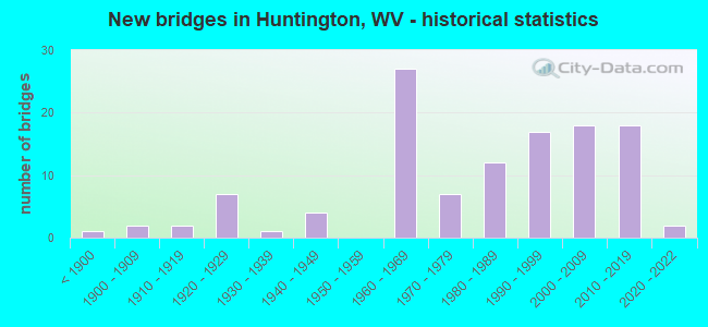
- New bridges - historical statistics
- 1Before 1900
- 21900-1909
- 21910-1919
- 71920-1929
- 11930-1939
- 41940-1949
- 271960-1969
- 71970-1979
- 121980-1989
- 171990-1999
- 182000-2009
- 182010-2019
- 22020-2022
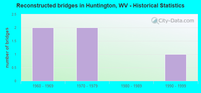
- Reconstructed bridges - Historical Statistics
- 21960-1969
- 21970-1979
- 01980-1989
- 11990-1999
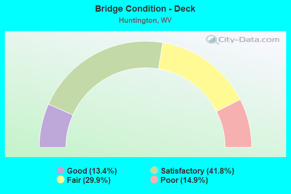
- Bridge Condition - Deck
- 13.4%Good
- 41.8%Satisfactory
- 29.9%Fair
- 14.9%Poor
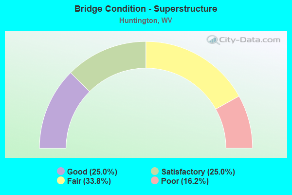
- Bridge Condition - Superstructure
- 25.0%Good
- 25.0%Satisfactory
- 33.8%Fair
- 16.2%Poor
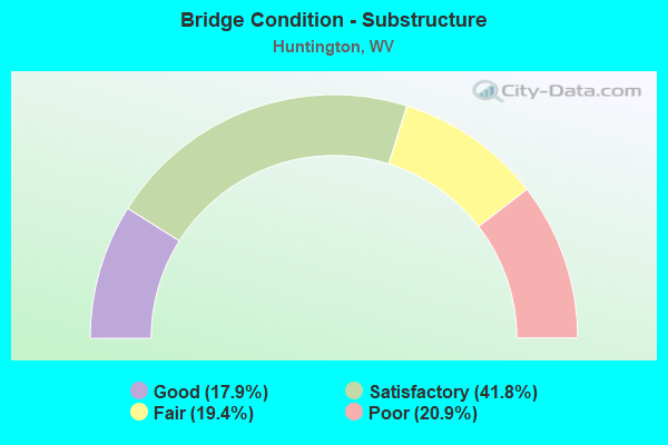
- Bridge Condition - Substructure
- 17.9%Good
- 41.8%Satisfactory
- 19.4%Fair
- 20.9%Poor
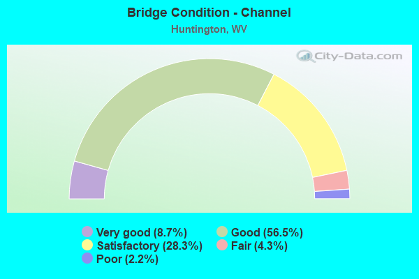
- Bridge Condition - Channel
- 8.7%Very good
- 56.5%Good
- 28.3%Satisfactory
- 4.3%Fair
- 2.2%Poor
Find on map >> Show street view
Structure Number: 6A278, Location: 0.38 MILES WEST OF US 60 (Lat: 38.409500, Lng: -82.353269), Route carried "on" structure: Interstate 6400, Year Built: 2006, Status: Open, Structure Length: 4.43m (14.53ft), Average Daily Traffic: 21,000 (year 2018), Truck Traffic: 17%, Average Future Daily Traffic: 32,340 (year 2038), Design Load: HL 93, Features Intersected: CO RT 60/2 DARNELL RD, Facility Carried by Structure: INTERSTATE 64 WBL
Minimum Vertical Clearance: 30+ m (98+ ft), Kilometerpoint: 22.724, Lanes on structure: 3, Lanes under structure: 2, Base Highway Network: Yes, Owner: State Highway Agency, Approaching Roadway Width: 16.8m (55.1ft), Skew: 3 degrees, Material/Design: Steel continuous, Design/Construction: Stringer/Multi-beam, Number Of Spans In Main Unit: 1, Number Of Approach Spans: 2, Length of Maximum Span: 17.7m (58.1ft), Curb or Sidewalk Widths: Left: 0.6m (2.0ft), Right: 0.4m (1.3ft), Curb-To-Curb Width: 16.8m (55.1ft), Out-to-Out Width: 17.7m (58.1ft)
Condition: Deck: Satisfactory, Superstructure: Good, Substructure: Satisfactory, Operating Rating: 85.3 metric tons, Method Used To Determine Operating Rating: Load and Resistance Factor (LRFR), Inventory Rating: 65.3 metric tons, Method Used To Determine Inventory Rating: Load and Resistance Factor (LRFR), Structural Evaluation: Equal to present minimum criteria, Deck Geometry: Equal to present minimum criteria, Underclear: Meets minimum limits, Approach Roadway Alignment: Better than present minimum criteria, Designated Inspection Frequency: Every 24 months, Inspection Date: June 2020, Deck Structure Type: Concrete Cast-file-Place, Wearing Surface/Protective System: Wearing Surface: Monolithic Concrete, Deck Protection: Epoxy Coated Reinforcing
Find on map >> Show street view
Structure Number: 6A285, Location: 0.17.MILES WEST OF US 52 (Lat: 38.401089, Lng: -82.482911), Route carried "on" structure: Interstate 6400, Year Built: 2007, Status: Open, Structure Length: 7.75m (25.43ft), Average Daily Traffic: 16,200 (year 2020), Truck Traffic: 12%, Average Future Daily Traffic: 23,166 (year 2040), Design Load: HL 93, Features Intersected: 19TH STREET, Facility Carried by Structure: INTERSTATE 64 EB
Minimum Vertical Clearance: 30+ m (98+ ft), Kilometerpoint: 10.107, Lanes on structure: 2, Lanes under structure: 2, Base Highway Network: Yes, Owner: State Highway Agency, Approaching Roadway Width: 16.5m (54.1ft), Material/Design: Prestressed concrete, Design/Construction: Stringer/Multi-beam, Number Of Spans In Main Unit: 1, Number Of Approach Spans: 2, Length of Maximum Span: 31.6m (103.7ft), Curb-To-Curb Width: 16.5m (54.1ft), Out-to-Out Width: 17.3m (56.8ft)
Condition: Deck: Satisfactory, Superstructure: Fair, Substructure: Satisfactory, Operating Rating: 49.0 metric tons, Method Used To Determine Operating Rating: Load and Resistance Factor (LRFR), Inventory Rating: 38.1 metric tons, Method Used To Determine Inventory Rating: Load and Resistance Factor (LRFR), Structural Evaluation: Somewhat better than minimum adequacy, Deck Geometry: Superior to present desirable criteria, Underclear: Meets minimum limits, Approach Roadway Alignment: Equal to present desirable criteria, Designated Inspection Frequency: Every 24 months, Inspection Date: September 2021, Deck Structure Type: Concrete Cast-file-Place, Wearing Surface/Protective System: Wearing Surface: Monolithic Concrete, Deck Protection: Epoxy Coated Reinforcing
Find on map >> Show street view
Structure Number: 6A286, Location: 0.17 MILE WEST OF U S 52 (Lat: 38.401269, Lng: -82.482950), Route carried "on" structure: Interstate 6400, Year Built: 2007, Status: Open, Structure Length: 7.75m (25.43ft), Average Daily Traffic: 16,200 (year 2020), Truck Traffic: 12%, Average Future Daily Traffic: 23,166 (year 2040), Design Load: HL 93, Features Intersected: 19TH STREET, Facility Carried by Structure: INTERSTATE 64 WB
Minimum Vertical Clearance: 30+ m (98+ ft), Kilometerpoint: 10.107, Lanes on structure: 2, Lanes under structure: 2, Base Highway Network: Yes, Owner: State Highway Agency, Approaching Roadway Width: 18.9m (62.0ft), Material/Design: Prestressed concrete, Design/Construction: Stringer/Multi-beam, Number Of Spans In Main Unit: 1, Number Of Approach Spans: 2, Length of Maximum Span: 31.6m (103.7ft), Curb-To-Curb Width: 18.9m (62.0ft), Out-to-Out Width: 19.7m (64.6ft)
Condition: Deck: Satisfactory, Superstructure: Fair, Substructure: Satisfactory, Operating Rating: 49.9 metric tons, Method Used To Determine Operating Rating: Load and Resistance Factor (LRFR), Inventory Rating: 39.0 metric tons, Method Used To Determine Inventory Rating: Load and Resistance Factor (LRFR), Structural Evaluation: Somewhat better than minimum adequacy, Deck Geometry: Superior to present desirable criteria, Underclear: Meets minimum limits, Approach Roadway Alignment: Equal to present desirable criteria, Designated Inspection Frequency: Every 24 months, Inspection Date: August 2021, Deck Structure Type: Concrete Cast-file-Place, Wearing Surface/Protective System: Wearing Surface: Monolithic Concrete, Deck Protection: Epoxy Coated Reinforcing
Find on map >> Show street view
Structure Number: 6A294, Location: 2.74 miles east of WV 152 (Lat: 38.392911, Lng: -82.406911), Route carried "on" structure: Interstate 6400, Year Built: 2010, Status: Open, Structure Length: 18.42m (60.43ft), Average Daily Traffic: 24,032 (year 2019), Truck Traffic: 17%, Average Future Daily Traffic: 37,010 (year 2039), Design Load: HS 25 or greater, Features Intersected: WV 10; FOUR POLE CREEK, Facility Carried by Structure: I64 EB
Minimum Vertical Clearance: 4.88m (16.01ft), Kilometerpoint: 17.590, Lanes on structure: 2, Lanes under structure: 4, Owner: State Highway Agency, Approaching Roadway Width: 16.5m (54.1ft), Material/Design: Steel continuous, Design/Construction: Stringer/Multi-beam, Number Of Spans In Main Unit: 4, Number Of Approach Spans: 2, Length of Maximum Span: 38.9m (127.6ft), Curb-To-Curb Width: 16.6m (54.5ft), Out-to-Out Width: 17.5m (57.4ft)
Condition: Deck: Satisfactory, Superstructure: Satisfactory, Substructure: Good, Channel: Good, Operating Rating: 42.6 metric tons, Method Used To Determine Operating Rating: Load and Resistance Factor (LRFR), Inventory Rating: 33.6 metric tons, Method Used To Determine Inventory Rating: Load and Resistance Factor (LRFR), Structural Evaluation: Equal to present minimum criteria, Deck Geometry: High priority of corrective action, Underclear: Meets minimum limits, Waterway Adequacy: Equal to present desirable criteria, Approach Roadway Alignment: Equal to present desirable criteria, Designated Inspection Frequency: Every 24 months, Inspection Date: March 2021, Deck Structure Type: Concrete Cast-file-Place, Wearing Surface/Protective System: Wearing Surface: Monolithic Concrete, Membrane: Built-up, Deck Protection: Epoxy Coated Reinforcing
Find on map >> Show street view
Structure Number: 6A296, Location: 2.74 miles east of WV 152 (Lat: 38.392911, Lng: -82.406911), Route carried "on" structure: Interstate 6400, Year Built: 2010, Status: Open, Structure Length: 20.15m (66.11ft), Average Daily Traffic: 24,032 (year 2019), Truck Traffic: 17%, Average Future Daily Traffic: 37,010 (year 2039), Design Load: HS 25 or greater, Features Intersected: WV 10; FOUR POLE CREEK, Facility Carried by Structure: I64 WB
Minimum Vertical Clearance: 4.88m (16.01ft), Kilometerpoint: 17.590, Lanes on structure: 2, Lanes under structure: 4, Owner: State Highway Agency, Approaching Roadway Width: 16.5m (54.1ft), Material/Design: Steel continuous, Design/Construction: Stringer/Multi-beam, Number Of Spans In Main Unit: 4, Number Of Approach Spans: 2, Length of Maximum Span: 44.2m (145.0ft), Curb-To-Curb Width: 16.6m (54.5ft), Out-to-Out Width: 17.5m (57.4ft)
Condition: Deck: Satisfactory, Superstructure: Satisfactory, Substructure: Good, Channel: Good, Operating Rating: 48.1 metric tons, Method Used To Determine Operating Rating: Load and Resistance Factor (LRFR), Inventory Rating: 37.2 metric tons, Method Used To Determine Inventory Rating: Load and Resistance Factor (LRFR), Structural Evaluation: Equal to present minimum criteria, Deck Geometry: High priority of corrective action, Underclear: Meets minimum limits, Waterway Adequacy: Equal to present desirable criteria, Approach Roadway Alignment: Equal to present desirable criteria, Designated Inspection Frequency: Every 24 months, Inspection Date: March 2021, Deck Structure Type: Concrete Cast-file-Place, Wearing Surface/Protective System: Wearing Surface: Monolithic Concrete, Membrane: Built-up, Deck Protection: Epoxy Coated Reinforcing
Find on map >> Show street view
Structure Number: 6A299, Location: 0.08 MILE EAST OF WV 2 (Lat: 38.428219, Lng: -82.391539), Route carried "on" structure: State highway 200, Year Built: 2012, Status: Open, Structure Length: 14.11m (46.29ft), Average Daily Traffic: 7,300 (year 2018), Truck Traffic: 4%, Average Future Daily Traffic: 9,125 (year 2038), Design Load: HL 93, Features Intersected: GUYANDOTTE RIVER, Facility Carried by Structure: WV 2 TRUCK
Minimum Vertical Clearance: 30+ m (98+ ft), Kilometerpoint: 0.129, Lanes on structure: 2, Owner: State Highway Agency, Approaching Roadway Width: 8.2m (26.9ft), Material/Design: Steel continuous, Design/Construction: Stringer/Multi-beam, Number Of Spans In Main Unit: 1, Number Of Approach Spans: 2, Length of Maximum Span: 61.0m (200.1ft), Curb or Sidewalk Widths: Left: 0.3m (1.0ft), Right: 2.7m (8.9ft), Curb-To-Curb Width: 8.2m (26.9ft), Out-to-Out Width: 11.3m (37.1ft)
Condition: Deck: Satisfactory, Superstructure: Good, Substructure: Good, Channel: Good, Operating Rating: 42.6 metric tons, Method Used To Determine Operating Rating: Load and Resistance Factor (LRFR), Inventory Rating: 32.7 metric tons, Method Used To Determine Inventory Rating: Load and Resistance Factor (LRFR), Structural Evaluation: Better than present minimum criteria, Deck Geometry: High priority of replacement, Waterway Adequacy: Equal to present desirable criteria, Approach Roadway Alignment: Superior to present desirable criteria, Length Of Structure Improvement: 14.11m (46.29ft), Designated Inspection Frequency: Every 24 months, Underwater Inspection Frequency: Every 60 months, Inspection Date: Febuary 2020, Underwater Inspection Date: September 2017, Bridge Improvement Cost: $6,000,000, Roadway Improvement Cost: $1,000,000, Total Project Cost: $7,000,000 ( Estimate for 2020), Deck Structure Type: Concrete Cast-file-Place, Wearing Surface/Protective System: Wearing Surface: Monolithic Concrete, Membrane: Other, Deck Protection: Epoxy Coated Reinforcing
Find on map >> Show street view
Structure Number: 6A301, Location: 0.78 MI WEST OF CR 60/2 (Lat: 38.405950, Lng: -82.365731), Route carried "on" structure: Interstate 6400, Year Built: 2014, Status: Open, Structure Length: 3.47m (11.38ft), Average Daily Traffic: 42,325 (year 2019), Truck Traffic: 17%, Average Future Daily Traffic: 65,181 (year 2039), Design Load: HL 93, Features Intersected: CEDAR CREST DRIVE, Facility Carried by Structure: Interstate 64
Minimum Vertical Clearance: 30+ m (98+ ft), Kilometerpoint: 21.469, Lanes on structure: 6, Lanes under structure: 2, Base Highway Network: Yes, Owner: State Highway Agency, Approaching Roadway Width: 16.2m (53.1ft), Skew: 33 degrees, Material/Design: Prestressed concrete, Design/Construction: Tee Beam, Number Of Spans In Main Unit: 1, Length of Maximum Span: 34.4m (112.9ft), Curb-To-Curb Width: 32.1m (105.3ft), Out-to-Out Width: 33.7m (110.6ft)
Condition: Deck: Satisfactory, Superstructure: Good, Substructure: Satisfactory, Operating Rating: 62.6 metric tons, Method Used To Determine Operating Rating: Load and Resistance Factor (LRFR), Inventory Rating: 48.1 metric tons, Method Used To Determine Inventory Rating: Load and Resistance Factor (LRFR), Structural Evaluation: Equal to present minimum criteria, Deck Geometry: Superior to present desirable criteria, Underclear: Superior to present desirable criteria, Approach Roadway Alignment: Equal to present desirable criteria, Designated Inspection Frequency: Every 24 months, Inspection Date: January 2021, Deck Structure Type: Concrete Cast-file-Place, Wearing Surface/Protective System: Wearing Surface: Monolithic Concrete, Deck Protection: Epoxy Coated Reinforcing
Find on map >> Show street view
Structure Number: 6A307, Location: 0.01 MILE WEST OF WV 10 (Lat: 38.393419, Lng: -82.407181), Route carried "on" structure: Ramp Interstate 6400, Year Built: 2014, Status: Open, Structure Length: 3.41m (11.19ft), Average Daily Traffic: 3,738 (year 2016), Truck Traffic: 17%, Average Future Daily Traffic: 5,756 (year 2040), Design Load: HL 93, Features Intersected: FOURPOLE CREEK, Facility Carried by Structure: I 64 WB ENTR RAMP
Minimum Vertical Clearance: 30+ m (98+ ft), Kilometerpoint: 17.574, Lanes on structure: 1, Base Highway Network: Yes, Owner: State Highway Agency, Approaching Roadway Width: 18.3m (60.0ft), Skew: 3 degrees, Material/Design: Steel, Design/Construction: Stringer/Multi-beam, Number Of Spans In Main Unit: 1, Length of Maximum Span: 0.0m, Curb-To-Curb Width: 8.5m (27.9ft), Out-to-Out Width: 9.3m (30.5ft)
Condition: Deck: Good, Superstructure: Good, Substructure: Good, Channel: Good, Operating Rating: 56.1 metric tons, Method Used To Determine Operating Rating: Load and Resistance Factor (LRFR), Inventory Rating: 43.4 metric tons, Method Used To Determine Inventory Rating: Load and Resistance Factor (LRFR), Structural Evaluation: Better than present minimum criteria, Deck Geometry: Superior to present desirable criteria, Waterway Adequacy: Superior to present desirable criteria, Approach Roadway Alignment: Equal to present desirable criteria, Designated Inspection Frequency: Every 24 months, Inspection Date: May 2020, Deck Structure Type: Concrete Cast-file-Place, Wearing Surface/Protective System: Wearing Surface: Monolithic Concrete, Membrane: Epoxy, Deck Protection: Epoxy Coated Reinforcing
Find on map >> Show street view
Structure Number: 6A308, Location: 0.01 miles west of WV 10 (Lat: 38.392639, Lng: -82.404081), Route carried "on" structure: Ramp Interstate 6400, Year Built: 2014, Status: Open, Structure Length: 4.88m (16.01ft), Average Daily Traffic: 3,815 (year 2018), Truck Traffic: 17%, Average Future Daily Traffic: 15,207 (year 2038), Design Load: HL 93, Features Intersected: Four Pole Creek, Facility Carried by Structure: I64 EXIT RAMP
Minimum Vertical Clearance: 30+ m (98+ ft), Kilometerpoint: 17.558, Lanes on structure: 2, Base Highway Network: Yes, Owner: State Highway Agency, Approaching Roadway Width: 13.7m (44.9ft), Skew: 9 degrees, Material/Design: Steel continuous, Design/Construction: Stringer/Multi-beam, Number Of Spans In Main Unit: 1, Length of Maximum Span: 48.2m (158.1ft), Curb-To-Curb Width: 12.8m (42.0ft), Out-to-Out Width: 13.3m (43.6ft)
Condition: Deck: Good, Superstructure: Good, Substructure: Good, Channel: Good, Operating Rating: 71.7 metric tons, Method Used To Determine Operating Rating: Load and Resistance Factor (LRFR), Inventory Rating: 55.3 metric tons, Method Used To Determine Inventory Rating: Load and Resistance Factor (LRFR), Structural Evaluation: Better than present minimum criteria, Deck Geometry: Superior to present desirable criteria, Waterway Adequacy: Better than present minimum criteria, Approach Roadway Alignment: Better than present minimum criteria, Designated Inspection Frequency: Every 24 months, Inspection Date: May 2020, Deck Structure Type: Concrete Cast-file-Place, Wearing Surface/Protective System: Wearing Surface: Monolithic Concrete, Deck Protection: Epoxy Coated Reinforcing
Find on map >> Show street view
Structure Number: 6A311, Location: 1.73 MI WEST OF WV 152 (Lat: 38.401561, Lng: -82.480081), Route carried "on" structure: Interstate 6400, Year Built: 2017, Status: Open, Structure Length: 4.36m (14.30ft), Average Daily Traffic: 18,700 (year 2019), Truck Traffic: 12%, Average Future Daily Traffic: 26,741 (year 2039), Design Load: HL 93, Features Intersected: US 52, Facility Carried by Structure: I 64 EB
Minimum Vertical Clearance: 30+ m (98+ ft), Kilometerpoint: 10.429, Lanes on structure: 3, Lanes under structure: 2, Base Highway Network: Yes, Owner: State Highway Agency, Approaching Roadway Width: 12.8m (42.0ft), Material/Design: Steel continuous, Design/Construction: Stringer/Multi-beam, Number Of Spans In Main Unit: 1, Number Of Approach Spans: 2, Length of Maximum Span: 19.8m (65.0ft), Curb-To-Curb Width: 13.4m (44.0ft), Out-to-Out Width: 14.2m (46.6ft)
Condition: Deck: Good, Superstructure: Good, Substructure: Satisfactory, Operating Rating: 55.3 metric tons, Method Used To Determine Operating Rating: Load and Resistance Factor (LRFR), Inventory Rating: 42.6 metric tons, Method Used To Determine Inventory Rating: Load and Resistance Factor (LRFR), Structural Evaluation: Equal to present minimum criteria, Deck Geometry: High priority of replacement, Underclear: High priority of replacement, Approach Roadway Alignment: Equal to present desirable criteria, Length Of Structure Improvement: 4.42m (14.50ft), Designated Inspection Frequency: Every 24 months, Inspection Date: June 2021, Bridge Improvement Cost: $2,500,000, Roadway Improvement Cost: $500,000, Total Project Cost: $3,000,000 ( Estimate for 2017), Deck Structure Type: Concrete Cast-file-Place, Wearing Surface/Protective System: Deck Protection: Epoxy Coated Reinforcing
Find on map >> Show street view
Structure Number: 6A312, Location: 1.73 MI WEST OF WV 152 (Lat: 38.401769, Lng: -82.480081), Route carried "on" structure: Interstate 6400, Year Built: 2017, Status: Open, Structure Length: 4.36m (14.30ft), Average Daily Traffic: 18,700 (year 2019), Truck Traffic: 12%, Average Future Daily Traffic: 21,019 (year 2039), Design Load: HL 93, Features Intersected: US 52, Facility Carried by Structure: I 64 WB
Minimum Vertical Clearance: 30+ m (98+ ft), Kilometerpoint: 10.380, Lanes on structure: 2, Lanes under structure: 2, Base Highway Network: Yes, Owner: State Highway Agency, Approaching Roadway Width: 8.8m (28.9ft), Material/Design: Steel continuous, Design/Construction: Stringer/Multi-beam, Number Of Spans In Main Unit: 1, Number Of Approach Spans: 2, Length of Maximum Span: 19.8m (65.0ft), Curb-To-Curb Width: 11.6m (38.1ft), Out-to-Out Width: 12.4m (40.7ft)
Condition: Deck: Satisfactory, Superstructure: Good, Substructure: Satisfactory, Operating Rating: 75.3 metric tons, Method Used To Determine Operating Rating: Load and Resistance Factor (LRFR), Inventory Rating: 57.1 metric tons, Method Used To Determine Inventory Rating: Load and Resistance Factor (LRFR), Structural Evaluation: Equal to present minimum criteria, Deck Geometry: Equal to present minimum criteria, Underclear: High priority of corrective action, Approach Roadway Alignment: Equal to present desirable criteria, Length Of Structure Improvement: 4.42m (14.50ft), Designated Inspection Frequency: Every 24 months, Inspection Date: June 2021, Bridge Improvement Cost: $2,500,000, Roadway Improvement Cost: $500,000, Total Project Cost: $3,000,000 ( Estimate for 2017), Deck Structure Type: Concrete Cast-file-Place, Wearing Surface/Protective System: Deck Protection: Epoxy Coated Reinforcing
Find on map >> Show street view
Structure Number: 6A315, Location: 0.16 MI SOUTH OF WV 527 (Lat: 38.394031, Lng: -82.452369), Route carried "on" structure: State highway 15200, Year Built: 2018, Status: Open, Structure Length: 10.62m (34.84ft), Average Daily Traffic: 15,270 (year 2018), Truck Traffic: 4%, Average Future Daily Traffic: 19,087 (year 2038), Design Load: HL 93, Features Intersected: INTERSTATE 64, Facility Carried by Structure: WV ROUTE 152
Minimum Vertical Clearance: 30+ m (98+ ft), Kilometerpoint: 2.060, Lanes on structure: 5, Lanes under structure: 5, Owner: State Highway Agency, Approaching Roadway Width: 22.9m (75.1ft), Skew: 5 degrees, Material/Design: Steel continuous, Design/Construction: Stringer/Multi-beam, Number Of Spans In Main Unit: 2, Number Of Approach Spans: 2, Length of Maximum Span: 33.2m (108.9ft), Curb-To-Curb Width: 22.3m (73.2ft), Out-to-Out Width: 23.0m (75.5ft)
Condition: Deck: Satisfactory, Superstructure: Good, Substructure: Satisfactory, Operating Rating: 40.8 metric tons, Method Used To Determine Operating Rating: Load and Resistance Factor (LRFR), Inventory Rating: 31.7 metric tons, Method Used To Determine Inventory Rating: Load and Resistance Factor (LRFR), Structural Evaluation: Equal to present minimum criteria, Deck Geometry: Equal to present minimum criteria, Underclear: High priority of corrective action, Approach Roadway Alignment: Equal to present minimum criteria, Designated Inspection Frequency: Every 24 months, Inspection Date: May 2020, Deck Structure Type: Concrete Cast-file-Place, Wearing Surface/Protective System: Wearing Surface: Integral Concrete, Deck Protection: Epoxy Coated Reinforcing
Find on map >> Show street view
Structure Number: 6A317, Location: 0.02 MI WEST OF WV 10 (Lat: 38.387539, Lng: -82.392500), Route carried "on" structure: County highway 3900, Year Built: 2019, Status: Open, Structure Length: 2.38m (7.81ft), Average Daily Traffic: 1,196 (year 2019), Truck Traffic: 7%, Average Future Daily Traffic: 1,518 (year 2039), Design Load: HL 93, Features Intersected: Grapevine Branch, Facility Carried by Structure: County Road 39
Minimum Vertical Clearance: 30+ m (98+ ft), Kilometerpoint: 4.764, Lanes on structure: 2, Owner: State Highway Agency, Approaching Roadway Width: 6.1m (20.0ft), Material/Design: Prestressed concrete, Design/Construction: Stringer/Multi-beam, Number Of Spans In Main Unit: 1, Length of Maximum Span: 22.9m (75.1ft), Curb-To-Curb Width: 14.2m (46.6ft), Out-to-Out Width: 14.9m (48.9ft)
Condition: Deck: Good, Superstructure: Good, Substructure: Good, Channel: Very good, Operating Rating: 55.0 metric tons, Method Used To Determine Operating Rating: Load and Resistance Factor (LRFR), Inventory Rating: 33.7 metric tons, Method Used To Determine Inventory Rating: Load and Resistance Factor (LRFR), Structural Evaluation: Better than present minimum criteria, Deck Geometry: Superior to present desirable criteria, Waterway Adequacy: Better than present minimum criteria, Approach Roadway Alignment: Equal to present minimum criteria, Designated Inspection Frequency: Every 24 months, Inspection Date: June 2020, Deck Structure Type: Concrete Cast-file-Place
Find on map >> Show street view
Structure Number: 6A326, Location: 0.25 MI North of CR 35 (Lat: 38.386461, Lng: -82.382039), Route carried "on" structure: State highway 10, Year Built: 2020, Status: Open, Structure Length: 3.46m (11.35ft), Average Daily Traffic: 6,400 (year 2020), Truck Traffic: 4%, Average Future Daily Traffic: 8,000 (year 2040), Design Load: HL 93, Features Intersected: Grapevine Branch
Minimum Vertical Clearance: 30+ m (98+ ft), Kilometerpoint: 22.450, Lanes on structure: 2, Base Highway Network: Yes, Owner: State Highway Agency, Approaching Roadway Width: 14.0m (45.9ft), Skew: 3 degrees, Material/Design: Prestressed concrete, Design/Construction: Stringer/Multi-beam, Number Of Spans In Main Unit: 1, Length of Maximum Span: 33.5m (109.9ft), Curb-To-Curb Width: 14.6m (47.9ft), Out-to-Out Width: 15.4m (50.5ft)
Condition: Deck: Good, Superstructure: Satisfactory, Substructure: Good, Channel: Very good, Operating Rating: 43.4 metric tons, Method Used To Determine Operating Rating: Load and Resistance Factor (LRFR), Inventory Rating: 22.4 metric tons, Method Used To Determine Inventory Rating: Load and Resistance Factor (LRFR), Structural Evaluation: Somewhat better than minimum adequacy, Deck Geometry: Superior to present desirable criteria, Waterway Adequacy: Equal to present desirable criteria, Approach Roadway Alignment: Equal to present desirable criteria, Designated Inspection Frequency: Every 24 months, Inspection Date: June 2020, Deck Structure Type: Concrete Cast-file-Place, Wearing Surface/Protective System: Deck Protection: Epoxy Coated Reinforcing
Find on map >> Show street view
Structure Number: 6A327, Location: 0.30 Miles North of CO 35 (Lat: 38.386439, Lng: -82.382881), Route carried "on" structure: State highway 1000, Year Built: 2020, Status: Open, Structure Length: 3.61m (11.84ft), Average Daily Traffic: 6,400 (year 2020), Truck Traffic: 4%, Average Future Daily Traffic: 8,000 (year 2040), Design Load: HL 93, Features Intersected: Grapevine Branch, Facility Carried by Structure: WV 10
Minimum Vertical Clearance: 30+ m (98+ ft), Kilometerpoint: 22.772, Lanes on structure: 2, Base Highway Network: Yes, Owner: State Highway Agency, Approaching Roadway Width: 11.3m (37.1ft), Skew: 3 degrees, Material/Design: Prestressed concrete, Design/Construction: Stringer/Multi-beam, Number Of Spans In Main Unit: 1, Length of Maximum Span: 35.1m (115.2ft), Curb-To-Curb Width: 14.5m (47.6ft), Out-to-Out Width: 15.4m (50.5ft)
Condition: Deck: Good, Superstructure: Good, Substructure: Good, Channel: Very good, Operating Rating: 54.8 metric tons, Method Used To Determine Operating Rating: Load and Resistance Factor (LRFR), Inventory Rating: 27.8 metric tons, Method Used To Determine Inventory Rating: Load and Resistance Factor (LRFR), Structural Evaluation: Equal to present minimum criteria, Deck Geometry: Superior to present desirable criteria, Waterway Adequacy: Equal to present desirable criteria, Approach Roadway Alignment: Equal to present desirable criteria, Designated Inspection Frequency: Every 24 months, Inspection Date: June 2020, Deck Structure Type: Concrete Cast-file-Place, Wearing Surface/Protective System: Deck Protection: Epoxy Coated Reinforcing
Find on map >> Show street view
Structure Number: 6A901, Location: 0.03 MI N OF FERGUSON CT (Lat: 38.401589, Lng: -82.426369), Route carried "on" structure: City street N0760, Year Built: 1949, Status: Posted for load, Structure Length: 1.27m (4.17ft), Average Daily Traffic: 600 (year 2019), Truck Traffic: 7%, Average Future Daily Traffic: 762 (year 2039), Features Intersected: FOURPOLE CREEK, Facility Carried by Structure: WILSON COURT
Minimum Vertical Clearance: 30+ m (98+ ft), Kilometerpoint: 0.032, Lanes on structure: 1, Owner: City or Municipal Highway Agency, Approaching Roadway Width: 4.6m (15.1ft), Material/Design: Steel, Design/Construction: Stringer/Multi-beam, Number Of Spans In Main Unit: 1, Length of Maximum Span: 12.3m (40.4ft), Curb-To-Curb Width: 4.8m (15.7ft), Out-to-Out Width: 5.3m (17.4ft)
Condition: Deck: Fair, Superstructure: Fair, Substructure: Fair, Channel: Good, Operating Rating: 45.4 metric tons, Method Used To Determine Operating Rating: Load Factor (LF), Inventory Rating: 27.2 metric tons, Method Used To Determine Inventory Rating: Load Factor (LF), Structural Evaluation: Somewhat better than minimum adequacy, Deck Geometry: High priority of corrective action, Waterway Adequacy: Equal to present minimum criteria, Approach Roadway Alignment: Better than present minimum criteria, Length Of Structure Improvement: 1.28m (4.20ft), Designated Inspection Frequency: Every 24 months, Inspection Date: May 2021, Bridge Improvement Cost: $136,000, Roadway Improvement Cost: $40,000, Total Project Cost: $347,000 ( Estimate for 2017), Deck Structure Type: Concrete Cast-file-Place, Wearing Surface/Protective System: Wearing Surface: Monolithic Concrete
Find on map >> Show street view
Structure Number: 6A902, Location: 0.01 MI S OF WASH. BLVD (Lat: 38.407469, Lng: -82.434619), Route carried "on" structure: City street N0760, Year Built: 1927, Status: Open, Structure Length: 1.40m (4.59ft), Average Daily Traffic: 1,800 (year 2019), Truck Traffic: 8%, Average Future Daily Traffic: 2,178 (year 2039), Features Intersected: FOURPOLE CREEK, Facility Carried by Structure: 12TH STREET
Minimum Vertical Clearance: 30+ m (98+ ft), Kilometerpoint: 0.048, Lanes on structure: 2, Owner: City or Municipal Highway Agency, Approaching Roadway Width: 13.7m (44.9ft), Material/Design: Concrete, Design/Construction: Arch - Deck, Number Of Spans In Main Unit: 1, Length of Maximum Span: 13.5m (44.3ft), Curb or Sidewalk Widths: Left: 2.1m (6.9ft), Right: 2.1m (6.9ft), Curb-To-Curb Width: 6.4m (21.0ft), Out-to-Out Width: 11.1m (36.4ft)
Condition: Superstructure: Poor, Channel: Good, Operating Rating: 37.2 metric tons, Method Used To Determine Operating Rating: Field evaluation and documented engineering judgment, Inventory Rating: 15.4 metric tons, Method Used To Determine Inventory Rating: Field evaluation and documented engineering judgment, Structural Evaluation: Meets minimum limits, Deck Geometry: High priority of replacement, Waterway Adequacy: Equal to present minimum criteria, Approach Roadway Alignment: Equal to present minimum criteria, Length Of Structure Improvement: 1.40m (4.59ft), Designated Inspection Frequency: Every 24 months, Inspection Date: June 2021, Bridge Improvement Cost: $10,000, Roadway Improvement Cost: $10,000, Total Project Cost: $20,000 ( Estimate for 2017), Deck Structure Type: Concrete Cast-file-Place, Wearing Surface/Protective System: Wearing Surface: Bituminous
Find on map >> Show street view
Structure Number: 6A905, Location: 0.01 MI SOUTH OF MEM. BLV (Lat: 38.405981, Lng: -82.463461), Route carried "on" structure: City street N0760, Year Built: 2000, Status: Open, Structure Length: 1.22m (4.00ft), Average Daily Traffic: 500 (year 2019), Truck Traffic: 8%, Average Future Daily Traffic: 539 (year 2039), Design Load: HS 25 or greater, Features Intersected: FOURPOLE CREEK, Facility Carried by Structure: BEECHWOOD STREET
Minimum Vertical Clearance: 30+ m (98+ ft), Kilometerpoint: 0.113, Lanes on structure: 2, Owner: City or Municipal Highway Agency, Approaching Roadway Width: 4.6m (15.1ft), Material/Design: Prestressed concrete, Design/Construction: Box Beam or Girders - Multiple, Number Of Spans In Main Unit: 1, Length of Maximum Span: 11.7m (38.4ft), Curb-To-Curb Width: 5.3m (17.4ft), Out-to-Out Width: 5.5m (18.0ft)
Condition: Deck: Fair, Superstructure: Fair, Substructure: Poor, Channel: Good, Operating Rating: 88.9 metric tons, Method Used To Determine Operating Rating: Load Factor (LF), Inventory Rating: 53.5 metric tons, Method Used To Determine Inventory Rating: Load Factor (LF), Structural Evaluation: Meets minimum limits, Deck Geometry: High priority of replacement, Waterway Adequacy: Better than present minimum criteria, Approach Roadway Alignment: Equal to present minimum criteria, Designated Inspection Frequency: Every 24 months, Inspection Date: June 2021, Deck Structure Type: Other
Find on map >> Show street view
Structure Number: 6A906, Location: 0.01 MI S. OF WASH. BLVD. (Lat: 38.403919, Lng: -82.430189), Route carried "on" structure: City street N0760, Year Built: 1949, Status: Open, Structure Length: 2.00m (6.56ft), Average Daily Traffic: 2,300 (year 2019), Truck Traffic: 8%, Average Future Daily Traffic: 2,783 (year 2039), Features Intersected: FOURPOLE CREEK, Facility Carried by Structure: ENSLOW BOULEVARD
Minimum Vertical Clearance: 30+ m (98+ ft), Kilometerpoint: 0.129, Lanes on structure: 2, Owner: City or Municipal Highway Agency, Approaching Roadway Width: 7.3m (24.0ft), Skew: 1 degrees, Material/Design: Steel, Design/Construction: Stringer/Multi-beam, Number Of Spans In Main Unit: 1, Length of Maximum Span: 0.0m, Curb or Sidewalk Widths: Left: 1.2m (3.9ft), Right: 0.2m (0.7ft), Curb-To-Curb Width: 6.1m (20.0ft), Out-to-Out Width: 7.6m (24.9ft)
Condition: Deck: Poor, Superstructure: Poor, Substructure: Satisfactory, Channel: Fair, Operating Rating: 18.1 metric tons, Method Used To Determine Operating Rating: Load Factor (LF), Inventory Rating: 10.9 metric tons, Method Used To Determine Inventory Rating: Load Factor (LF), Structural Evaluation: High priority of replacement, Deck Geometry: High priority of replacement, Waterway Adequacy: Better than present minimum criteria, Approach Roadway Alignment: Equal to present minimum criteria, Length Of Structure Improvement: 1.98m (6.50ft), Designated Inspection Frequency: Every 24 months, Other Special Inspection Frequency: Every 12 months, Inspection Date: June 2021, Other Special Inspection Date: June 2021, Bridge Improvement Cost: $222,000, Roadway Improvement Cost: $100,000, Total Project Cost: $502,000 ( Estimate for 2015), Deck Structure Type: Concrete Cast-file-Place, Wearing Surface/Protective System: Wearing Surface: Bituminous
Find on map >> Show street view
Structure Number: 6A907, Location: 0.85 MI WEST OF US 52 (Lat: 38.403981, Lng: -82.496961), Route carried "on" structure: City street N0760, Year Built: 1928, Status: Posted for load, Structure Length: 2.98m (9.78ft), Average Daily Traffic: 11,500 (year 2019), Truck Traffic: 7%, Average Future Daily Traffic: 12,259 (year 2039), Features Intersected: FOURPOLE CREEK, Facility Carried by Structure: MADISON AVENUE
Minimum Vertical Clearance: 30+ m (98+ ft), Kilometerpoint: 0.145, Lanes on structure: 2, Owner: City or Municipal Highway Agency, Approaching Roadway Width: 6.7m (22.0ft), Material/Design: Concrete, Design/Construction: Arch - Deck, Number Of Spans In Main Unit: 1, Length of Maximum Span: 22.3m (73.2ft), Curb or Sidewalk Widths: Left: 1.8m (5.9ft), Right: 0.0m, Curb-To-Curb Width: 7.2m (23.6ft), Out-to-Out Width: 9.6m (31.5ft)
Condition: Deck: Poor, Superstructure: Poor, Substructure: Fair, Channel: Fair, Operating Rating: 37.2 metric tons, Method Used To Determine Operating Rating: Field evaluation and documented engineering judgment, Inventory Rating: 14.5 metric tons, Method Used To Determine Inventory Rating: Field evaluation and documented engineering judgment, Structural Evaluation: High priority of corrective action, Deck Geometry: High priority of replacement, Waterway Adequacy: Equal to present minimum criteria, Approach Roadway Alignment: Better than present minimum criteria, Bridge Posting: Required (Relationship of Operating Rating to Maximum Legal Load: 0.1 - 9.9% below), Length Of Structure Improvement: 2.29m (7.51ft), Designated Inspection Frequency: Every 24 months, Inspection Date: May 2021, Bridge Improvement Cost: $38,000, Roadway Improvement Cost: $5,000, Total Project Cost: $43,000 ( Estimate for 2017), Deck Structure Type: Concrete Cast-file-Place, Wearing Surface/Protective System: Wearing Surface: Bituminous
Find on map >> Show street view
Structure Number: 6A911, Location: 0.02 MI N. OF FERGUSON CT (Lat: 38.401469, Lng: -82.426281), Route carried "on" structure: City street N0760, Year Built: 1920, Status: Posted for load, Structure Length: 1.36m (4.46ft), Average Daily Traffic: 600 (year 2019), Truck Traffic: 7%, Average Future Daily Traffic: 647 (year 2039), Features Intersected: FOURPOLE CREEK, Facility Carried by Structure: WILSON COURT
Minimum Vertical Clearance: 30+ m (98+ ft), Kilometerpoint: 0.241, Lanes on structure: 2, Owner: City or Municipal Highway Agency, Approaching Roadway Width: 4.9m (16.1ft), Skew: 1 degrees, Material/Design: Concrete, Design/Construction: Tee Beam, Number Of Spans In Main Unit: 1, Length of Maximum Span: 13.0m (42.7ft), Curb or Sidewalk Widths: Left: 0.1m (0.3ft), Right: 0.1m (0.3ft), Curb-To-Curb Width: 4.9m (16.1ft), Out-to-Out Width: 5.8m (19.0ft)
Condition: Deck: Fair, Superstructure: Fair, Substructure: Fair, Channel: Satisfactory, Operating Rating: 28.1 metric tons, Method Used To Determine Operating Rating: Field evaluation and documented engineering judgment, Inventory Rating: 11.8 metric tons, Method Used To Determine Inventory Rating: Field evaluation and documented engineering judgment, Structural Evaluation: High priority of replacement, Deck Geometry: High priority of replacement, Waterway Adequacy: Equal to present minimum criteria, Approach Roadway Alignment: Better than present minimum criteria, Length Of Structure Improvement: 1.37m (4.49ft), Designated Inspection Frequency: Every 24 months, Inspection Date: May 2021, Bridge Improvement Cost: $140,000, Roadway Improvement Cost: $20,000, Total Project Cost: $200,000 ( Estimate for 2017), Deck Structure Type: Concrete Cast-file-Place, Wearing Surface/Protective System: Wearing Surface: Monolithic Concrete
Find on map >> Show street view
Structure Number: 6A912, Location: 0.01 MI SOUTH OF MEM BLVD (Lat: 38.406381, Lng: -82.459939), Route carried "on" structure: City street N0760, Year Built: 1921, Status: Posted for load, Structure Length: 1.33m (4.36ft), Average Daily Traffic: 1,400 (year 2019), Truck Traffic: 7%, Average Future Daily Traffic: 1,780 (year 2039), Features Intersected: FOURPOLE CREEK, Facility Carried by Structure: WEST FIFTH STREET
Minimum Vertical Clearance: 30+ m (98+ ft), Kilometerpoint: 0.257, Lanes on structure: 2, Owner: City or Municipal Highway Agency, Approaching Roadway Width: 7.3m (24.0ft), Material/Design: Concrete, Design/Construction: Stringer/Multi-beam, Number Of Spans In Main Unit: 1, Length of Maximum Span: 12.7m (41.7ft), Curb or Sidewalk Widths: Left: 0.2m (0.7ft), Right: 0.2m (0.7ft), Curb-To-Curb Width: 7.3m (24.0ft), Out-to-Out Width: 8.3m (27.2ft)
Condition: Deck: Poor, Superstructure: Poor, Substructure: Poor, Channel: Satisfactory, Operating Rating: 37.2 metric tons, Method Used To Determine Operating Rating: Field evaluation and documented engineering judgment, Inventory Rating: 15.4 metric tons, Method Used To Determine Inventory Rating: Field evaluation and documented engineering judgment, Structural Evaluation: Meets minimum limits, Deck Geometry: Meets minimum limits, Waterway Adequacy: Somewhat better than minimum adequacy, Approach Roadway Alignment: Somewhat better than minimum adequacy, Length Of Structure Improvement: 1.31m (4.30ft), Designated Inspection Frequency: Every 24 months, Other Special Inspection Frequency: Every 12 months, Inspection Date: April 2021, Other Special Inspection Date: April 2021, Bridge Improvement Cost: $1,188,000, Roadway Improvement Cost: $392,000, Total Project Cost: $1,580,000 ( Estimate for 2017), Deck Structure Type: Concrete Cast-file-Place, Wearing Surface/Protective System: Wearing Surface: Bituminous
Find on map >> Show street view
Structure Number: 6A913, Location: 0.03 MI SOUTH OF MEM. BLV (Lat: 38.403939, Lng: -82.478350), Route carried "on" structure: City street N0760, Year Built: 1925, Status: Open, Structure Length: 1.83m (6.00ft), Average Daily Traffic: 1,200 (year 2019), Truck Traffic: 8%, Average Future Daily Traffic: 1,452 (year 2039), Features Intersected: FOURPOLE CREEK, Facility Carried by Structure: HARVEY ROAD
Minimum Vertical Clearance: 30+ m (98+ ft), Kilometerpoint: 0.274, Lanes on structure: 2, Owner: City or Municipal Highway Agency, Approaching Roadway Width: 4.9m (16.1ft), Material/Design: Concrete, Design/Construction: Tee Beam, Number Of Spans In Main Unit: 1, Length of Maximum Span: 16.3m (53.5ft), Curb or Sidewalk Widths: Left: 1.5m (4.9ft), Right: 0.1m (0.3ft), Curb-To-Curb Width: 6.1m (20.0ft), Out-to-Out Width: 8.4m (27.6ft)
Condition: Deck: Poor, Superstructure: Fair, Substructure: Fair, Channel: Satisfactory, Operating Rating: 41.7 metric tons, Method Used To Determine Operating Rating: Field evaluation and documented engineering judgment, Inventory Rating: 17.2 metric tons, Method Used To Determine Inventory Rating: Field evaluation and documented engineering judgment, Structural Evaluation: Meets minimum limits, Deck Geometry: High priority of replacement, Waterway Adequacy: Equal to present minimum criteria, Approach Roadway Alignment: Better than present minimum criteria, Length Of Structure Improvement: 1.65m (5.41ft), Designated Inspection Frequency: Every 24 months, Inspection Date: July 2021, Bridge Improvement Cost: $175,000, Roadway Improvement Cost: $40,000, Total Project Cost: $373,000 ( Estimate for 2015), Deck Structure Type: Concrete Cast-file-Place, Wearing Surface/Protective System: Wearing Surface: Bituminous
Find on map >> Show street view
Structure Number: 50A01, Location: 0.08 MI SOUTH OF WV 75 (Lat: 38.354681, Lng: -82.509200), Route carried "on" structure: County highway 700, Year Built: 1978, Status: Open, Structure Length: 2.29m (7.51ft), Average Daily Traffic: 2,150 (year 2019), Truck Traffic: 11%, Average Future Daily Traffic: 2,223 (year 2039), Design Load: HS 20, Features Intersected: BUFFALO CREEK, Facility Carried by Structure: CR 7
Minimum Vertical Clearance: 30+ m (98+ ft), Kilometerpoint: 23.255, Lanes on structure: 2, Owner: State Highway Agency, Approaching Roadway Width: 6.7m (22.0ft), Material/Design: Steel, Design/Construction: Stringer/Multi-beam, Number Of Spans In Main Unit: 1, Length of Maximum Span: 22.3m (73.2ft), Curb or Sidewalk Widths: Left: 0.2m (0.7ft), Right: 0.2m (0.7ft), Curb-To-Curb Width: 6.2m (20.3ft), Out-to-Out Width: 6.6m (21.7ft)
Condition: Deck: Fair, Superstructure: Fair, Substructure: Fair, Channel: Satisfactory, Operating Rating: 87.1 metric tons, Method Used To Determine Operating Rating: Load Factor (LF), Inventory Rating: 51.7 metric tons, Method Used To Determine Inventory Rating: Load Factor (LF), Structural Evaluation: Somewhat better than minimum adequacy, Deck Geometry: High priority of replacement, Waterway Adequacy: Equal to present minimum criteria, Approach Roadway Alignment: Equal to present minimum criteria, Length Of Structure Improvement: 2.29m (7.51ft), Designated Inspection Frequency: Every 24 months, Inspection Date: May 2021, Bridge Improvement Cost: $162,000, Roadway Improvement Cost: $30,000, Total Project Cost: $237,000 ( Estimate for 2015), Deck Structure Type: Closed Grating, Wearing Surface/Protective System: Wearing Surface: Bituminous
Find on map >> Show street view
Structure Number: 50A082, Location: 0.56 MI WEST OF CR 6/1 (Lat: 38.374800, Lng: -82.501600), Route carried "on" structure: County highway 600, Year Built: 1979, Status: Open, Structure Length: 0.81m (2.66ft), Average Daily Traffic: 400 (year 2020), Truck Traffic: 3%, Average Future Daily Traffic: 528 (year 2040), Design Load: HS 20, Features Intersected: BOBS BRANCH, Facility Carried by Structure: CR 6
Minimum Vertical Clearance: 30+ m (98+ ft), Kilometerpoint: 1.127, Lanes on structure: 2, Owner: State Highway Agency, Approaching Roadway Width: 4.9m (16.1ft), Skew: 3 degrees, Material/Design: Prestressed concrete, Design/Construction: Box Beam or Girders - Multiple, Number Of Spans In Main Unit: 1, Length of Maximum Span: 7.3m (24.0ft), Curb or Sidewalk Widths: Left: 0.2m (0.7ft), Right: 0.2m (0.7ft), Curb-To-Curb Width: 5.9m (19.4ft), Out-to-Out Width: 6.5m (21.3ft)
Condition: Deck: Fair, Superstructure: Fair, Substructure: Poor, Channel: Poor, Operating Rating: 42.6 metric tons, Method Used To Determine Operating Rating: Load Factor (LF), Inventory Rating: 25.4 metric tons, Method Used To Determine Inventory Rating: Load Factor (LF), Structural Evaluation: Meets minimum limits, Deck Geometry: High priority of corrective action, Waterway Adequacy: Better than present minimum criteria, Approach Roadway Alignment: Better than present minimum criteria, Length Of Structure Improvement: 0.79m (2.59ft), Designated Inspection Frequency: Every 24 months, Other Special Inspection Frequency: Every 12 months, Inspection Date: July 2021, Other Special Inspection Date: July 2021, Bridge Improvement Cost: $45,000, Roadway Improvement Cost: $44,000, Total Project Cost: $97,000 ( Estimate for 2015), Deck Structure Type: Other, Wearing Surface/Protective System: Wearing Surface: Bituminous
Find on map >> Show street view
Structure Number: 50A143, Location: 2.03 MILE WEST OF US 52 (Lat: 38.395531, Lng: -82.515811), Route carried "on" structure: Interstate 6400, Year Built: 1993, Status: Open, Structure Length: 21.39m (70.18ft), Average Daily Traffic: 21,800 (year 2020), Truck Traffic: 23%, Average Future Daily Traffic: 31,174 (year 2040), Design Load: HS 25 or greater, Features Intersected: COUNTY ROUTE 7, Facility Carried by Structure: I 64 EB
Minimum Vertical Clearance: 30+ m (98+ ft), Kilometerpoint: 7.129, Lanes on structure: 2, Lanes under structure: 2, Base Highway Network: Yes, Owner: State Highway Agency, Approaching Roadway Width: 13.7m (44.9ft), Skew: 10 degrees, Material/Design: Steel continuous, Design/Construction: Stringer/Multi-beam, Number Of Spans In Main Unit: 2, Number Of Approach Spans: 2, Length of Maximum Span: 61.0m (200.1ft), Curb-To-Curb Width: 9.8m (32.2ft), Out-to-Out Width: 10.8m (35.4ft)
Condition: Deck: Satisfactory, Superstructure: Satisfactory, Substructure: Satisfactory, Channel: Good, Operating Rating: 52.6 metric tons, Method Used To Determine Operating Rating: Load Factor (LF), Inventory Rating: 31.7 metric tons, Method Used To Determine Inventory Rating: Load Factor (LF), Structural Evaluation: Equal to present minimum criteria, Deck Geometry: Meets minimum limits, Underclear: Equal to present minimum criteria, Waterway Adequacy: Superior to present desirable criteria, Approach Roadway Alignment: Equal to present desirable criteria, Designated Inspection Frequency: Every 24 months, Inspection Date: October 2021, Deck Structure Type: Concrete Cast-file-Place, Wearing Surface/Protective System: Wearing Surface: Monolithic Concrete, Membrane: Epoxy, Deck Protection: Epoxy Coated Reinforcing
Find on map >> Show street view
Structure Number: 50A149, Location: 0.03 MI EAST OF CR 7 (Lat: 38.355589, Lng: -82.508519), Route carried "on" structure: State highway 7500, Year Built: 1980, Status: Open, Structure Length: 6.19m (20.31ft), Average Daily Traffic: 3,200 (year 2018), Truck Traffic: 8%, Average Future Daily Traffic: 5,472 (year 2038), Design Load: HS 20+Mod, Features Intersected: TWELVEPOLE CREEK, Facility Carried by Structure: WV ROUTE 75
Minimum Vertical Clearance: 30+ m (98+ ft), Kilometerpoint: 11.668, Lanes on structure: 2, Owner: State Highway Agency, Approaching Roadway Width: 9.4m (30.8ft), Material/Design: Steel continuous, Design/Construction: Stringer/Multi-beam, Number Of Spans In Main Unit: 1, Number Of Approach Spans: 2, Length of Maximum Span: 24.1m (79.1ft), Curb-To-Curb Width: 9.4m (30.8ft), Out-to-Out Width: 10.5m (34.4ft)
Condition: Deck: Fair, Superstructure: Satisfactory, Substructure: Satisfactory, Channel: Good, Operating Rating: 68.9 metric tons, Method Used To Determine Operating Rating: Load Factor (LF), Inventory Rating: 41.7 metric tons, Method Used To Determine Inventory Rating: Load Factor (LF), Structural Evaluation: Equal to present minimum criteria, Deck Geometry: Meets minimum limits, Waterway Adequacy: Equal to present minimum criteria, Approach Roadway Alignment: Better than present minimum criteria, Designated Inspection Frequency: Every 24 months, Inspection Date: June 2020, Deck Structure Type: Concrete Cast-file-Place, Wearing Surface/Protective System: Wearing Surface: Monolithic Concrete, Deck Protection: Epoxy Coated Reinforcing
Find on map >> Show street view
Structure Number: 50A16, Location: 2.03 MILE WEST OF US 52 (Lat: 38.395711, Lng: -82.515850), Route carried "on" structure: Interstate 6400, Year Built: 1993, Status: Open, Structure Length: 21.39m (70.18ft), Average Daily Traffic: 21,800 (year 2020), Truck Traffic: 23%, Average Future Daily Traffic: 31,174 (year 2040), Design Load: HS 25 or greater, Features Intersected: COUNTY ROUTE 7, Facility Carried by Structure: I 64 WBL
Minimum Vertical Clearance: 30+ m (98+ ft), Kilometerpoint: 7.129, Lanes on structure: 2, Lanes under structure: 2, Base Highway Network: Yes, Owner: State Highway Agency, Approaching Roadway Width: 13.7m (44.9ft), Skew: 10 degrees, Material/Design: Steel continuous, Design/Construction: Stringer/Multi-beam, Number Of Spans In Main Unit: 2, Number Of Approach Spans: 2, Length of Maximum Span: 61.0m (200.1ft), Curb-To-Curb Width: 9.8m (32.2ft), Out-to-Out Width: 10.8m (35.4ft)
Condition: Deck: Satisfactory, Superstructure: Satisfactory, Substructure: Satisfactory, Channel: Good, Operating Rating: 52.6 metric tons, Method Used To Determine Operating Rating: Load Factor (LF), Inventory Rating: 31.7 metric tons, Method Used To Determine Inventory Rating: Load Factor (LF), Structural Evaluation: Equal to present minimum criteria, Deck Geometry: Meets minimum limits, Underclear: Equal to present minimum criteria, Waterway Adequacy: Superior to present desirable criteria, Approach Roadway Alignment: Equal to present desirable criteria, Designated Inspection Frequency: Every 24 months, Inspection Date: October 2021, Deck Structure Type: Concrete Cast-file-Place, Wearing Surface/Protective System: Wearing Surface: Monolithic Concrete, Membrane: Epoxy, Deck Protection: Epoxy Coated Reinforcing
Find on map >> Show street view
Structure Number: 50A162, Location: 0.08 MI EAST OF CR 6 (Lat: 38.372500, Lng: -82.505500), Route carried "on" structure: County highway 602, Year Built: 1988, Status: Open, Structure Length: 0.96m (3.15ft), Average Daily Traffic: 70 (year 2020), Truck Traffic: 3%, Average Future Daily Traffic: 92 (year 2040), Design Load: HS 20, Features Intersected: BOBS BRANCH, Facility Carried by Structure: CR 6/2
Minimum Vertical Clearance: 30+ m (98+ ft), Kilometerpoint: 0.129, Lanes on structure: 2, Owner: State Highway Agency, Approaching Roadway Width: 6.1m (20.0ft), Material/Design: Prestressed concrete, Design/Construction: Box Beam or Girders - Multiple, Number Of Spans In Main Unit: 1, Length of Maximum Span: 9.1m (29.9ft), Curb-To-Curb Width: 6.1m (20.0ft), Out-to-Out Width: 6.4m (21.0ft)
Condition: Deck: Good, Superstructure: Good, Substructure: Good, Channel: Good, Operating Rating: 88.9 metric tons, Method Used To Determine Operating Rating: Load Factor (LF), Inventory Rating: 58.0 metric tons, Method Used To Determine Inventory Rating: Load Factor (LF), Structural Evaluation: Better than present minimum criteria, Deck Geometry: Somewhat better than minimum adequacy, Waterway Adequacy: Equal to present minimum criteria, Approach Roadway Alignment: Better than present minimum criteria, Designated Inspection Frequency: Every 48 months, Inspection Date: October 2021, Deck Structure Type: Other, Wearing Surface/Protective System: Wearing Surface: Monolithic Concrete
Find on map >> Show street view
Structure Number: 50A18, Location: 0.23 MILE SOUTH OF US 60 (Lat: 38.396611, Lng: -82.516450), Route carried "on" structure: County highway 700, Year Built: 1998, Status: Open, Structure Length: 6.64m (21.78ft), Average Daily Traffic: 9,900 (year 2017), Truck Traffic: 5%, Average Future Daily Traffic: 15,246 (year 2037), Design Load: HS 25 or greater, Features Intersected: CR 60/3 & CSX RR, Facility Carried by Structure: CR 7
Minimum Vertical Clearance: 30+ m (98+ ft), Kilometerpoint: 32.364, Lanes on structure: 2, Lanes under structure: 2, Owner: State Highway Agency, Approaching Roadway Width: 13.7m (44.9ft), Skew: 1 degrees, Material/Design: Steel continuous, Design/Construction: Stringer/Multi-beam, Number Of Spans In Main Unit: 1, Number Of Approach Spans: 3, Length of Maximum Span: 20.7m (67.9ft), Curb or Sidewalk Widths: Left: 0.0m, Right: 1.6m (5.2ft), Curb-To-Curb Width: 9.1m (29.9ft), Out-to-Out Width: 12.0m (39.4ft)
Condition: Deck: Good, Superstructure: Satisfactory, Substructure: Satisfactory, Operating Rating: 85.3 metric tons, Method Used To Determine Operating Rating: Load Factor (LF), Inventory Rating: 50.8 metric tons, Method Used To Determine Inventory Rating: Load Factor (LF), Structural Evaluation: Equal to present minimum criteria, Deck Geometry: Meets minimum limits, Underclear: Meets minimum limits, Approach Roadway Alignment: Better than present minimum criteria, Designated Inspection Frequency: Every 24 months, Inspection Date: March 2020, Deck Structure Type: Concrete Cast-file-Place, Wearing Surface/Protective System: Wearing Surface: Latex Concrete, Deck Protection: Epoxy Coated Reinforcing
Find on map >> Show street view
Structure Number: 50A21, Location: 1.17 MILE WEST OF US 52 (Lat: 38.397469, Lng: -82.500231), Route carried "on" structure: Interstate 6400, Year Built: 2005, Status: Open, Structure Length: 17.96m (58.92ft), Average Daily Traffic: 12,293 (year 2020), Truck Traffic: 23%, Average Future Daily Traffic: 17,579 (year 2040), Design Load: HL 93, Features Intersected: EDGEWOOD DRIVE, Facility Carried by Structure: INTERSTATE 64
Minimum Vertical Clearance: 30+ m (98+ ft), Kilometerpoint: 8.513, Lanes on structure: 2, Lanes under structure: 1, Base Highway Network: Yes, Owner: State Highway Agency, Approaching Roadway Width: 12.8m (42.0ft), Skew: 10 degrees, Material/Design: Prestressed concrete continuous, Design/Construction: Stringer/Multi-beam, Number Of Spans In Main Unit: 1, Number Of Approach Spans: 4, Length of Maximum Span: 42.7m (140.1ft), Curb-To-Curb Width: 12.8m (42.0ft), Out-to-Out Width: 13.6m (44.6ft)
Condition: Deck: Satisfactory, Superstructure: Fair, Substructure: Good, Operating Rating: 29.0 metric tons, Method Used To Determine Operating Rating: Load and Resistance Factor (LRFR), Inventory Rating: 19.0 metric tons, Method Used To Determine Inventory Rating: Load and Resistance Factor (LRFR), Structural Evaluation: Meets minimum limits, Deck Geometry: Equal to present desirable criteria, Underclear: Equal to present desirable criteria, Approach Roadway Alignment: Equal to present desirable criteria, Designated Inspection Frequency: Every 24 months, Inspection Date: September 2021, Deck Structure Type: Concrete Cast-file-Place, Wearing Surface/Protective System: Wearing Surface: Monolithic Concrete, Deck Protection: Epoxy Coated Reinforcing
Find on map >> Show street view
Structure Number: 50A211, Location: 1.17 MILE WEST OF US 52 (Lat: 38.397650, Lng: -82.500319), Route carried "on" structure: Interstate 6400, Year Built: 2005, Status: Open, Structure Length: 17.96m (58.92ft), Average Daily Traffic: 12,293 (year 2020), Truck Traffic: 22%, Average Future Daily Traffic: 17,579 (year 2040), Design Load: HL 93, Features Intersected: EDGEWOOD DRIVE, Facility Carried by Structure: INTERSTATE 64
Minimum Vertical Clearance: 30+ m (98+ ft), Kilometerpoint: 8.513, Lanes on structure: 2, Lanes under structure: 2, Base Highway Network: Yes, Owner: State Highway Agency, Approaching Roadway Width: 12.8m (42.0ft), Skew: 10 degrees, Material/Design: Prestressed concrete continuous, Design/Construction: Stringer/Multi-beam, Number Of Spans In Main Unit: 1, Number Of Approach Spans: 4, Length of Maximum Span: 42.7m (140.1ft), Curb-To-Curb Width: 12.8m (42.0ft), Out-to-Out Width: 13.6m (44.6ft)
Condition: Deck: Satisfactory, Superstructure: Fair, Substructure: Good, Operating Rating: 29.0 metric tons, Method Used To Determine Operating Rating: Load and Resistance Factor (LRFR), Inventory Rating: 19.0 metric tons, Method Used To Determine Inventory Rating: Load and Resistance Factor (LRFR), Structural Evaluation: Meets minimum limits, Deck Geometry: Equal to present desirable criteria, Underclear: Superior to present desirable criteria, Approach Roadway Alignment: Equal to present desirable criteria, Designated Inspection Frequency: Every 24 months, Inspection Date: September 2021, Deck Structure Type: Concrete Cast-file-Place, Wearing Surface/Protective System: Wearing Surface: Monolithic Concrete, Deck Protection: Epoxy Coated Reinforcing
Find on map >> Show street view
Structure Number: 6A031, Location: 0.28 MI SOUTH OF US 60 (Lat: 38.417819, Lng: -82.430439), Route carried "under" structure: State highway 1000, Year Built: 1894, Structure Length: 0. m, Average Daily Traffic: 20,637 (year 2019), Truck Traffic: 4%, Features Intersected: WV 10, Facility Carried by Structure: CSX RAILROAD
Minimum Vertical Clearance: 3.81m (12.50ft), Kilometerpoint: 29.177, Lanes under structure: 4, Length of Maximum Span: 15.5m (50.9ft)
Find on map >> Show street view
Structure Number: 6A09, Location: 0.27 MI SOUTH OF CR 52/1 (Lat: 38.391289, Lng: -82.428589), Route carried "under" structure: Interstate 6400, Year Built: 1963, Structure Length: 0. m, Average Daily Traffic: 19,500 (year 0007), Truck Traffic: 21%, Features Intersected: I 64, Facility Carried by Structure: CR 37
Minimum Vertical Clearance: 25.91m (85.01ft), Kilometerpoint: 15.321, Lanes on structure: 2, Lanes under structure: 4, Length of Maximum Span: 49.8m (163.4ft)
Find on map >> Show street view
Structure Number: 6A113, Location: 0.15 MI SOUTH OF US 60 E (Lat: 38.415511, Lng: -82.444161), Route carried "under" structure: State highway 52700, Year Built: 1912, Structure Length: 0. m, Average Daily Traffic: 10,700 (year 2020), Truck Traffic: 3%, Features Intersected: WV 527, Facility Carried by Structure: CSX RAILROAD
Minimum Vertical Clearance: 3.73m (12.24ft), Kilometerpoint: 1.609, Lanes under structure: 4, Length of Maximum Span: 14.7m (48.2ft)
Find on map >> Show street view
Structure Number: 6A131, Location: 0.47 MI WEST OF US 52 (Lat: 38.400558, Lng: -82.486278), Route carried "under" structure: City street , Year Built: 1964, Structure Length: 0. m, Average Daily Traffic: 75 (year 0098), Features Intersected: west, east & cookschool, Facility Carried by Structure: I 64 EB
Minimum Vertical Clearance: 16.61m (54.49ft), Kilometerpoint: 0.000, Lanes on structure: 2, Lanes under structure: 2, Length of Maximum Span: 48.8m (160.1ft)
Find on map >> Show street view
Structure Number: 6A131, Location: 0.47 MI WEST OF US 52 (Lat: 38.400525, Lng: -82.486981), Route carried "under" structure: City street , Year Built: 1964, Structure Length: 0. m, Average Daily Traffic: 100 (year 0098), Features Intersected: west, east & cookschool, Facility Carried by Structure: I 64 EB
Minimum Vertical Clearance: 25.30m (83.01ft), Kilometerpoint: 0.000, Lanes on structure: 2, Lanes under structure: 1, Length of Maximum Span: 48.8m (160.1ft)
Find on map >> Show street view
Structure Number: 6A131, Location: 0.47 MI WEST OF US 52 (Lat: 38.400353, Lng: -82.487778), Route carried "under" structure: City street , Year Built: 1964, Structure Length: 0. m, Average Daily Traffic: 50 (year 0098), Features Intersected: west, east & cookschool, Facility Carried by Structure: I 64 EB
Minimum Vertical Clearance: 8.23m (27.00ft), Kilometerpoint: 0.000, Lanes on structure: 2, Lanes under structure: 1, Length of Maximum Span: 48.8m (160.1ft)
Find on map >> Show street view
Structure Number: 6A134, Location: 0.72 MI EAST OF US 52 (Lat: 38.397214, Lng: -82.468142), Route carried "under" structure: County highway 5208, Year Built: 1993, Structure Length: 0. m, Average Daily Traffic: 1,200 (year 0006), Truck Traffic: 4%, Features Intersected: CR 52/8 AND MEDLEY FORK, Facility Carried by Structure: I 64 EB
Minimum Vertical Clearance: 23.24m (76.25ft), Kilometerpoint: 1.658, Lanes on structure: 2, Lanes under structure: 2, Length of Maximum Span: 47.2m (154.9ft)
Find on map >> Show street view
Structure Number: 6A135, Location: 0.30 MI WEST OF CR 37 (Lat: 38.388419, Lng: -82.435519), Route carried "under" structure: County highway 5206, Year Built: 1963, Structure Length: 0. m, Average Daily Traffic: 100 (year 0009), Features Intersected: County Route 52/6, Facility Carried by Structure: I 64 EB
Minimum Vertical Clearance: 13.41m (44.00ft), Kilometerpoint: 0.000, Lanes on structure: 2, Lanes under structure: 2, Length of Maximum Span: 32.2m (105.6ft)
Find on map >> Show street view
Structure Number: 6A163, Location: 0.29 MI. N. OF I-64 (Lat: 38.403969, Lng: -82.480689), Route carried "under" structure: County highway 6070, Year Built: 1964, Structure Length: 0. m, Average Daily Traffic: 3,800 (year 0007), Truck Traffic: 4%, Features Intersected: FOUR POLE CK,CSX,CITY ST, Facility Carried by Structure: US 52
Minimum Vertical Clearance: 12.80m (41.99ft), Kilometerpoint: 1.094, Lanes on structure: 4, Lanes under structure: 2, Length of Maximum Span: 42.1m (138.1ft)
Find on map >> Show street view
Structure Number: 6A164, Location: 0.57 MI. N. OF I-64 (Lat: 38.408269, Lng: -82.482531), Route carried "under" structure: City street , Year Built: 1966, Structure Length: 0. m, Average Daily Traffic: 18,000 (year 0007), Truck Traffic: 4%, Features Intersected: MADISON AVE., Facility Carried by Structure: US 52
Minimum Vertical Clearance: 4.32m (14.17ft), Kilometerpoint: 0.000, Lanes on structure: 4, Lanes under structure: 2, Length of Maximum Span: 17.5m (57.4ft)
Find on map >> Show street view
Structure Number: 6A165, Location: 0.70 MI. N. OF I-64 (Lat: 38.409269, Lng: -82.482950), Route carried "under" structure: City street , Year Built: 1968, Structure Length: 0. m, Average Daily Traffic: 18,000 (year 0098), Truck Traffic: 17%, Features Intersected: JEFFERSON AVENUE, Facility Carried by Structure: US 52
Minimum Vertical Clearance: 7.93m (26.02ft), Kilometerpoint: 0.000, Lanes on structure: 4, Lanes under structure: 2, Length of Maximum Span: 18.7m (61.4ft)
Find on map >> Show street view
Structure Number: 6A165, Location: 0.70 MI. N. OF I-64 (Lat: 38.409269, Lng: -82.482950), Route carried "under" structure: City street , Year Built: 1968, Structure Length: 0. m, Average Daily Traffic: 18,000 (year 0098), Truck Traffic: 4%, Features Intersected: JEFFERSON AVENUE, Facility Carried by Structure: US 52
Minimum Vertical Clearance: 7.93m (26.02ft), Kilometerpoint: 0.000, Lanes on structure: 4, Lanes under structure: 2, Length of Maximum Span: 18.7m (61.4ft)
Find on map >> Show street view
Structure Number: 6A166, Location: 0.78 MI NORTH OF I-64 (Lat: 38.410861, Lng: -82.483650), Route carried "under" structure: US 6000, Year Built: 1976, Structure Length: 0. m, Average Daily Traffic: 5,000 (year 0007), Truck Traffic: 4%, Features Intersected: US 60, Facility Carried by Structure: US 52
Minimum Vertical Clearance: 6.20m (20.34ft), Kilometerpoint: 1.609, Lanes on structure: 2, Lanes under structure: 2, Length of Maximum Span: 15.7m (51.5ft)
Find on map >> Show street view
Structure Number: 6A167, Location: 0.85 MI NORTH OF I-64 (Lat: 38.411911, Lng: -82.484089), Route carried "under" structure: US 5200, Year Built: 1966, Structure Length: 0. m, Average Daily Traffic: 17,000 (year 0007), Truck Traffic: 4%, Features Intersected: US 60, Facility Carried by Structure: US 52
Minimum Vertical Clearance: 4.57m (14.99ft), Kilometerpoint: 1.609, Lanes on structure: 2, Lanes under structure: 2, Length of Maximum Span: 20.2m (66.3ft)
Find on map >> Show street view
Structure Number: 6A173, Location: 0.42 MI SOUTH OF CR 26/1 (Lat: 38.418611, Lng: -82.354439), Route carried "under" structure: County highway 2600, Year Built: 1907, Structure Length: 0. m, Average Daily Traffic: 700 (year 2019), Truck Traffic: 8%, Features Intersected: COUNTY ROUTE 26, Facility Carried by Structure: CSX RAILROAD
Minimum Vertical Clearance: 2.74m (8.99ft), Kilometerpoint: 1.320, Lanes under structure: 1, Length of Maximum Span: 4.1m (13.5ft)
Find on map >> Show street view
Structure Number: 6A178, Location: 0.47 MI WEST OF US 52 (Lat: 38.400353, Lng: -82.487778), Route carried "under" structure: City street , Year Built: 1964, Structure Length: 0. m, Average Daily Traffic: 50 (year 0095), Features Intersected: West, East, and Cook Rds, Facility Carried by Structure: I 64 WB
Minimum Vertical Clearance: 8.23m (27.00ft), Kilometerpoint: 0.000, Lanes on structure: 2, Lanes under structure: 1, Length of Maximum Span: 48.8m (160.1ft)