Bridge Statistics for Hurst, Texas (TX)
Condition, Traffic, Stress, Structural Evaluation, Project Costs
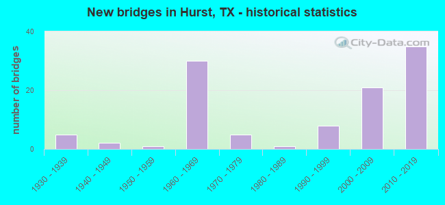
- New bridges - historical statistics
- 51930-1939
- 21940-1949
- 11950-1959
- 301960-1969
- 51970-1979
- 11980-1989
- 81990-1999
- 212000-2009
- 352010-2019
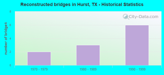
- Reconstructed bridges - Historical Statistics
- 21970-1979
- 31980-1989
- 61990-1999
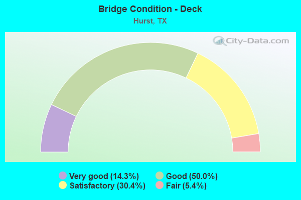
- Bridge Condition - Deck
- 14.3%Very good
- 50.0%Good
- 30.4%Satisfactory
- 5.4%Fair
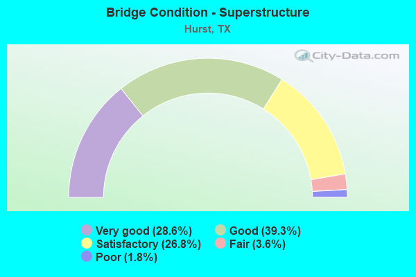
- Bridge Condition - Superstructure
- 28.6%Very good
- 39.3%Good
- 26.8%Satisfactory
- 3.6%Fair
- 1.8%Poor
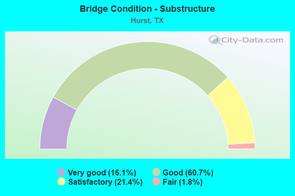
- Bridge Condition - Substructure
- 16.1%Very good
- 60.7%Good
- 21.4%Satisfactory
- 1.8%Fair
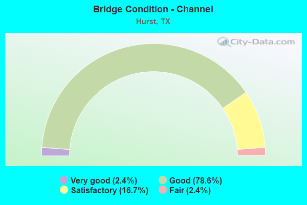
- Bridge Condition - Channel
- 2.4%Very good
- 78.6%Good
- 16.7%Satisfactory
- 2.4%Fair
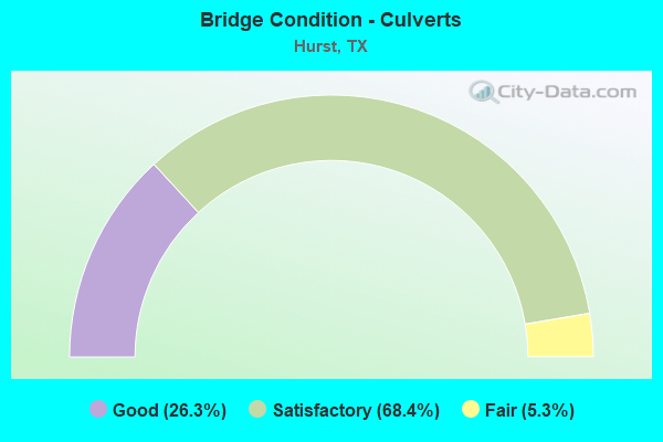
- Bridge Condition - Culverts
- 26.3%Good
- 68.4%Satisfactory
- 5.3%Fair
Find on map >> Show street view
Structure Number: 22200000814516, Location: IH820 ML Viaduct @ SH183 (Lat: 32.832506, Lng: -97.204097), Route carried "under" structure: State highway 183, Year Built: 2014, Structure Length: 0. m, Average Daily Traffic: 77,000 (year 2013), Truck Traffic: 3%, Features Intersected: IH 820 ML VIADUCT, Facility Carried by Structure: IH-820 ML Viaduct
Minimum Vertical Clearance: 5.11m (16.77ft), Kilometerpoint: 0.000, Lanes on structure: 4, Lanes under structure: 11, Material/Design: Steel, Design/Construction: Stringer/Multi-beam, Length of Maximum Span: 55.5m (182.1ft)
Find on map >> Show street view
Structure Number: 22200000814525, Location: IH820 ML VIADUCT @ SH183 (Lat: 32.834219, Lng: -97.198672), Route carried "under" structure: State highway 183, Year Built: 2014, Structure Length: 0. m, Average Daily Traffic: 38,500 (year 2013), Truck Traffic: 1%, Features Intersected: IH 820 EB VIADUCT, Facility Carried by Structure: IH 820 EB VIADUCT
Minimum Vertical Clearance: 5.11m (16.77ft), Kilometerpoint: 0.000, Lanes on structure: 2, Lanes under structure: 4, Material/Design: Prestressed concrete, Design/Construction: Stringer/Multi-beam, Length of Maximum Span: 30.5m (100.1ft)
Find on map >> Show street view
Structure Number: 2220003640141, Location: 700' W OF BEDFORD EULESS (Lat: 32.833075, Lng: -97.202592), Route carried "under" structure: Ramp State highway 121, Year Built: 2001, Structure Length: 0. m, Average Daily Traffic: 3,000 (year 2018), Truck Traffic: 3%, Features Intersected: RAMP M
Minimum Vertical Clearance: 5.16m (16.93ft), Kilometerpoint: 38.327, Lanes on structure: 2, Lanes under structure: 1, Material/Design: Prestressed concrete, Design/Construction: Stringer/Multi-beam, Length of Maximum Span: 36.9m (121.1ft)
Find on map >> Show street view
Structure Number: 22200036401411, Location: 600' W OF BEDFORD EULESS (Lat: 32.833436, Lng: -97.202589), Route carried "under" structure: Ramp State highway 121, Year Built: 2001, Structure Length: 0. m, Average Daily Traffic: 3,000 (year 2018), Truck Traffic: 3%, Features Intersected: RAMP M
Minimum Vertical Clearance: 6.00m (19.69ft), Kilometerpoint: 38.327, Lanes on structure: 2, Lanes under structure: 1, Material/Design: Prestressed concrete, Design/Construction: Stringer/Multi-beam, Length of Maximum Span: 36.3m (119.1ft)
Find on map >> Show street view
Structure Number: 22200036401414, Location: SH 121 AT BEDFORD EULESS (Lat: 32.834208, Lng: -97.200244), Route carried "under" structure: Ramp City street 121, Year Built: 2001, Structure Length: 0. m, Average Daily Traffic: 3,250 (year 2018), Features Intersected: BEDFORD EULESS RD RAMP M
Minimum Vertical Clearance: 6.00m (19.69ft), Kilometerpoint: 38.277, Lanes on structure: 1, Lanes under structure: 9, Material/Design: Steel continuous, Design/Construction: Stringer/Multi-beam, Length of Maximum Span: 53.3m (174.9ft)
Find on map >> Show street view
Structure Number: 22200036401415, Location: IH 820 AT SH 121 (Lat: 32.830683, Lng: -97.203831), Route carried "under" structure: State highway 121, Year Built: 2001, Structure Length: 0. m, Average Daily Traffic: 125,000 (year 2018), Features Intersected: SH 121 ML & RAMPS
Minimum Vertical Clearance: 30+ m (98+ ft), Kilometerpoint: 20.117, Lanes on structure: 1, Lanes under structure: 11, Material/Design: Steel continuous, Design/Construction: Stringer/Multi-beam, Length of Maximum Span: 70.7m (232.0ft)
Find on map >> Show street view
Structure Number: 22200036401663, Location: 0.4 MI. E. OF PRECINCT LN (Lat: 32.840194, Lng: -97.177758), Route carried "under" structure: State highway 121, Year Built: 2013, Structure Length: 0. m, Average Daily Traffic: 160,780 (year 2010), Truck Traffic: 5%, Features Intersected: HURTSVIEW DR, Facility Carried by Structure: HURSTVIEW DRIVE
Minimum Vertical Clearance: 5.11m (16.77ft), Kilometerpoint: 0.000, Lanes on structure: 4, Lanes under structure: 14, Material/Design: Prestressed concrete, Design/Construction: Stringer/Multi-beam, Length of Maximum Span: 35.4m (116.1ft)
Find on map >> Show street view
Structure Number: 22200036401666, Location: 0.48 MI W OF HURSTVIEW (Lat: 32.838681, Lng: -97.186117), Route carried "under" structure: State highway 3029, Year Built: 2013, Structure Length: 0. m, Average Daily Traffic: 18,500 (year 2013), Truck Traffic: 1%, Features Intersected: SH 121/183 EB GP, Facility Carried by Structure: SH 121/183 EB GP
Minimum Vertical Clearance: 5.46m (17.91ft), Kilometerpoint: 0.000, Lanes on structure: 4, Lanes under structure: 9, Material/Design: Prestressed concrete, Design/Construction: Stringer/Multi-beam, Length of Maximum Span: 35.1m (115.2ft)
Find on map >> Show street view
Structure Number: 22200036401667, Location: 0.3 MI W OF FM 3029 (Lat: 32.837861, Lng: -97.192636), Route carried "under" structure: State highway 121, Year Built: 2013, Structure Length: 0. m, Average Daily Traffic: 25,000 (year 2013), Truck Traffic: 5%, Features Intersected: SH 121/183 EB ON RMP
Minimum Vertical Clearance: 5.51m (18.08ft), Kilometerpoint: 0.000, Lanes on structure: 1, Lanes under structure: 5, Material/Design: Prestressed concrete, Design/Construction: Stringer/Multi-beam, Length of Maximum Span: 30.5m (100.1ft)
Find on map >> Show street view
Structure Number: 22200036401668, Location: 0.15 MI W OF FM 3029 (Lat: 32.838989, Lng: -97.190317), Route carried "under" structure: State highway 121, Year Built: 2014, Structure Length: 0. m, Average Daily Traffic: 35,500 (year 2013), Truck Traffic: 5%, Features Intersected: SH 121/183 WBML EXIT
Minimum Vertical Clearance: 5.84m (19.16ft), Kilometerpoint: 0.000, Lanes on structure: 1, Lanes under structure: 4, Material/Design: Prestressed concrete, Design/Construction: Stringer/Multi-beam, Length of Maximum Span: 27.4m (89.9ft)
Find on map >> Show street view
Structure Number: 22200036401669, Location: 0.48 MI W OF HURSTVIEW (Lat: 32.839181, Lng: -97.185939), Route carried "under" structure: State highway 3029, Year Built: 2013, Structure Length: 0. m, Average Daily Traffic: 18,500 (year 2013), Truck Traffic: 1%, Features Intersected: SH 121/183 EBML, Facility Carried by Structure: SH 121/183 EB ML
Minimum Vertical Clearance: 5.28m (17.32ft), Kilometerpoint: 0.000, Lanes on structure: 3, Lanes under structure: 9, Material/Design: Prestressed concrete, Design/Construction: Stringer/Multi-beam, Length of Maximum Span: 34.7m (113.8ft)
Find on map >> Show street view
Structure Number: 2220003640167, Location: 0.48 MI W OF HURSTVIEW (Lat: 32.839358, Lng: -97.186147), Route carried "under" structure: State highway 3029, Year Built: 2014, Structure Length: 0. m, Average Daily Traffic: 18,500 (year 2013), Truck Traffic: 1%, Features Intersected: SH 121/183 WBML, Facility Carried by Structure: SH 121/183 WB ML
Minimum Vertical Clearance: 8.05m (26.41ft), Kilometerpoint: 0.000, Lanes on structure: 2, Lanes under structure: 9, Material/Design: Prestressed concrete, Design/Construction: Stringer/Multi-beam, Length of Maximum Span: 34.7m (113.8ft)
Find on map >> Show street view
Structure Number: 22200036401671, Location: 0.48 MI W OF HURSTVIEW (Lat: 32.839725, Lng: -97.186486), Route carried "under" structure: State highway 3029, Year Built: 2014, Structure Length: 0. m, Average Daily Traffic: 18,500 (year 2013), Truck Traffic: 1%, Features Intersected: SH 121/183 WB GP, Facility Carried by Structure: SH 121/183 WB GP
Minimum Vertical Clearance: 5.39m (17.68ft), Kilometerpoint: 0.000, Lanes on structure: 9, Material/Design: Prestressed concrete, Design/Construction: Stringer/Multi-beam, Length of Maximum Span: 34.7m (113.8ft)
Find on map >> Show street view
Structure Number: 22200036401673, Location: 0.3 MI W OF FM 3029 (Lat: 32.837514, Lng: -97.193219), Route carried "under" structure: Ramp State highway 121, Year Built: 2013, Structure Length: 0. m, Average Daily Traffic: 25,800 (year 2013), Truck Traffic: 5%, Features Intersected: SH 121/183 EB ON RMP
Minimum Vertical Clearance: 5.77m (18.93ft), Kilometerpoint: 0.000, Lanes on structure: 1, Lanes under structure: 1, Material/Design: Prestressed concrete, Design/Construction: Stringer/Multi-beam, Length of Maximum Span: 26.8m (87.9ft)
Find on map >> Show street view
Structure Number: 22200036401674, Location: 0.15 MI W OF FM 3029 (Lat: 32.839275, Lng: -97.189208), Route carried "under" structure: ServiceState highway 121, Year Built: 2014, Structure Length: 0. m, Average Daily Traffic: 1,500 (year 2013), Truck Traffic: 5%, Features Intersected: SH 121 WB GP EXIT
Minimum Vertical Clearance: 5.92m (19.42ft), Kilometerpoint: 0.000, Lanes on structure: 1, Lanes under structure: 1, Material/Design: Prestressed concrete, Design/Construction: Stringer/Multi-beam, Length of Maximum Span: 30.5m (100.1ft)
Find on map >> Show street view
Structure Number: 22200036401675, Location: 1.2 MI E OF FM 3029 (Lat: 32.839314, Lng: -97.167836), Route carried "under" structure: City street , Year Built: 2014, Structure Length: 0. m, Average Daily Traffic: 8,010 (year 2013), Features Intersected: SH 121/183 EB GP, Facility Carried by Structure: SH 121/183 EB GP
Minimum Vertical Clearance: 5.26m (17.26ft), Kilometerpoint: 0.000, Lanes on structure: 4, Lanes under structure: 8, Material/Design: Prestressed concrete, Design/Construction: Stringer/Multi-beam, Length of Maximum Span: 35.7m (117.1ft)
Find on map >> Show street view
Structure Number: 22200036401676, Location: 1.2 MI E OF FM 3029 (Lat: 32.839658, Lng: -97.168008), Route carried "under" structure: City street , Year Built: 2014, Structure Length: 0. m, Average Daily Traffic: 8,010 (year 2013), Features Intersected: Norwood Drive, Facility Carried by Structure: SH 121/183 EB ML
Minimum Vertical Clearance: 5.33m (17.49ft), Kilometerpoint: 0.000, Lanes on structure: 2, Lanes under structure: 6, Material/Design: Prestressed concrete, Design/Construction: Stringer/Multi-beam, Length of Maximum Span: 28.3m (92.8ft)
Find on map >> Show street view
Structure Number: 22200036401677, Location: 1.2 MI E OF FM 3029 (Lat: 32.840053, Lng: -97.167903), Route carried "under" structure: City street , Year Built: 2013, Structure Length: 0. m, Average Daily Traffic: 8,010 (year 2013), Features Intersected: SH 121/183 WB, Facility Carried by Structure: SH 121/183 WB ML
Minimum Vertical Clearance: 5.41m (17.75ft), Lanes on structure: 2, Lanes under structure: 8, Material/Design: Prestressed concrete, Design/Construction: Stringer/Multi-beam, Length of Maximum Span: 28.3m (92.8ft)
Find on map >> Show street view
Structure Number: 22200036401678, Location: 1.2 MI E OF FM 3029 (Lat: 32.837339, Lng: -97.099908), Route carried "under" structure: City street , Year Built: 2013, Structure Length: 0. m, Average Daily Traffic: 8,010 (year 2013), Features Intersected: SH 121/183 WB GP, Facility Carried by Structure: SH-121/183 WB GP
Minimum Vertical Clearance: 5.39m (17.68ft), Kilometerpoint: 0.000, Lanes on structure: 4, Lanes under structure: 6, Material/Design: Prestressed concrete, Design/Construction: Stringer/Multi-beam, Length of Maximum Span: 35.4m (116.1ft)