Bridge Statistics for Iola, Kansas (KS)
Condition, Traffic, Stress, Structural Evaluation, Project Costs
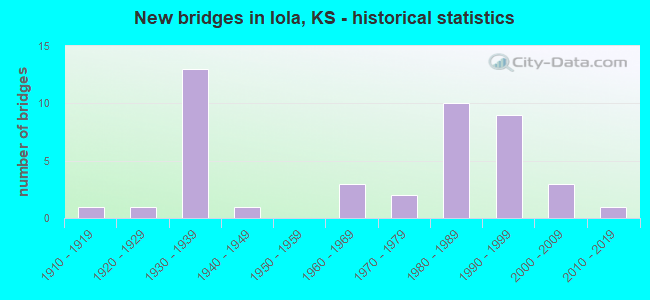
- New bridges - historical statistics
- 11910-1919
- 11920-1929
- 131930-1939
- 11940-1949
- 31960-1969
- 21970-1979
- 101980-1989
- 91990-1999
- 32000-2009
- 12010-2019

- Reconstructed bridges - Historical Statistics
- 11990-1999
- 12000-2009
- 12010-2019


- Bridge Condition - Deck
- 10.0%Very good
- 36.7%Good
- 20.0%Satisfactory
- 26.7%Fair
- 6.7%Serious

- Bridge Condition - Superstructure
- 36.7%Very good
- 13.3%Good
- 20.0%Satisfactory
- 13.3%Fair
- 13.3%Poor
- 3.3%Serious

- Bridge Condition - Substructure
- 30.0%Very good
- 23.3%Good
- 16.7%Satisfactory
- 23.3%Fair
- 3.3%Poor
- 3.3%Serious

- Bridge Condition - Channel
- 19.4%Very good
- 33.3%Good
- 16.7%Satisfactory
- 27.8%Fair
- 2.8%Poor

- Bridge Condition - Culverts
- 10.0%Very good
- 60.0%Good
- 30.0%Satisfactory
Find on map >> Show street view
Structure Number: 1007, Location: W. EDGE OF HUMBOLDT (Lat: 37.811172, Lng: -95.447811), Route carried "on" structure: County highway 2, Year Built: 1932, Status: Posted for load, Structure Length: 7.56m (24.80ft), Average Daily Traffic: 1,098 (year 2006), Truck Traffic: 11%, Average Future Daily Traffic: 1,136 (year 2040), Design Load: H 15, Features Intersected: NEOSHO RIVER
Minimum Vertical Clearance: 8.83m (28.97ft), Kilometerpoint: 4.989, Lanes on structure: 2, Owner: County Highway Agency, Approaching Roadway Width: 7.3m (24.0ft), Material/Design: Concrete, Design/Construction: Arch - Thru, Number Of Spans In Main Unit: 2, Length of Maximum Span: 36.6m (120.1ft), Curb or Sidewalk Widths: Left: 0.9m (3.0ft), Right: 0.9m (3.0ft), Curb-To-Curb Width: 6.1m (20.0ft), Out-to-Out Width: 7.9m (25.9ft)
Condition: Deck: Fair, Superstructure: Fair, Substructure: Satisfactory, Channel: Poor, Operating Rating: 34.7 metric tons, Method Used To Determine Operating Rating: Load Factor (LF), Inventory Rating: 20.6 metric tons, Method Used To Determine Inventory Rating: Load Factor (LF), Structural Evaluation: Somewhat better than minimum adequacy, Deck Geometry: High priority of replacement, Waterway Adequacy: Equal to present minimum criteria, Approach Roadway Alignment: Better than present minimum criteria, Length Of Structure Improvement: 10.06m (33.01ft), Designated Inspection Frequency: Every 24 months, Underwater Inspection Frequency: Every 60 months, Inspection Date: May 2020, Underwater Inspection Date: November 2018, Bridge Improvement Cost: $290,000, Roadway Improvement Cost: $29,000, Total Project Cost: $435,000, Deck Structure Type: Concrete Cast-file-Place
Find on map >> Show street view
Structure Number: 1014, Location: 1.4W OF CARLYLE (Lat: 37.995000, Lng: -95.415278), Route carried "on" structure: County highway 4, Year Built: 1936, Status: Posted for load, Structure Length: 1.22m (4.00ft), Average Daily Traffic: 178 (year 2006), Truck Traffic: 10%, Average Future Daily Traffic: 206 (year 2040), Design Load: H 15, Features Intersected: BRANCH OF DEER CREEK
Minimum Vertical Clearance: 30.47m (99.97ft), Kilometerpoint: 10.673, Lanes on structure: 2, Owner: County Highway Agency, Approaching Roadway Width: 8.5m (27.9ft), Material/Design: Concrete, Design/Construction: Culvert, Number Of Spans In Main Unit: 4, Length of Maximum Span: 2.7m (8.9ft), Curb or Sidewalk Widths: Left: 0.3m (1.0ft), Right: 0.3m (1.0ft), Curb-To-Curb Width: 9.8m (32.2ft), Out-to-Out Width: 10.5m (34.4ft)
Condition: Channel: Satisfactory, Culverts: Satisfactory, Operating Rating: 36.9 metric tons, Method Used To Determine Operating Rating: Load Factor (LF), Inventory Rating: 21.6 metric tons, Method Used To Determine Inventory Rating: Load Factor (LF), Structural Evaluation: Equal to present minimum criteria, Deck Geometry: Better than present minimum criteria, Waterway Adequacy: Better than present minimum criteria, Approach Roadway Alignment: Equal to present desirable criteria, Length Of Structure Improvement: 1.22m (4.00ft), Designated Inspection Frequency: Every 24 months, Inspection Date: Febuary 2020, Bridge Improvement Cost: $150,000, Roadway Improvement Cost: $25,000, Total Project Cost: $225,000
Find on map >> Show street view
Structure Number: 1015, Location: 0.2E OF CARLYLE (Lat: 37.994942, Lng: -95.386319), Route carried "on" structure: County highway 4, Year Built: 1930, Status: Posted for load, Structure Length: 1.00m (3.28ft), Average Daily Traffic: 178 (year 2006), Truck Traffic: 10%, Average Future Daily Traffic: 180 (year 2040), Features Intersected: BRANCH OF DEER CREEK
Minimum Vertical Clearance: 30.47m (99.97ft), Kilometerpoint: 13.361, Lanes on structure: 2, Owner: County Highway Agency, Approaching Roadway Width: 6.1m (20.0ft), Material/Design: Concrete, Design/Construction: Stringer/Multi-beam, Number Of Spans In Main Unit: 1, Length of Maximum Span: 9.5m (31.2ft), Curb or Sidewalk Widths: Left: 0.5m (1.6ft), Right: 0.5m (1.6ft), Curb-To-Curb Width: 6.2m (20.3ft), Out-to-Out Width: 7.2m (23.6ft)
Condition: Deck: Satisfactory, Superstructure: Satisfactory, Substructure: Satisfactory, Channel: Fair, Operating Rating: 27.0 metric tons, Method Used To Determine Operating Rating: Load Testing, Inventory Rating: 19.8 metric tons, Method Used To Determine Inventory Rating: Load Testing, Structural Evaluation: Somewhat better than minimum adequacy, Deck Geometry: Meets minimum limits, Waterway Adequacy: Somewhat better than minimum adequacy, Approach Roadway Alignment: Equal to present minimum criteria, Bridge Posting: Required (Relationship of Operating Rating to Maximum Legal Load: 0.1 - 9.9% below), Length Of Structure Improvement: 1.16m (3.81ft), Designated Inspection Frequency: Every 24 months, Inspection Date: Febuary 2020, Other Special Inspection Date: August 2021, Bridge Improvement Cost: $33,000, Roadway Improvement Cost: $3,000, Total Project Cost: $50,000, Deck Structure Type: Concrete Cast-file-Place, Wearing Surface/Protective System: Wearing Surface: Monolithic Concrete
Find on map >> Show street view
Structure Number: 1053, Location: 1.5N 2.0W OF IOLA (Lat: 37.965772, Lng: -95.454261), Route carried "on" structure: County highway 1154, Year Built: 1930, Status: Posted for load, Structure Length: 0.64m (2.10ft), Average Daily Traffic: 130 (year 2006), Truck Traffic: 10%, Average Future Daily Traffic: 159 (year 2041), Features Intersected: TRIB. TO NEOSHO RIVER, Facility Carried by Structure: Rhode Island Rd
Minimum Vertical Clearance: 30.47m (99.97ft), Kilometerpoint: 6.439, Lanes on structure: 2, Owner: County Highway Agency, Approaching Roadway Width: 6.4m (21.0ft), Material/Design: Concrete continuous, Design/Construction: Slab, Number Of Spans In Main Unit: 2, Length of Maximum Span: 3.0m (9.8ft), Curb-To-Curb Width: 5.2m (17.1ft), Out-to-Out Width: 5.5m (18.0ft)
Condition: Deck: Satisfactory, Superstructure: Satisfactory, Substructure: Fair, Channel: Fair, Operating Rating: 21.6 metric tons, Method Used To Determine Operating Rating: Load Testing, Inventory Rating: 16.2 metric tons, Method Used To Determine Inventory Rating: Load Testing, Structural Evaluation: Somewhat better than minimum adequacy, Deck Geometry: High priority of replacement, Waterway Adequacy: Somewhat better than minimum adequacy, Approach Roadway Alignment: Somewhat better than minimum adequacy, Length Of Structure Improvement: 0.91m (2.99ft), Designated Inspection Frequency: Every 12 months, Inspection Date: Febuary 2021, Other Special Inspection Date: August 2021, Bridge Improvement Cost: $65,000, Roadway Improvement Cost: $15,000, Total Project Cost: $95,000, Deck Structure Type: Concrete Cast-file-Place, Wearing Surface/Protective System: Wearing Surface: Gravel
Find on map >> Show street view
Structure Number: 11023005866, Location: 3.0W OF IOLA (Lat: 37.912742, Lng: -95.464294), Route carried "on" structure: County highway , Year Built: 1980, Status: Open, Structure Length: 1.40m (4.59ft), Average Daily Traffic: 40 (year 2006), Average Future Daily Traffic: 40 (year 2040), Features Intersected: STREAM, Facility Carried by Structure: 800 St. 4.0-I.6
Minimum Vertical Clearance: 30.47m (99.97ft), Kilometerpoint: 0.000, Lanes on structure: 2, Owner: County Highway Agency, Approaching Roadway Width: 8.5m (27.9ft), Material/Design: Steel, Design/Construction: Culvert, Number Of Spans In Main Unit: 4, Length of Maximum Span: 1.8m (5.9ft), Curb-To-Curb Width: 7.6m (24.9ft), Out-to-Out Width: 7.6m (24.9ft)
Condition: Channel: Fair, Culverts: Satisfactory, Operating Rating: 22.9 metric tons, Method Used To Determine Operating Rating: Load Factor (LF), Inventory Rating: 13.7 metric tons, Method Used To Determine Inventory Rating: Load Factor (LF), Structural Evaluation: Meets minimum limits, Deck Geometry: Equal to present minimum criteria, Waterway Adequacy: High priority of corrective action, Approach Roadway Alignment: Better than present minimum criteria, Length Of Structure Improvement: 1.52m (4.99ft), Designated Inspection Frequency: Every 24 months, Inspection Date: March 2020, Bridge Improvement Cost: $61,000, Roadway Improvement Cost: $6,000, Total Project Cost: $92,000
Find on map >> Show street view
Structure Number: 11025005768, Location: 0.8S 3.0W OF CARLYLE (Lat: 37.983678, Lng: -95.445797), Route carried "on" structure: County highway , Year Built: 1930, Status: Open, Structure Length: 0.79m (2.59ft), Average Daily Traffic: 40 (year 2006), Average Future Daily Traffic: 40 (year 2040), Features Intersected: STREAM, Facility Carried by Structure: 1000th Rd 5.0-D.8
Minimum Vertical Clearance: 30.47m (99.97ft), Kilometerpoint: 0.000, Lanes on structure: 2, Owner: County Highway Agency, Approaching Roadway Width: 7.5m (24.6ft), Material/Design: Concrete, Design/Construction: Slab, Number Of Spans In Main Unit: 3, Length of Maximum Span: 2.1m (6.9ft), Curb-To-Curb Width: 7.3m (24.0ft), Out-to-Out Width: 8.2m (26.9ft)
Condition: Deck: Fair, Superstructure: Fair, Substructure: Fair, Channel: Satisfactory, Operating Rating: 27.0 metric tons, Method Used To Determine Operating Rating: Load Testing, Inventory Rating: 19.8 metric tons, Method Used To Determine Inventory Rating: Load Testing, Structural Evaluation: Somewhat better than minimum adequacy, Deck Geometry: Equal to present minimum criteria, Waterway Adequacy: Somewhat better than minimum adequacy, Approach Roadway Alignment: Better than present minimum criteria, Length Of Structure Improvement: 0.79m (2.59ft), Designated Inspection Frequency: Every 24 months, Inspection Date: Febuary 2020, Bridge Improvement Cost: $46,000, Roadway Improvement Cost: $17,000, Total Project Cost: $69,000, Deck Structure Type: Concrete Cast-file-Place, Wearing Surface/Protective System: Wearing Surface: Gravel
Find on map >> Show street view
Structure Number: 1102590592, Location: 1.0W 3.0S OF IOLA (Lat: 37.878314, Lng: -95.429078), Route carried "on" structure: County highway , Year Built: 1940, Status: Open, Structure Length: 0.70m (2.30ft), Average Daily Traffic: 40 (year 2006), Average Future Daily Traffic: 40 (year 2040), Features Intersected: STREAM, Facility Carried by Structure: LOCAL RD 5.9-L.0
Minimum Vertical Clearance: 30.47m (99.97ft), Kilometerpoint: 0.000, Lanes on structure: 2, Owner: County Highway Agency, Approaching Roadway Width: 6.7m (22.0ft), Material/Design: Concrete, Design/Construction: Slab, Number Of Spans In Main Unit: 1, Length of Maximum Span: 6.4m (21.0ft), Curb-To-Curb Width: 6.1m (20.0ft), Out-to-Out Width: 6.7m (22.0ft)
Condition: Deck: Satisfactory, Superstructure: Satisfactory, Substructure: Good, Channel: Satisfactory, Operating Rating: 27.0 metric tons, Method Used To Determine Operating Rating: Load Testing, Inventory Rating: 19.8 metric tons, Method Used To Determine Inventory Rating: Load Testing, Structural Evaluation: Somewhat better than minimum adequacy, Deck Geometry: Somewhat better than minimum adequacy, Waterway Adequacy: Equal to present minimum criteria, Approach Roadway Alignment: Better than present minimum criteria, Designated Inspection Frequency: Every 24 months, Inspection Date: March 2020, Deck Structure Type: Concrete Cast-file-Place, Wearing Surface/Protective System: Wearing Surface: Bituminous
Find on map >> Show street view
Structure Number: 1102960578, Location: 1.0S 0.5W OF CARLYLE (Lat: 37.980286, Lng: -95.398067), Route carried "on" structure: County highway , Year Built: 1930, Status: Open, Structure Length: 1.07m (3.51ft), Average Daily Traffic: 30 (year 2006), Average Future Daily Traffic: 30 (year 2040), Features Intersected: DEER CREEK, Facility Carried by Structure: LOCAL RD. 7.6-E.0
Minimum Vertical Clearance: 30.47m (99.97ft), Kilometerpoint: 0.000, Lanes on structure: 2, Owner: County Highway Agency, Approaching Roadway Width: 6.7m (22.0ft), Material/Design: Concrete, Design/Construction: Slab, Number Of Spans In Main Unit: 3, Length of Maximum Span: 2.7m (8.9ft), Curb-To-Curb Width: 7.6m (24.9ft), Out-to-Out Width: 7.9m (25.9ft)
Condition: Deck: Fair, Superstructure: Fair, Substructure: Fair, Channel: Fair, Operating Rating: 27.0 metric tons, Method Used To Determine Operating Rating: Load Testing, Inventory Rating: 19.8 metric tons, Method Used To Determine Inventory Rating: Load Testing, Structural Evaluation: Somewhat better than minimum adequacy, Deck Geometry: Equal to present minimum criteria, Waterway Adequacy: High priority of corrective action, Approach Roadway Alignment: Meets minimum limits, Length Of Structure Improvement: 23.00m (75.46ft), Designated Inspection Frequency: Every 24 months, Inspection Date: Febuary 2020, Bridge Improvement Cost: $400,000, Roadway Improvement Cost: $50,000, Total Project Cost: $600,000, Deck Structure Type: Concrete Cast-file-Place
Find on map >> Show street view
Structure Number: 1103100578, Location: 1.0S OF CARLYLE (Lat: 37.980294, Lng: -95.390575), Route carried "on" structure: County highway , Year Built: 1930, Status: Open, Structure Length: 0.88m (2.89ft), Average Daily Traffic: 30 (year 2006), Average Future Daily Traffic: 30 (year 2040), Features Intersected: DEER CREEK,LWC, Facility Carried by Structure: 8.0-E.0 1600 St
Minimum Vertical Clearance: 30.47m (99.97ft), Kilometerpoint: 0.000, Lanes on structure: 2, Owner: County Highway Agency, Approaching Roadway Width: 6.4m (21.0ft), Material/Design: Concrete, Design/Construction: Slab, Number Of Spans In Main Unit: 3, Length of Maximum Span: 2.7m (8.9ft), Curb-To-Curb Width: 7.3m (24.0ft), Out-to-Out Width: 7.3m (24.0ft)
Condition: Deck: Fair, Superstructure: Fair, Substructure: Fair, Channel: Fair, Operating Rating: 27.0 metric tons, Method Used To Determine Operating Rating: Load Testing, Inventory Rating: 19.8 metric tons, Method Used To Determine Inventory Rating: Load Testing, Structural Evaluation: Somewhat better than minimum adequacy, Deck Geometry: Equal to present minimum criteria, Waterway Adequacy: High priority of replacement, Approach Roadway Alignment: High priority of corrective action, Length Of Structure Improvement: 6.71m (22.01ft), Designated Inspection Frequency: Every 24 months, Inspection Date: Febuary 2020, Bridge Improvement Cost: $375,000, Roadway Improvement Cost: $50,000, Total Project Cost: $550,000, Deck Structure Type: Concrete Cast-file-Place
Find on map >> Show street view
Structure Number: 11031205863, Location: S.E. EDGE OF IOLA (Lat: 37.914181, Lng: -95.387994), Route carried "on" structure: County highway , Year Built: 1977, Status: Open, Structure Length: 4.63m (15.19ft), Average Daily Traffic: 120 (year 2006), Truck Traffic: 11%, Average Future Daily Traffic: 120 (year 2040), Design Load: H 20, Features Intersected: ROCK CREEK, Facility Carried by Structure: Nevada Rd 8.2-I.3
Minimum Vertical Clearance: 30.47m (99.97ft), Kilometerpoint: 0.000, Lanes on structure: 2, Owner: County Highway Agency, Approaching Roadway Width: 9.1m (29.9ft), Material/Design: Prestressed concrete, Design/Construction: Tee Beam, Number Of Spans In Main Unit: 3, Length of Maximum Span: 15.2m (49.9ft), Curb-To-Curb Width: 7.9m (25.9ft), Out-to-Out Width: 8.5m (27.9ft)
Condition: Deck: Satisfactory, Superstructure: Good, Substructure: Very good, Channel: Good, Operating Rating: 62.1 metric tons, Method Used To Determine Operating Rating: Load Factor (LF), Inventory Rating: 33.1 metric tons, Method Used To Determine Inventory Rating: Load Factor (LF), Structural Evaluation: Better than present minimum criteria, Deck Geometry: Somewhat better than minimum adequacy, Waterway Adequacy: Better than present minimum criteria, Approach Roadway Alignment: Equal to present desirable criteria, Designated Inspection Frequency: Every 24 months, Inspection Date: March 2020, Deck Structure Type: Concrete Cast-file-Place, Wearing Surface/Protective System: Wearing Surface: Bituminous
Find on map >> Show street view
Structure Number: 1103130588, Location: 1.0S.E. OF IOLA (Lat: 37.907608, Lng: -95.385094), Route carried "on" structure: County highway , Year Built: 2003, Status: Open, Structure Length: 5.09m (16.70ft), Average Daily Traffic: 300 (year 2006), Truck Traffic: 15%, Average Future Daily Traffic: 355 (year 2040), Design Load: HS 20, Features Intersected: ELM CREEK, Facility Carried by Structure: LOCAL RD 8.3-J.0
Minimum Vertical Clearance: 30.47m (99.97ft), Kilometerpoint: 0.000, Lanes on structure: 2, Owner: County Highway Agency, Approaching Roadway Width: 8.6m (28.2ft), Skew: 3 degrees, Material/Design: Concrete continuous, Design/Construction: Slab, Number Of Spans In Main Unit: 3, Length of Maximum Span: 20.0m (65.6ft), Curb-To-Curb Width: 8.6m (28.2ft), Out-to-Out Width: 9.2m (30.2ft)
Condition: Deck: Very good, Superstructure: Very good, Substructure: Very good, Channel: Very good, Operating Rating: 61.7 metric tons, Method Used To Determine Operating Rating: Load Factor (LF), Inventory Rating: 37.2 metric tons, Method Used To Determine Inventory Rating: Load Factor (LF), Structural Evaluation: Equal to present desirable criteria, Deck Geometry: Equal to present minimum criteria, Waterway Adequacy: Better than present minimum criteria, Approach Roadway Alignment: Better than present minimum criteria, Length Of Structure Improvement: 2.44m (8.01ft), Designated Inspection Frequency: Every 24 months, Inspection Date: March 2020, Bridge Improvement Cost: $106,000, Roadway Improvement Cost: $11,000, Total Project Cost: $159,000, Deck Structure Type: Concrete Cast-file-Place, Wearing Surface/Protective System: Wearing Surface: Monolithic Concrete, Deck Protection: Epoxy Coated Reinforcing
Find on map >> Show street view
Structure Number: 11033005887, Location: 1.7S 2.0E OF IOLA (Lat: 37.896589, Lng: -95.372506), Route carried "on" structure: County highway , Year Built: 1979, Year Reconstructed: 2005, Status: Open, Structure Length: 0.85m (2.79ft), Average Daily Traffic: 20 (year 2006), Average Future Daily Traffic: 25 (year 2040), Features Intersected: ELM CREEK, Facility Carried by Structure: LOCAL RD. 9.0-J.7
Minimum Vertical Clearance: 30.47m (99.97ft), Kilometerpoint: 0.000, Lanes on structure: 2, Owner: County Highway Agency, Approaching Roadway Width: 6.0m (19.7ft), Material/Design: Steel, Design/Construction: Culvert, Number Of Spans In Main Unit: 5, Length of Maximum Span: 1.2m (3.9ft), Curb-To-Curb Width: 8.1m (26.6ft), Out-to-Out Width: 8.1m (26.6ft)
Condition: Channel: Fair, Culverts: Good, Operating Rating: 22.7 metric tons, Method Used To Determine Operating Rating: Load Factor (LF), Inventory Rating: 13.6 metric tons, Method Used To Determine Inventory Rating: Load Factor (LF), Structural Evaluation: Meets minimum limits, Deck Geometry: Equal to present minimum criteria, Waterway Adequacy: High priority of corrective action, Approach Roadway Alignment: Equal to present minimum criteria, Length Of Structure Improvement: 3.66m (12.01ft), Designated Inspection Frequency: Every 24 months, Inspection Date: March 2020, Bridge Improvement Cost: $200,000, Roadway Improvement Cost: $35,000, Total Project Cost: $300,000
Find on map >> Show street view
Structure Number: 1103300596, Location: 3.5E 2.5N OF HUMBOLDT (Lat: 37.849369, Lng: -95.371783), Route carried "on" structure: County highway 110, Year Built: 1930, Status: Open, Structure Length: 1.16m (3.81ft), Average Daily Traffic: 60 (year 2006), Average Future Daily Traffic: 60 (year 2040), Features Intersected: STREAM, Facility Carried by Structure: MINOR COL 9.0-N.0
Minimum Vertical Clearance: 30.47m (99.97ft), Kilometerpoint: 0.000, Lanes on structure: 2, Owner: County Highway Agency, Approaching Roadway Width: 7.3m (24.0ft), Material/Design: Concrete continuous, Design/Construction: Slab, Number Of Spans In Main Unit: 4, Length of Maximum Span: 2.7m (8.9ft), Curb-To-Curb Width: 7.3m (24.0ft), Out-to-Out Width: 7.9m (25.9ft)
Condition: Deck: Satisfactory, Superstructure: Satisfactory, Substructure: Fair, Channel: Satisfactory, Operating Rating: 27.0 metric tons, Method Used To Determine Operating Rating: Load Testing, Inventory Rating: 19.8 metric tons, Method Used To Determine Inventory Rating: Load Testing, Structural Evaluation: Somewhat better than minimum adequacy, Deck Geometry: Equal to present minimum criteria, Waterway Adequacy: Somewhat better than minimum adequacy, Approach Roadway Alignment: Better than present minimum criteria, Length Of Structure Improvement: 1.19m (3.90ft), Designated Inspection Frequency: Every 24 months, Inspection Date: March 2020, Bridge Improvement Cost: $69,000, Roadway Improvement Cost: $15,000, Total Project Cost: $103,000, Deck Structure Type: Concrete Cast-file-Place
Find on map >> Show street view
Structure Number: 1103500578, Location: 1.0S 2.0E OF CARLYLE (Lat: 37.979444, Lng: -95.353775), Route carried "on" structure: County highway , Year Built: 1930, Status: Posted for load, Structure Length: 0.67m (2.20ft), Average Daily Traffic: 30 (year 2006), Average Future Daily Traffic: 35 (year 2041), Features Intersected: STREAM, Facility Carried by Structure: 10.0-E.0 2000 ST
Minimum Vertical Clearance: 30.47m (99.97ft), Kilometerpoint: 0.000, Lanes on structure: 2, Owner: County Highway Agency, Approaching Roadway Width: 7.3m (24.0ft), Skew: 4 degrees, Material/Design: Concrete, Design/Construction: Slab, Number Of Spans In Main Unit: 2, Length of Maximum Span: 2.4m (7.9ft), Curb-To-Curb Width: 9.1m (29.9ft), Out-to-Out Width: 9.8m (32.2ft)
Condition: Deck: Serious, Superstructure: Poor, Substructure: Serious, Channel: Fair, Operating Rating: 24.5 metric tons, Method Used To Determine Operating Rating: Load Testing, Inventory Rating: 19.8 metric tons, Method Used To Determine Inventory Rating: Load Testing, Structural Evaluation: High priority of corrective action, Deck Geometry: Better than present minimum criteria, Waterway Adequacy: Somewhat better than minimum adequacy, Approach Roadway Alignment: Equal to present minimum criteria, Length Of Structure Improvement: 0.91m (2.99ft), Designated Inspection Frequency: Every 12 months, Inspection Date: Febuary 2021, Bridge Improvement Cost: $75,000, Roadway Improvement Cost: $15,000, Total Project Cost: $125,000, Deck Structure Type: Concrete Cast-file-Place, Wearing Surface/Protective System: Wearing Surface: Gravel
Find on map >> Show street view
Structure Number: 413700012101002, Location: 02 WASH. AT BENTON (Lat: 37.925833, Lng: -95.405544), Route carried "on" structure: Business City street 2101, Year Built: 1988, Status: Posted for load, Structure Length: 1.49m (4.89ft), Average Daily Traffic: 5,000 (year 2003), Truck Traffic: 2%, Average Future Daily Traffic: 5,000 (year 2042), Design Load: HS 20, Features Intersected: COON CREEK, Facility Carried by Structure: N. WASHINGTON AVE.
Minimum Vertical Clearance: 30.47m (99.97ft), Kilometerpoint: 0.000, Lanes on structure: 2, Owner: City or Municipal Highway Agency, Approaching Roadway Width: 15.5m (50.9ft), Material/Design: Concrete continuous, Design/Construction: Slab, Number Of Spans In Main Unit: 2, Length of Maximum Span: 7.3m (24.0ft), Curb or Sidewalk Widths: Left: 2.0m (6.6ft), Right: 2.0m (6.6ft), Curb-To-Curb Width: 15.2m (49.9ft), Out-to-Out Width: 19.8m (65.0ft)
Condition: Deck: Satisfactory, Superstructure: Satisfactory, Substructure: Satisfactory, Channel: Good, Operating Rating: 27.8 metric tons, Method Used To Determine Operating Rating: Load Factor (LF), Inventory Rating: 16.3 metric tons, Method Used To Determine Inventory Rating: Load Factor (LF), Structural Evaluation: Meets minimum limits, Deck Geometry: Superior to present desirable criteria, Waterway Adequacy: Equal to present minimum criteria, Approach Roadway Alignment: Equal to present desirable criteria, Bridge Posting: Required (Relationship of Operating Rating to Maximum Legal Load: 0.1 - 9.9% below), Designated Inspection Frequency: Every 24 months, Inspection Date: January 2022, Deck Structure Type: Concrete Cast-file-Place, Wearing Surface/Protective System: Deck Protection: Epoxy Coated Reinforcing
Find on map >> Show street view
Structure Number: 413700012103003, Location: 03 N. JEFF. @ DOUGLAS (Lat: 37.926681, Lng: -95.403367), Route carried "on" structure: City street 2103, Year Built: 2010, Status: Open, Structure Length: 0.75m (2.46ft), Average Daily Traffic: 1,500 (year 2003), Truck Traffic: 1%, Average Future Daily Traffic: 1,500 (year 2042), Design Load: HS 20, Features Intersected: COON CREEK
Minimum Vertical Clearance: 30.47m (99.97ft), Kilometerpoint: 0.000, Lanes on structure: 2, Owner: City or Municipal Highway Agency, Approaching Roadway Width: 31.2m (102.4ft), Material/Design: Concrete, Design/Construction: Culvert, Number Of Spans In Main Unit: 2, Length of Maximum Span: 3.7m (12.1ft), Curb-To-Curb Width: 31.2m (102.4ft), Out-to-Out Width: 31.7m (104.0ft)
Condition: Channel: Good, Culverts: Good, Operating Rating: 79.7 metric tons, Method Used To Determine Operating Rating: Load Factor (LF), Inventory Rating: 47.2 metric tons, Method Used To Determine Inventory Rating: Load Factor (LF), Structural Evaluation: Better than present minimum criteria, Deck Geometry: Superior to present desirable criteria, Waterway Adequacy: Better than present minimum criteria, Approach Roadway Alignment: Equal to present desirable criteria, Designated Inspection Frequency: Every 24 months, Inspection Date: January 2022, Wearing Surface/Protective System: Wearing Surface: Bituminous
Find on map >> Show street view
Structure Number: 413700012105004, Location: 04 COTTONWOOD/ CARPENTER (Lat: 37.929794, Lng: -95.399856), Route carried "on" structure: Business City street 2105, Year Built: 1962, Status: Open, Structure Length: 0.87m (2.85ft), Average Daily Traffic: 1,700 (year 2003), Truck Traffic: 1%, Average Future Daily Traffic: 2,000 (year 2042), Design Load: H 20, Features Intersected: COON CREEK, Facility Carried by Structure: N. COTTONWOOD ST.
Minimum Vertical Clearance: 30.47m (99.97ft), Kilometerpoint: 0.000, Lanes on structure: 2, Owner: City or Municipal Highway Agency, Approaching Roadway Width: 8.1m (26.6ft), Skew: 3 degrees, Material/Design: Concrete, Design/Construction: Culvert, Number Of Spans In Main Unit: 2, Length of Maximum Span: 4.3m (14.1ft), Curb or Sidewalk Widths: Left: 2.4m (7.9ft), Right: 2.4m (7.9ft), Curb-To-Curb Width: 7.9m (25.9ft), Out-to-Out Width: 13.1m (43.0ft)
Condition: Channel: Fair, Culverts: Good, Operating Rating: 34.2 metric tons, Method Used To Determine Operating Rating: Load Factor (LF), Inventory Rating: 24.5 metric tons, Method Used To Determine Inventory Rating: Load Factor (LF), Structural Evaluation: Equal to present minimum criteria, Deck Geometry: Meets minimum limits, Waterway Adequacy: Equal to present minimum criteria, Approach Roadway Alignment: Equal to present desirable criteria, Length Of Structure Improvement: 0.91m (2.99ft), Designated Inspection Frequency: Every 24 months, Inspection Date: January 2022, Bridge Improvement Cost: $51,000, Roadway Improvement Cost: $6,000, Total Project Cost: $80,000
Find on map >> Show street view
Structure Number: 513700010000001, Location: 21 CAMERON WEST STATE ST (Lat: 37.923889, Lng: -95.409897), Route carried "on" structure: City street , Year Built: 1930, Status: Open, Structure Length: 0.94m (3.08ft), Average Daily Traffic: 5 (year 2003), Average Future Daily Traffic: 5 (year 2042), Features Intersected: COON CREEK, Facility Carried by Structure: CAMERON STREET
Minimum Vertical Clearance: 30.47m (99.97ft), Kilometerpoint: 0.000, Lanes on structure: 2, Owner: City or Municipal Highway Agency, Approaching Roadway Width: 5.7m (18.7ft), Material/Design: Concrete, Design/Construction: Slab, Number Of Spans In Main Unit: 2, Length of Maximum Span: 4.3m (14.1ft), Curb or Sidewalk Widths: Left: 0.3m (1.0ft), Right: 0.3m (1.0ft), Curb-To-Curb Width: 5.2m (17.1ft), Out-to-Out Width: 5.9m (19.4ft)
Condition: Deck: Fair, Superstructure: Satisfactory, Substructure: Satisfactory, Channel: Satisfactory, Operating Rating: 27.2 metric tons, Method Used To Determine Operating Rating: No rating analysis performed, Inventory Rating: 16.3 metric tons, Method Used To Determine Inventory Rating: No rating analysis performed, Structural Evaluation: Somewhat better than minimum adequacy, Deck Geometry: High priority of corrective action, Waterway Adequacy: Equal to present minimum criteria, Approach Roadway Alignment: Equal to present minimum criteria, Length Of Structure Improvement: 1.52m (4.99ft), Designated Inspection Frequency: Every 24 months, Inspection Date: January 2022, Bridge Improvement Cost: $85,000, Roadway Improvement Cost: $10,000, Total Project Cost: $130,000, Deck Structure Type: Concrete Cast-file-Place, Wearing Surface/Protective System: Wearing Surface: Bituminous
Find on map >> Show street view
Structure Number: 513700010000002, Location: 22 CHESTNUT & BENTON ST. (Lat: 37.925664, Lng: -95.407869), Route carried "on" structure: City street , Year Built: 1927, Status: Open, Structure Length: 1.13m (3.71ft), Average Daily Traffic: 200 (year 2003), Truck Traffic: 1%, Average Future Daily Traffic: 200 (year 2042), Design Load: Railroad, Features Intersected: COON CREEK, Facility Carried by Structure: CHESTNUT STREET
Minimum Vertical Clearance: 30.47m (99.97ft), Kilometerpoint: 0.000, Lanes on structure: 2, Owner: City or Municipal Highway Agency, Approaching Roadway Width: 7.5m (24.6ft), Skew: 4 degrees, Material/Design: Concrete, Design/Construction: Culvert, Number Of Spans In Main Unit: 3, Length of Maximum Span: 3.4m (11.2ft), Curb or Sidewalk Widths: Left: 1.5m (4.9ft), Right: 1.5m (4.9ft), Curb-To-Curb Width: 8.8m (28.9ft), Out-to-Out Width: 17.5m (57.4ft)
Condition: Channel: Good, Culverts: Satisfactory, Operating Rating: 20.9 metric tons, Method Used To Determine Operating Rating: Load Testing, Inventory Rating: 15.4 metric tons, Method Used To Determine Inventory Rating: Load Testing, Structural Evaluation: Meets minimum limits, Deck Geometry: Equal to present minimum criteria, Waterway Adequacy: Somewhat better than minimum adequacy, Approach Roadway Alignment: Equal to present desirable criteria, Length Of Structure Improvement: 1.22m (4.00ft), Designated Inspection Frequency: Every 24 months, Inspection Date: January 2022, Bridge Improvement Cost: $75,000, Roadway Improvement Cost: $10,000, Total Project Cost: $120,000
Find on map >> Show street view
Structure Number: 513700010000003, Location: 23 WALNUT @ BENTON ST. (Lat: 37.925656, Lng: -95.406722), Route carried "on" structure: City street , Year Built: 1930, Status: Posted for load, Structure Length: 0.67m (2.20ft), Average Daily Traffic: 250 (year 2003), Truck Traffic: 1%, Average Future Daily Traffic: 250 (year 2042), Features Intersected: COON CREEK, Facility Carried by Structure: WALNUT STREET
Minimum Vertical Clearance: 30.47m (99.97ft), Kilometerpoint: 0.000, Lanes on structure: 2, Owner: City or Municipal Highway Agency, Approaching Roadway Width: 7.3m (24.0ft), Material/Design: Concrete, Design/Construction: Slab, Number Of Spans In Main Unit: 1, Length of Maximum Span: 6.1m (20.0ft), Curb or Sidewalk Widths: Left: 1.8m (5.9ft), Right: 1.8m (5.9ft), Curb-To-Curb Width: 7.3m (24.0ft), Out-to-Out Width: 11.3m (37.1ft)
Condition: Deck: Serious, Superstructure: Serious, Substructure: Fair, Channel: Good, Operating Rating: 17.2 metric tons, Method Used To Determine Operating Rating: Load Testing, Inventory Rating: 10.0 metric tons, Method Used To Determine Inventory Rating: Load Testing, Structural Evaluation: High priority of replacement, Deck Geometry: Somewhat better than minimum adequacy, Waterway Adequacy: Somewhat better than minimum adequacy, Approach Roadway Alignment: Equal to present desirable criteria, Bridge Posting: Required (Relationship of Operating Rating to Maximum Legal Load: 10.0 - 19.9% below), Length Of Structure Improvement: 1.52m (4.99ft), Designated Inspection Frequency: Every 12 months, Inspection Date: January 2022, Bridge Improvement Cost: $85,000, Roadway Improvement Cost: $15,000, Total Project Cost: $130,000, Deck Structure Type: Concrete Cast-file-Place, Wearing Surface/Protective System: Wearing Surface: Bituminous
Find on map >> Show street view
Structure Number: 513700010000006, Location: 26 DOUGLAS @ NORTH ST. (Lat: 37.926642, Lng: -95.404347), Route carried "on" structure: City street , Year Built: 1930, Status: Open, Structure Length: 0.81m (2.66ft), Average Daily Traffic: 50 (year 2003), Average Future Daily Traffic: 50 (year 2042), Features Intersected: COON CREEK, Facility Carried by Structure: DOUGLAS STREET
Minimum Vertical Clearance: 30.47m (99.97ft), Kilometerpoint: 0.000, Lanes on structure: 2, Owner: City or Municipal Highway Agency, Approaching Roadway Width: 6.0m (19.7ft), Material/Design: Concrete, Design/Construction: Slab, Number Of Spans In Main Unit: 2, Length of Maximum Span: 3.7m (12.1ft), Curb-To-Curb Width: 5.2m (17.1ft), Out-to-Out Width: 5.9m (19.4ft)
Condition: Deck: Fair, Superstructure: Poor, Substructure: Satisfactory, Channel: Fair, Operating Rating: 27.2 metric tons, Method Used To Determine Operating Rating: Load Testing, Inventory Rating: 20.0 metric tons, Method Used To Determine Inventory Rating: Load Testing, Structural Evaluation: Meets minimum limits, Deck Geometry: High priority of corrective action, Waterway Adequacy: Meets minimum limits, Approach Roadway Alignment: Meets minimum limits, Length Of Structure Improvement: 1.52m (4.99ft), Designated Inspection Frequency: Every 24 months, Inspection Date: January 2022, Bridge Improvement Cost: $87,000, Roadway Improvement Cost: $15,000, Total Project Cost: $135,000, Deck Structure Type: Concrete Cast-file-Place
Find on map >> Show street view
Structure Number: 513700010000007, Location: 27 SYCAMORE NEAR LINCOLN (Lat: 37.927306, Lng: -95.402153), Route carried "on" structure: City street , Year Built: 1930, Status: Posted for load, Structure Length: 0.91m (2.99ft), Average Daily Traffic: 150 (year 2003), Truck Traffic: 1%, Average Future Daily Traffic: 150 (year 2042), Features Intersected: COON CREEK, Facility Carried by Structure: SYCAMORE STREET
Minimum Vertical Clearance: 30.47m (99.97ft), Kilometerpoint: 0.000, Lanes on structure: 2, Owner: City or Municipal Highway Agency, Approaching Roadway Width: 7.6m (24.9ft), Material/Design: Concrete, Design/Construction: Slab, Number Of Spans In Main Unit: 2, Length of Maximum Span: 4.0m (13.1ft), Curb or Sidewalk Widths: Left: 0.2m (0.7ft), Right: 0.2m (0.7ft), Curb-To-Curb Width: 7.7m (25.3ft), Out-to-Out Width: 8.0m (26.2ft)
Condition: Deck: Fair, Superstructure: Poor, Substructure: Poor, Channel: Fair, Operating Rating: 15.4 metric tons, Method Used To Determine Operating Rating: Load Testing, Inventory Rating: 10.9 metric tons, Method Used To Determine Inventory Rating: Load Testing, Structural Evaluation: Meets minimum limits, Deck Geometry: Somewhat better than minimum adequacy, Waterway Adequacy: Somewhat better than minimum adequacy, Approach Roadway Alignment: Better than present minimum criteria, Bridge Posting: Required (Relationship of Operating Rating to Maximum Legal Load: 20.0 - 29.9% below), Length Of Structure Improvement: 1.37m (4.49ft), Designated Inspection Frequency: Every 12 months, Inspection Date: January 2022, Bridge Improvement Cost: $95,000, Roadway Improvement Cost: $35,000, Total Project Cost: $145,000 ( Estimate for 2016), Deck Structure Type: Concrete Cast-file-Place, Wearing Surface/Protective System: Wearing Surface: Bituminous
Find on map >> Show street view
Structure Number: 513700010000008, Location: 28 BUCKEYE @ BRECKENRIDGE (Lat: 37.928611, Lng: -95.401006), Route carried "on" structure: City street , Year Built: 1910, Status: Open, Structure Length: 0.76m (2.49ft), Average Daily Traffic: 150 (year 2003), Truck Traffic: 1%, Average Future Daily Traffic: 200 (year 2042), Features Intersected: COON CREEK, Facility Carried by Structure: BUCKEYE STREET
Minimum Vertical Clearance: 30.47m (99.97ft), Kilometerpoint: 0.000, Lanes on structure: 2, Owner: City or Municipal Highway Agency, Approaching Roadway Width: 7.9m (25.9ft), Material/Design: Concrete, Design/Construction: Slab, Number Of Spans In Main Unit: 2, Length of Maximum Span: 3.4m (11.2ft), Curb or Sidewalk Widths: Left: 0.0m, Right: 1.2m (3.9ft), Curb-To-Curb Width: 8.2m (26.9ft), Out-to-Out Width: 9.8m (32.2ft)
Condition: Deck: Fair, Superstructure: Poor, Substructure: Fair, Channel: Good, Operating Rating: 22.7 metric tons, Method Used To Determine Operating Rating: Load Testing, Inventory Rating: 16.3 metric tons, Method Used To Determine Inventory Rating: Load Testing, Structural Evaluation: Meets minimum limits, Deck Geometry: Somewhat better than minimum adequacy, Waterway Adequacy: Meets minimum limits, Approach Roadway Alignment: Meets minimum limits, Length Of Structure Improvement: 0.91m (2.99ft), Designated Inspection Frequency: Every 24 months, Inspection Date: January 2022, Bridge Improvement Cost: $45,000, Roadway Improvement Cost: $15,000, Total Project Cost: $75,000, Deck Structure Type: Concrete Cast-file-Place, Wearing Surface/Protective System: Wearing Surface: Bituminous
Find on map >> Show street view
Structure Number: 513700010000009, Location: 29 BUCHANAN @ COTTONWOOD (Lat: 37.931372, Lng: -95.399650), Route carried "on" structure: City street , Year Built: 1963, Status: Open, Structure Length: 0.76m (2.49ft), Average Daily Traffic: 600 (year 2003), Truck Traffic: 2%, Average Future Daily Traffic: 600 (year 2042), Design Load: H 20, Features Intersected: COON CREEK, Facility Carried by Structure: BUCHANAN STREET
Minimum Vertical Clearance: 30.47m (99.97ft), Kilometerpoint: 0.000, Lanes on structure: 2, Owner: City or Municipal Highway Agency, Approaching Roadway Width: 7.9m (25.9ft), Material/Design: Concrete, Design/Construction: Culvert, Number Of Spans In Main Unit: 2, Length of Maximum Span: 3.7m (12.1ft), Curb or Sidewalk Widths: Left: 2.3m (7.5ft), Right: 2.3m (7.5ft), Curb-To-Curb Width: 7.9m (25.9ft), Out-to-Out Width: 13.2m (43.3ft)
Condition: Channel: Good, Culverts: Good, Operating Rating: 33.6 metric tons, Method Used To Determine Operating Rating: Load Factor (LF), Inventory Rating: 24.5 metric tons, Method Used To Determine Inventory Rating: Load Factor (LF), Structural Evaluation: Equal to present minimum criteria, Deck Geometry: Somewhat better than minimum adequacy, Waterway Adequacy: Equal to present minimum criteria, Approach Roadway Alignment: Equal to present desirable criteria, Length Of Structure Improvement: 0.91m (2.99ft), Designated Inspection Frequency: Every 24 months, Inspection Date: January 2022, Bridge Improvement Cost: $54,000, Roadway Improvement Cost: $15,000, Total Project Cost: $85,000
Find on map >> Show street view
Structure Number: 51370001000001, Location: 30 LINCOLN NEAR SYCAMORE (Lat: 37.927725, Lng: -95.401533), Route carried "on" structure: City street , Year Built: 2003, Status: Open, Structure Length: 0.95m (3.12ft), Average Daily Traffic: 4,370 (year 2003), Truck Traffic: 1%, Average Future Daily Traffic: 5,332 (year 2042), Design Load: HS 20, Features Intersected: COON CREEK, Facility Carried by Structure: LINCOLN STREET
Minimum Vertical Clearance: 30.47m (99.97ft), Kilometerpoint: 0.000, Lanes on structure: 2, Owner: City or Municipal Highway Agency, Approaching Roadway Width: 8.9m (29.2ft), Material/Design: Concrete, Design/Construction: Culvert, Number Of Spans In Main Unit: 3, Length of Maximum Span: 3.0m (9.8ft), Curb or Sidewalk Widths: Left: 1.5m (4.9ft), Right: 1.5m (4.9ft), Out-to-Out Width: 16.8m (55.1ft)
Condition: Channel: Good, Culverts: Very good, Operating Rating: 88.0 metric tons, Method Used To Determine Operating Rating: Load Factor (LF), Inventory Rating: 52.6 metric tons, Method Used To Determine Inventory Rating: Load Factor (LF), Structural Evaluation: Equal to present desirable criteria, Waterway Adequacy: Better than present minimum criteria, Approach Roadway Alignment: Equal to present desirable criteria, Designated Inspection Frequency: Every 24 months, Inspection Date: January 2022
Find on map >> Show street view
Structure Number: 999905400010081, Location: 0.31 MI. E. US-169 (Lat: 37.921944, Lng: -95.373611), Route carried "on" structure: US 54, Year Built: 1969, Status: Open, Structure Length: 6.48m (21.26ft), Average Daily Traffic: 7,083 (year 2020), Truck Traffic: 8%, Average Future Daily Traffic: 7,826 (year 2041), Design Load: HS 20, Features Intersected: ROCK CREEK
Minimum Vertical Clearance: 30.47m (99.97ft), Kilometerpoint: 12.839, Lanes on structure: 5, Base Highway Network: Yes, Owner: State Highway Agency, Approaching Roadway Width: 24.4m (80.1ft), Material/Design: Concrete continuous, Design/Construction: Slab, Number Of Spans In Main Unit: 5, Length of Maximum Span: 14.0m (45.9ft), Curb-To-Curb Width: 25.6m (84.0ft), Out-to-Out Width: 26.2m (86.0ft)
Condition: Deck: Good, Superstructure: Good, Substructure: Very good, Channel: Good, Operating Rating: 59.0 metric tons, Method Used To Determine Operating Rating: Load Factor (LF), Inventory Rating: 35.4 metric tons, Method Used To Determine Inventory Rating: Load Factor (LF), Structural Evaluation: Better than present minimum criteria, Deck Geometry: Superior to present desirable criteria, Waterway Adequacy: Better than present minimum criteria, Approach Roadway Alignment: Equal to present desirable criteria, Length Of Structure Improvement: 21.25m (69.72ft), Designated Inspection Frequency: Every 24 months, Inspection Date: Febuary 2021, Deck Structure Type: Concrete Cast-file-Place, Wearing Surface/Protective System: Wearing Surface: Low Slump Concrete
Find on map >> Show street view
Structure Number: 999905400010541, Location: 2.2 MI W US-169 (Lat: 37.921667, Lng: -95.413056), Route carried "on" structure: US 54, Year Built: 1994, Status: Open, Structure Length: 0.99m (3.25ft), Average Daily Traffic: 2,637 (year 2020), Truck Traffic: 19%, Average Future Daily Traffic: 3,093 (year 2041), Design Load: HS 25 or greater, Features Intersected: COON CREEK
Minimum Vertical Clearance: 30.47m (99.97ft), Kilometerpoint: 9.339, Lanes on structure: 2, Base Highway Network: Yes, Owner: State Highway Agency, Approaching Roadway Width: 12.1m (39.7ft), Material/Design: Concrete, Design/Construction: Culvert, Number Of Spans In Main Unit: 3, Length of Maximum Span: 3.0m (9.8ft), Curb-To-Curb Width: 13.6m (44.6ft), Out-to-Out Width: 20.7m (67.9ft)
Condition: Channel: Good, Culverts: Good, Operating Rating: 70.8 metric tons, Method Used To Determine Operating Rating: Load Factor (LF), Inventory Rating: 42.6 metric tons, Method Used To Determine Inventory Rating: Load Factor (LF), Structural Evaluation: Better than present minimum criteria, Deck Geometry: Superior to present desirable criteria, Waterway Adequacy: Equal to present desirable criteria, Approach Roadway Alignment: Meets minimum limits, Length Of Structure Improvement: 3.25m (10.66ft), Designated Inspection Frequency: Every 24 months, Inspection Date: Febuary 2021, Deck Structure Type: Concrete Cast-file-Place, Wearing Surface/Protective System: Wearing Surface: Monolithic Concrete
Find on map >> Show street view
Structure Number: 999905400010551, Location: 2.01 MI W US-169 (Lat: 37.921667, Lng: -95.445278), Route carried "on" structure: US 54, Year Built: 1996, Status: Open, Structure Length: 4.95m (16.24ft), Average Daily Traffic: 2,637 (year 2020), Truck Traffic: 19%, Average Future Daily Traffic: 3,093 (year 2041), Design Load: HS 25 or greater, Features Intersected: NEOSHO RIVER OVERFLOW
Minimum Vertical Clearance: 30.47m (99.97ft), Kilometerpoint: 6.494, Lanes on structure: 2, Base Highway Network: Yes, Owner: State Highway Agency, Approaching Roadway Width: 13.4m (44.0ft), Material/Design: Concrete continuous, Design/Construction: Slab, Number Of Spans In Main Unit: 3, Length of Maximum Span: 19.5m (64.0ft), Curb-To-Curb Width: 13.4m (44.0ft), Out-to-Out Width: 14.0m (45.9ft)
Condition: Deck: Good, Superstructure: Very good, Substructure: Very good, Channel: Very good, Operating Rating: 88.0 metric tons, Method Used To Determine Operating Rating: Load Factor (LF), Inventory Rating: 52.6 metric tons, Method Used To Determine Inventory Rating: Load Factor (LF), Structural Evaluation: Equal to present desirable criteria, Deck Geometry: Better than present minimum criteria, Waterway Adequacy: Equal to present desirable criteria, Approach Roadway Alignment: Equal to present desirable criteria, Length Of Structure Improvement: 16.25m (53.31ft), Designated Inspection Frequency: Every 24 months, Inspection Date: Febuary 2021, Wearing Surface/Protective System: Wearing Surface: Monolithic Concrete, Deck Protection: Epoxy Coated Reinforcing
Find on map >> Show street view
Structure Number: 999905400010561, Location: 1.69 MI W US-169 (Lat: 37.921944, Lng: -95.439444), Route carried "on" structure: US 54, Year Built: 1996, Status: Open, Structure Length: 4.95m (16.24ft), Average Daily Traffic: 2,637 (year 2020), Truck Traffic: 19%, Average Future Daily Traffic: 3,093 (year 2041), Design Load: HS 25 or greater, Features Intersected: NEOSHO RIVER OVERFLOW
Minimum Vertical Clearance: 30.47m (99.97ft), Kilometerpoint: 7.005, Lanes on structure: 2, Base Highway Network: Yes, Owner: State Highway Agency, Approaching Roadway Width: 13.4m (44.0ft), Material/Design: Concrete continuous, Design/Construction: Slab, Number Of Spans In Main Unit: 3, Length of Maximum Span: 19.5m (64.0ft), Curb-To-Curb Width: 13.4m (44.0ft), Out-to-Out Width: 14.0m (45.9ft)
Condition: Deck: Good, Superstructure: Very good, Substructure: Very good, Channel: Very good, Operating Rating: 88.0 metric tons, Method Used To Determine Operating Rating: Load Factor (LF), Inventory Rating: 52.6 metric tons, Method Used To Determine Inventory Rating: Load Factor (LF), Structural Evaluation: Equal to present desirable criteria, Deck Geometry: Better than present minimum criteria, Waterway Adequacy: Equal to present desirable criteria, Approach Roadway Alignment: Equal to present desirable criteria, Length Of Structure Improvement: 16.25m (53.31ft), Designated Inspection Frequency: Every 24 months, Inspection Date: Febuary 2021, Wearing Surface/Protective System: Wearing Surface: Monolithic Concrete, Deck Protection: Epoxy Coated Reinforcing
Find on map >> Show street view
Structure Number: 999905400010571, Location: 1.45 MI W US-169 (Lat: 37.921944, Lng: -95.435278), Route carried "on" structure: US 54, Year Built: 1996, Status: Open, Structure Length: 4.95m (16.24ft), Average Daily Traffic: 2,637 (year 2020), Truck Traffic: 19%, Average Future Daily Traffic: 3,093 (year 2041), Design Load: HS 25 or greater, Features Intersected: NEOSHO RIVER OVERFLOW
Minimum Vertical Clearance: 30.47m (99.97ft), Kilometerpoint: 7.384, Lanes on structure: 2, Base Highway Network: Yes, Owner: State Highway Agency, Approaching Roadway Width: 13.4m (44.0ft), Material/Design: Concrete continuous, Design/Construction: Slab, Number Of Spans In Main Unit: 3, Length of Maximum Span: 19.5m (64.0ft), Curb-To-Curb Width: 13.4m (44.0ft), Out-to-Out Width: 14.0m (45.9ft)
Condition: Deck: Good, Superstructure: Very good, Substructure: Very good, Channel: Very good, Operating Rating: 88.0 metric tons, Method Used To Determine Operating Rating: Load Factor (LF), Inventory Rating: 52.6 metric tons, Method Used To Determine Inventory Rating: Load Factor (LF), Structural Evaluation: Equal to present desirable criteria, Deck Geometry: Better than present minimum criteria, Waterway Adequacy: Equal to present desirable criteria, Approach Roadway Alignment: Equal to present desirable criteria, Length Of Structure Improvement: 16.25m (53.31ft), Designated Inspection Frequency: Every 24 months, Inspection Date: Febuary 2021, Wearing Surface/Protective System: Wearing Surface: Monolithic Concrete, Deck Protection: Epoxy Coated Reinforcing
Find on map >> Show street view
Structure Number: 999905400010581, Location: 0.99 MI W US-169 (Lat: 37.921944, Lng: -95.426667), Route carried "on" structure: US 54, Year Built: 1996, Status: Open, Structure Length: 12.28m (40.29ft), Average Daily Traffic: 2,637 (year 2020), Truck Traffic: 19%, Average Future Daily Traffic: 3,093 (year 2041), Design Load: HS 25 or greater, Features Intersected: NEOSHO RIVER
Minimum Vertical Clearance: 30.47m (99.97ft), Kilometerpoint: 8.132, Lanes on structure: 2, Base Highway Network: Yes, Owner: State Highway Agency, Approaching Roadway Width: 13.4m (44.0ft), Material/Design: Steel continuous, Design/Construction: Stringer/Multi-beam, Number Of Spans In Main Unit: 3, Length of Maximum Span: 46.9m (153.9ft), Curb-To-Curb Width: 13.4m (44.0ft), Out-to-Out Width: 14.0m (45.9ft)
Condition: Deck: Good, Superstructure: Very good, Substructure: Good, Channel: Satisfactory, Operating Rating: 86.5 metric tons, Method Used To Determine Operating Rating: Load Factor (LF), Inventory Rating: 51.8 metric tons, Method Used To Determine Inventory Rating: Load Factor (LF), Structural Evaluation: Better than present minimum criteria, Deck Geometry: Better than present minimum criteria, Waterway Adequacy: Somewhat better than minimum adequacy, Approach Roadway Alignment: Equal to present desirable criteria, Length Of Structure Improvement: 40.30m (132.22ft), Designated Inspection Frequency: Every 24 months, Underwater Inspection Frequency: Every 60 months, Inspection Date: Febuary 2021, Underwater Inspection Date: October 2020, Wearing Surface/Protective System: Wearing Surface: Monolithic Concrete, Deck Protection: Epoxy Coated Reinforcing
Find on map >> Show street view
Structure Number: 999905400010591, Location: 0.64 MI W US-169 (Lat: 37.921944, Lng: -95.420556), Route carried "on" structure: US 54, Year Built: 1994, Status: Open, Structure Length: 7.76m (25.46ft), Average Daily Traffic: 2,637 (year 2020), Truck Traffic: 19%, Average Future Daily Traffic: 3,093 (year 2041), Design Load: HS 25 or greater, Features Intersected: COON CREEK
Minimum Vertical Clearance: 30.47m (99.97ft), Kilometerpoint: 8.682, Lanes on structure: 2, Base Highway Network: Yes, Owner: State Highway Agency, Approaching Roadway Width: 13.4m (44.0ft), Material/Design: Concrete continuous, Design/Construction: Slab, Number Of Spans In Main Unit: 5, Length of Maximum Span: 17.1m (56.1ft), Curb-To-Curb Width: 13.4m (44.0ft), Out-to-Out Width: 14.0m (45.9ft)
Condition: Deck: Good, Superstructure: Very good, Substructure: Good, Channel: Good, Operating Rating: 88.9 metric tons, Method Used To Determine Operating Rating: Load Factor (LF), Inventory Rating: 53.5 metric tons, Method Used To Determine Inventory Rating: Load Factor (LF), Structural Evaluation: Better than present minimum criteria, Deck Geometry: Better than present minimum criteria, Waterway Adequacy: Equal to present minimum criteria, Approach Roadway Alignment: Equal to present desirable criteria, Length Of Structure Improvement: 25.45m (83.50ft), Designated Inspection Frequency: Every 24 months, Inspection Date: Febuary 2021, Wearing Surface/Protective System: Wearing Surface: Monolithic Concrete, Deck Protection: Epoxy Coated Reinforcing
Find on map >> Show street view
Structure Number: 999905400010631, Location: 0.09 MI E U169/U54 JCT (Lat: 37.921944, Lng: -95.377778), Route carried "on" structure: US 54, Year Built: 1998, Status: Open, Structure Length: 0.98m (3.22ft), Average Daily Traffic: 7,083 (year 2020), Truck Traffic: 8%, Average Future Daily Traffic: 7,826 (year 2041), Design Load: HS 20, Features Intersected: ROCK CREEK OVERFLOW
Minimum Vertical Clearance: 30.47m (99.97ft), Kilometerpoint: 12.464, Lanes on structure: 4, Base Highway Network: Yes, Owner: State Highway Agency, Approaching Roadway Width: 25.6m (84.0ft), Skew: 23 degrees, Material/Design: Concrete, Design/Construction: Culvert, Number Of Spans In Main Unit: 3, Length of Maximum Span: 3.0m (9.8ft), Curb-To-Curb Width: 25.6m (84.0ft), Out-to-Out Width: 43.0m (141.1ft)
Condition: Channel: Very good, Culverts: Good, Operating Rating: 72.8 metric tons, Method Used To Determine Operating Rating: Load Factor (LF), Inventory Rating: 43.6 metric tons, Method Used To Determine Inventory Rating: Load Factor (LF), Structural Evaluation: Better than present minimum criteria, Deck Geometry: Superior to present desirable criteria, Waterway Adequacy: Equal to present desirable criteria, Approach Roadway Alignment: Equal to present desirable criteria, Length Of Structure Improvement: 3.22m (10.56ft), Designated Inspection Frequency: Every 24 months, Inspection Date: Febuary 2021, Deck Structure Type: Concrete Cast-file-Place, Wearing Surface/Protective System: Wearing Surface: Monolithic Concrete
Find on map >> Show street view
Structure Number: 999916900010401, Location: 10.30 MI N NEOSHO COLN (Lat: 37.880556, Lng: -95.395833), Route carried "on" structure: County highway 1151, Year Built: 1980, Year Reconstructed: 2018, Status: Open, Structure Length: 8.25m (27.07ft), Average Daily Traffic: 846 (year 2020), Truck Traffic: 4%, Average Future Daily Traffic: 7,415 (year 2041), Design Load: HS 20, Features Intersected: U-169 HWY, Facility Carried by Structure: MINNESOTA ROAD
Minimum Vertical Clearance: 30.47m (99.97ft), Kilometerpoint: 2.673, Lanes on structure: 2, Lanes under structure: 2, Owner: State Highway Agency, Approaching Roadway Width: 13.4m (44.0ft), Skew: 1 degrees, Material/Design: Concrete continuous, Design/Construction: Box Beam or Girders - Multiple, Number Of Spans In Main Unit: 4, Length of Maximum Span: 28.3m (92.8ft), Curb-To-Curb Width: 13.4m (44.0ft), Out-to-Out Width: 14.2m (46.6ft)
Condition: Deck: Good, Superstructure: Good, Substructure: Good, Operating Rating: 61.9 metric tons, Method Used To Determine Operating Rating: Load Factor (LF), Inventory Rating: 37.1 metric tons, Method Used To Determine Inventory Rating: Load Factor (LF), Structural Evaluation: Better than present minimum criteria, Deck Geometry: Superior to present desirable criteria, Underclear: Better than present minimum criteria, Approach Roadway Alignment: Meets minimum limits, Length Of Structure Improvement: 27.05m (88.75ft), Designated Inspection Frequency: Every 24 months, Inspection Date: Febuary 2021, Deck Structure Type: Concrete Cast-file-Place, Wearing Surface/Protective System: Wearing Surface: Low Slump Concrete
Find on map >> Show street view
Structure Number: 999916900010411, Location: 1.01 MI. N. OLD U-169 HWY (Lat: 37.892778, Lng: -95.386111), Route carried "on" structure: ServiceCounty highway 283, Year Built: 1980, Status: Open, Structure Length: 10.02m (32.87ft), Average Daily Traffic: 32 (year 2020), Average Future Daily Traffic: 7,415 (year 2041), Design Load: HS 20, Features Intersected: U-169 HWY, Facility Carried by Structure: LOCAL ROAD
Minimum Vertical Clearance: 30.47m (99.97ft), Kilometerpoint: 2.823, Lanes on structure: 2, Lanes under structure: 2, Owner: State Highway Agency, Approaching Roadway Width: 8.5m (27.9ft), Material/Design: Concrete continuous, Design/Construction: Box Beam or Girders - Multiple, Number Of Spans In Main Unit: 4, Length of Maximum Span: 32.3m (106.0ft), Curb-To-Curb Width: 8.5m (27.9ft), Out-to-Out Width: 9.1m (29.9ft)
Condition: Deck: Very good, Superstructure: Good, Substructure: Good, Operating Rating: 89.8 metric tons, Method Used To Determine Operating Rating: Load Factor (LF), Inventory Rating: 54.5 metric tons, Method Used To Determine Inventory Rating: Load Factor (LF), Structural Evaluation: Better than present minimum criteria, Deck Geometry: Better than present minimum criteria, Underclear: Better than present minimum criteria, Approach Roadway Alignment: Somewhat better than minimum adequacy, Length Of Structure Improvement: 32.86m (107.81ft), Designated Inspection Frequency: Every 24 months, Inspection Date: Febuary 2021, Deck Structure Type: Concrete Cast-file-Place, Wearing Surface/Protective System: Wearing Surface: Monolithic Concrete
Find on map >> Show street view
Structure Number: 999916900010421, Location: 1.82 MI. N. OLD U-169 HWY (Lat: 37.903889, Lng: -95.381389), Route carried "on" structure: US 169, Year Built: 1980, Status: Open, Structure Length: 7.44m (24.41ft), Average Daily Traffic: 4,855 (year 2020), Truck Traffic: 29%, Average Future Daily Traffic: 7,214 (year 2041), Design Load: HS 20, Features Intersected: ELM CREEK
Minimum Vertical Clearance: 30.47m (99.97ft), Kilometerpoint: 21.969, Lanes on structure: 2, Base Highway Network: Yes, Owner: State Highway Agency, Approaching Roadway Width: 13.4m (44.0ft), Skew: 3 degrees, Material/Design: Prestressed concrete continuous, Design/Construction: Stringer/Multi-beam, Number Of Spans In Main Unit: 3, Length of Maximum Span: 24.6m (80.7ft), Curb-To-Curb Width: 13.4m (44.0ft), Out-to-Out Width: 14.0m (45.9ft)
Condition: Deck: Good, Superstructure: Very good, Substructure: Very good, Channel: Very good, Operating Rating: 69.9 metric tons, Method Used To Determine Operating Rating: Load Factor (LF), Inventory Rating: 41.7 metric tons, Method Used To Determine Inventory Rating: Load Factor (LF), Structural Evaluation: Equal to present desirable criteria, Deck Geometry: Better than present minimum criteria, Waterway Adequacy: Equal to present desirable criteria, Approach Roadway Alignment: Equal to present desirable criteria, Length Of Structure Improvement: 24.40m (80.05ft), Designated Inspection Frequency: Every 24 months, Inspection Date: Febuary 2021, Deck Structure Type: Concrete Cast-file-Place, Wearing Surface/Protective System: Wearing Surface: Low Slump Concrete
Find on map >> Show street view
Structure Number: 999916900010431, Location: 2.57 MI. N. OLD U-169 HWY (Lat: 37.914722, Lng: -95.379444), Route carried "on" structure: County highway 2269, Year Built: 1980, Status: Open, Structure Length: 8.19m (26.87ft), Average Daily Traffic: 459 (year 2020), Truck Traffic: 4%, Average Future Daily Traffic: 7,415 (year 2041), Design Load: HS 20, Features Intersected: U-169 HWY, Facility Carried by Structure: LOCAL ROAD
Minimum Vertical Clearance: 30.47m (99.97ft), Kilometerpoint: 3.359, Lanes on structure: 2, Lanes under structure: 2, Owner: State Highway Agency, Approaching Roadway Width: 8.5m (27.9ft), Material/Design: Concrete continuous, Design/Construction: Box Beam or Girders - Multiple, Number Of Spans In Main Unit: 4, Length of Maximum Span: 28.3m (92.8ft), Curb-To-Curb Width: 8.5m (27.9ft), Out-to-Out Width: 9.1m (29.9ft)
Condition: Deck: Good, Superstructure: Very good, Substructure: Good, Operating Rating: 66.4 metric tons, Method Used To Determine Operating Rating: Load Factor (LF), Inventory Rating: 39.8 metric tons, Method Used To Determine Inventory Rating: Load Factor (LF), Structural Evaluation: Better than present minimum criteria, Deck Geometry: Somewhat better than minimum adequacy, Underclear: Equal to present desirable criteria, Approach Roadway Alignment: Somewhat better than minimum adequacy, Length Of Structure Improvement: 26.86m (88.12ft), Designated Inspection Frequency: Every 24 months, Inspection Date: Febuary 2021, Deck Structure Type: Concrete Cast-file-Place, Wearing Surface/Protective System: Wearing Surface: Monolithic Concrete
Find on map >> Show street view
Structure Number: 999916900010441, Location: 2.80 MI. N. OLD U-169 HWY (Lat: 37.917778, Lng: -95.379444), Route carried "on" structure: US 169, Year Built: 1981, Year Reconstructed: 1997, Status: Open, Structure Length: 7.42m (24.34ft), Average Daily Traffic: 4,855 (year 2020), Truck Traffic: 29%, Average Future Daily Traffic: 7,214 (year 2041), Design Load: HS 20, Features Intersected: ROCK CREEK
Minimum Vertical Clearance: 30.47m (99.97ft), Kilometerpoint: 23.532, Lanes on structure: 4, Base Highway Network: Yes, Owner: State Highway Agency, Approaching Roadway Width: 13.4m (44.0ft), Material/Design: Prestressed concrete continuous, Design/Construction: Stringer/Multi-beam, Number Of Spans In Main Unit: 4, Length of Maximum Span: 18.4m (60.4ft), Curb-To-Curb Width: 23.1m (75.8ft), Out-to-Out Width: 23.7m (77.8ft)
Condition: Deck: Good, Superstructure: Very good, Substructure: Very good, Channel: Good, Operating Rating: 70.8 metric tons, Method Used To Determine Operating Rating: Load Factor (LF), Inventory Rating: 39.9 metric tons, Method Used To Determine Inventory Rating: Load Factor (LF), Structural Evaluation: Equal to present desirable criteria, Deck Geometry: Superior to present desirable criteria, Waterway Adequacy: Better than present minimum criteria, Approach Roadway Alignment: Meets minimum limits, Length Of Structure Improvement: 24.35m (79.89ft), Designated Inspection Frequency: Every 24 months, Inspection Date: Febuary 2021, Deck Structure Type: Concrete Cast-file-Place, Wearing Surface/Protective System: Wearing Surface: Low Slump Concrete
Find on map >> Show street view
Structure Number: 999916900010601, Location: 8.0 MI S OF ALLEN NCOLN (Lat: 37.921944, Lng: -95.379444), Route carried "on" structure: US 169, Year Built: 1998, Status: Open, Structure Length: 7.82m (25.66ft), Average Daily Traffic: 4,855 (year 2020), Truck Traffic: 29%, Average Future Daily Traffic: 7,214 (year 2041), Design Load: HS 20, Features Intersected: US-54 HWY
Minimum Vertical Clearance: 30.47m (99.97ft), Kilometerpoint: 23.981, Lanes on structure: 2, Lanes under structure: 5, Base Highway Network: Yes, Owner: State Highway Agency, Approaching Roadway Width: 13.4m (44.0ft), Material/Design: Steel continuous, Design/Construction: Stringer/Multi-beam, Number Of Spans In Main Unit: 3, Length of Maximum Span: 29.9m (98.1ft), Curb-To-Curb Width: 13.4m (44.0ft), Out-to-Out Width: 14.0m (45.9ft)
Condition: Deck: Good, Superstructure: Very good, Substructure: Good, Operating Rating: 70.3 metric tons, Method Used To Determine Operating Rating: Load Factor (LF), Inventory Rating: 42.1 metric tons, Method Used To Determine Inventory Rating: Load Factor (LF), Structural Evaluation: Better than present minimum criteria, Deck Geometry: Better than present minimum criteria, Underclear: High priority of corrective action, Approach Roadway Alignment: Meets minimum limits, Length Of Structure Improvement: 25.65m (84.15ft), Designated Inspection Frequency: Every 24 months, Inspection Date: Febuary 2021, Wearing Surface/Protective System: Wearing Surface: Monolithic Concrete, Deck Protection: Epoxy Coated Reinforcing
Find on map >> Show street view
Structure Number: 999916900010611, Location: 3.65 MI S OF ALLEN NCOLN (Lat: 37.986111, Lng: -95.380833), Route carried "on" structure: US 169, Year Built: 2000, Status: Open, Structure Length: 8.31m (27.26ft), Average Daily Traffic: 4,242 (year 2020), Truck Traffic: 30%, Average Future Daily Traffic: 6,303 (year 2041), Design Load: HS 20, Features Intersected: DEER CREEK
Minimum Vertical Clearance: 30.47m (99.97ft), Kilometerpoint: 31.113, Lanes on structure: 2, Base Highway Network: Yes, Owner: State Highway Agency, Approaching Roadway Width: 13.4m (44.0ft), Material/Design: Prestressed concrete continuous, Design/Construction: Stringer/Multi-beam, Number Of Spans In Main Unit: 3, Length of Maximum Span: 27.4m (89.9ft), Curb-To-Curb Width: 13.4m (44.0ft), Out-to-Out Width: 14.0m (45.9ft)
Condition: Deck: Very good, Superstructure: Very good, Substructure: Very good, Channel: Very good, Operating Rating: 74.1 metric tons, Method Used To Determine Operating Rating: Load Factor (LF), Inventory Rating: 36.5 metric tons, Method Used To Determine Inventory Rating: Load Factor (LF), Structural Evaluation: Equal to present desirable criteria, Deck Geometry: Better than present minimum criteria, Waterway Adequacy: Better than present minimum criteria, Approach Roadway Alignment: Equal to present desirable criteria, Length Of Structure Improvement: 27.25m (89.40ft), Designated Inspection Frequency: Every 24 months, Inspection Date: Febuary 2021, Wearing Surface/Protective System: Wearing Surface: Monolithic Concrete, Deck Protection: Epoxy Coated Reinforcing