Bridge Statistics for Italy, Texas (TX)
Condition, Traffic, Stress, Structural Evaluation, Project Costs
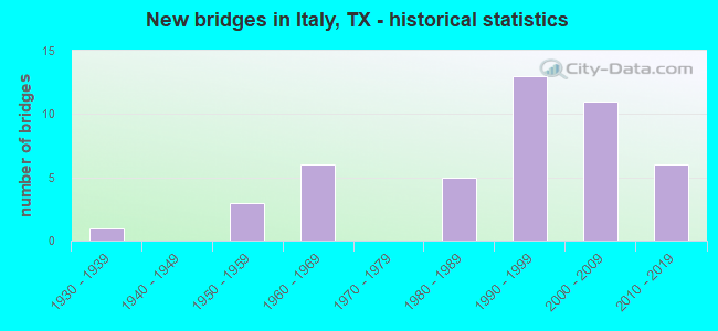
- New bridges - historical statistics
- 11930-1939
- 31950-1959
- 61960-1969
- 51980-1989
- 131990-1999
- 112000-2009
- 62010-2019
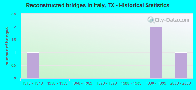
- Reconstructed bridges - Historical Statistics
- 11940-1949
- 01950-1959
- 01960-1969
- 01970-1979
- 01980-1989
- 21990-1999
- 12000-2009
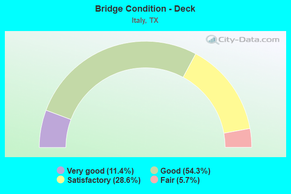
- Bridge Condition - Deck
- 11.4%Very good
- 54.3%Good
- 28.6%Satisfactory
- 5.7%Fair
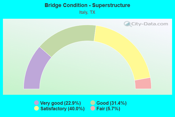
- Bridge Condition - Superstructure
- 22.9%Very good
- 31.4%Good
- 40.0%Satisfactory
- 5.7%Fair
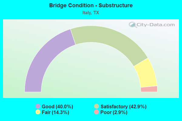
- Bridge Condition - Substructure
- 40.0%Good
- 42.9%Satisfactory
- 14.3%Fair
- 2.9%Poor
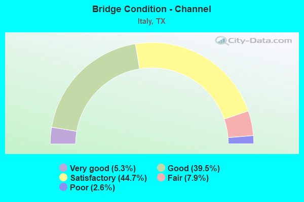
- Bridge Condition - Channel
- 5.3%Very good
- 39.5%Good
- 44.7%Satisfactory
- 7.9%Fair
- 2.6%Poor
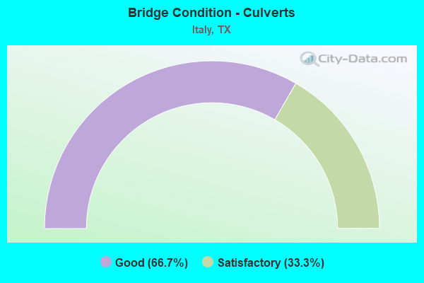
- Bridge Condition - Culverts
- 66.7%Good
- 33.3%Satisfactory
Find on map >> Show street view
Structure Number: 180710004805019, Location: 0.3 MI N OF SH 34 (Lat: 32.186414, Lng: -96.888019), Route carried "on" structure: US 77, Year Built: 1930, Year Reconstructed: 1945, Status: Open, Structure Length: 0.88m (2.89ft), Average Daily Traffic: 2,380 (year 2020), Truck Traffic: 6%, Average Future Daily Traffic: 2,780 (year 2033), Design Load: H 15, Features Intersected: HOUSTON CREEK
Minimum Vertical Clearance: 30+ m (98+ ft), Kilometerpoint: 66.731, Lanes on structure: 2, Owner: State Highway Agency, Approaching Roadway Width: 11.0m (36.1ft), Material/Design: Concrete, Design/Construction: Tee Beam, Number Of Spans In Main Unit: 1, Length of Maximum Span: 8.5m (27.9ft), Curb-To-Curb Width: 11.1m (36.4ft), Out-to-Out Width: 13.1m (43.0ft)
Condition: Deck: Good, Superstructure: Good, Substructure: Satisfactory, Channel: Satisfactory, Operating Rating: 68.0 metric tons, Method Used To Determine Operating Rating: Load Factor (LF), Inventory Rating: 40.8 metric tons, Method Used To Determine Inventory Rating: Load Factor (LF), Structural Evaluation: Equal to present minimum criteria, Deck Geometry: Somewhat better than minimum adequacy, Waterway Adequacy: Equal to present minimum criteria, Approach Roadway Alignment: Equal to present desirable criteria, Designated Inspection Frequency: Every 24 months, Inspection Date: October 2021, Deck Structure Type: Concrete Cast-file-Place, Wearing Surface/Protective System: Wearing Surface: Bituminous
Find on map >> Show street view
Structure Number: 180710004805145, Location: 3.2 MI N OF SH 34 (Lat: 32.226614, Lng: -96.874408), Route carried "on" structure: US 77, Year Built: 1993, Status: Open, Structure Length: 46.33m (152.00ft), Average Daily Traffic: 2,380 (year 2020), Truck Traffic: 6%, Average Future Daily Traffic: 2,780 (year 2033), Design Load: HS 20, Features Intersected: CHAMBERS CREEK RELIEF
Minimum Vertical Clearance: 30+ m (98+ ft), Kilometerpoint: 61.445, Lanes on structure: 2, Owner: State Highway Agency, Approaching Roadway Width: 13.4m (44.0ft), Material/Design: Prestressed concrete, Design/Construction: Stringer/Multi-beam, Number Of Spans In Main Unit: 19, Length of Maximum Span: 24.4m (80.1ft), Curb-To-Curb Width: 13.2m (43.3ft), Out-to-Out Width: 14.0m (45.9ft)
Condition: Deck: Very good, Superstructure: Very good, Substructure: Good, Channel: Good, Operating Rating: 54.4 metric tons, Method Used To Determine Operating Rating: Assigned rating based on Load Factor Design (LFD) reported in metric tons, Inventory Rating: 32.7 metric tons, Method Used To Determine Inventory Rating: Assigned rating based on Load Factor Design (LFD) reported in metric tons, Structural Evaluation: Better than present minimum criteria, Deck Geometry: Equal to present minimum criteria, Waterway Adequacy: Superior to present desirable criteria, Approach Roadway Alignment: Equal to present minimum criteria, Designated Inspection Frequency: Every 24 months, Inspection Date: November 2021, Deck Structure Type: Corrugated Steel, Wearing Surface/Protective System: Wearing Surface: Monolithic Concrete
Find on map >> Show street view
Structure Number: 180710004805146, Location: 3.0 MI N OF SH 34 (Lat: 32.224008, Lng: -96.875717), Route carried "on" structure: US 77, Year Built: 1993, Status: Open, Structure Length: 7.62m (25.00ft), Average Daily Traffic: 2,380 (year 2020), Truck Traffic: 6%, Average Future Daily Traffic: 2,780 (year 2033), Design Load: HS 20, Features Intersected: CHAMBERS CREEK
Minimum Vertical Clearance: 30+ m (98+ ft), Kilometerpoint: 62.137, Lanes on structure: 2, Owner: State Highway Agency, Approaching Roadway Width: 9.1m (29.9ft), Material/Design: Prestressed concrete, Design/Construction: Stringer/Multi-beam, Number Of Spans In Main Unit: 1, Number Of Approach Spans: 2, Length of Maximum Span: 36.6m (120.1ft), Curb-To-Curb Width: 13.1m (43.0ft), Out-to-Out Width: 14.0m (45.9ft)
Condition: Deck: Good, Superstructure: Very good, Substructure: Fair, Channel: Poor, Operating Rating: 54.4 metric tons, Method Used To Determine Operating Rating: Assigned rating based on Load Factor Design (LFD) reported in metric tons, Inventory Rating: 32.7 metric tons, Method Used To Determine Inventory Rating: Assigned rating based on Load Factor Design (LFD) reported in metric tons, Structural Evaluation: Somewhat better than minimum adequacy, Deck Geometry: Equal to present minimum criteria, Waterway Adequacy: Superior to present desirable criteria, Approach Roadway Alignment: Equal to present desirable criteria, Designated Inspection Frequency: Every 24 months, Inspection Date: November 2021, Deck Structure Type: Concrete Cast-file-Place
Find on map >> Show street view
Structure Number: 180710004805166, Location: 1.5 MI SW OF SH 34 (Lat: 32.167508, Lng: -96.907569), Route carried "on" structure: US 77, Year Built: 2003, Status: Open, Structure Length: 4.33m (14.21ft), Average Daily Traffic: 2,448 (year 2020), Truck Traffic: 14%, Average Future Daily Traffic: 3,910 (year 2031), Design Load: HS 20, Features Intersected: HOG CREEK
Minimum Vertical Clearance: 30+ m (98+ ft), Kilometerpoint: 69.548, Lanes on structure: 2, Owner: State Highway Agency, Approaching Roadway Width: 13.4m (44.0ft), Skew: 3 degrees, Material/Design: Prestressed concrete, Design/Construction: Stringer/Multi-beam, Number Of Spans In Main Unit: 2, Length of Maximum Span: 25.9m (85.0ft), Curb-To-Curb Width: 13.2m (43.3ft), Out-to-Out Width: 14.0m (45.9ft)
Condition: Deck: Good, Superstructure: Very good, Substructure: Good, Channel: Good, Operating Rating: 54.4 metric tons, Method Used To Determine Operating Rating: Assigned rating based on Load Factor Design (LFD) reported in metric tons, Inventory Rating: 32.7 metric tons, Method Used To Determine Inventory Rating: Assigned rating based on Load Factor Design (LFD) reported in metric tons, Structural Evaluation: Better than present minimum criteria, Deck Geometry: Equal to present minimum criteria, Waterway Adequacy: Superior to present desirable criteria, Approach Roadway Alignment: Equal to present desirable criteria, Designated Inspection Frequency: Every 24 months, Inspection Date: March 2020, Deck Structure Type: Concrete Precast Panels
Find on map >> Show street view
Structure Number: 180710004808066, Location: 8.9 MI S OF FM 66 (Lat: 32.246422, Lng: -96.875569), Route carried "on" structure: County highway 319, Year Built: 2010, Status: Open, Structure Length: 7.92m (25.98ft), Average Daily Traffic: 200 (year 2011), Average Future Daily Traffic: 52,542 (year 2031), Design Load: HS 25 or greater, Features Intersected: IH 35E
Minimum Vertical Clearance: 30+ m (98+ ft), Kilometerpoint: 18.337, Lanes on structure: 2, Lanes under structure: 6, Owner: State Highway Agency, Approaching Roadway Width: 6.1m (20.0ft), Skew: 1 degrees, Material/Design: Prestressed concrete, Design/Construction: Stringer/Multi-beam, Number Of Spans In Main Unit: 4, Length of Maximum Span: 21.3m (69.9ft), Curb-To-Curb Width: 13.1m (43.0ft), Out-to-Out Width: 14.0m (45.9ft)
Condition: Deck: Good, Superstructure: Very good, Substructure: Good, Operating Rating: 68.0 metric tons, Method Used To Determine Operating Rating: Assigned rating based on Load Factor Design (LFD) reported in metric tons, Inventory Rating: 40.8 metric tons, Method Used To Determine Inventory Rating: Assigned rating based on Load Factor Design (LFD) reported in metric tons, Structural Evaluation: Better than present minimum criteria, Deck Geometry: Superior to present desirable criteria, Underclear: Equal to present minimum criteria, Approach Roadway Alignment: Equal to present desirable criteria, Designated Inspection Frequency: Every 24 months, Inspection Date: October 2021, Deck Structure Type: Concrete Cast-file-Place
Find on map >> Show street view
Structure Number: 180710004808099, Location: 0.2 MI N OF SH 34 (Lat: 32.198844, Lng: -96.898186), Route carried "on" structure: ServiceInterstate 35, Year Built: 1966, Year Reconstructed: 2005, Status: Open, Structure Length: 0.73m (2.40ft), Average Daily Traffic: 2,950 (year 2016), Truck Traffic: 3%, Average Future Daily Traffic: 4,280 (year 2036), Features Intersected: DRAINAGE DITCH
Minimum Vertical Clearance: 30+ m (98+ ft), Kilometerpoint: 12.458, Lanes on structure: 2, Owner: State Highway Agency, Approaching Roadway Width: 6.7m (22.0ft), Skew: 1 degrees, Material/Design: Concrete, Design/Construction: Culvert, Number Of Spans In Main Unit: 3, Length of Maximum Span: 2.1m (6.9ft), Curb-To-Curb Width: 13.6m (44.6ft), Out-to-Out Width: 15.1m (49.5ft)
Condition: Channel: Satisfactory, Culverts: Good, Operating Rating: 44.4 metric tons, Method Used To Determine Operating Rating: No rating analysis performed, Inventory Rating: 32.7 metric tons, Method Used To Determine Inventory Rating: No rating analysis performed, Structural Evaluation: Better than present minimum criteria, Deck Geometry: Superior to present desirable criteria, Waterway Adequacy: Equal to present minimum criteria, Approach Roadway Alignment: Equal to present desirable criteria, Designated Inspection Frequency: Every 24 months, Inspection Date: October 2021, Deck Structure Type: Concrete Cast-file-Place, Wearing Surface/Protective System: Wearing Surface: Bituminous
Find on map >> Show street view
Structure Number: 1807100048081, Location: 0.2 MI N OF SH 34 (Lat: 32.198725, Lng: -96.897789), Route carried "on" structure: Interstate 35, Year Built: 1966, Status: Open, Structure Length: 0.73m (2.40ft), Average Daily Traffic: 35,407 (year 2020), Truck Traffic: 37%, Average Future Daily Traffic: 42,730 (year 2033), Features Intersected: DRAINAGE DITCH
Minimum Vertical Clearance: 30+ m (98+ ft), Kilometerpoint: 12.450, Lanes on structure: 6, Owner: State Highway Agency, Approaching Roadway Width: 34.1m (111.9ft), Skew: 31 degrees, Material/Design: Concrete, Design/Construction: Culvert, Number Of Spans In Main Unit: 3, Length of Maximum Span: 2.1m (6.9ft)
Condition: Channel: Satisfactory, Culverts: Good, Operating Rating: 44.4 metric tons, Method Used To Determine Operating Rating: No rating analysis performed, Inventory Rating: 32.7 metric tons, Method Used To Determine Inventory Rating: No rating analysis performed, Structural Evaluation: Better than present minimum criteria, Waterway Adequacy: Superior to present desirable criteria, Approach Roadway Alignment: Equal to present desirable criteria, Designated Inspection Frequency: Every 24 months, Inspection Date: October 2021
Find on map >> Show street view
Structure Number: 180710004808101, Location: 0.2 MI N OF SH 34 (Lat: 32.198578, Lng: -96.897464), Route carried "on" structure: ServiceInterstate 35, Year Built: 1966, Status: Open, Structure Length: 0.73m (2.40ft), Average Daily Traffic: 2,950 (year 2011), Truck Traffic: 3%, Average Future Daily Traffic: 4,280 (year 2031), Features Intersected: DRAINAGE DITCH
Minimum Vertical Clearance: 30+ m (98+ ft), Kilometerpoint: 12.431, Lanes on structure: 2, Owner: State Highway Agency, Approaching Roadway Width: 6.7m (22.0ft), Skew: 1 degrees, Material/Design: Concrete, Design/Construction: Culvert, Number Of Spans In Main Unit: 3, Length of Maximum Span: 2.1m (6.9ft), Curb-To-Curb Width: 15.9m (52.2ft), Out-to-Out Width: 16.2m (53.1ft)
Condition: Channel: Good, Culverts: Good, Operating Rating: 44.4 metric tons, Method Used To Determine Operating Rating: No rating analysis performed, Inventory Rating: 32.7 metric tons, Method Used To Determine Inventory Rating: No rating analysis performed, Structural Evaluation: Better than present minimum criteria, Deck Geometry: Superior to present desirable criteria, Waterway Adequacy: Equal to present minimum criteria, Approach Roadway Alignment: Equal to present desirable criteria, Designated Inspection Frequency: Every 24 months, Inspection Date: October 2021, Deck Structure Type: Concrete Cast-file-Place, Wearing Surface/Protective System: Wearing Surface: Bituminous
Find on map >> Show street view
Structure Number: 18071000480811, Location: 1.2 MI S OF SH 34 (Lat: 32.172906, Lng: -96.911019), Route carried "on" structure: ServiceInterstate 35, Year Built: 1966, Status: Open, Structure Length: 1.95m (6.40ft), Average Daily Traffic: 16,370 (year 2013), Truck Traffic: 12%, Average Future Daily Traffic: 22,910 (year 2033), Design Load: H 15, Features Intersected: HOG CREEK
Minimum Vertical Clearance: 30+ m (98+ ft), Kilometerpoint: 9.352, Lanes on structure: 2, Owner: State Highway Agency, Approaching Roadway Width: 5.5m (18.0ft), Skew: 2 degrees, Material/Design: Concrete, Design/Construction: Stringer/Multi-beam, Number Of Spans In Main Unit: 2, Length of Maximum Span: 9.8m (32.2ft), Curb-To-Curb Width: 7.3m (24.0ft), Out-to-Out Width: 7.8m (25.6ft)
Condition: Deck: Good, Superstructure: Good, Substructure: Satisfactory, Channel: Satisfactory, Operating Rating: 54.4 metric tons, Method Used To Determine Operating Rating: Load Factor (LF), Inventory Rating: 31.7 metric tons, Method Used To Determine Inventory Rating: Load Factor (LF), Structural Evaluation: Equal to present minimum criteria, Deck Geometry: High priority of replacement, Waterway Adequacy: Equal to present minimum criteria, Approach Roadway Alignment: Equal to present desirable criteria, Length Of Structure Improvement: 1.95m (6.40ft), Designated Inspection Frequency: Every 24 months, Inspection Date: October 2021, Bridge Improvement Cost: $3,000, Roadway Improvement Cost: $1,000, Total Project Cost: $4,000, Deck Structure Type: Concrete Cast-file-Place
Find on map >> Show street view
Structure Number: 180710004808111, Location: 2.0 MI SE OF SH 34 (Lat: 32.170053, Lng: -96.913894), Route carried "on" structure: Interstate 35, Year Built: 1966, Status: Open, Structure Length: 1.19m (3.90ft), Average Daily Traffic: 33,458 (year 2020), Truck Traffic: 37%, Average Future Daily Traffic: 42,860 (year 2033), Features Intersected: DRAW
Minimum Vertical Clearance: 30+ m (98+ ft), Kilometerpoint: 8.916, Lanes on structure: 6, Owner: State Highway Agency, Approaching Roadway Width: 34.7m (113.8ft), Skew: 33 degrees, Material/Design: Concrete, Design/Construction: Culvert, Number Of Spans In Main Unit: 5, Length of Maximum Span: 1.8m (5.9ft)
Condition: Channel: Good, Culverts: Satisfactory, Operating Rating: 39.9 metric tons, Method Used To Determine Operating Rating: Load Factor (LF), Inventory Rating: 23.6 metric tons, Method Used To Determine Inventory Rating: Load Factor (LF), Structural Evaluation: Somewhat better than minimum adequacy, Waterway Adequacy: Equal to present minimum criteria, Approach Roadway Alignment: Equal to present desirable criteria, Designated Inspection Frequency: Every 24 months, Inspection Date: November 2021
Find on map >> Show street view
Structure Number: 180710004808124, Location: 2.8 MI N OF SH 34 (Lat: 32.234200, Lng: -96.880639), Route carried "on" structure: Interstate 35, Year Built: 2010, Status: Open, Structure Length: 39.62m (129.99ft), Average Daily Traffic: 35,407 (year 2020), Truck Traffic: 37%, Average Future Daily Traffic: 42,730 (year 2033), Design Load: HS 25 or greater, Features Intersected: CHAMBERS CREEK RELIEF
Minimum Vertical Clearance: 30+ m (98+ ft), Kilometerpoint: 16.715, Lanes on structure: 6, Owner: State Highway Agency, Approaching Roadway Width: 34.7m (113.8ft), Material/Design: Prestressed concrete, Design/Construction: Stringer/Multi-beam, Number Of Spans In Main Unit: 21, Length of Maximum Span: 22.9m (75.1ft), Curb-To-Curb Width: 34.6m (113.5ft), Out-to-Out Width: 36.0m (118.1ft)
Condition: Deck: Satisfactory, Superstructure: Very good, Substructure: Good, Channel: Good, Operating Rating: 68.0 metric tons, Method Used To Determine Operating Rating: Assigned rating based on Load Factor Design (LFD) reported in metric tons, Inventory Rating: 40.8 metric tons, Method Used To Determine Inventory Rating: Assigned rating based on Load Factor Design (LFD) reported in metric tons, Structural Evaluation: Better than present minimum criteria, Deck Geometry: Superior to present desirable criteria, Waterway Adequacy: Superior to present desirable criteria, Approach Roadway Alignment: Equal to present desirable criteria, Designated Inspection Frequency: Every 24 months, Inspection Date: November 2021, Deck Structure Type: Concrete Precast Panels
Find on map >> Show street view
Structure Number: 180710004808125, Location: 2.6 MI N OF SH 34 (Lat: 32.231250, Lng: -96.882231), Route carried "on" structure: Interstate 35, Year Built: 2010, Status: Open, Structure Length: 10.97m (35.99ft), Average Daily Traffic: 35,407 (year 2020), Truck Traffic: 7%, Average Future Daily Traffic: 43,400 (year 2031), Design Load: HS 25 or greater, Features Intersected: CHAMBERS CREEK
Minimum Vertical Clearance: 30+ m (98+ ft), Kilometerpoint: 5.745, Lanes on structure: 5, Owner: State Highway Agency, Approaching Roadway Width: 34.7m (113.8ft), Material/Design: Prestressed concrete, Design/Construction: Stringer/Multi-beam, Number Of Spans In Main Unit: 5, Length of Maximum Span: 24.4m (80.1ft), Curb-To-Curb Width: 34.6m (113.5ft), Out-to-Out Width: 36.0m (118.1ft)
Condition: Deck: Good, Superstructure: Very good, Substructure: Satisfactory, Channel: Satisfactory, Operating Rating: 68.0 metric tons, Method Used To Determine Operating Rating: Assigned rating based on Load Factor Design (LFD) reported in metric tons, Inventory Rating: 40.8 metric tons, Method Used To Determine Inventory Rating: Assigned rating based on Load Factor Design (LFD) reported in metric tons, Structural Evaluation: Equal to present minimum criteria, Deck Geometry: Superior to present desirable criteria, Waterway Adequacy: Superior to present desirable criteria, Approach Roadway Alignment: Equal to present desirable criteria, Designated Inspection Frequency: Every 24 months, Inspection Date: November 2021, Deck Structure Type: Concrete Precast Panels
Find on map >> Show street view
Structure Number: 180710004808172, Location: 1.2 MI S OF SH 34 (Lat: 32.173064, Lng: -96.911247), Route carried "on" structure: Interstate 35, Year Built: 2007, Status: Open, Structure Length: 3.81m (12.50ft), Average Daily Traffic: 19,129 (year 2019), Truck Traffic: 37%, Average Future Daily Traffic: 21,430 (year 2033), Design Load: HS 25 or greater, Features Intersected: HOG CREEK
Minimum Vertical Clearance: 30+ m (98+ ft), Kilometerpoint: 9.347, Lanes on structure: 3, Owner: State Highway Agency, Approaching Roadway Width: 17.7m (58.1ft), Skew: 2 degrees, Material/Design: Prestressed concrete, Design/Construction: Stringer/Multi-beam, Number Of Spans In Main Unit: 1, Length of Maximum Span: 38.1m (125.0ft), Curb-To-Curb Width: 17.2m (56.4ft), Out-to-Out Width: 18.0m (59.1ft)
Condition: Deck: Good, Superstructure: Good, Substructure: Good, Channel: Good, Operating Rating: 68.0 metric tons, Method Used To Determine Operating Rating: Assigned rating based on Load Factor Design (LFD) reported in metric tons, Inventory Rating: 40.8 metric tons, Method Used To Determine Inventory Rating: Assigned rating based on Load Factor Design (LFD) reported in metric tons, Structural Evaluation: Better than present minimum criteria, Deck Geometry: Better than present minimum criteria, Waterway Adequacy: Superior to present desirable criteria, Approach Roadway Alignment: Equal to present desirable criteria, Designated Inspection Frequency: Every 24 months, Inspection Date: October 2021, Deck Structure Type: Concrete Cast-file-Place
Find on map >> Show street view
Structure Number: 180710004808173, Location: 1.2 MI S OF SH 34 (Lat: 32.173692, Lng: -96.911297), Route carried "on" structure: Interstate 35, Year Built: 2007, Status: Open, Structure Length: 3.81m (12.50ft), Average Daily Traffic: 18,891 (year 2019), Truck Traffic: 37%, Average Future Daily Traffic: 21,430 (year 2033), Design Load: HS 25 or greater, Features Intersected: HOG CREEK
Minimum Vertical Clearance: 30+ m (98+ ft), Kilometerpoint: 9.354, Lanes on structure: 4, Owner: State Highway Agency, Approaching Roadway Width: 17.7m (58.1ft), Skew: 2 degrees, Material/Design: Prestressed concrete, Design/Construction: Stringer/Multi-beam, Number Of Spans In Main Unit: 1, Length of Maximum Span: 38.1m (125.0ft), Curb-To-Curb Width: 23.3m (76.4ft), Out-to-Out Width: 24.1m (79.1ft)
Condition: Deck: Good, Superstructure: Good, Substructure: Good, Channel: Good, Operating Rating: 68.0 metric tons, Method Used To Determine Operating Rating: Assigned rating based on Load Factor Design (LFD) reported in metric tons, Inventory Rating: 40.8 metric tons, Method Used To Determine Inventory Rating: Assigned rating based on Load Factor Design (LFD) reported in metric tons, Structural Evaluation: Better than present minimum criteria, Deck Geometry: Superior to present desirable criteria, Waterway Adequacy: Superior to present desirable criteria, Approach Roadway Alignment: Equal to present desirable criteria, Designated Inspection Frequency: Every 24 months, Inspection Date: October 2021, Deck Structure Type: Concrete Cast-file-Place
Find on map >> Show street view
Structure Number: 180710004808174, Location: 1.4 MI S OF SH 34 (Lat: 32.177128, Lng: -96.909294), Route carried "on" structure: Interstate 35, Year Built: 2007, Status: Open, Structure Length: 7.01m (23.00ft), Average Daily Traffic: 33,458 (year 2020), Truck Traffic: 37%, Average Future Daily Traffic: 42,860 (year 2033), Design Load: HS 25 or greater, Features Intersected: DERRS CHAPEL RD
Minimum Vertical Clearance: 30+ m (98+ ft), Kilometerpoint: 9.762, Lanes on structure: 6, Lanes under structure: 2, Owner: State Highway Agency, Approaching Roadway Width: 34.7m (113.8ft), Skew: 30 degrees, Material/Design: Prestressed concrete, Design/Construction: Box Beam or Girders - Multiple, Number Of Spans In Main Unit: 2, Number Of Approach Spans: 1, Length of Maximum Span: 27.4m (89.9ft), Curb-To-Curb Width: 34.6m (113.5ft), Out-to-Out Width: 36.0m (118.1ft)
Condition: Deck: Good, Superstructure: Good, Substructure: Good, Operating Rating: 68.0 metric tons, Method Used To Determine Operating Rating: Assigned rating based on Load Factor Design (LFD) reported in metric tons, Inventory Rating: 40.8 metric tons, Method Used To Determine Inventory Rating: Assigned rating based on Load Factor Design (LFD) reported in metric tons, Structural Evaluation: Better than present minimum criteria, Deck Geometry: Superior to present desirable criteria, Underclear: Superior to present desirable criteria, Approach Roadway Alignment: Equal to present desirable criteria, Designated Inspection Frequency: Every 24 months, Inspection Date: November 2021, Deck Structure Type: Concrete Cast-file-Place
Find on map >> Show street view
Structure Number: 180710004808179, Location: 0.5 MI S OF SH 34 (Lat: 32.189378, Lng: -96.902767), Route carried "on" structure: Interstate 35, Year Built: 2007, Status: Open, Structure Length: 3.35m (10.99ft), Average Daily Traffic: 33,458 (year 2020), Truck Traffic: 37%, Average Future Daily Traffic: 42,860 (year 2033), Design Load: HS 25 or greater, Features Intersected: HOUSTON CREEK
Minimum Vertical Clearance: 30+ m (98+ ft), Kilometerpoint: 11.272, Lanes on structure: 6, Owner: State Highway Agency, Approaching Roadway Width: 34.7m (113.8ft), Skew: 33 degrees, Material/Design: Prestressed concrete, Design/Construction: Stringer/Multi-beam, Number Of Spans In Main Unit: 1, Length of Maximum Span: 33.5m (109.9ft), Curb-To-Curb Width: 34.6m (113.5ft), Out-to-Out Width: 36.0m (118.1ft)
Condition: Deck: Good, Superstructure: Good, Substructure: Good, Channel: Good, Operating Rating: 68.0 metric tons, Method Used To Determine Operating Rating: Assigned rating based on Load Factor Design (LFD) reported in metric tons, Inventory Rating: 40.8 metric tons, Method Used To Determine Inventory Rating: Assigned rating based on Load Factor Design (LFD) reported in metric tons, Structural Evaluation: Better than present minimum criteria, Deck Geometry: Superior to present desirable criteria, Waterway Adequacy: Superior to present desirable criteria, Approach Roadway Alignment: Equal to present desirable criteria, Designated Inspection Frequency: Every 24 months, Inspection Date: November 2021, Deck Structure Type: Corrugated Steel, Wearing Surface/Protective System: Wearing Surface: Monolithic Concrete
Find on map >> Show street view
Structure Number: 180710004808181, Location: IH 35E AT SH 34 (Lat: 32.196433, Lng: -96.899325), Route carried "on" structure: Interstate 35, Year Built: 2007, Status: Open, Structure Length: 6.71m (22.01ft), Average Daily Traffic: 35,407 (year 2020), Truck Traffic: 37%, Average Future Daily Traffic: 42,860 (year 2033), Design Load: HS 25 or greater, Features Intersected: SH 34
Minimum Vertical Clearance: 30+ m (98+ ft), Kilometerpoint: 12.097, Lanes on structure: 6, Lanes under structure: 2, Owner: State Highway Agency, Approaching Roadway Width: 34.7m (113.8ft), Skew: 31 degrees, Material/Design: Prestressed concrete, Design/Construction: Box Beam or Girders - Multiple, Number Of Spans In Main Unit: 1, Number Of Approach Spans: 2, Length of Maximum Span: 30.5m (100.1ft), Curb-To-Curb Width: 34.6m (113.5ft), Out-to-Out Width: 36.0m (118.1ft)
Condition: Deck: Satisfactory, Superstructure: Good, Substructure: Good, Operating Rating: 68.0 metric tons, Method Used To Determine Operating Rating: Assigned rating based on Load Factor Design (LFD) reported in metric tons, Inventory Rating: 40.8 metric tons, Method Used To Determine Inventory Rating: Assigned rating based on Load Factor Design (LFD) reported in metric tons, Structural Evaluation: Better than present minimum criteria, Deck Geometry: Superior to present desirable criteria, Underclear: Superior to present desirable criteria, Approach Roadway Alignment: Equal to present desirable criteria, Designated Inspection Frequency: Every 24 months, Inspection Date: October 2021, Deck Structure Type: Concrete Cast-file-Place
Find on map >> Show street view
Structure Number: 180710004808182, Location: 1.8 MI N OF SH 34 (Lat: 32.220433, Lng: -96.887881), Route carried "on" structure: Interstate 35, Year Built: 2007, Status: Open, Structure Length: 8.38m (27.49ft), Average Daily Traffic: 35,407 (year 2020), Truck Traffic: 37%, Average Future Daily Traffic: 42,730 (year 2033), Design Load: HS 25 or greater, Features Intersected: DRAW AND CHAMBERS DR
Minimum Vertical Clearance: 30+ m (98+ ft), Kilometerpoint: 14.959, Lanes on structure: 6, Lanes under structure: 2, Owner: State Highway Agency, Approaching Roadway Width: 34.7m (113.8ft), Skew: 30 degrees, Material/Design: Prestressed concrete, Design/Construction: Stringer/Multi-beam, Number Of Spans In Main Unit: 1, Number Of Approach Spans: 2, Length of Maximum Span: 38.1m (125.0ft), Curb-To-Curb Width: 34.6m (113.5ft), Out-to-Out Width: 36.0m (118.1ft)
Condition: Deck: Good, Superstructure: Good, Substructure: Good, Channel: Good, Operating Rating: 68.0 metric tons, Method Used To Determine Operating Rating: Assigned rating based on Load Factor Design (LFD) reported in metric tons, Inventory Rating: 40.8 metric tons, Method Used To Determine Inventory Rating: Assigned rating based on Load Factor Design (LFD) reported in metric tons, Structural Evaluation: Better than present minimum criteria, Deck Geometry: Superior to present desirable criteria, Underclear: Superior to present desirable criteria, Waterway Adequacy: Superior to present desirable criteria, Approach Roadway Alignment: Equal to present desirable criteria, Designated Inspection Frequency: Every 24 months, Inspection Date: October 2021, Deck Structure Type: Concrete Cast-file-Place
Find on map >> Show street view
Structure Number: 180710056801033, Location: 4.0 MI E OF US 77 (Lat: 32.186089, Lng: -96.823911), Route carried "on" structure: State highway 34, Year Built: 1981, Status: Open, Structure Length: 6.10m (20.01ft), Average Daily Traffic: 2,219 (year 2020), Truck Traffic: 24%, Average Future Daily Traffic: 3,020 (year 2033), Design Load: HS 20, Features Intersected: CHAMBERS CREEK SLOUGH
Minimum Vertical Clearance: 30+ m (98+ ft), Kilometerpoint: 40.938, Lanes on structure: 2, Owner: State Highway Agency, Approaching Roadway Width: 11.0m (36.1ft), Material/Design: Concrete, Design/Construction: Stringer/Multi-beam, Number Of Spans In Main Unit: 5, Length of Maximum Span: 12.2m (40.0ft), Curb-To-Curb Width: 12.1m (39.7ft), Out-to-Out Width: 12.9m (42.3ft)
Condition: Deck: Good, Superstructure: Good, Substructure: Good, Channel: Satisfactory, Operating Rating: 68.0 metric tons, Method Used To Determine Operating Rating: Load Factor (LF), Inventory Rating: 40.8 metric tons, Method Used To Determine Inventory Rating: Load Factor (LF), Structural Evaluation: Better than present minimum criteria, Deck Geometry: Somewhat better than minimum adequacy, Waterway Adequacy: Superior to present desirable criteria, Approach Roadway Alignment: Equal to present desirable criteria, Designated Inspection Frequency: Every 24 months, Inspection Date: October 2021, Deck Structure Type: Concrete Cast-file-Place
Find on map >> Show street view
Structure Number: 180710056801034, Location: 2.30 MI E OF FM 667 (Lat: 32.185583, Lng: -96.835397), Route carried "on" structure: State highway 34, Year Built: 1981, Status: Open, Structure Length: 20.57m (67.49ft), Average Daily Traffic: 2,219 (year 2020), Truck Traffic: 24%, Average Future Daily Traffic: 3,020 (year 2033), Design Load: HS 20, Features Intersected: CHAMBERS CREEK
Minimum Vertical Clearance: 30+ m (98+ ft), Kilometerpoint: 41.888, Lanes on structure: 2, Owner: State Highway Agency, Approaching Roadway Width: 11.6m (38.1ft), Material/Design: Prestressed concrete, Design/Construction: Stringer/Multi-beam, Number Of Spans In Main Unit: 9, Length of Maximum Span: 22.9m (75.1ft), Curb-To-Curb Width: 12.2m (40.0ft), Out-to-Out Width: 12.9m (42.3ft)
Condition: Deck: Good, Superstructure: Good, Substructure: Satisfactory, Channel: Fair, Operating Rating: 54.4 metric tons, Method Used To Determine Operating Rating: Assigned rating based on Load Factor Design (LFD) reported in metric tons, Inventory Rating: 32.7 metric tons, Method Used To Determine Inventory Rating: Assigned rating based on Load Factor Design (LFD) reported in metric tons, Structural Evaluation: Equal to present minimum criteria, Deck Geometry: Equal to present minimum criteria, Waterway Adequacy: Superior to present desirable criteria, Approach Roadway Alignment: Equal to present desirable criteria, Designated Inspection Frequency: Every 24 months, Inspection Date: October 2021, Deck Structure Type: Concrete Cast-file-Place
Find on map >> Show street view
Structure Number: 180710074701018, Location: 0.75 MI SE OF SH 34 (Lat: 32.171328, Lng: -96.870358), Route carried "on" structure: State highway 667, Year Built: 1954, Status: Open, Structure Length: 2.29m (7.51ft), Average Daily Traffic: 1,392 (year 2020), Truck Traffic: 13%, Average Future Daily Traffic: 1,760 (year 2033), Design Load: H 15, Features Intersected: WHITE ROCK BRANCH
Minimum Vertical Clearance: 30+ m (98+ ft), Kilometerpoint: 2.847, Lanes on structure: 2, Owner: State Highway Agency, Approaching Roadway Width: 6.1m (20.0ft), Material/Design: Concrete, Design/Construction: Slab, Number Of Spans In Main Unit: 3, Length of Maximum Span: 7.6m (24.9ft), Curb-To-Curb Width: 7.1m (23.3ft), Out-to-Out Width: 7.7m (25.3ft)
Condition: Deck: Fair, Superstructure: Fair, Substructure: Satisfactory, Channel: Satisfactory, Operating Rating: 51.7 metric tons, Method Used To Determine Operating Rating: Load Factor (LF), Inventory Rating: 27.2 metric tons, Method Used To Determine Inventory Rating: Load Factor (LF), Structural Evaluation: Somewhat better than minimum adequacy, Deck Geometry: High priority of corrective action, Waterway Adequacy: Equal to present minimum criteria, Approach Roadway Alignment: Equal to present desirable criteria, Length Of Structure Improvement: 2.29m (7.51ft), Designated Inspection Frequency: Every 24 months, Inspection Date: March 2020, Bridge Improvement Cost: $3,000, Roadway Improvement Cost: $1,000, Total Project Cost: $4,000, Deck Structure Type: Concrete Cast-file-Place, Wearing Surface/Protective System: Wearing Surface: Bituminous
Find on map >> Show street view
Structure Number: 180710074701019, Location: 3.75 MI SE OF SH 34 (Lat: 32.136275, Lng: -96.844556), Route carried "on" structure: State highway 667, Year Built: 1954, Status: Open, Structure Length: 5.33m (17.49ft), Average Daily Traffic: 1,090 (year 2020), Truck Traffic: 7%, Average Future Daily Traffic: 990 (year 2033), Design Load: H 15, Features Intersected: HOG CREEK
Minimum Vertical Clearance: 30+ m (98+ ft), Kilometerpoint: 7.475, Lanes on structure: 2, Owner: State Highway Agency, Approaching Roadway Width: 6.7m (22.0ft), Material/Design: Concrete, Design/Construction: Slab, Number Of Spans In Main Unit: 7, Length of Maximum Span: 7.6m (24.9ft), Curb-To-Curb Width: 7.1m (23.3ft), Out-to-Out Width: 7.7m (25.3ft)
Condition: Deck: Satisfactory, Superstructure: Satisfactory, Substructure: Satisfactory, Channel: Good, Operating Rating: 51.7 metric tons, Method Used To Determine Operating Rating: Load Factor (LF), Inventory Rating: 27.2 metric tons, Method Used To Determine Inventory Rating: Load Factor (LF), Structural Evaluation: Equal to present minimum criteria, Deck Geometry: High priority of corrective action, Waterway Adequacy: Equal to present minimum criteria, Approach Roadway Alignment: Equal to present desirable criteria, Length Of Structure Improvement: 5.33m (17.49ft), Designated Inspection Frequency: Every 24 months, Inspection Date: March 2020, Bridge Improvement Cost: $8,000, Roadway Improvement Cost: $2,000, Total Project Cost: $10,000, Deck Structure Type: Concrete Cast-file-Place, Wearing Surface/Protective System: Wearing Surface: Bituminous
Find on map >> Show street view
Structure Number: 180710298401001, Location: 0.75 MI SE OF IH 35E (Lat: 32.185900, Lng: -96.892106), Route carried "on" structure: State highway 34, Year Built: 1967, Status: Open, Structure Length: 2.77m (9.09ft), Average Daily Traffic: 4,845 (year 2020), Truck Traffic: 6%, Average Future Daily Traffic: 5,050 (year 2033), Design Load: H 20, Features Intersected: HOUSTON CREEK
Minimum Vertical Clearance: 30+ m (98+ ft), Kilometerpoint: 0.398, Lanes on structure: 2, Owner: State Highway Agency, Approaching Roadway Width: 8.5m (27.9ft), Material/Design: Concrete, Design/Construction: Stringer/Multi-beam, Number Of Spans In Main Unit: 3, Length of Maximum Span: 9.1m (29.9ft), Curb-To-Curb Width: 10.1m (33.1ft), Out-to-Out Width: 10.8m (35.4ft)
Condition: Deck: Good, Superstructure: Good, Substructure: Good, Channel: Satisfactory, Operating Rating: 54.4 metric tons, Method Used To Determine Operating Rating: Load Factor (LF), Inventory Rating: 32.7 metric tons, Method Used To Determine Inventory Rating: Load Factor (LF), Structural Evaluation: Better than present minimum criteria, Deck Geometry: Meets minimum limits, Waterway Adequacy: Equal to present minimum criteria, Approach Roadway Alignment: Equal to present desirable criteria, Designated Inspection Frequency: Every 24 months, Inspection Date: November 2021, Deck Structure Type: Concrete Cast-file-Place, Wearing Surface/Protective System: Wearing Surface: Bituminous
Find on map >> Show street view
Structure Number: 180710298401003, Location: 7.1 MI S OF FM 1493 (Lat: 32.244742, Lng: -96.918436), Route carried "on" structure: State highway 876, Year Built: 1980, Status: Open, Structure Length: 12.50m (41.01ft), Average Daily Traffic: 234 (year 2020), Truck Traffic: 21%, Average Future Daily Traffic: 290 (year 2033), Design Load: H 15, Features Intersected: CHAMBERS CREEK
Minimum Vertical Clearance: 30+ m (98+ ft), Kilometerpoint: 15.838, Lanes on structure: 2, Owner: State Highway Agency, Approaching Roadway Width: 6.1m (20.0ft), Material/Design: Prestressed concrete, Design/Construction: Stringer/Multi-beam, Number Of Spans In Main Unit: 5, Length of Maximum Span: 27.4m (89.9ft), Curb-To-Curb Width: 7.9m (25.9ft), Out-to-Out Width: 8.6m (28.2ft)
Condition: Deck: Very good, Superstructure: Very good, Substructure: Satisfactory, Channel: Satisfactory, Operating Rating: 54.4 metric tons, Method Used To Determine Operating Rating: Load Factor (LF), Inventory Rating: 24.5 metric tons, Method Used To Determine Inventory Rating: Load Factor (LF), Structural Evaluation: Equal to present minimum criteria, Deck Geometry: Somewhat better than minimum adequacy, Waterway Adequacy: High priority of corrective action, Approach Roadway Alignment: Equal to present desirable criteria, Designated Inspection Frequency: Every 24 months, Inspection Date: January 2020, Deck Structure Type: Concrete Cast-file-Place
Find on map >> Show street view
Structure Number: 180710AA0238003, Location: 0.70 MI NE OF FM 876 (Lat: 32.255306, Lng: -96.904722), Route carried "on" structure: County highway , Year Built: 1999, Status: Open, Structure Length: 1.22m (4.00ft), Average Daily Traffic: 10 (year 2015), Average Future Daily Traffic: 124 (year 2035), Features Intersected: CHAMBERS CREEK TRIBUTARY, Facility Carried by Structure: ANDERSON ROAD
Minimum Vertical Clearance: 30+ m (98+ ft), Kilometerpoint: 7.162, Lanes on structure: 1, Owner: County Highway Agency, Approaching Roadway Width: 3.7m (12.1ft), Skew: 1 degrees, Material/Design: Steel continuous, Design/Construction: Stringer/Multi-beam, Number Of Spans In Main Unit: 2, Length of Maximum Span: 5.8m (19.0ft), Curb-To-Curb Width: 4.1m (13.5ft), Out-to-Out Width: 4.7m (15.4ft)
Condition: Deck: Satisfactory, Superstructure: Satisfactory, Substructure: Satisfactory, Channel: Satisfactory, Operating Rating: 68.0 metric tons, Method Used To Determine Operating Rating: Allowable Stress (AS), Inventory Rating: 40.8 metric tons, Method Used To Determine Inventory Rating: Allowable Stress (AS), Structural Evaluation: Equal to present minimum criteria, Deck Geometry: Somewhat better than minimum adequacy, Waterway Adequacy: High priority of corrective action, Approach Roadway Alignment: Meets minimum limits, Length Of Structure Improvement: 1.22m (4.00ft), Designated Inspection Frequency: Every 24 months, Critical Feature Inspection Frequency: Every 24 months, Inspection Date: Febuary 2021, Critical Feature Inspection Date: December 2021, Bridge Improvement Cost: $1,000, Total Project Cost: $1,000, Deck Structure Type: Wood or Timber, Wearing Surface/Protective System: Wearing Surface: Wood or Timber
Find on map >> Show street view
Structure Number: 180710AA0278001, Location: 0.8 MI NE DERRS CHAPEL RD (Lat: 32.186969, Lng: -96.900417), Route carried "on" structure: County highway , Year Built: 1993, Status: Posted for load, Structure Length: 0.98m (3.22ft), Average Daily Traffic: 10 (year 2011), Average Future Daily Traffic: 165 (year 2031), Features Intersected: HOUSTON CREEK, Facility Carried by Structure: JOHN DAVIS ROAD
Minimum Vertical Clearance: 30+ m (98+ ft), Kilometerpoint: 1.287, Lanes on structure: 1, Owner: County Highway Agency, Approaching Roadway Width: 4.3m (14.1ft), Material/Design: Steel, Design/Construction: Stringer/Multi-beam, Number Of Spans In Main Unit: 1, Length of Maximum Span: 9.4m (30.8ft), Curb-To-Curb Width: 5.8m (19.0ft), Out-to-Out Width: 6.2m (20.3ft)
Condition: Deck: Satisfactory, Superstructure: Satisfactory, Substructure: Satisfactory, Channel: Good, Operating Rating: 22.7 metric tons, Method Used To Determine Operating Rating: Allowable Stress (AS), Inventory Rating: 16.3 metric tons, Method Used To Determine Inventory Rating: Allowable Stress (AS), Structural Evaluation: Somewhat better than minimum adequacy, Deck Geometry: Meets minimum limits, Waterway Adequacy: Meets minimum limits, Approach Roadway Alignment: Equal to present minimum criteria, Bridge Posting: Required (Relationship of Operating Rating to Maximum Legal Load: 20.0 - 29.9% below), Designated Inspection Frequency: Every 24 months, Inspection Date: Febuary 2021, Deck Structure Type: Wood or Timber, Wearing Surface/Protective System: Wearing Surface: Wood or Timber
Find on map >> Show street view
Structure Number: 180710AA0294001, Location: 0.6 MI SW OF MORGAN RD (Lat: 32.135267, Lng: -96.898647), Route carried "on" structure: County highway , Year Built: 2008, Status: Open, Structure Length: 0.64m (2.10ft), Average Daily Traffic: 10 (year 2015), Average Future Daily Traffic: 20 (year 2035), Features Intersected: FLAT ROCK BRANCH TRIB, Facility Carried by Structure: JOANNA LANE
Minimum Vertical Clearance: 30+ m (98+ ft), Kilometerpoint: 2.414, Lanes on structure: 1, Owner: County Highway Agency, Approaching Roadway Width: 3.4m (11.2ft), Material/Design: Steel, Design/Construction: Culvert, Number Of Spans In Main Unit: 2, Length of Maximum Span: 2.4m (7.9ft)
Condition: Channel: Very good, Culverts: Good, Operating Rating: 32.7 metric tons, Method Used To Determine Operating Rating: Field evaluation and documented engineering judgment, Inventory Rating: 24.5 metric tons, Method Used To Determine Inventory Rating: Field evaluation and documented engineering judgment, Structural Evaluation: Equal to present minimum criteria, Waterway Adequacy: Meets minimum limits, Approach Roadway Alignment: Equal to present desirable criteria, Length Of Structure Improvement: 1.55m (5.09ft), Designated Inspection Frequency: Every 24 months, Inspection Date: Febuary 2021, Bridge Improvement Cost: $2,000, Roadway Improvement Cost: $1,000, Total Project Cost: $3,000
Find on map >> Show street view
Structure Number: 180710AA0296001, Location: 0.8 MI SE OF DILWORTH RD (Lat: 32.160067, Lng: -96.894906), Route carried "on" structure: County highway , Year Built: 1950, Year Reconstructed: 1990, Status: Posted for load, Structure Length: 1.46m (4.79ft), Average Daily Traffic: 62 (year 2015), Average Future Daily Traffic: 100 (year 2035), Features Intersected: HOG CREEK, Facility Carried by Structure: HARRIS RD
Minimum Vertical Clearance: 30+ m (98+ ft), Kilometerpoint: 3.701, Lanes on structure: 1, Owner: County Highway Agency, Approaching Roadway Width: 4.3m (14.1ft), Material/Design: Steel, Design/Construction: Stringer/Multi-beam, Number Of Spans In Main Unit: 2, Length of Maximum Span: 7.3m (24.0ft), Curb-To-Curb Width: 4.5m (14.8ft), Out-to-Out Width: 4.9m (16.1ft)
Condition: Deck: Satisfactory, Superstructure: Fair, Substructure: Fair, Channel: Satisfactory, Operating Rating: 21.8 metric tons, Method Used To Determine Operating Rating: Allowable Stress (AS), Inventory Rating: 14.5 metric tons, Method Used To Determine Inventory Rating: Allowable Stress (AS), Structural Evaluation: Meets minimum limits, Deck Geometry: Equal to present minimum criteria, Waterway Adequacy: High priority of corrective action, Approach Roadway Alignment: High priority of corrective action, Bridge Posting: Required (Relationship of Operating Rating to Maximum Legal Load: 30.0 - 39.9% below), Length Of Structure Improvement: 1.46m (4.79ft), Designated Inspection Frequency: Every 24 months, Critical Feature Inspection Frequency: Every 24 months, Inspection Date: Febuary 2021, Critical Feature Inspection Date: May 2021, Bridge Improvement Cost: $1,000, Total Project Cost: $1,000, Deck Structure Type: Wood or Timber, Wearing Surface/Protective System: Wearing Surface: Wood or Timber
Find on map >> Show street view
Structure Number: 180710AA0297001, Location: 0.3 MI SW OF MORGAN RD (Lat: 32.149342, Lng: -96.905261), Route carried "on" structure: County highway , Year Built: 1992, Status: Open, Structure Length: 1.22m (4.00ft), Average Daily Traffic: 41 (year 2015), Average Future Daily Traffic: 100 (year 2035), Features Intersected: FLAT ROCK BRANCH, Facility Carried by Structure: ROSSON ROAD
Minimum Vertical Clearance: 30+ m (98+ ft), Kilometerpoint: 0.483, Lanes on structure: 1, Owner: County Highway Agency, Approaching Roadway Width: 3.7m (12.1ft), Material/Design: Steel, Design/Construction: Stringer/Multi-beam, Number Of Spans In Main Unit: 1, Length of Maximum Span: 11.9m (39.0ft), Curb-To-Curb Width: 5.5m (18.0ft), Out-to-Out Width: 5.5m (18.0ft)
Condition: Deck: Good, Superstructure: Satisfactory, Substructure: Satisfactory, Channel: Very good, Operating Rating: 45.4 metric tons, Method Used To Determine Operating Rating: Load Factor (LF), Inventory Rating: 27.2 metric tons, Method Used To Determine Inventory Rating: Load Factor (LF), Structural Evaluation: Equal to present minimum criteria, Deck Geometry: Meets minimum limits, Waterway Adequacy: Meets minimum limits, Approach Roadway Alignment: Equal to present desirable criteria, Designated Inspection Frequency: Every 24 months, Inspection Date: Febuary 2021, Deck Structure Type: Concrete Cast-file-Place
Find on map >> Show street view
Structure Number: 180710AA0299001, Location: 1.1 MI SE OF SH 34 (Lat: 32.170328, Lng: -96.875100), Route carried "on" structure: County highway , Year Built: 1991, Status: Open, Structure Length: 1.55m (5.09ft), Average Daily Traffic: 56 (year 2015), Average Future Daily Traffic: 300 (year 2035), Features Intersected: WHITE ROCK BRANCH, Facility Carried by Structure: S WARD ST
Minimum Vertical Clearance: 30+ m (98+ ft), Kilometerpoint: 0.563, Lanes on structure: 1, Owner: County Highway Agency, Approaching Roadway Width: 4.9m (16.1ft), Skew: 9 degrees, Material/Design: Steel continuous, Design/Construction: Stringer/Multi-beam, Number Of Spans In Main Unit: 2, Length of Maximum Span: 7.6m (24.9ft), Curb-To-Curb Width: 5.5m (18.0ft), Out-to-Out Width: 5.5m (18.0ft)
Condition: Deck: Satisfactory, Superstructure: Satisfactory, Substructure: Satisfactory, Channel: Good, Operating Rating: 45.4 metric tons, Method Used To Determine Operating Rating: Allowable Stress (AS), Inventory Rating: 32.7 metric tons, Method Used To Determine Inventory Rating: Allowable Stress (AS), Structural Evaluation: Equal to present minimum criteria, Deck Geometry: Meets minimum limits, Waterway Adequacy: Meets minimum limits, Approach Roadway Alignment: Equal to present desirable criteria, Length Of Structure Improvement: 1.59m (5.22ft), Designated Inspection Frequency: Every 24 months, Critical Feature Inspection Frequency: Every 24 months, Inspection Date: Febuary 2021, Critical Feature Inspection Date: December 2021, Deck Structure Type: Concrete Cast-file-Place
Find on map >> Show street view
Structure Number: 180710AA0299002, Location: 1.1 MI SE OF GEORGE SCOTT (Lat: 32.149842, Lng: -96.874650), Route carried "on" structure: County highway , Year Built: 1989, Status: Open, Structure Length: 3.35m (10.99ft), Average Daily Traffic: 96 (year 2015), Average Future Daily Traffic: 300 (year 2035), Features Intersected: HOG CREEK, Facility Carried by Structure: HAMROCK RD
Minimum Vertical Clearance: 30+ m (98+ ft), Kilometerpoint: 3.380, Lanes on structure: 1, Owner: County Highway Agency, Approaching Roadway Width: 4.9m (16.1ft), Material/Design: Steel, Design/Construction: Stringer/Multi-beam, Number Of Spans In Main Unit: 3, Length of Maximum Span: 11.0m (36.1ft), Curb-To-Curb Width: 5.5m (18.0ft), Out-to-Out Width: 5.5m (18.0ft)
Condition: Deck: Good, Superstructure: Satisfactory, Substructure: Satisfactory, Channel: Satisfactory, Operating Rating: 47.2 metric tons, Method Used To Determine Operating Rating: Allowable Stress (AS), Inventory Rating: 33.6 metric tons, Method Used To Determine Inventory Rating: Allowable Stress (AS), Structural Evaluation: Equal to present minimum criteria, Deck Geometry: Meets minimum limits, Waterway Adequacy: Meets minimum limits, Approach Roadway Alignment: Equal to present desirable criteria, Length Of Structure Improvement: 3.32m (10.89ft), Designated Inspection Frequency: Every 24 months, Inspection Date: Febuary 2021, Deck Structure Type: Concrete Cast-file-Place
Find on map >> Show street view
Structure Number: 180710AA0299003, Location: 2.6 MI SE OF GEORGE SCOTT (Lat: 32.131011, Lng: -96.861586), Route carried "on" structure: County highway , Year Built: 1992, Status: Open, Structure Length: 2.23m (7.32ft), Average Daily Traffic: 50 (year 2015), Average Future Daily Traffic: 150 (year 2035), Features Intersected: FLAT ROCK BRANCH, Facility Carried by Structure: HAMROCK ROAD
Minimum Vertical Clearance: 30+ m (98+ ft), Kilometerpoint: 5.633, Lanes on structure: 1, Owner: County Highway Agency, Approaching Roadway Width: 4.6m (15.1ft), Material/Design: Steel continuous, Design/Construction: Stringer/Multi-beam, Number Of Spans In Main Unit: 1, Number Of Approach Spans: 2, Length of Maximum Span: 11.0m (36.1ft), Curb-To-Curb Width: 5.5m (18.0ft), Out-to-Out Width: 5.5m (18.0ft)
Condition: Deck: Good, Superstructure: Satisfactory, Substructure: Satisfactory, Channel: Satisfactory, Operating Rating: 50.8 metric tons, Method Used To Determine Operating Rating: Allowable Stress (AS), Inventory Rating: 37.2 metric tons, Method Used To Determine Inventory Rating: Allowable Stress (AS), Structural Evaluation: Equal to present minimum criteria, Deck Geometry: Meets minimum limits, Waterway Adequacy: Meets minimum limits, Approach Roadway Alignment: Equal to present desirable criteria, Length Of Structure Improvement: 2.23m (7.32ft), Designated Inspection Frequency: Every 24 months, Inspection Date: Febuary 2021, Deck Structure Type: Concrete Cast-file-Place
Find on map >> Show street view
Structure Number: 180710AA0306001, Location: 2.40 MI E OF FM 667 (Lat: 32.158928, Lng: -96.828142), Route carried "on" structure: County highway , Year Built: 1989, Year Reconstructed: 2002, Status: Open, Structure Length: 0.91m (2.99ft), Average Daily Traffic: 31 (year 2011), Average Future Daily Traffic: 118 (year 2031), Features Intersected: MILL CREEK TRIBUTARY, Facility Carried by Structure: WHITE ROCK RD
Minimum Vertical Clearance: 30+ m (98+ ft), Kilometerpoint: 1.127, Lanes on structure: 1, Owner: County Highway Agency, Approaching Roadway Width: 3.7m (12.1ft), Skew: 9 degrees, Material/Design: Steel continuous, Design/Construction: Stringer/Multi-beam, Number Of Spans In Main Unit: 2, Length of Maximum Span: 4.6m (15.1ft), Curb-To-Curb Width: 5.0m (16.4ft), Out-to-Out Width: 5.0m (16.4ft)
Condition: Deck: Good, Superstructure: Satisfactory, Substructure: Fair, Channel: Satisfactory, Operating Rating: 51.7 metric tons, Method Used To Determine Operating Rating: Allowable Stress (AS), Inventory Rating: 37.2 metric tons, Method Used To Determine Inventory Rating: Allowable Stress (AS), Structural Evaluation: Somewhat better than minimum adequacy, Deck Geometry: High priority of corrective action, Waterway Adequacy: Meets minimum limits, Approach Roadway Alignment: Equal to present desirable criteria, Length Of Structure Improvement: 0.91m (2.99ft), Designated Inspection Frequency: Every 24 months, Critical Feature Inspection Frequency: Every 24 months, Inspection Date: Febuary 2021, Critical Feature Inspection Date: December 2021, Bridge Improvement Cost: $1,000, Total Project Cost: $1,000, Deck Structure Type: Concrete Cast-file-Place
Find on map >> Show street view
Structure Number: 180710AA0306002, Location: 3.2 MI E OF FM 667 (Lat: 32.155903, Lng: -96.818953), Route carried "on" structure: County highway , Year Built: 1991, Status: Open, Structure Length: 1.86m (6.10ft), Average Daily Traffic: 52 (year 2011), Average Future Daily Traffic: 125 (year 2031), Features Intersected: MILL CREEK TRIBUTARY, Facility Carried by Structure: WHITEROCK RD
Minimum Vertical Clearance: 30+ m (98+ ft), Kilometerpoint: 2.414, Lanes on structure: 1, Owner: County Highway Agency, Approaching Roadway Width: 4.9m (16.1ft), Skew: 4 degrees, Material/Design: Steel continuous, Design/Construction: Stringer/Multi-beam, Number Of Spans In Main Unit: 2, Length of Maximum Span: 9.1m (29.9ft), Curb-To-Curb Width: 5.5m (18.0ft), Out-to-Out Width: 5.5m (18.0ft)
Condition: Deck: Satisfactory, Superstructure: Satisfactory, Substructure: Poor, Channel: Satisfactory, Operating Rating: 45.4 metric tons, Method Used To Determine Operating Rating: Allowable Stress (AS), Inventory Rating: 33.6 metric tons, Method Used To Determine Inventory Rating: Allowable Stress (AS), Structural Evaluation: Meets minimum limits, Deck Geometry: Meets minimum limits, Waterway Adequacy: Meets minimum limits, Approach Roadway Alignment: Equal to present desirable criteria, Designated Inspection Frequency: Every 24 months, Inspection Date: Febuary 2021, Deck Structure Type: Concrete Cast-file-Place
Find on map >> Show street view
Structure Number: 180710AA0318001, Location: 2.0 MI SE OF US 77 (Lat: 32.225142, Lng: -96.856475), Route carried "on" structure: County highway , Year Built: 1990, Status: Posted for load, Structure Length: 1.25m (4.10ft), Average Daily Traffic: 90 (year 2011), Average Future Daily Traffic: 100 (year 2031), Features Intersected: CHAMBERS CREEK TRIB, Facility Carried by Structure: LUMKINS RD
Minimum Vertical Clearance: 30+ m (98+ ft), Kilometerpoint: 4.426, Lanes on structure: 1, Owner: County Highway Agency, Approaching Roadway Width: 4.3m (14.1ft), Skew: 1 degrees, Material/Design: Steel, Design/Construction: Stringer/Multi-beam, Number Of Spans In Main Unit: 1, Length of Maximum Span: 11.9m (39.0ft), Curb-To-Curb Width: 4.3m (14.1ft), Out-to-Out Width: 4.8m (15.7ft)
Condition: Deck: Satisfactory, Superstructure: Satisfactory, Substructure: Satisfactory, Channel: Satisfactory, Operating Rating: 25.4 metric tons, Method Used To Determine Operating Rating: Allowable Stress (AS), Inventory Rating: 18.1 metric tons, Method Used To Determine Inventory Rating: Allowable Stress (AS), Structural Evaluation: Somewhat better than minimum adequacy, Deck Geometry: Equal to present minimum criteria, Waterway Adequacy: High priority of corrective action, Approach Roadway Alignment: Better than present minimum criteria, Bridge Posting: Required (Relationship of Operating Rating to Maximum Legal Load: 20.0 - 29.9% below), Length Of Structure Improvement: 1.25m (4.10ft), Designated Inspection Frequency: Every 24 months, Inspection Date: December 2020, Bridge Improvement Cost: $1,000, Total Project Cost: $1,000, Deck Structure Type: Wood or Timber, Wearing Surface/Protective System: Wearing Surface: Wood or Timber
Find on map >> Show street view
Structure Number: 180710AA0330003, Location: 0.3 MI NE OF US 77 (Lat: 32.244189, Lng: -96.863089), Route carried "on" structure: County highway , Year Built: 1993, Status: Open, Structure Length: 1.19m (3.90ft), Average Daily Traffic: 196 (year 2011), Average Future Daily Traffic: 200 (year 2031), Features Intersected: CHAMBERS CREEK TRIB, Facility Carried by Structure: HOLDER ROAD
Minimum Vertical Clearance: 30+ m (98+ ft), Kilometerpoint: 5.150, Lanes on structure: 2, Owner: County Highway Agency, Approaching Roadway Width: 4.9m (16.1ft), Material/Design: Steel, Design/Construction: Truss - Thru, Number Of Spans In Main Unit: 1, Length of Maximum Span: 11.6m (38.1ft), Curb-To-Curb Width: 7.1m (23.3ft), Out-to-Out Width: 7.3m (24.0ft)
Condition: Deck: Very good, Superstructure: Satisfactory, Substructure: Good, Channel: Good, Operating Rating: 50.8 metric tons, Method Used To Determine Operating Rating: Allowable Stress (AS), Inventory Rating: 34.5 metric tons, Method Used To Determine Inventory Rating: Allowable Stress (AS), Structural Evaluation: Equal to present minimum criteria, Waterway Adequacy: Better than present minimum criteria, Approach Roadway Alignment: Equal to present desirable criteria, Length Of Structure Improvement: 0.76m (2.49ft), Designated Inspection Frequency: Every 24 months, Critical Feature Inspection Frequency: Every 24 months, Inspection Date: December 2020, Critical Feature Inspection Date: May 2021, Bridge Improvement Cost: $7,000, Roadway Improvement Cost: $2,000, Total Project Cost: $9,000, Deck Structure Type: Steel plate, Wearing Surface/Protective System: Wearing Surface: Bituminous
Find on map >> Show street view
Structure Number: 180710AA0629001, Location: 0.3 MI NE OF SH 34 (Lat: 32.189381, Lng: -96.859633), Route carried "on" structure: County highway , Year Built: 1991, Status: Posted for load, Structure Length: 1.07m (3.51ft), Average Daily Traffic: 10 (year 2011), Average Future Daily Traffic: 36 (year 2031), Features Intersected: HOUSTON CREEK, Facility Carried by Structure: ROLLINS ROAD
Minimum Vertical Clearance: 30+ m (98+ ft), Kilometerpoint: 0.644, Lanes on structure: 1, Owner: County Highway Agency, Approaching Roadway Width: 3.7m (12.1ft), Material/Design: Steel, Design/Construction: Stringer/Multi-beam, Number Of Spans In Main Unit: 1, Length of Maximum Span: 9.4m (30.8ft), Curb-To-Curb Width: 4.3m (14.1ft), Out-to-Out Width: 5.0m (16.4ft)
Condition: Deck: Good, Superstructure: Satisfactory, Substructure: Fair, Channel: Fair, Operating Rating: 31.7 metric tons, Method Used To Determine Operating Rating: Allowable Stress (AS), Inventory Rating: 22.7 metric tons, Method Used To Determine Inventory Rating: Allowable Stress (AS), Structural Evaluation: Somewhat better than minimum adequacy, Deck Geometry: Equal to present minimum criteria, Waterway Adequacy: High priority of corrective action, Approach Roadway Alignment: Somewhat better than minimum adequacy, Bridge Posting: Required (Relationship of Operating Rating to Maximum Legal Load: 0.1 - 9.9% below), Length Of Structure Improvement: 1.07m (3.51ft), Designated Inspection Frequency: Every 24 months, Inspection Date: December 2020, Bridge Improvement Cost: $1,000, Total Project Cost: $1,000, Deck Structure Type: Wood or Timber, Wearing Surface/Protective System: Wearing Surface: Wood or Timber
Find on map >> Show street view
Structure Number: 180710AA0882001, Location: 2.5 MI SE OF US 77 (Lat: 32.134919, Lng: -96.889283), Route carried "on" structure: County highway , Year Built: 1990, Status: Open, Structure Length: 1.22m (4.00ft), Average Daily Traffic: 216 (year 2015), Truck Traffic: 2%, Average Future Daily Traffic: 150 (year 2035), Features Intersected: FLAT ROCK BRANCH, Facility Carried by Structure: MORGAN ROAD
Minimum Vertical Clearance: 30+ m (98+ ft), Kilometerpoint: 1.931, Lanes on structure: 1, Owner: County Highway Agency, Approaching Roadway Width: 4.3m (14.1ft), Material/Design: Steel continuous, Design/Construction: Stringer/Multi-beam, Number Of Spans In Main Unit: 2, Length of Maximum Span: 6.1m (20.0ft), Curb-To-Curb Width: 4.3m (14.1ft), Out-to-Out Width: 5.0m (16.4ft)
Condition: Deck: Satisfactory, Superstructure: Satisfactory, Substructure: Satisfactory, Channel: Satisfactory, Operating Rating: 43.5 metric tons, Method Used To Determine Operating Rating: Allowable Stress (AS), Inventory Rating: 33.6 metric tons, Method Used To Determine Inventory Rating: Allowable Stress (AS), Structural Evaluation: Equal to present minimum criteria, Deck Geometry: High priority of replacement, Waterway Adequacy: High priority of corrective action, Approach Roadway Alignment: Equal to present minimum criteria, Length Of Structure Improvement: 1.22m (4.00ft), Designated Inspection Frequency: Every 24 months, Critical Feature Inspection Frequency: Every 24 months, Inspection Date: Febuary 2021, Critical Feature Inspection Date: December 2021, Bridge Improvement Cost: $1,000, Total Project Cost: $1,000, Deck Structure Type: Wood or Timber, Wearing Surface/Protective System: Wearing Surface: Wood or Timber
Find on map >> Show street view
Structure Number: 180710AA0882002, Location: 0.4 MI N OF US 77 (Lat: 32.169867, Lng: -96.913131), Route carried "on" structure: County highway , Year Built: 2010, Status: Open, Structure Length: 1.43m (4.69ft), Average Daily Traffic: 170 (year 2015), Average Future Daily Traffic: 200 (year 2035), Design Load: HS 20, Features Intersected: HOG CREEK TRIBUTARY, Facility Carried by Structure: MORGAN RD
Minimum Vertical Clearance: 30+ m (98+ ft), Kilometerpoint: 6.437, Lanes on structure: 2, Owner: County Highway Agency, Approaching Roadway Width: 4.9m (16.1ft), Material/Design: Concrete, Design/Construction: Culvert, Number Of Spans In Main Unit: 4, Length of Maximum Span: 3.0m (9.8ft), Curb-To-Curb Width: 7.2m (23.6ft), Out-to-Out Width: 7.9m (25.9ft)
Condition: Channel: Good, Culverts: Satisfactory, Operating Rating: 54.4 metric tons, Method Used To Determine Operating Rating: Assigned rating based on Load Factor Design (LFD) reported in metric tons, Inventory Rating: 32.7 metric tons, Method Used To Determine Inventory Rating: Assigned rating based on Load Factor Design (LFD) reported in metric tons, Structural Evaluation: Equal to present minimum criteria, Deck Geometry: Meets minimum limits, Waterway Adequacy: Meets minimum limits, Approach Roadway Alignment: Equal to present desirable criteria, Designated Inspection Frequency: Every 24 months, Inspection Date: Febuary 2021, Deck Structure Type: Concrete Precast Panels, Wearing Surface/Protective System: Wearing Surface: Bituminous
Find on map >> Show street view
Structure Number: 180710AA0887001, Location: 0.60 MI W OF IH 35E (Lat: 32.250706, Lng: -96.884544), Route carried "on" structure: County highway , Year Built: 1996, Status: Posted for load, Structure Length: 2.44m (8.01ft), Average Daily Traffic: 525 (year 2015), Average Future Daily Traffic: 1,200 (year 2035), Features Intersected: CHAMBER CREEK TRIBUTARY, Facility Carried by Structure: BILL LEWIS RD
Minimum Vertical Clearance: 30+ m (98+ ft), Kilometerpoint: 0.966, Lanes on structure: 1, Owner: County Highway Agency, Approaching Roadway Width: 3.7m (12.1ft), Material/Design: Steel continuous, Design/Construction: Stringer/Multi-beam, Number Of Spans In Main Unit: 2, Length of Maximum Span: 11.9m (39.0ft), Curb-To-Curb Width: 3.9m (12.8ft), Out-to-Out Width: 4.3m (14.1ft)
Condition: Deck: Fair, Superstructure: Satisfactory, Substructure: Fair, Channel: Fair, Operating Rating: 22.7 metric tons, Method Used To Determine Operating Rating: Allowable Stress (AS), Inventory Rating: 15.4 metric tons, Method Used To Determine Inventory Rating: Allowable Stress (AS), Structural Evaluation: Meets minimum limits, Deck Geometry: High priority of replacement, Waterway Adequacy: Better than present minimum criteria, Approach Roadway Alignment: Somewhat better than minimum adequacy, Bridge Posting: Required (Relationship of Operating Rating to Maximum Legal Load: 30.0 - 39.9% below), Length Of Structure Improvement: 2.47m (8.10ft), Designated Inspection Frequency: Every 24 months, Critical Feature Inspection Frequency: Every 24 months, Inspection Date: Febuary 2021, Critical Feature Inspection Date: December 2021, Bridge Improvement Cost: $2,000, Roadway Improvement Cost: $1,000, Total Project Cost: $3,000, Deck Structure Type: Wood or Timber, Wearing Surface/Protective System: Wearing Surface: Wood or Timber
Find on map >> Show street view
Structure Number: 180710E00190002, Location: 0.24 MI SE OF US 77 (Lat: 32.187047, Lng: -96.884469), Route carried "on" structure: City street , Year Built: 2011, Status: Open, Structure Length: 1.13m (3.71ft), Average Daily Traffic: 1,257 (year 2011), Truck Traffic: 3%, Average Future Daily Traffic: 1,600 (year 2031), Design Load: HS 20, Features Intersected: HOUSTON CREEK, Facility Carried by Structure: N COUCH STREET
Minimum Vertical Clearance: 30+ m (98+ ft), Kilometerpoint: 0.386, Lanes on structure: 2, Owner: City or Municipal Highway Agency, Approaching Roadway Width: 5.5m (18.0ft), Skew: 1 degrees, Material/Design: Concrete, Design/Construction: Frame, Number Of Spans In Main Unit: 1, Length of Maximum Span: 10.7m (35.1ft), Curb-To-Curb Width: 9.1m (29.9ft), Out-to-Out Width: 9.8m (32.2ft)
Condition: Deck: Very good, Superstructure: Very good, Substructure: Good, Channel: Good, Operating Rating: 54.4 metric tons, Method Used To Determine Operating Rating: Assigned rating based on Load Factor Design (LFD) reported in metric tons, Inventory Rating: 32.7 metric tons, Method Used To Determine Inventory Rating: Assigned rating based on Load Factor Design (LFD) reported in metric tons, Structural Evaluation: Better than present minimum criteria, Deck Geometry: Somewhat better than minimum adequacy, Waterway Adequacy: Better than present minimum criteria, Approach Roadway Alignment: Equal to present desirable criteria, Designated Inspection Frequency: Every 24 months, Inspection Date: Febuary 2021, Deck Structure Type: Concrete Cast-file-Place