Bridge Statistics for Jackson, Michigan (MI)
Condition, Traffic, Stress, Structural Evaluation, Project Costs
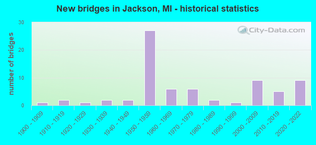
- New bridges - historical statistics
- 11900-1909
- 21910-1919
- 11920-1929
- 21930-1939
- 21940-1949
- 271950-1959
- 61960-1969
- 61970-1979
- 21980-1989
- 11990-1999
- 92000-2009
- 52010-2019
- 92020-2022
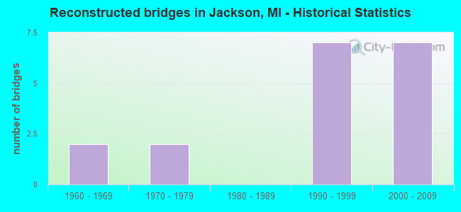
- Reconstructed bridges - Historical Statistics
- 21960-1969
- 21970-1979
- 01980-1989
- 71990-1999
- 72000-2009
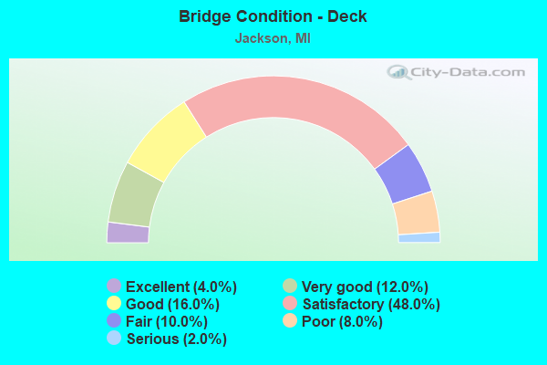
- Bridge Condition - Deck
- 4.0%Excellent
- 12.0%Very good
- 16.0%Good
- 48.0%Satisfactory
- 10.0%Fair
- 8.0%Poor
- 2.0%Serious
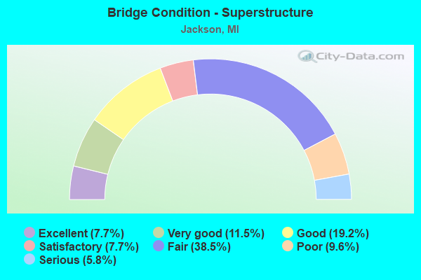
- Bridge Condition - Superstructure
- 7.7%Excellent
- 11.5%Very good
- 19.2%Good
- 7.7%Satisfactory
- 38.5%Fair
- 9.6%Poor
- 5.8%Serious
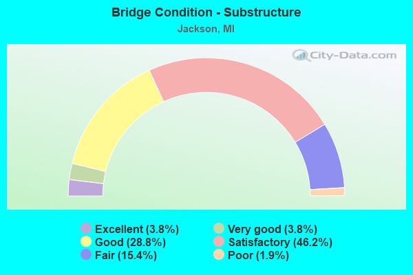
- Bridge Condition - Substructure
- 3.8%Excellent
- 3.8%Very good
- 28.8%Good
- 46.2%Satisfactory
- 15.4%Fair
- 1.9%Poor
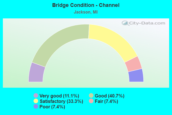
- Bridge Condition - Channel
- 11.1%Very good
- 40.7%Good
- 33.3%Satisfactory
- 7.4%Fair
- 7.4%Poor
Find on map >> Show street view
Structure Number: 454, Location: 200 FT.EAST OF JACKSON ST (Lat: 42.252300, Lng: -84.407903), Route carried "on" structure: City street , Year Built: 1970, Status: Open, Structure Length: 1.23m (4.04ft), Average Daily Traffic: 86 (year 2020), Truck Traffic: 3%, Average Future Daily Traffic: 128 (year 2040), Design Load: HS 20, Features Intersected: GRAND RIVER, Facility Carried by Structure: TRAIL STREET
Minimum Vertical Clearance: 30.48m (100.00ft), Kilometerpoint: 0.898, Lanes on structure: 2, Owner: City or Municipal Highway Agency, Approaching Roadway Width: 11.0m (36.1ft), Skew: 2 degrees, Material/Design: Prestressed concrete, Design/Construction: Box Beam or Girders - Single/Spread, Number Of Spans In Main Unit: 1, Length of Maximum Span: 12.0m (39.4ft), Curb or Sidewalk Widths: Left: 2.0m (6.6ft), Right: 2.0m (6.6ft), Curb-To-Curb Width: 12.2m (40.0ft), Out-to-Out Width: 15.8m (51.8ft)
Condition: Deck: Fair, Superstructure: Good, Substructure: Fair, Channel: Satisfactory, Operating Rating: 63.4 metric tons, Method Used To Determine Operating Rating: Load Factor (LF), Inventory Rating: 38.0 metric tons, Method Used To Determine Inventory Rating: Load Factor (LF), Structural Evaluation: Somewhat better than minimum adequacy, Deck Geometry: Superior to present desirable criteria, Waterway Adequacy: Equal to present desirable criteria, Approach Roadway Alignment: Equal to present desirable criteria, Designated Inspection Frequency: Every 24 months, Inspection Date: October 2020, Deck Structure Type: Concrete Cast-file-Place, Wearing Surface/Protective System: Wearing Surface: Monolithic Concrete
Find on map >> Show street view
Structure Number: 4541, Location: 400 FT E OF N JACKSON ST (Lat: 42.254686, Lng: -84.407358), Route carried "on" structure: Business City street 2009, Year Built: 1956, Status: Posted for load, Structure Length: 1.20m (3.94ft), Average Daily Traffic: 11,402 (year 2010), Truck Traffic: 3%, Average Future Daily Traffic: 15,357 (year 2030), Design Load: HS 20, Features Intersected: GRAND RIVER, Facility Carried by Structure: EAST GANSON STREET
Minimum Vertical Clearance: 30.48m (100.00ft), Kilometerpoint: 2.549, Lanes on structure: 3, Owner: City or Municipal Highway Agency, Approaching Roadway Width: 14.0m (45.9ft), Material/Design: Prestressed concrete, Design/Construction: Box Beam or Girders - Multiple, Number Of Spans In Main Unit: 1, Length of Maximum Span: 12.0m (39.4ft), Curb or Sidewalk Widths: Left: 2.0m (6.6ft), Right: 2.0m (6.6ft), Curb-To-Curb Width: 14.0m (45.9ft), Out-to-Out Width: 20.0m (65.6ft)
Condition: Deck: Poor, Superstructure: Serious, Substructure: Satisfactory, Channel: Satisfactory, Operating Rating: 37.9 metric tons, Method Used To Determine Operating Rating: Load Factor (LF) rating reported by rating factor (RF) method using MS18 loading, Inventory Rating: 22.7 metric tons, Method Used To Determine Inventory Rating: Load Factor (LF) rating reported by rating factor (RF) method using MS18 loading, Structural Evaluation: High priority of corrective action, Deck Geometry: Somewhat better than minimum adequacy, Waterway Adequacy: Equal to present desirable criteria, Approach Roadway Alignment: Equal to present desirable criteria, Bridge Posting: Required (Relationship of Operating Rating to Maximum Legal Load: 20.0 - 29.9% below), Length Of Structure Improvement: 1.80m (5.91ft), Designated Inspection Frequency: Every 12 months, Inspection Date: October 2021, Bridge Improvement Cost: $260,000, Roadway Improvement Cost: $32,000, Total Project Cost: $294,000, Deck Structure Type: Concrete Cast-file-Place, Wearing Surface/Protective System: Wearing Surface: Bituminous
Find on map >> Show street view
Structure Number: 4542, Location: 1200 FT W OF COOPER ST (Lat: 42.258967, Lng: -84.408253), Route carried "on" structure: City street 2009, Year Built: 1989, Status: Open, Structure Length: 1.49m (4.89ft), Average Daily Traffic: 7,591 (year 2020), Truck Traffic: 2%, Average Future Daily Traffic: 11,310 (year 2040), Design Load: HS 20, Features Intersected: GRAND RIVER, Facility Carried by Structure: WEST NORTH STREET
Minimum Vertical Clearance: 30.48m (100.00ft), Kilometerpoint: 2.862, Lanes on structure: 2, Owner: City or Municipal Highway Agency, Approaching Roadway Width: 12.0m (39.4ft), Material/Design: Prestressed concrete, Design/Construction: Box Beam or Girders - Multiple, Number Of Spans In Main Unit: 1, Length of Maximum Span: 14.9m (48.9ft), Curb or Sidewalk Widths: Left: 2.0m (6.6ft), Right: 2.0m (6.6ft), Curb-To-Curb Width: 12.2m (40.0ft), Out-to-Out Width: 16.2m (53.1ft)
Condition: Deck: Satisfactory, Superstructure: Satisfactory, Substructure: Good, Channel: Satisfactory, Operating Rating: 73.9 metric tons, Method Used To Determine Operating Rating: Load Factor (LF) rating reported by rating factor (RF) method using MS18 loading, Inventory Rating: 44.4 metric tons, Method Used To Determine Inventory Rating: Load Factor (LF) rating reported by rating factor (RF) method using MS18 loading, Structural Evaluation: Equal to present minimum criteria, Deck Geometry: Somewhat better than minimum adequacy, Waterway Adequacy: Equal to present desirable criteria, Approach Roadway Alignment: Equal to present desirable criteria, Designated Inspection Frequency: Every 24 months, Inspection Date: October 2020, Deck Structure Type: Concrete Cast-file-Place, Wearing Surface/Protective System: Wearing Surface: Integral Concrete, Deck Protection: Epoxy Coated Reinforcing
Find on map >> Show street view
Structure Number: 4543, Location: 0.3 MI WEST OF COOPER ST (Lat: 42.265069, Lng: -84.409567), Route carried "on" structure: City street 2009, Year Built: 1919, Status: Open, Structure Length: 1.80m (5.91ft), Average Daily Traffic: 4,500 (year 2010), Truck Traffic: 3%, Average Future Daily Traffic: 6,061 (year 2030), Features Intersected: GRAND RIVER, Facility Carried by Structure: MONROE STREET
Minimum Vertical Clearance: 30.48m (100.00ft), Kilometerpoint: 1.543, Lanes on structure: 2, Owner: City or Municipal Highway Agency, Approaching Roadway Width: 13.1m (43.0ft), Material/Design: Concrete, Design/Construction: Arch - Deck, Number Of Spans In Main Unit: 1, Length of Maximum Span: 17.0m (55.8ft), Curb or Sidewalk Widths: Left: 2.0m (6.6ft), Right: 3.0m (9.8ft), Curb-To-Curb Width: 13.1m (43.0ft), Out-to-Out Width: 19.0m (62.3ft)
Condition: Superstructure: Fair, Substructure: Fair, Channel: Fair, Operating Rating: 97.2 metric tons, Method Used To Determine Operating Rating: Load Factor (LF) rating reported by rating factor (RF) method using MS18 loading, Inventory Rating: 81.3 metric tons, Method Used To Determine Inventory Rating: Load Factor (LF) rating reported by rating factor (RF) method using MS18 loading, Structural Evaluation: Somewhat better than minimum adequacy, Deck Geometry: Equal to present minimum criteria, Waterway Adequacy: Equal to present desirable criteria, Approach Roadway Alignment: Equal to present desirable criteria, Length Of Structure Improvement: 2.10m (6.89ft), Designated Inspection Frequency: Every 24 months, Inspection Date: October 2020, Bridge Improvement Cost: $550,000, Roadway Improvement Cost: $50,000, Total Project Cost: $600,000, Wearing Surface/Protective System: Wearing Surface: Bituminous
Find on map >> Show street view
Structure Number: 4544, Location: 100 FT SOUTH OF GLICK HWY (Lat: 42.248867, Lng: -84.405842), Route carried "on" structure: City street , Year Built: 2009, Status: Open, Structure Length: 1.80m (5.91ft), Average Daily Traffic: 4,412 (year 2020), Truck Traffic: 5%, Average Future Daily Traffic: 6,573 (year 2040), Features Intersected: GRAND RIVER, Facility Carried by Structure: MECHANIC STREET
Minimum Vertical Clearance: 30.48m (100.00ft), Kilometerpoint: 0.969, Lanes on structure: 2, Owner: City or Municipal Highway Agency, Approaching Roadway Width: 12.8m (42.0ft), Skew: 3 degrees, Material/Design: Prestressed concrete, Design/Construction: Box Beam or Girders - Single/Spread, Number Of Spans In Main Unit: 1, Length of Maximum Span: 16.6m (54.5ft), Curb or Sidewalk Widths: Left: 3.3m (10.8ft), Right: 3.3m (10.8ft), Curb-To-Curb Width: 12.8m (42.0ft), Out-to-Out Width: 20.4m (66.9ft)
Condition: Deck: Good, Superstructure: Good, Substructure: Good, Channel: Good, Operating Rating: 64.5 metric tons, Method Used To Determine Operating Rating: Load Factor (LF) rating reported by rating factor (RF) method using MS18 loading, Inventory Rating: 38.6 metric tons, Method Used To Determine Inventory Rating: Load Factor (LF) rating reported by rating factor (RF) method using MS18 loading, Structural Evaluation: Better than present minimum criteria, Deck Geometry: Equal to present minimum criteria, Waterway Adequacy: Equal to present desirable criteria, Approach Roadway Alignment: Equal to present desirable criteria, Designated Inspection Frequency: Every 24 months, Inspection Date: October 2020, Deck Structure Type: Concrete Cast-file-Place, Wearing Surface/Protective System: Wearing Surface: Monolithic Concrete, Deck Protection: Epoxy Coated Reinforcing
Find on map >> Show street view
Structure Number: 4545, Location: CBD CONN. TO COOPER ST.BR (Lat: 42.247744, Lng: -84.403461), Route carried "on" structure: City street , Year Built: 1903, Year Reconstructed: 1967, Status: Open, Structure Length: 1.30m (4.27ft), Average Daily Traffic: 6,343 (year 2010), Truck Traffic: 2%, Average Future Daily Traffic: 8,543 (year 2030), Features Intersected: GRAND RIVER, Facility Carried by Structure: FRANCIS STREET
Minimum Vertical Clearance: 30.48m (100.00ft), Kilometerpoint: 5.844, Lanes on structure: 3, Base Highway Network: Yes (Inventory Route: 338, Subroute: 64), Owner: City or Municipal Highway Agency, Approaching Roadway Width: 13.1m (43.0ft), Skew: 2 degrees, Material/Design: Concrete, Design/Construction: Arch - Deck, Number Of Spans In Main Unit: 1, Length of Maximum Span: 12.0m (39.4ft), Curb or Sidewalk Widths: Left: 3.0m (9.8ft), Right: 3.0m (9.8ft), Curb-To-Curb Width: 14.0m (45.9ft), Out-to-Out Width: 20.0m (65.6ft)
Condition: Superstructure: Poor, Substructure: Poor, Channel: Satisfactory, Operating Rating: 32.7 metric tons, Method Used To Determine Operating Rating: Field evaluation and documented engineering judgment, Inventory Rating: 19.6 metric tons, Method Used To Determine Inventory Rating: Field evaluation and documented engineering judgment, Structural Evaluation: Meets minimum limits, Deck Geometry: Somewhat better than minimum adequacy, Waterway Adequacy: Somewhat better than minimum adequacy, Approach Roadway Alignment: Equal to present minimum criteria, Length Of Structure Improvement: 1.50m (4.92ft), Designated Inspection Frequency: Every 12 months, Inspection Date: October 2021, Bridge Improvement Cost: $600,000, Roadway Improvement Cost: $50,000, Total Project Cost: $650,000, Wearing Surface/Protective System: Wearing Surface: Bituminous
Find on map >> Show street view
Structure Number: 4547, Location: 0.1 MI. SOUTH OF HIGH ST. (Lat: 42.232081, Lng: -84.380619), Route carried "on" structure: City street , Year Built: 2005, Status: Open, Structure Length: 1.52m (4.99ft), Average Daily Traffic: 1,087 (year 2010), Truck Traffic: 12%, Average Future Daily Traffic: 1,464 (year 2030), Design Load: HS 20, Features Intersected: GRAND RIVER, Facility Carried by Structure: LOSEY AVENUE
Minimum Vertical Clearance: 30.48m (100.00ft), Kilometerpoint: 0.697, Lanes on structure: 2, Owner: City or Municipal Highway Agency, Approaching Roadway Width: 9.1m (29.9ft), Material/Design: Prestressed concrete, Design/Construction: Box Beam or Girders - Multiple, Number Of Spans In Main Unit: 1, Length of Maximum Span: 14.0m (45.9ft), Curb-To-Curb Width: 9.4m (30.8ft), Out-to-Out Width: 10.5m (34.4ft)
Condition: Deck: Good, Superstructure: Very good, Substructure: Good, Channel: Good, Operating Rating: 97.2 metric tons, Method Used To Determine Operating Rating: Load Factor (LF) rating reported by rating factor (RF) method using MS18 loading, Inventory Rating: 68.0 metric tons, Method Used To Determine Inventory Rating: Load Factor (LF) rating reported by rating factor (RF) method using MS18 loading, Structural Evaluation: Better than present minimum criteria, Deck Geometry: Somewhat better than minimum adequacy, Waterway Adequacy: Equal to present desirable criteria, Approach Roadway Alignment: Equal to present desirable criteria, Designated Inspection Frequency: Every 24 months, Inspection Date: October 2020, Deck Structure Type: Concrete Cast-file-Place, Wearing Surface/Protective System: Wearing Surface: Integral Concrete, Deck Protection: Epoxy Coated Reinforcing
Find on map >> Show street view
Structure Number: 4548, Location: SEWAGE TREATMENT PLANT (Lat: 42.281544, Lng: -84.409203), Route carried "on" structure: Business City street , Year Built: 1934, Year Reconstructed: 1997, Status: Open, Structure Length: 1.50m (4.92ft), Average Daily Traffic: 15 (year 2016), Truck Traffic: 4%, Average Future Daily Traffic: 240 (year 2031), Design Load: HS 20, Features Intersected: GRAND RIVER, Facility Carried by Structure: SEWAGE PLANT DRIVE
Minimum Vertical Clearance: 30.48m (100.00ft), Kilometerpoint: 0.187, Lanes on structure: 2, Owner: City or Municipal Highway Agency, Approaching Roadway Width: 9.1m (29.9ft), Material/Design: Prestressed concrete, Design/Construction: Box Beam or Girders - Multiple, Number Of Spans In Main Unit: 1, Length of Maximum Span: 15.0m (49.2ft), Curb-To-Curb Width: 6.1m (20.0ft), Out-to-Out Width: 8.0m (26.2ft)
Condition: Deck: Good, Superstructure: Good, Substructure: Satisfactory, Channel: Good, Operating Rating: 72.9 metric tons, Method Used To Determine Operating Rating: Load Factor (LF) rating reported by rating factor (RF) method using MS18 loading, Inventory Rating: 43.7 metric tons, Method Used To Determine Inventory Rating: Load Factor (LF) rating reported by rating factor (RF) method using MS18 loading, Structural Evaluation: Equal to present minimum criteria, Deck Geometry: Somewhat better than minimum adequacy, Waterway Adequacy: Equal to present desirable criteria, Approach Roadway Alignment: Equal to present desirable criteria, Designated Inspection Frequency: Every 24 months, Inspection Date: October 2020, Deck Structure Type: Concrete Cast-file-Place, Wearing Surface/Protective System: Wearing Surface: Monolithic Concrete
Find on map >> Show street view
Structure Number: 455, Location: 0.2 MI.EAST OF AIRLINE DR (Lat: 42.236653, Lng: -84.391261), Route carried "on" structure: Business City street , Year Built: 2015, Status: Open, Structure Length: 1.88m (6.17ft), Average Daily Traffic: 1,930 (year 2014), Truck Traffic: 6%, Average Future Daily Traffic: 2,430 (year 2034), Design Load: Greater than HL93, Features Intersected: GRAND RIVER, Facility Carried by Structure: LEWIS STREET
Minimum Vertical Clearance: 30.48m (100.00ft), Kilometerpoint: 0.274, Lanes on structure: 2, Owner: City or Municipal Highway Agency, Approaching Roadway Width: 9.1m (29.9ft), Skew: 1 degrees, Material/Design: Prestressed concrete, Design/Construction: Box Beam or Girders - Single/Spread, Number Of Spans In Main Unit: 1, Length of Maximum Span: 18.0m (59.1ft), Curb or Sidewalk Widths: Left: 1.8m (5.9ft), Right: 0.0m, Curb-To-Curb Width: 9.1m (29.9ft), Out-to-Out Width: 11.9m (39.0ft)
Condition: Deck: Very good, Superstructure: Very good, Substructure: Very good, Channel: Very good, Operating Rating: 59.3 metric tons, Method Used To Determine Operating Rating: Load and Resistance Factor Rating (LRFR) rating reported by rating factor(RF) method using HL-93 loadings, Inventory Rating: 45.7 metric tons, Method Used To Determine Inventory Rating: Load and Resistance Factor Rating (LRFR) rating reported by rating factor(RF) method using HL-93 loadings, Structural Evaluation: Equal to present desirable criteria, Deck Geometry: Somewhat better than minimum adequacy, Waterway Adequacy: Equal to present desirable criteria, Approach Roadway Alignment: Equal to present desirable criteria, Designated Inspection Frequency: Every 24 months, Inspection Date: October 2020, Deck Structure Type: Concrete Cast-file-Place, Wearing Surface/Protective System: Wearing Surface: Monolithic Concrete, Deck Protection: Epoxy Coated Reinforcing
Find on map >> Show street view
Structure Number: 5508, Location: 4.7 MI W OF US-223 (Lat: 41.887119, Lng: -84.154364), Route carried "on" structure: State highway 34, Year Built: 1978, Status: Open, Structure Length: 1.82m (5.97ft), Average Daily Traffic: 5,656 (year 2007), Truck Traffic: 5%, Average Future Daily Traffic: 9,028 (year 2018), Design Load: HS 25 or greater, Features Intersected: HAZEN CREEK
Minimum Vertical Clearance: 30.48m (100.00ft), Kilometerpoint: 20.248, Lanes on structure: 2, Base Highway Network: Yes (Inventory Route: 94, Subroute: 8), Owner: State Highway Agency, Approaching Roadway Width: 10.4m (34.1ft), Skew: 1 degrees, Material/Design: Prestressed concrete, Design/Construction: Stringer/Multi-beam, Number Of Spans In Main Unit: 1, Length of Maximum Span: 18.2m (59.7ft), Curb-To-Curb Width: 14.6m (47.9ft), Out-to-Out Width: 15.1m (49.5ft)
Condition: Deck: Satisfactory, Superstructure: Very good, Substructure: Good, Channel: Fair, Operating Rating: 78.7 metric tons, Method Used To Determine Operating Rating: Load Factor (LF) rating reported by rating factor (RF) method using MS18 loading, Inventory Rating: 47.0 metric tons, Method Used To Determine Inventory Rating: Load Factor (LF) rating reported by rating factor (RF) method using MS18 loading, Structural Evaluation: Better than present minimum criteria, Deck Geometry: Superior to present desirable criteria, Waterway Adequacy: Equal to present desirable criteria, Approach Roadway Alignment: Equal to present desirable criteria, Designated Inspection Frequency: Every 24 months, Inspection Date: June 2020, Deck Structure Type: Concrete Cast-file-Place, Wearing Surface/Protective System: Wearing Surface: Epoxy Overlay
Find on map >> Show street view
Structure Number: 13948, Location: 0.4 MI W OF M-106 (Lat: 42.271611, Lng: -84.408167), Route carried "on" structure: Interstate 94, Year Built: 2019, Status: Open, Structure Length: 22.07m (72.41ft), Average Daily Traffic: 33,550 (year 2014), Truck Traffic: 18%, Average Future Daily Traffic: 38,582 (year 2034), Design Load: Greater than HL93, Features Intersected: CONRAIL & GRAND RIVER
Minimum Vertical Clearance: 30.48m (100.00ft), Kilometerpoint: 0.000, Lanes on structure: 3, Base Highway Network: Yes, Owner: State Highway Agency, Approaching Roadway Width: 21.3m (69.9ft), Material/Design: Prestressed concrete, Design/Construction: Stringer/Multi-beam, Number Of Spans In Main Unit: 6, Length of Maximum Span: 44.9m (147.3ft), Curb-To-Curb Width: 21.3m (69.9ft), Out-to-Out Width: 23.7m (77.8ft)
Condition: Deck: Very good, Superstructure: Very good, Substructure: Good, Channel: Very good, Operating Rating: 63.2 metric tons, Method Used To Determine Operating Rating: Load and Resistance Factor Rating (LRFR) rating reported by rating factor(RF) method using HL-93 loadings, Inventory Rating: 42.8 metric tons, Method Used To Determine Inventory Rating: Load and Resistance Factor Rating (LRFR) rating reported by rating factor(RF) method using HL-93 loadings, Structural Evaluation: Better than present minimum criteria, Deck Geometry: Superior to present desirable criteria, Waterway Adequacy: Equal to present desirable criteria, Approach Roadway Alignment: Equal to present desirable criteria, Designated Inspection Frequency: Every 24 months, Inspection Date: July 2021, Deck Structure Type: Concrete Cast-file-Place, Wearing Surface/Protective System: Wearing Surface: Monolithic Concrete, Deck Protection: Epoxy Coated Reinforcing
Find on map >> Show street view
Structure Number: 13949, Location: 0.4 MI W OF M-106 (Lat: 42.271722, Lng: -84.408167), Route carried "on" structure: Interstate 97, Year Built: 2020, Status: Open, Structure Length: 22.07m (72.41ft), Average Daily Traffic: 33,550 (year 2014), Truck Traffic: 19%, Average Future Daily Traffic: 33,900 (year 2035), Design Load: Greater than HL93, Features Intersected: CONRAIL & GRAND RIVER, Facility Carried by Structure: I-94 WB
Minimum Vertical Clearance: 30.48m (100.00ft), Kilometerpoint: 0.000, Lanes on structure: 3, Base Highway Network: Yes, Owner: State Highway Agency, Approaching Roadway Width: 21.3m (69.9ft), Material/Design: Prestressed concrete, Design/Construction: Stringer/Multi-beam, Number Of Spans In Main Unit: 6, Length of Maximum Span: 44.9m (147.3ft), Curb-To-Curb Width: 21.3m (69.9ft), Out-to-Out Width: 22.3m (73.2ft)
Condition: Deck: Good, Superstructure: Very good, Substructure: Very good, Channel: Very good, Operating Rating: 62.5 metric tons, Method Used To Determine Operating Rating: Load and Resistance Factor Rating (LRFR) rating reported by rating factor(RF) method using HL-93 loadings, Inventory Rating: 38.6 metric tons, Method Used To Determine Inventory Rating: Load and Resistance Factor Rating (LRFR) rating reported by rating factor(RF) method using HL-93 loadings, Structural Evaluation: Equal to present desirable criteria, Deck Geometry: Superior to present desirable criteria, Waterway Adequacy: Equal to present desirable criteria, Approach Roadway Alignment: Equal to present desirable criteria, Designated Inspection Frequency: Every 24 months, Inspection Date: July 2021, Deck Structure Type: Concrete Cast-file-Place, Wearing Surface/Protective System: Wearing Surface: Monolithic Concrete, Deck Protection: Epoxy Coated Reinforcing
Find on map >> Show street view
Structure Number: 1401, Location: @ M-106 (COOPER STREET) (Lat: 42.271778, Lng: -84.403806), Route carried "on" structure: State highway 106, Year Built: 2019, Status: Open, Structure Length: 4.73m (15.52ft), Average Daily Traffic: 7,805 (year 2015), Truck Traffic: 2%, Average Future Daily Traffic: 13,520 (year 2035), Design Load: Greater than HL93, Features Intersected: I-94
Minimum Vertical Clearance: 30.48m (100.00ft), Kilometerpoint: 0.000, Lanes on structure: 2, Lanes under structure: 5, Base Highway Network: Yes (Inventory Route: 90, Subroute: 4), Owner: State Highway Agency, Approaching Roadway Width: 14.6m (47.9ft), Skew: 1 degrees, Material/Design: Prestressed concrete, Design/Construction: Stringer/Multi-beam, Number Of Spans In Main Unit: 2, Length of Maximum Span: 25.7m (84.3ft), Curb or Sidewalk Widths: Left: 3.0m (9.8ft), Right: 0.0m, Curb-To-Curb Width: 14.6m (47.9ft), Out-to-Out Width: 18.7m (61.4ft)
Condition: Deck: Very good, Superstructure: Excellent, Substructure: Good, Operating Rating: 54.1 metric tons, Method Used To Determine Operating Rating: Load and Resistance Factor Rating (LRFR) rating reported by rating factor(RF) method using HL-93 loadings, Inventory Rating: 38.2 metric tons, Method Used To Determine Inventory Rating: Load and Resistance Factor Rating (LRFR) rating reported by rating factor(RF) method using HL-93 loadings, Structural Evaluation: Better than present minimum criteria, Deck Geometry: Superior to present desirable criteria, Approach Roadway Alignment: Equal to present desirable criteria, Designated Inspection Frequency: Every 24 months, Inspection Date: May 2021, Deck Structure Type: Concrete Cast-file-Place, Wearing Surface/Protective System: Wearing Surface: Monolithic Concrete, Deck Protection: Epoxy Coated Reinforcing
Find on map >> Show street view
Structure Number: 145, Location: @ US-127 & M-50 (Lat: 42.272367, Lng: -84.427322), Route carried "on" structure: Interstate 94, Year Built: 2021, Status: Open, Structure Length: 6.13m (20.11ft), Average Daily Traffic: 32,800 (year 2014), Truck Traffic: 18%, Average Future Daily Traffic: 37,720 (year 2034), Design Load: Greater than HL93, Features Intersected: US-127
Minimum Vertical Clearance: 30.48m (100.00ft), Kilometerpoint: 24.169, Lanes on structure: 3, Lanes under structure: 4, Base Highway Network: Yes (Inventory Route: 89, Subroute: 9), Owner: State Highway Agency, Approaching Roadway Width: 19.7m (64.6ft), Skew: 1 degrees, Material/Design: Prestressed concrete, Design/Construction: Stringer/Multi-beam, Number Of Spans In Main Unit: 2, Length of Maximum Span: 31.0m (101.7ft), Curb-To-Curb Width: 19.7m (64.6ft), Out-to-Out Width: 20.7m (67.9ft)
Condition: Deck: Excellent, Superstructure: Excellent, Substructure: Good, Operating Rating: 66.4 metric tons, Method Used To Determine Operating Rating: Load and Resistance Factor Rating (LRFR) rating reported by rating factor(RF) method using HL-93 loadings, Inventory Rating: 46.0 metric tons, Method Used To Determine Inventory Rating: Load and Resistance Factor Rating (LRFR) rating reported by rating factor(RF) method using HL-93 loadings, Structural Evaluation: Better than present minimum criteria, Deck Geometry: Superior to present desirable criteria, Approach Roadway Alignment: Equal to present desirable criteria, Designated Inspection Frequency: Every 16 months, Inspection Date: January 2022, Deck Structure Type: Concrete Cast-file-Place, Wearing Surface/Protective System: Wearing Surface: Monolithic Concrete, Deck Protection: Epoxy Coated Reinforcing
Find on map >> Show street view
Structure Number: 4393, Location: @ I-94 BL (MICHIGAN AV) (Lat: 42.254889, Lng: -84.476061), Route carried "under" structure: Business Interstate 94, Year Built: 1958, Structure Length: 0. m, Average Daily Traffic: 12,475 (year 2007), Truck Traffic: 3%, Features Intersected: MDOT RR COR & I-94 BL, Facility Carried by Structure: M-60 EB
Minimum Vertical Clearance: 7.06m (23.16ft), Kilometerpoint: 19.720, Lanes on structure: 3, Lanes under structure: 2, Material/Design: Steel, Design/Construction: Stringer/Multi-beam, Length of Maximum Span: 21.2m (69.6ft)
Find on map >> Show street view
Structure Number: 4394, Location: @ I-94 BL (Lat: 42.254869, Lng: -84.476439), Route carried "under" structure: Business Interstate 94, Year Built: 1958, Structure Length: 0. m, Average Daily Traffic: 12,475 (year 2007), Truck Traffic: 3%, Features Intersected: MDOT RR COR & I-94 BL, Facility Carried by Structure: M-60 WB
Minimum Vertical Clearance: 7.21m (23.65ft), Kilometerpoint: 19.689, Lanes on structure: 2, Lanes under structure: 3, Material/Design: Steel, Design/Construction: Stringer/Multi-beam, Length of Maximum Span: 21.2m (69.6ft)
Find on map >> Show street view
Structure Number: 4395, Location: 2.5 MI S OF I-94 (Lat: 42.232814, Lng: -84.474839), Route carried "under" structure: State highway 60, Year Built: 1958, Structure Length: 0. m, Average Daily Traffic: 10,540 (year 2007), Truck Traffic: 10%, Features Intersected: M-60, Facility Carried by Structure: MCCAIN RD
Minimum Vertical Clearance: 5.31m (17.42ft), Kilometerpoint: 1.027, Lanes on structure: 2, Lanes under structure: 4, Material/Design: Concrete continuous, Design/Construction: Tee Beam, Length of Maximum Span: 21.6m (70.9ft)
Find on map >> Show street view
Structure Number: 4396, Location: @ I-94 (Lat: 42.268928, Lng: -84.476867), Route carried "under" structure: Interstate 94, Year Built: 2020, Structure Length: 0. m, Average Daily Traffic: 45,750 (year 2020), Truck Traffic: 22%, Features Intersected: I-94
Minimum Vertical Clearance: 4.60m (15.09ft), Kilometerpoint: 20.002, Lanes on structure: 1, Lanes under structure: 5, Material/Design: Prestressed concrete, Design/Construction: Stringer/Multi-beam, Length of Maximum Span: 24.8m (81.4ft)
Find on map >> Show street view
Structure Number: 4397, Location: @ I-94 (Lat: 42.268928, Lng: -84.477239), Route carried "under" structure: Interstate 94, Year Built: 2020, Structure Length: 0. m, Average Daily Traffic: 45,750 (year 2020), Truck Traffic: 22%, Features Intersected: I-94
Minimum Vertical Clearance: 4.50m (14.76ft), Kilometerpoint: 19.971, Lanes on structure: 2, Lanes under structure: 4, Material/Design: Prestressed concrete, Design/Construction: Stringer/Multi-beam, Length of Maximum Span: 24.8m (81.4ft)
Find on map >> Show street view
Structure Number: 4415, Location: 0.5 MI W OF M-60 (Lat: 42.268914, Lng: -84.483167), Route carried "under" structure: Interstate 94, Year Built: 1958, Structure Length: 0. m, Average Daily Traffic: 34,202 (year 2014), Truck Traffic: 21%, Features Intersected: I-94, Facility Carried by Structure: BLACKMAN RD
Minimum Vertical Clearance: 4.42m (14.50ft), Kilometerpoint: 19.482, Lanes on structure: 2, Lanes under structure: 4, Material/Design: Steel, Design/Construction: Stringer/Multi-beam, Length of Maximum Span: 14.8m (48.6ft)
Find on map >> Show street view
Structure Number: 4416, Location: 1.1 MI E OF M-60 (Lat: 42.269075, Lng: -84.452836), Route carried "under" structure: Interstate 94, Year Built: 1958, Structure Length: 0. m, Average Daily Traffic: 46,387 (year 2014), Truck Traffic: 20%, Features Intersected: I-94, Facility Carried by Structure: AIRPORT RD
Minimum Vertical Clearance: 4.47m (14.67ft), Kilometerpoint: 21.983, Lanes on structure: 4, Lanes under structure: 4, Material/Design: Steel, Design/Construction: Stringer/Multi-beam, Length of Maximum Span: 14.9m (48.9ft)
Find on map >> Show street view
Structure Number: 4418, Location: 0.6 MI E OF M-50 (Lat: 42.272253, Lng: -84.415039), Route carried "under" structure: Interstate 94, Year Built: 2021, Structure Length: 0. m, Average Daily Traffic: 67,072 (year 2014), Truck Traffic: 18%, Features Intersected: I-94, Facility Carried by Structure: LANSING AVE
Minimum Vertical Clearance: 4.47m (14.67ft), Kilometerpoint: 25.158, Lanes on structure: 3, Lanes under structure: 7, Material/Design: Prestressed concrete, Design/Construction: Stringer/Multi-beam, Length of Maximum Span: 24.0m (78.7ft)
Find on map >> Show street view
Structure Number: 442, Location: 1.0 MI E OF M-106 (Lat: 42.275281, Lng: -84.384350), Route carried "under" structure: Interstate 94, Year Built: 1949, Structure Length: 0. m, Average Daily Traffic: 64,200 (year 2007), Truck Traffic: 17%, Features Intersected: I-94, Facility Carried by Structure: ELM RD
Minimum Vertical Clearance: 4.32m (14.17ft), Kilometerpoint: 27.744, Lanes on structure: 2, Lanes under structure: 4, Material/Design: Steel continuous, Design/Construction: Stringer/Multi-beam, Length of Maximum Span: 24.6m (80.7ft)
Find on map >> Show street view
Structure Number: 4421, Location: 0.2 MI W OF E JCT US-127 (Lat: 42.276886, Lng: -84.364911), Route carried "under" structure: Interstate 94, Year Built: 2009, Structure Length: 0. m, Average Daily Traffic: 64,200 (year 2007), Truck Traffic: 17%, Features Intersected: I-94, Facility Carried by Structure: DETTMAN RD
Minimum Vertical Clearance: 5.51m (18.08ft), Kilometerpoint: 29.357, Lanes on structure: 2, Lanes under structure: 5, Material/Design: Steel continuous, Design/Construction: Stringer/Multi-beam, Length of Maximum Span: 51.8m (169.9ft)
Find on map >> Show street view
Structure Number: 4447, Location: 2.8 MI S OF I-94 BL (Lat: 42.222214, Lng: -84.362378), Route carried "under" structure: US 127, Year Built: 2001, Structure Length: 0. m, Average Daily Traffic: 24,620 (year 2007), Truck Traffic: 10%, Features Intersected: US-127, Facility Carried by Structure: E SOUTH ST
Minimum Vertical Clearance: 5.00m (16.40ft), Kilometerpoint: 3.628, Lanes on structure: 3, Lanes under structure: 4, Material/Design: Prestressed concrete, Design/Construction: Stringer/Multi-beam, Length of Maximum Span: 32.7m (107.3ft)
Find on map >> Show street view
Structure Number: 4451, Location: @ E JCT I-94 (Lat: 42.277033, Lng: -84.358642), Route carried "under" structure: Interstate 94, Year Built: 1958, Structure Length: 0. m, Average Daily Traffic: 63,900 (year 2014), Truck Traffic: 18%, Features Intersected: I-94, Facility Carried by Structure: US-127 NB
Minimum Vertical Clearance: 4.55m (14.93ft), Kilometerpoint: 29.874, Lanes on structure: 1, Lanes under structure: 4, Material/Design: Steel, Design/Construction: Stringer/Multi-beam, Length of Maximum Span: 14.8m (48.6ft)
Find on map >> Show street view
Structure Number: 4452, Location: @ E JCT I-94 (Lat: 42.276883, Lng: -84.358878), Route carried "under" structure: Interstate 94, Year Built: 1958, Structure Length: 0. m, Average Daily Traffic: 63,900 (year 2014), Truck Traffic: 18%, Features Intersected: I-94, Facility Carried by Structure: US-127 SB
Minimum Vertical Clearance: 4.83m (15.85ft), Kilometerpoint: 29.854, Lanes on structure: 2, Lanes under structure: 4, Material/Design: Steel, Design/Construction: Stringer/Multi-beam, Length of Maximum Span: 14.8m (48.6ft)
Find on map >> Show street view
Structure Number: 4458, Location: 1.4 MI N OF I-94 (Lat: 42.291106, Lng: -84.432672), Route carried "under" structure: County highway 2009, Year Built: 1958, Structure Length: 0. m, Average Daily Traffic: 5,440 (year 1995), Truck Traffic: 1%, Features Intersected: PARNALL RD, Facility Carried by Structure: US-127, M-50 NB
Minimum Vertical Clearance: 5.43m (17.81ft), Kilometerpoint: 2.466, Lanes on structure: 3, Lanes under structure: 2, Material/Design: Steel, Design/Construction: Stringer/Multi-beam, Length of Maximum Span: 12.5m (41.0ft)
Find on map >> Show street view
Structure Number: 4459, Location: 1.4 MI N OF I-94 (Lat: 42.291108, Lng: -84.432894), Route carried "under" structure: County highway 2009, Year Built: 1958, Structure Length: 0. m, Average Daily Traffic: 5,440 (year 1995), Truck Traffic: 1%, Features Intersected: PARNALL RD, Facility Carried by Structure: US-127, M-50 SB
Minimum Vertical Clearance: 4.55m (14.93ft), Kilometerpoint: 2.448, Lanes on structure: 3, Lanes under structure: 2, Material/Design: Steel, Design/Construction: Stringer/Multi-beam, Length of Maximum Span: 12.5m (41.0ft)
Find on map >> Show street view
Structure Number: 446, Location: @ M-50 NB 2 MI N OF I-94 (Lat: 42.296661, Lng: -84.432658), Route carried "under" structure: US 127, Year Built: 2005, Structure Length: 0. m, Average Daily Traffic: 20,392 (year 2007), Truck Traffic: 9%, Features Intersected: US-127, Facility Carried by Structure: M-50 NB
Minimum Vertical Clearance: 5.16m (16.93ft), Kilometerpoint: 2.839, Lanes on structure: 1, Lanes under structure: 4, Material/Design: Prestressed concrete, Design/Construction: Stringer/Multi-beam, Length of Maximum Span: 33.8m (110.9ft)
Find on map >> Show street view
Structure Number: 4461, Location: 0.3 MI N OF I-94 (Lat: 42.278583, Lng: -84.431678), Route carried "under" structure: US 127, Year Built: 1971, Structure Length: 0. m, Average Daily Traffic: 29,254 (year 2007), Truck Traffic: 8%, Features Intersected: US-127, Facility Carried by Structure: SPRINGPORT ROAD
Minimum Vertical Clearance: 4.39m (14.40ft), Kilometerpoint: 0.819, Lanes on structure: 4, Lanes under structure: 6, Material/Design: Steel, Design/Construction: Stringer/Multi-beam, Length of Maximum Span: 22.2m (72.8ft)
Find on map >> Show street view
Structure Number: 4462, Location: 4.0 MI N OF I-94 (Lat: 42.327525, Lng: -84.428739), Route carried "under" structure: US 127, Year Built: 1966, Structure Length: 0. m, Average Daily Traffic: 20,392 (year 2007), Truck Traffic: 9%, Features Intersected: US-127, Facility Carried by Structure: VAN HORN RD
Minimum Vertical Clearance: 4.47m (14.67ft), Kilometerpoint: 6.335, Lanes on structure: 2, Lanes under structure: 4, Material/Design: Prestressed concrete, Design/Construction: Stringer/Multi-beam, Length of Maximum Span: 16.4m (53.8ft)
Find on map >> Show street view
Structure Number: 1401, Location: @ M-106 (COOPER STREET) (Lat: 42.271778, Lng: -84.403806), Route carried "under" structure: Interstate 94, Year Built: 2019, Structure Length: 0. m, Average Daily Traffic: 56,475 (year 2015), Truck Traffic: 18%, Features Intersected: I-94, Facility Carried by Structure: M-106
Minimum Vertical Clearance: 5.23m (17.16ft), Kilometerpoint: 0.000, Lanes on structure: 2, Lanes under structure: 5, Material/Design: Prestressed concrete, Design/Construction: Stringer/Multi-beam, Length of Maximum Span: 25.7m (84.3ft)
Find on map >> Show street view
Structure Number: 145, Location: @ US-127 & M-50 (Lat: 42.272367, Lng: -84.427322), Route carried "under" structure: US 127, Year Built: 2021, Structure Length: 0. m, Average Daily Traffic: 13,700 (year 2014), Truck Traffic: 6%, Features Intersected: US-127, Facility Carried by Structure: I-94 WB
Minimum Vertical Clearance: 30+ m (98+ ft), Kilometerpoint: 0.013, Lanes on structure: 3, Lanes under structure: 4, Material/Design: Prestressed concrete, Design/Construction: Stringer/Multi-beam, Length of Maximum Span: 31.0m (101.7ft)