Bridge Statistics for Jerome, Idaho (ID)
Condition, Traffic, Stress, Structural Evaluation, Project Costs
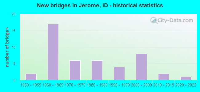
- New bridges - historical statistics
- 21950-1959
- 171960-1969
- 61970-1979
- 61980-1989
- 41990-1999
- 82000-2009
- 22010-2019
- 12020-2022
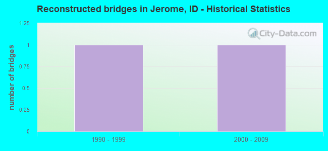
- Reconstructed bridges - Historical Statistics
- 11990-1999
- 12000-2009
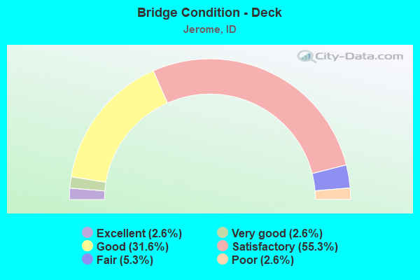
- Bridge Condition - Deck
- 2.6%Excellent
- 2.6%Very good
- 31.6%Good
- 55.3%Satisfactory
- 5.3%Fair
- 2.6%Poor
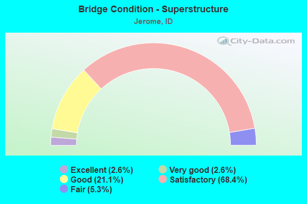
- Bridge Condition - Superstructure
- 2.6%Excellent
- 2.6%Very good
- 21.1%Good
- 68.4%Satisfactory
- 5.3%Fair
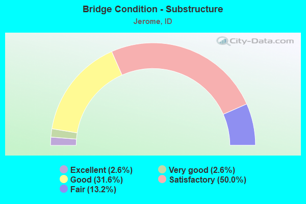
- Bridge Condition - Substructure
- 2.6%Excellent
- 2.6%Very good
- 31.6%Good
- 50.0%Satisfactory
- 13.2%Fair

- Bridge Condition - Channel
- 3.1%Excellent
- 43.8%Very good
- 40.6%Good
- 6.3%Satisfactory
- 6.3%Fair
Find on map >> Show street view
Structure Number: 1531, Location: 2.8 E. JEROME (Lat: 42.688333, Lng: -114.518472), Route carried "under" structure: Interstate 84, Year Built: 1966, Structure Length: 0. m, Average Daily Traffic: 27,000 (year 2018), Truck Traffic: 25%, Features Intersected: I 84 EB-WB;S.JEROME IC, Facility Carried by Structure: SH 79
Minimum Vertical Clearance: 5.30m (17.39ft), Kilometerpoint: 270.371, Lanes on structure: 4, Lanes under structure: 4, Material/Design: Steel, Design/Construction: Stringer/Multi-beam, Length of Maximum Span: 32.0m (105.0ft)
Find on map >> Show street view
Structure Number: 1617, Location: 4.9 E. JEROME (Lat: 42.666089, Lng: -114.493050), Route carried "under" structure: County highway 2763, Year Built: 1965, Structure Length: 0. m, Average Daily Traffic: 1,100 (year 2018), Truck Traffic: 16%, Features Intersected: 400 SOUTH RD GS 2, Facility Carried by Structure: I 84 EBL
Minimum Vertical Clearance: 4.42m (14.50ft), Kilometerpoint: 172.258, Lanes on structure: 2, Lanes under structure: 2, Material/Design: Prestressed concrete, Design/Construction: Stringer/Multi-beam, Length of Maximum Span: 16.2m (53.1ft)
Find on map >> Show street view
Structure Number: 16175, Location: 4.9 E. JEROME (Lat: 42.665819, Lng: -114.492169), Route carried "under" structure: County highway 2763, Year Built: 1965, Structure Length: 0. m, Average Daily Traffic: 1,100 (year 2018), Truck Traffic: 16%, Features Intersected: 400 SOUTH RD GS 2, Facility Carried by Structure: I 84 WBL
Minimum Vertical Clearance: 4.50m (14.76ft), Kilometerpoint: 172.271, Lanes on structure: 2, Lanes under structure: 2, Material/Design: Prestressed concrete, Design/Construction: Stringer/Multi-beam, Length of Maximum Span: 16.2m (53.1ft)
Find on map >> Show street view
Structure Number: 16186, Location: 3.6 N. TWIN FALLS (Lat: 42.642369, Lng: -114.445397), Route carried "under" structure: Alternate US 93, Year Built: 2003, Structure Length: 0. m, Average Daily Traffic: 19,000 (year 2018), Truck Traffic: 12%, Features Intersected: US 93;W.TWIN FALLS IC, Facility Carried by Structure: I 84 WBL
Minimum Vertical Clearance: 5.54m (18.18ft), Kilometerpoint: 85.442, Lanes on structure: 3, Lanes under structure: 4, Material/Design: Prestressed concrete, Design/Construction: Stringer/Multi-beam, Length of Maximum Span: 23.8m (78.1ft)
Find on map >> Show street view
Structure Number: 24835, Location: 1.7 W. JEROME (Lat: 42.733694, Lng: -114.577333), Route carried "under" structure: Interstate 84, Year Built: 1971, Structure Length: 0. m, Average Daily Traffic: 22,500 (year 2018), Truck Traffic: 27%, Features Intersected: I 84 EB-WB;GS NO.3, Facility Carried by Structure: N 300 W
Minimum Vertical Clearance: 7.24m (23.75ft), Kilometerpoint: 262.991, Lanes on structure: 2, Lanes under structure: 4, Material/Design: Steel continuous, Design/Construction: Girder and Floorbeam System, Length of Maximum Span: 38.1m (125.0ft)
Find on map >> Show street view
Structure Number: 2484, Location: 1.2 E. JEROME (Lat: 42.709669, Lng: -114.534006), Route carried "under" structure: Interstate 84, Year Built: 1965, Structure Length: 0. m, Average Daily Traffic: 23,000 (year 2018), Truck Traffic: 27%, Features Intersected: I 84;100 SOUTH RD GS 1, Facility Carried by Structure: 100 SOUTH ROAD
Minimum Vertical Clearance: 5.33m (17.49ft), Kilometerpoint: 267.727, Lanes on structure: 2, Lanes under structure: 4, Material/Design: Prestressed concrete, Design/Construction: Stringer/Multi-beam, Length of Maximum Span: 17.1m (56.1ft)