Bridge Statistics for Johnstown, Pennsylvania (PA)
Condition, Traffic, Stress, Structural Evaluation, Project Costs
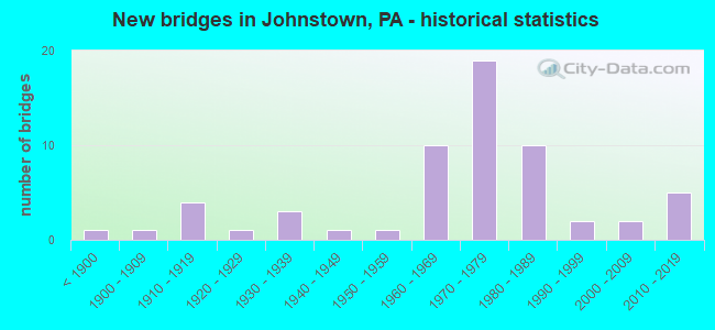
- New bridges - historical statistics
- 1Before 1900
- 11900-1909
- 41910-1919
- 11920-1929
- 31930-1939
- 11940-1949
- 11950-1959
- 101960-1969
- 191970-1979
- 101980-1989
- 21990-1999
- 22000-2009
- 52010-2019

- Reconstructed bridges - Historical Statistics
- 21970-1979
- 51980-1989
- 41990-1999
- 72000-2009
- 62010-2019


- Bridge Condition - Deck
- 7.7%Excellent
- 20.5%Very good
- 33.3%Good
- 17.9%Satisfactory
- 15.4%Fair
- 5.1%Poor

- Bridge Condition - Superstructure
- 25.6%Very good
- 33.3%Good
- 20.5%Satisfactory
- 17.9%Fair
- 2.6%Poor

- Bridge Condition - Substructure
- 12.8%Very good
- 38.5%Good
- 30.8%Satisfactory
- 12.8%Fair
- 2.6%Poor
- 2.6%Serious

- Bridge Condition - Channel
- 41.2%Very good
- 38.2%Good
- 8.8%Satisfactory
- 5.9%Fair
- 5.9%Poor

- Bridge Condition - Culverts
- 25.0%Very good
- 25.0%Good
- 50.0%Satisfactory
Find on map >> Show street view
Structure Number: 47591, Location: 0.13 MILE SOUTH OF PA 56 (Lat: 40.322681, Lng: -78.921328), Route carried "on" structure: State highway 403, Year Built: 2012, Status: Open, Structure Length: 6.95m (22.80ft), Average Daily Traffic: 5,865 (year 2022), Truck Traffic: 5%, Average Future Daily Traffic: 9,027 (year 2032), Design Load: HL 93, Features Intersected: STONYCREEK RIVER
Minimum Vertical Clearance: 30+ m (98+ ft), Kilometerpoint: 6.973, Lanes on structure: 3, Base Highway Network: Yes, Owner: State Highway Agency, Approaching Roadway Width: 11.3m (37.1ft), Material/Design: Steel continuous, Design/Construction: Stringer/Multi-beam, Number Of Spans In Main Unit: 2, Length of Maximum Span: 34.4m (112.9ft), Curb or Sidewalk Widths: Left: 2.4m (7.9ft), Right: 2.0m (6.6ft), Curb-To-Curb Width: 11.3m (37.1ft), Out-to-Out Width: 16.9m (55.4ft)
Condition: Deck: Very good, Superstructure: Very good, Substructure: Very good, Channel: Good, Operating Rating: 48.6 metric tons, Method Used To Determine Operating Rating: Assigned ratings based on Load and Resistance Factor Design (LRFD) reported by rating factor (RF) using HL93 loadings, Inventory Rating: 37.6 metric tons, Method Used To Determine Inventory Rating: Assigned ratings based on Load and Resistance Factor Design (LRFD) reported by rating factor (RF) using HL93 loadings, Structural Evaluation: Equal to present desirable criteria, Deck Geometry: High priority of replacement, Waterway Adequacy: Equal to present desirable criteria, Approach Roadway Alignment: Equal to present desirable criteria, Designated Inspection Frequency: Every 48 months, Inspection Date: October 2018, Deck Structure Type: Concrete Cast-file-Place, Wearing Surface/Protective System: Wearing Surface: Epoxy Overlay, Deck Protection: Galvanized Reinforcing
Find on map >> Show street view
Structure Number: 52784, Location: 200' W of Bedford Street (Lat: 40.322144, Lng: -78.916303), Route carried "on" structure: City street , Year Built: 2015, Status: Open, Structure Length: 7.07m (23.20ft), Average Daily Traffic: 9,012 (year 2021), Truck Traffic: 7%, Average Future Daily Traffic: 9,013 (year 2041), Design Load: HL 93, Features Intersected: Stonycreek River, Facility Carried by Structure: Haynes Street
Minimum Vertical Clearance: 30+ m (98+ ft), Kilometerpoint: 0.000, Lanes on structure: 3, Base Highway Network: Yes, Owner: City or Municipal Highway Agency, Approaching Roadway Width: 11.3m (37.1ft), Material/Design: Steel continuous, Design/Construction: Stringer/Multi-beam, Number Of Spans In Main Unit: 2, Length of Maximum Span: 35.1m (115.2ft), Curb or Sidewalk Widths: Left: 2.0m (6.6ft), Right: 2.0m (6.6ft), Curb-To-Curb Width: 11.3m (37.1ft), Out-to-Out Width: 16.5m (54.1ft)
Condition: Deck: Good, Superstructure: Very good, Substructure: Good, Channel: Poor, Operating Rating: 48.0 metric tons, Method Used To Determine Operating Rating: Assigned ratings based on Load and Resistance Factor Design (LRFD) reported by rating factor (RF) using HL93 loadings, Inventory Rating: 36.6 metric tons, Method Used To Determine Inventory Rating: Assigned ratings based on Load and Resistance Factor Design (LRFD) reported by rating factor (RF) using HL93 loadings, Structural Evaluation: Better than present minimum criteria, Deck Geometry: High priority of replacement, Waterway Adequacy: Superior to present desirable criteria, Approach Roadway Alignment: Better than present minimum criteria, Designated Inspection Frequency: Every 24 months, Inspection Date: December 2019, Deck Structure Type: Concrete Cast-file-Place, Wearing Surface/Protective System: Wearing Surface: Monolithic Concrete, Membrane: Other, Deck Protection: Galvanized Reinforcing
Find on map >> Show street view
Structure Number: 5281, Location: JOHNSTOWN (Lat: 40.303225, Lng: -78.922814), Route carried "on" structure: State highway , Year Built: 2015, Status: Open, Structure Length: 1.07m (3.51ft), Average Daily Traffic: 5,610 (year 2020), Truck Traffic: 3%, Average Future Daily Traffic: 8,036 (year 2034), Design Load: HL 93, Features Intersected: CHENEY RUN, Facility Carried by Structure: SOUTHMONT BLVD
Minimum Vertical Clearance: 30+ m (98+ ft), Kilometerpoint: 1.775, Lanes on structure: 2, Owner: State Highway Agency, Approaching Roadway Width: 15.5m (50.9ft), Skew: 6 degrees, Material/Design: Concrete, Design/Construction: Culvert, Number Of Spans In Main Unit: 1, Length of Maximum Span: 4.3m (14.1ft), Curb or Sidewalk Widths: Left: 2.1m (6.9ft), Right: 0.0m
Condition: Channel: Very good, Culverts: Very good, Operating Rating: 48.3 metric tons, Method Used To Determine Operating Rating: Assigned ratings based on Load and Resistance Factor Design (LRFD) reported by rating factor (RF) using HL93 loadings, Inventory Rating: 36.9 metric tons, Method Used To Determine Inventory Rating: Assigned ratings based on Load and Resistance Factor Design (LRFD) reported by rating factor (RF) using HL93 loadings, Structural Evaluation: Equal to present desirable criteria, Waterway Adequacy: Equal to present desirable criteria, Approach Roadway Alignment: Equal to present desirable criteria, Designated Inspection Frequency: Every 48 months, Inspection Date: June 2019
Find on map >> Show street view
Structure Number: 53686, Location: 3 MI N OF JOHNSTOWN (Lat: 40.367753, Lng: -78.935556), Route carried "on" structure: State highway , Year Built: 2016, Status: Open, Structure Length: 2.13m (6.99ft), Average Daily Traffic: 1,912 (year 2020), Truck Traffic: 3%, Average Future Daily Traffic: 3,280 (year 2036), Design Load: HL 93, Features Intersected: LAUREL RUN, Facility Carried by Structure: SR 3041
Minimum Vertical Clearance: 30+ m (98+ ft), Kilometerpoint: 0.000, Lanes on structure: 2, Owner: State Highway Agency, Approaching Roadway Width: 11.6m (38.1ft), Skew: 4 degrees, Material/Design: Prestressed concrete, Design/Construction: Box Beam or Girders - Single/Spread, Number Of Spans In Main Unit: 1, Length of Maximum Span: 20.7m (67.9ft), Curb or Sidewalk Widths: Left: 1.6m (5.2ft), Right: 0.2m (0.7ft), Curb-To-Curb Width: 11.6m (38.1ft), Out-to-Out Width: 14.0m (45.9ft)
Condition: Deck: Very good, Superstructure: Very good, Substructure: Very good, Channel: Very good, Operating Rating: 46.7 metric tons, Method Used To Determine Operating Rating: Assigned ratings based on Load and Resistance Factor Design (LRFD) reported by rating factor (RF) using HL93 loadings, Inventory Rating: 36.0 metric tons, Method Used To Determine Inventory Rating: Assigned ratings based on Load and Resistance Factor Design (LRFD) reported by rating factor (RF) using HL93 loadings, Structural Evaluation: Equal to present desirable criteria, Deck Geometry: Equal to present minimum criteria, Waterway Adequacy: Equal to present minimum criteria, Approach Roadway Alignment: Equal to present desirable criteria, Designated Inspection Frequency: Every 48 months, Inspection Date: September 2020, Deck Structure Type: Concrete Cast-file-Place, Wearing Surface/Protective System: Wearing Surface: Monolithic Concrete, Deck Protection: Epoxy Coated Reinforcing
Find on map >> Show street view
Structure Number: 56008, Location: 0.1 MILE NORTH OF PA 756 (Lat: 40.301833, Lng: -78.910903), Route carried "on" structure: State highway 403, Year Built: 2018, Status: Open, Structure Length: 7.19m (23.59ft), Average Daily Traffic: 4,783 (year 2022), Truck Traffic: 5%, Average Future Daily Traffic: 5,100 (year 2029), Design Load: HL 93, Features Intersected: STONYCREEK RIVER
Minimum Vertical Clearance: 30+ m (98+ ft), Kilometerpoint: 3.792, Lanes on structure: 4, Base Highway Network: Yes, Owner: State Highway Agency, Approaching Roadway Width: 14.0m (45.9ft), Material/Design: Steel continuous, Design/Construction: Stringer/Multi-beam, Number Of Spans In Main Unit: 2, Length of Maximum Span: 35.7m (117.1ft), Curb or Sidewalk Widths: Left: 2.4m (7.9ft), Right: 2.4m (7.9ft), Curb-To-Curb Width: 14.0m (45.9ft), Out-to-Out Width: 20.0m (65.6ft)
Condition: Deck: Good, Superstructure: Very good, Substructure: Very good, Channel: Very good, Operating Rating: 48.9 metric tons, Method Used To Determine Operating Rating: Assigned ratings based on Load and Resistance Factor Design (LRFD) reported by rating factor (RF) using HL93 loadings, Inventory Rating: 37.6 metric tons, Method Used To Determine Inventory Rating: Assigned ratings based on Load and Resistance Factor Design (LRFD) reported by rating factor (RF) using HL93 loadings, Structural Evaluation: Equal to present desirable criteria, Deck Geometry: High priority of replacement, Waterway Adequacy: Equal to present desirable criteria, Approach Roadway Alignment: Equal to present desirable criteria, Length Of Structure Improvement: 7.20m (23.62ft), Designated Inspection Frequency: Every 48 months, Inspection Date: November 2020, Deck Structure Type: Concrete Cast-file-Place, Wearing Surface/Protective System: Wearing Surface: Monolithic Concrete, Deck Protection: Galvanized Reinforcing
Find on map >> Show street view
Structure Number: 57231, Location: 0.25mile N.E. of Broad St (Lat: 40.340972, Lng: -78.923944), Route carried "on" structure: Business City street , Year Built: 1930, Status: Open, Structure Length: 1.07m (3.51ft), Average Daily Traffic: 100 (year 2021), Truck Traffic: 5%, Average Future Daily Traffic: 101 (year 2041), Design Load: H 10, Features Intersected: Hinckston Run, Facility Carried by Structure: Iron Street
Minimum Vertical Clearance: 30+ m (98+ ft), Kilometerpoint: 0.000, Lanes on structure: 2, Owner: Local Agency, Approaching Roadway Width: 7.3m (24.0ft), Material/Design: Steel, Design/Construction: Stringer/Multi-beam, Number Of Spans In Main Unit: 2, Length of Maximum Span: 10.1m (33.1ft), Curb-To-Curb Width: 13.4m (44.0ft), Out-to-Out Width: 18.0m (59.1ft)
Condition: Deck: Poor, Superstructure: Poor, Substructure: Serious, Channel: Satisfactory, Operating Rating: 49.0 metric tons, Method Used To Determine Operating Rating: Field evaluation and documented engineering judgment, Inventory Rating: 32.7 metric tons, Method Used To Determine Inventory Rating: Field evaluation and documented engineering judgment, Structural Evaluation: High priority of corrective action, Deck Geometry: Superior to present desirable criteria, Waterway Adequacy: Superior to present desirable criteria, Approach Roadway Alignment: Better than present minimum criteria, Designated Inspection Frequency: Every 24 months, Other Special Inspection Frequency: Every 12 months, Inspection Date: October 2021, Other Special Inspection Date: October 2021, Deck Structure Type: Concrete Cast-file-Place, Wearing Surface/Protective System: Wearing Surface: Bituminous
Find on map >> Show street view
Structure Number: 8405, Location: OVER TR 403 & TR 271 (Lat: 40.321111, Lng: -78.922886), Route carried "under" structure: State highway , Year Built: 1972, Structure Length: 0. m, Average Daily Traffic: 1,935 (year 2020), Truck Traffic: 3%, Features Intersected: 403,271,3016,3055,8016,R, Facility Carried by Structure: PA 56
Minimum Vertical Clearance: 5.16m (16.93ft), Kilometerpoint: 0.924, Lanes on structure: 2, Lanes under structure: 2, Material/Design: Steel continuous, Design/Construction: Stringer/Multi-beam, Length of Maximum Span: 48.2m (158.1ft)
Find on map >> Show street view
Structure Number: 8405, Location: OVER TR 403 & TR 271 (Lat: 40.321111, Lng: -78.922886), Route carried "under" structure: State highway , Year Built: 1972, Structure Length: 0. m, Average Daily Traffic: 2,849 (year 2022), Truck Traffic: 7%, Features Intersected: 403,271,3016,3055,8016,R, Facility Carried by Structure: PA 56
Minimum Vertical Clearance: 4.98m (16.34ft), Kilometerpoint: 0.000, Lanes on structure: 2, Lanes under structure: 2, Material/Design: Steel continuous, Design/Construction: Stringer/Multi-beam, Length of Maximum Span: 48.2m (158.1ft)
Find on map >> Show street view
Structure Number: 8405, Location: OVER TR 403 & TR 271 (Lat: 40.321111, Lng: -78.922886), Route carried "under" structure: City street , Year Built: 1972, Structure Length: 0. m, Features Intersected: 403,271,3016,3055,8016,R, Facility Carried by Structure: PA 56
Minimum Vertical Clearance: 8.00m (26.25ft), Kilometerpoint: 0.000, Lanes on structure: 2, Lanes under structure: 2, Material/Design: Steel continuous, Design/Construction: Stringer/Multi-beam, Length of Maximum Span: 48.2m (158.1ft)
Find on map >> Show street view
Structure Number: 8405, Location: OVER TR 403 & TR 271 (Lat: 40.321111, Lng: -78.922886), Route carried "under" structure: City street , Year Built: 1972, Structure Length: 0. m, Features Intersected: 403,271,3016,3055,8016,R, Facility Carried by Structure: PA 56
Minimum Vertical Clearance: 6.77m (22.21ft), Kilometerpoint: 0.000, Lanes on structure: 2, Lanes under structure: 2, Material/Design: Steel continuous, Design/Construction: Stringer/Multi-beam, Length of Maximum Span: 48.2m (158.1ft)
Find on map >> Show street view
Structure Number: 8405, Location: OVER TR 403 & TR 271 (Lat: 40.321111, Lng: -78.922886), Route carried "under" structure: City street , Year Built: 1972, Structure Length: 0. m, Features Intersected: 403,271,3016,3055,8016,R, Facility Carried by Structure: PA 56
Minimum Vertical Clearance: 6.86m (22.51ft), Kilometerpoint: 0.000, Lanes on structure: 2, Lanes under structure: 2, Material/Design: Steel continuous, Design/Construction: Stringer/Multi-beam, Length of Maximum Span: 48.2m (158.1ft)
Find on map >> Show street view
Structure Number: 8405, Location: OVER TR 403 & TR 271 (Lat: 40.321111, Lng: -78.922886), Route carried "under" structure: City street , Year Built: 1972, Structure Length: 0. m, Features Intersected: 403,271,3016,3055,8016,R, Facility Carried by Structure: PA 56
Minimum Vertical Clearance: 4.80m (15.75ft), Kilometerpoint: 0.000, Lanes on structure: 2, Lanes under structure: 2, Material/Design: Steel continuous, Design/Construction: Stringer/Multi-beam, Length of Maximum Span: 48.2m (158.1ft)
Find on map >> Show street view
Structure Number: 8405, Location: OVER TR 403 & TR 271 (Lat: 40.321111, Lng: -78.922886), Route carried "under" structure: Ramp State highway , Year Built: 1972, Structure Length: 0. m, Average Daily Traffic: 4,276 (year 2022), Truck Traffic: 3%, Features Intersected: 403,271,3016,3055,8016,R, Facility Carried by Structure: PA 56
Minimum Vertical Clearance: 5.68m (18.64ft), Kilometerpoint: 0.000, Lanes on structure: 2, Lanes under structure: 1, Material/Design: Steel continuous, Design/Construction: Stringer/Multi-beam, Length of Maximum Span: 48.2m (158.1ft)
Find on map >> Show street view
Structure Number: 8405, Location: OVER TR 403 & TR 271 (Lat: 40.321111, Lng: -78.922886), Route carried "under" structure: State highway , Year Built: 1972, Structure Length: 0. m, Average Daily Traffic: 1,935 (year 2020), Truck Traffic: 3%, Features Intersected: 403,271,3016,3055,8016,R, Facility Carried by Structure: PA 56
Minimum Vertical Clearance: 5.36m (17.59ft), Kilometerpoint: 0.924, Lanes on structure: 2, Lanes under structure: 2, Material/Design: Steel continuous, Design/Construction: Stringer/Multi-beam, Length of Maximum Span: 48.2m (158.1ft)
Find on map >> Show street view
Structure Number: 8405, Location: OVER TR 403 & TR 271 (Lat: 40.321111, Lng: -78.922886), Route carried "under" structure: City street 271, Year Built: 1972, Structure Length: 0. m, Average Daily Traffic: 8,894 (year 2007), Truck Traffic: 7%, Features Intersected: 403,271,3016,3055,8016,R, Facility Carried by Structure: PA 56
Minimum Vertical Clearance: 6.61m (21.69ft), Kilometerpoint: 14.228, Lanes on structure: 2, Lanes under structure: 3, Material/Design: Steel continuous, Design/Construction: Stringer/Multi-beam, Length of Maximum Span: 48.2m (158.1ft)
Find on map >> Show street view
Structure Number: 8405, Location: OVER TR 403 & TR 271 (Lat: 40.321111, Lng: -78.922886), Route carried "under" structure: State highway 403, Year Built: 1972, Structure Length: 0. m, Average Daily Traffic: 8,432 (year 2020), Truck Traffic: 2%, Features Intersected: 403,271,3016,3055,8016,R, Facility Carried by Structure: PA 56
Minimum Vertical Clearance: 6.81m (22.34ft), Kilometerpoint: 6.737, Lanes on structure: 2, Lanes under structure: 2, Material/Design: Steel continuous, Design/Construction: Stringer/Multi-beam, Length of Maximum Span: 48.2m (158.1ft)
Find on map >> Show street view
Structure Number: 8407, Location: OVER BECKLEY AVE. J-TOWN (Lat: 40.312539, Lng: -78.898322), Route carried "under" structure: ServiceCity street , Year Built: 1972, Structure Length: 0. m, Average Daily Traffic: 25 (year 1993), Features Intersected: BECKLEY AVENUE, Facility Carried by Structure: PA 56
Minimum Vertical Clearance: 4.57m (14.99ft), Kilometerpoint: 0.000, Lanes on structure: 4, Lanes under structure: 2, Material/Design: Prestressed concrete, Design/Construction: Box Beam or Girders - Single/Spread, Length of Maximum Span: 21.9m (71.9ft)
Find on map >> Show street view
Structure Number: 841, Location: OVER T-693 AT SR 8020 (Lat: 40.313011, Lng: -78.888372), Route carried "under" structure: City street T693, Year Built: 1964, Structure Length: 0. m, Average Daily Traffic: 25 (year 1993), Features Intersected: WIDMAN STREET (T693), Facility Carried by Structure: PA 56
Minimum Vertical Clearance: 4.44m (14.57ft), Kilometerpoint: 0.000, Lanes on structure: 4, Lanes under structure: 2, Material/Design: Prestressed concrete, Design/Construction: Box Beam or Girders - Single/Spread, Length of Maximum Span: 12.8m (42.0ft)
Find on map >> Show street view
Structure Number: 866, Location: MINERSVILLE-JOHNSTOWN (Lat: 40.341467, Lng: -78.926131), Route carried "under" structure: City street , Year Built: 1914, Structure Length: 0. m, Average Daily Traffic: 50 (year 2004), Features Intersected: LEHIGH VALLEY RR, RIVER, Facility Carried by Structure: SR 3039, 4TH AVE.
Minimum Vertical Clearance: 5.56m (18.24ft), Kilometerpoint: 0.000, Lanes on structure: 2, Lanes under structure: 2, Material/Design: Steel, Design/Construction: Truss - Thru, Length of Maximum Span: 82.0m (269.0ft)
Find on map >> Show street view
Structure Number: 8782, Location: DELLWOOD ST, JOHNSTOWN (Lat: 40.334992, Lng: -78.901978), Route carried "under" structure: City street , Year Built: 1984, Structure Length: 0. m, Average Daily Traffic: 250 (year 2020), Features Intersected: NORFOLK S RR & PLUM AVE, Facility Carried by Structure: DELLWOOD STREET
Minimum Vertical Clearance: 10.55m (34.61ft), Kilometerpoint: 0.000, Lanes on structure: 2, Lanes under structure: 2, Material/Design: Prestressed concrete, Design/Construction: Box Beam or Girders - Multiple, Length of Maximum Span: 33.5m (109.9ft)
Find on map >> Show street view
Structure Number: 8815, Location: BEDFORD ST.EXIT,JOHNSTOWN (Lat: 40.323333, Lng: -78.913333), Route carried "under" structure: State highway , Year Built: 1972, Structure Length: 0. m, Average Daily Traffic: 3,870 (year 2020), Truck Traffic: 3%, Features Intersected: SR 3016 & HORNER ST., Facility Carried by Structure: SR 8016
Minimum Vertical Clearance: 4.95m (16.24ft), Kilometerpoint: 1.188, Lanes on structure: 1, Lanes under structure: 2, Material/Design: Steel, Design/Construction: Stringer/Multi-beam, Length of Maximum Span: 35.7m (117.1ft)
Find on map >> Show street view
Structure Number: 8815, Location: BEDFORD ST.EXIT,JOHNSTOWN (Lat: 40.323333, Lng: -78.913333), Route carried "under" structure: City street , Year Built: 1972, Structure Length: 0. m, Features Intersected: SR 3016 & HORNER ST., Facility Carried by Structure: SR 8016
Minimum Vertical Clearance: 4.82m (15.81ft), Kilometerpoint: 0.000, Lanes on structure: 1, Lanes under structure: 2, Material/Design: Steel, Design/Construction: Stringer/Multi-beam, Length of Maximum Span: 35.7m (117.1ft)
Find on map >> Show street view
Structure Number: 8816, Location: DALE EXIT,JOHNSTOWN (Lat: 40.311778, Lng: -78.895589), Route carried "under" structure: City street , Year Built: 1964, Structure Length: 0. m, Average Daily Traffic: 25 (year 1993), Features Intersected: JACOBY STREET, Facility Carried by Structure: SR 8018
Minimum Vertical Clearance: 4.88m (16.01ft), Kilometerpoint: 0.000, Lanes on structure: 2, Lanes under structure: 2, Material/Design: Prestressed concrete, Design/Construction: Box Beam or Girders - Single/Spread, Length of Maximum Span: 12.8m (42.0ft)