Bridge Statistics for Jonesboro, Arkansas (AR)
Condition, Traffic, Stress, Structural Evaluation, Project Costs
- National Bridge Inventory (NBI) Statistics
- 238Number of bridges
- 2,106ft / 642mTotal length
- $4,030,000Total costs
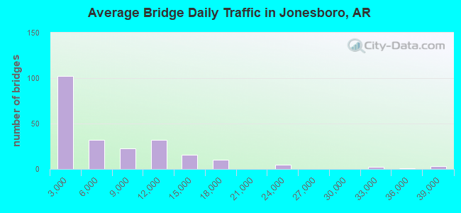
- 1,390,642Total average daily traffic
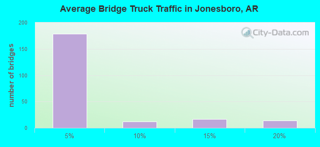
- 56,194Total average daily truck traffic
- National Bridge Inventory (NBI) Registered Bridges for Jonesboro
- No street view available for this location
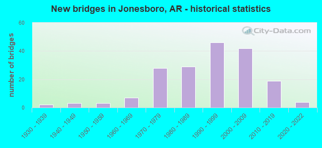
- New bridges - historical statistics
- 21930-1939
- 31940-1949
- 31950-1959
- 71960-1969
- 281970-1979
- 291980-1989
- 461990-1999
- 422000-2009
- 192010-2019
- 42020-2022
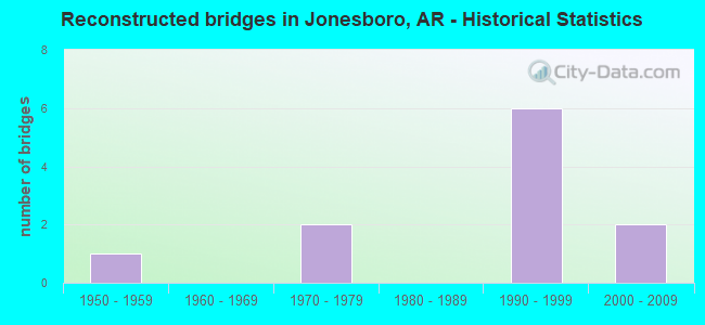
- Reconstructed bridges - Historical Statistics
- 11950-1959
- 01960-1969
- 21970-1979
- 01980-1989
- 61990-1999
- 22000-2009
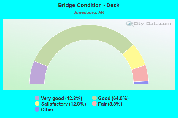
- Bridge Condition - Deck
- 12.8%Very good
- 64.0%Good
- 12.8%Satisfactory
- 8.8%Fair
- 1.6%Poor
- 0.8%Critical
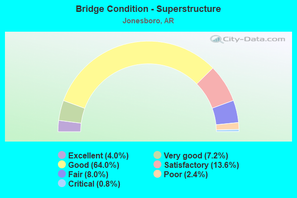
- Bridge Condition - Superstructure
- 4.0%Excellent
- 7.2%Very good
- 64.0%Good
- 13.6%Satisfactory
- 8.0%Fair
- 2.4%Poor
- 0.8%Critical
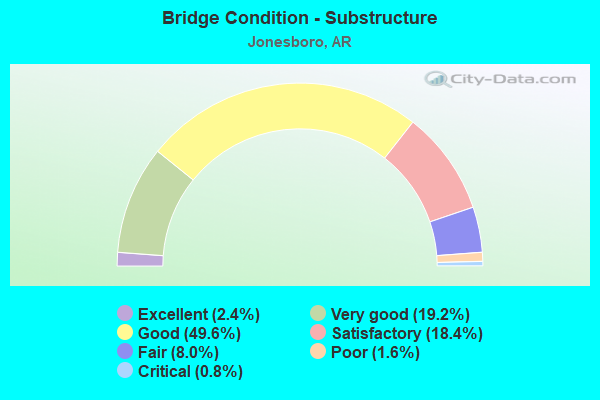
- Bridge Condition - Substructure
- 2.4%Excellent
- 19.2%Very good
- 49.6%Good
- 18.4%Satisfactory
- 8.0%Fair
- 1.6%Poor
- 0.8%Critical
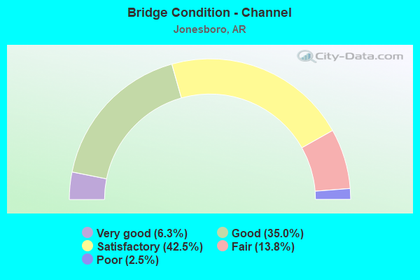
- Bridge Condition - Channel
- 6.3%Very good
- 35.0%Good
- 42.5%Satisfactory
- 13.8%Fair
- 2.5%Poor
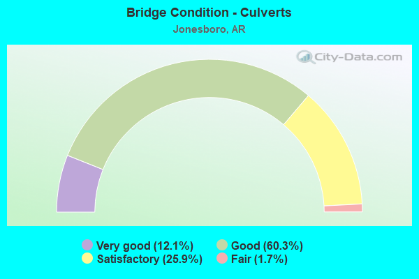
- Bridge Condition - Culverts
- 12.1%Very good
- 60.3%Good
- 25.9%Satisfactory
- 1.7%Fair
Find on map >> Show street view
Structure Number: X1122, Location: 0.15 miles N US HWY 63 (Lat: 35.858447, Lng: -90.775989), Route carried "on" structure: ServiceUS 63, Year Built: 2004, Status: Open, Structure Length: 1.65m (5.41ft), Average Daily Traffic: 116 (year 2014), Truck Traffic: 1%, Average Future Daily Traffic: 2,200 (year 2028), Design Load: H 20, Features Intersected: ROGERS CREEK
Minimum Vertical Clearance: 30+ m (98+ ft), Kilometerpoint: 14.709, Lanes on structure: 2, Base Highway Network: Yes (Inventory Route: 630, Subroute: 1), Owner: State Highway Agency, Approaching Roadway Width: 10.4m (34.1ft), Skew: 4 degrees, Material/Design: Concrete, Design/Construction: Culvert, Number Of Spans In Main Unit: 3, Length of Maximum Span: 5.2m (17.1ft)
Condition: Channel: Good, Culverts: Good, Operating Rating: 32.7 metric tons, Method Used To Determine Operating Rating: Load Factor (LF), Inventory Rating: 20.0 metric tons, Method Used To Determine Inventory Rating: Load Factor (LF), Structural Evaluation: Somewhat better than minimum adequacy, Waterway Adequacy: Equal to present desirable criteria, Approach Roadway Alignment: Equal to present desirable criteria, Designated Inspection Frequency: Every 24 months, Critical Feature Inspection Frequency: Every 24 months, Inspection Date: March 2021
Find on map >> Show street view
Structure Number: X1123, Location: 0.27 Mi S W of SH 91 (Lat: 35.854219, Lng: -90.774647), Route carried "on" structure: US 63, Year Built: 2004, Status: Open, Structure Length: 2.32m (7.61ft), Average Daily Traffic: 21,000 (year 2018), Truck Traffic: 16%, Average Future Daily Traffic: 21,472 (year 2028), Design Load: H 20, Features Intersected: Rodgers Ditch
Minimum Vertical Clearance: 30+ m (98+ ft), Kilometerpoint: 15.047, Lanes on structure: 7, Base Highway Network: Yes (Inventory Route: 630, Subroute: 1), Owner: State Highway Agency, Approaching Roadway Width: 10.1m (33.1ft), Skew: 6 degrees, Material/Design: Concrete, Design/Construction: Culvert, Number Of Spans In Main Unit: 3, Length of Maximum Span: 7.3m (24.0ft)
Condition: Channel: Good, Culverts: Good, Operating Rating: 41.7 metric tons, Method Used To Determine Operating Rating: Load Factor (LF), Inventory Rating: 25.4 metric tons, Method Used To Determine Inventory Rating: Load Factor (LF), Structural Evaluation: Equal to present minimum criteria, Waterway Adequacy: Equal to present desirable criteria, Approach Roadway Alignment: Equal to present desirable criteria, Designated Inspection Frequency: Every 24 months, Critical Feature Inspection Frequency: Every 24 months, Inspection Date: March 2021
Find on map >> Show street view
Structure Number: X1158, Location: 4 MI. W Jct. SH 158 (Lat: 35.822189, Lng: -90.550300), Route carried "on" structure: State highway 18, Year Built: 2003, Status: Open, Structure Length: 2.35m (7.71ft), Average Daily Traffic: 12,000 (year 2018), Truck Traffic: 9%, Average Future Daily Traffic: 16,700 (year 2038), Design Load: H 20, Features Intersected: Maple Slough
Minimum Vertical Clearance: 30+ m (98+ ft), Kilometerpoint: 15.788, Lanes on structure: 4, Base Highway Network: Yes, Owner: State Highway Agency, Approaching Roadway Width: 22.9m (75.1ft), Material/Design: Concrete, Design/Construction: Culvert, Number Of Spans In Main Unit: 6, Length of Maximum Span: 3.7m (12.1ft)
Condition: Channel: Satisfactory, Culverts: Good, Operating Rating: 38.1 metric tons, Method Used To Determine Operating Rating: Load Factor (LF), Inventory Rating: 22.7 metric tons, Method Used To Determine Inventory Rating: Load Factor (LF), Structural Evaluation: Somewhat better than minimum adequacy, Waterway Adequacy: Superior to present desirable criteria, Approach Roadway Alignment: Equal to present desirable criteria, Designated Inspection Frequency: Every 24 months, Critical Feature Inspection Frequency: Every 24 months, Inspection Date: August 2021
Find on map >> Show street view
Structure Number: X12, Location: 3.48 MI SE OF JCT US 63 (Lat: 35.846439, Lng: -90.718069), Route carried "on" structure: State highway 91, Year Built: 2005, Status: Open, Structure Length: 0.91m (2.99ft), Average Daily Traffic: 9,234 (year 2018), Truck Traffic: 11%, Average Future Daily Traffic: 12,800 (year 2038), Design Load: H 20, Features Intersected: CHRISTIAN CREEK LATERAL
Minimum Vertical Clearance: 30+ m (98+ ft), Kilometerpoint: 25.090, Lanes on structure: 5, Base Highway Network: Yes, Owner: State Highway Agency, Approaching Roadway Width: 17.7m (58.1ft), Skew: 3 degrees, Material/Design: Concrete, Design/Construction: Culvert, Number Of Spans In Main Unit: 4, Length of Maximum Span: 2.1m (6.9ft)
Condition: Channel: Satisfactory, Culverts: Good, Operating Rating: 33.6 metric tons, Method Used To Determine Operating Rating: Load Factor (LF), Inventory Rating: 20.0 metric tons, Method Used To Determine Inventory Rating: Load Factor (LF), Structural Evaluation: Somewhat better than minimum adequacy, Waterway Adequacy: Better than present minimum criteria, Approach Roadway Alignment: Equal to present desirable criteria, Designated Inspection Frequency: Every 24 months, Critical Feature Inspection Frequency: Every 24 months, Inspection Date: March 2021
Find on map >> Show street view
Structure Number: X1201, Location: 0.13 MI E JCT US 63 (Lat: 35.857550, Lng: -90.775339), Route carried "on" structure: State highway 91, Year Built: 2005, Status: Open, Structure Length: 1.22m (4.00ft), Average Daily Traffic: 6,400 (year 2018), Truck Traffic: 8%, Average Future Daily Traffic: 11,407 (year 2028), Design Load: H 20, Features Intersected: ROGERS CREEK
Minimum Vertical Clearance: 30+ m (98+ ft), Kilometerpoint: 19.714, Lanes on structure: 5, Base Highway Network: Yes, Owner: State Highway Agency, Approaching Roadway Width: 22.9m (75.1ft), Skew: 1 degrees, Material/Design: Concrete, Design/Construction: Culvert, Number Of Spans In Main Unit: 3, Length of Maximum Span: 4.3m (14.1ft)
Condition: Channel: Good, Culverts: Good, Operating Rating: 54.4 metric tons, Method Used To Determine Operating Rating: Load Factor (LF), Inventory Rating: 32.7 metric tons, Method Used To Determine Inventory Rating: Load Factor (LF), Structural Evaluation: Better than present minimum criteria, Waterway Adequacy: Better than present minimum criteria, Approach Roadway Alignment: Equal to present desirable criteria, Designated Inspection Frequency: Every 24 months, Critical Feature Inspection Frequency: Every 24 months, Inspection Date: March 2021
Find on map >> Show street view
Structure Number: X1202, Location: 0.10 MI SO JCT SH 1B (Lat: 35.770433, Lng: -90.668144), Route carried "on" structure: State highway 163, Year Built: 2005, Status: Open, Structure Length: 1.49m (4.89ft), Average Daily Traffic: 3,866 (year 2018), Truck Traffic: 1%, Average Future Daily Traffic: 5,368 (year 2028), Design Load: H 20, Features Intersected: CREEK
Minimum Vertical Clearance: 30+ m (98+ ft), Kilometerpoint: 7.516, Lanes on structure: 2, Owner: State Highway Agency, Approaching Roadway Width: 12.2m (40.0ft), Skew: 3 degrees, Material/Design: Concrete, Design/Construction: Culvert, Number Of Spans In Main Unit: 4, Length of Maximum Span: 3.7m (12.1ft)
Condition: Channel: Satisfactory, Culverts: Satisfactory, Operating Rating: 35.4 metric tons, Method Used To Determine Operating Rating: Load Factor (LF), Inventory Rating: 21.8 metric tons, Method Used To Determine Inventory Rating: Load Factor (LF), Structural Evaluation: Somewhat better than minimum adequacy, Waterway Adequacy: Equal to present desirable criteria, Approach Roadway Alignment: Equal to present desirable criteria, Designated Inspection Frequency: Every 24 months, Critical Feature Inspection Frequency: Every 24 months, Inspection Date: May 2021
Find on map >> Show street view
Structure Number: X1211, Location: 2 MI E of Jonesboro Ar. (Lat: 35.820850, Lng: -90.619764), Route carried "on" structure: State highway 18, Year Built: 2004, Status: Open, Structure Length: 1.55m (5.09ft), Average Daily Traffic: 14,150 (year 2018), Truck Traffic: 1%, Average Future Daily Traffic: 16,104 (year 2028), Design Load: H 20, Features Intersected: Moore Ditch
Minimum Vertical Clearance: 30+ m (98+ ft), Kilometerpoint: 9.495, Lanes on structure: 4, Base Highway Network: Yes (Inventory Route: 180, Subroute: 1), Owner: State Highway Agency, Approaching Roadway Width: 22.9m (75.1ft), Material/Design: Concrete, Design/Construction: Culvert, Number Of Spans In Main Unit: 5, Length of Maximum Span: 4.0m (13.1ft)
Condition: Channel: Satisfactory, Culverts: Good, Operating Rating: 32.7 metric tons, Method Used To Determine Operating Rating: Load Factor (LF), Inventory Rating: 20.0 metric tons, Method Used To Determine Inventory Rating: Load Factor (LF), Structural Evaluation: Somewhat better than minimum adequacy, Waterway Adequacy: Equal to present desirable criteria, Approach Roadway Alignment: Equal to present desirable criteria, Designated Inspection Frequency: Every 24 months, Critical Feature Inspection Frequency: Every 24 months, Inspection Date: July 2020
Find on map >> Show street view
Structure Number: X1212, Location: 3.8 Mi E of Jonesboro (Lat: 35.821611, Lng: -90.587722), Route carried "on" structure: State highway 18, Year Built: 2004, Status: Open, Structure Length: 2.74m (8.99ft), Average Daily Traffic: 14,150 (year 2018), Truck Traffic: 9%, Average Future Daily Traffic: 13,688 (year 2027), Design Load: H 20, Features Intersected: Little Bay Ditch
Minimum Vertical Clearance: 30+ m (98+ ft), Kilometerpoint: 12.408, Lanes on structure: 4, Base Highway Network: Yes, Owner: State Highway Agency, Approaching Roadway Width: 22.9m (75.1ft), Material/Design: Concrete, Design/Construction: Culvert, Number Of Spans In Main Unit: 7, Length of Maximum Span: 4.0m (13.1ft)
Condition: Channel: Fair, Culverts: Good, Operating Rating: 54.4 metric tons, Method Used To Determine Operating Rating: Load Factor (LF), Inventory Rating: 32.7 metric tons, Method Used To Determine Inventory Rating: Load Factor (LF), Structural Evaluation: Better than present minimum criteria, Waterway Adequacy: Equal to present desirable criteria, Approach Roadway Alignment: Equal to present desirable criteria, Designated Inspection Frequency: Every 24 months, Critical Feature Inspection Frequency: Every 24 months, Inspection Date: July 2020
Find on map >> Show street view
Structure Number: X1289, Location: Washington Ave. Intchng. (Lat: 35.836350, Lng: -90.751858), Route carried "on" structure: Ramp US 63, Year Built: 2006, Status: Open, Structure Length: 0.67m (2.20ft), Average Daily Traffic: 1,652 (year 2011), Truck Traffic: 1%, Average Future Daily Traffic: 2,750 (year 2028), Design Load: H 20, Features Intersected: Ditch
Minimum Vertical Clearance: 30+ m (98+ ft), Kilometerpoint: 17.880, Lanes on structure: 1, Owner: State Highway Agency, Approaching Roadway Width: 7.6m (24.9ft), Skew: 3 degrees, Material/Design: Concrete, Design/Construction: Culvert, Number Of Spans In Main Unit: 3, Length of Maximum Span: 1.8m (5.9ft)
Condition: Channel: Good, Culverts: Good, Operating Rating: 38.1 metric tons, Method Used To Determine Operating Rating: Load Factor (LF), Inventory Rating: 22.7 metric tons, Method Used To Determine Inventory Rating: Load Factor (LF), Structural Evaluation: Somewhat better than minimum adequacy, Waterway Adequacy: Equal to present desirable criteria, Approach Roadway Alignment: Equal to present desirable criteria, Designated Inspection Frequency: Every 24 months, Critical Feature Inspection Frequency: Every 24 months, Inspection Date: October 2020
Find on map >> Show street view
Structure Number: X129, Location: Washington Ave. Intchng (Lat: 35.836908, Lng: -90.752328), Route carried "on" structure: ServiceUS 63, Year Built: 2006, Status: Open, Structure Length: 1.01m (3.31ft), Average Daily Traffic: 160 (year 2014), Truck Traffic: 1%, Average Future Daily Traffic: 1,650 (year 2028), Design Load: H 20, Features Intersected: Ditch, Facility Carried by Structure: W Parker Road
Minimum Vertical Clearance: 30+ m (98+ ft), Kilometerpoint: 17.880, Lanes on structure: 2, Owner: State Highway Agency, Approaching Roadway Width: 12.2m (40.0ft), Skew: 4 degrees, Material/Design: Concrete, Design/Construction: Culvert, Number Of Spans In Main Unit: 4, Length of Maximum Span: 2.2m (7.2ft)
Condition: Channel: Good, Culverts: Good, Operating Rating: 38.1 metric tons, Method Used To Determine Operating Rating: Load Factor (LF), Inventory Rating: 22.7 metric tons, Method Used To Determine Inventory Rating: Load Factor (LF), Structural Evaluation: Equal to present minimum criteria, Waterway Adequacy: Equal to present desirable criteria, Approach Roadway Alignment: Equal to present desirable criteria, Designated Inspection Frequency: Every 24 months, Critical Feature Inspection Frequency: Every 24 months, Inspection Date: October 2020
Find on map >> Show street view
Structure Number: X1371, Location: 6.0 M. W. Jct. US 63 (Lat: 35.777697, Lng: -90.803186), Route carried "on" structure: US 49, Year Built: 2009, Status: Open, Structure Length: 1.01m (3.31ft), Average Daily Traffic: 8,703 (year 2018), Truck Traffic: 1%, Average Future Daily Traffic: 12 (year 2038), Design Load: H 20, Features Intersected: Side Ditch
Minimum Vertical Clearance: 30+ m (98+ ft), Kilometerpoint: 9.656, Lanes on structure: 5, Owner: State Highway Agency, Approaching Roadway Width: 9.8m (32.2ft), Material/Design: Concrete, Design/Construction: Culvert, Number Of Spans In Main Unit: 3, Length of Maximum Span: 3.0m (9.8ft)
Condition: Channel: Satisfactory, Culverts: Very good, Operating Rating: 34.5 metric tons, Method Used To Determine Operating Rating: Load Factor (LF), Inventory Rating: 20.9 metric tons, Method Used To Determine Inventory Rating: Load Factor (LF), Structural Evaluation: Somewhat better than minimum adequacy, Waterway Adequacy: Equal to present desirable criteria, Approach Roadway Alignment: Equal to present desirable criteria, Designated Inspection Frequency: Every 24 months, Critical Feature Inspection Frequency: Every 24 months, Inspection Date: September 2021
Find on map >> Show street view
Structure Number: X1372, Location: 5.8 M. W. Jct. US 63 (Lat: 35.777683, Lng: -90.799022), Route carried "on" structure: US 49, Year Built: 2009, Status: Open, Structure Length: 0.81m (2.66ft), Average Daily Traffic: 10 (year 2018), Truck Traffic: 1%, Average Future Daily Traffic: 12 (year 2033), Design Load: H 20, Features Intersected: Side Ditch
Minimum Vertical Clearance: 30+ m (98+ ft), Kilometerpoint: 9.334, Lanes on structure: 5, Owner: State Highway Agency, Approaching Roadway Width: 7.6m (24.9ft), Material/Design: Concrete, Design/Construction: Culvert, Number Of Spans In Main Unit: 3, Length of Maximum Span: 2.4m (7.9ft)
Condition: Channel: Satisfactory, Culverts: Very good, Operating Rating: 54.4 metric tons, Method Used To Determine Operating Rating: Load Factor (LF), Inventory Rating: 32.7 metric tons, Method Used To Determine Inventory Rating: Load Factor (LF), Structural Evaluation: Equal to present desirable criteria, Waterway Adequacy: Equal to present desirable criteria, Approach Roadway Alignment: Equal to present desirable criteria, Designated Inspection Frequency: Every 24 months, Critical Feature Inspection Frequency: Every 24 months, Inspection Date: September 2021
Find on map >> Show street view
Structure Number: X1373, Location: 3.51 Mi SW US 63 (Lat: 35.778081, Lng: -90.761950), Route carried "on" structure: US 49, Year Built: 2009, Status: Open, Structure Length: 1.66m (5.45ft), Average Daily Traffic: 10,000 (year 2018), Truck Traffic: 13%, Average Future Daily Traffic: 13,900 (year 2038), Design Load: H 20, Features Intersected: SAND CREEK
Minimum Vertical Clearance: 30+ m (98+ ft), Kilometerpoint: 5.922, Lanes on structure: 4, Owner: State Highway Agency, Approaching Roadway Width: 22.9m (75.1ft), Material/Design: Concrete, Design/Construction: Culvert, Number Of Spans In Main Unit: 5, Length of Maximum Span: 3.0m (9.8ft)
Condition: Channel: Satisfactory, Culverts: Good, Operating Rating: 29.9 metric tons, Method Used To Determine Operating Rating: Load Factor (LF), Inventory Rating: 18.1 metric tons, Method Used To Determine Inventory Rating: Load Factor (LF), Structural Evaluation: Meets minimum limits, Waterway Adequacy: Equal to present desirable criteria, Approach Roadway Alignment: Equal to present desirable criteria, Designated Inspection Frequency: Every 24 months, Critical Feature Inspection Frequency: Every 24 months, Inspection Date: September 2021
Find on map >> Show street view
Structure Number: X142, Location: 5 mi. W. of Valley View (Lat: 35.785339, Lng: -90.819069), Route carried "on" structure: State highway 226, Year Built: 2014, Status: Open, Structure Length: 1.31m (4.30ft), Average Daily Traffic: 6,800 (year 2018), Truck Traffic: 16%, Average Future Daily Traffic: 4,400 (year 2031), Design Load: HS 20, Features Intersected: Creek
Minimum Vertical Clearance: 0.00m, Kilometerpoint: 19.489, Lanes on structure: 4, Owner: State Highway Agency, Approaching Roadway Width: 21.9m (71.9ft), Skew: 11 degrees, Material/Design: Concrete, Design/Construction: Culvert, Number Of Spans In Main Unit: 4, Length of Maximum Span: 3.4m (11.2ft)
Condition: Channel: Satisfactory, Culverts: Good, Operating Rating: 39.9 metric tons, Method Used To Determine Operating Rating: Load Factor (LF), Inventory Rating: 23.6 metric tons, Method Used To Determine Inventory Rating: Load Factor (LF), Structural Evaluation: Somewhat better than minimum adequacy, Waterway Adequacy: Equal to present desirable criteria, Approach Roadway Alignment: Equal to present desirable criteria, Designated Inspection Frequency: Every 24 months, Critical Feature Inspection Frequency: Every 24 months, Inspection Date: August 2020
Find on map >> Show street view
Structure Number: X1421, Location: 0.5 Mi East of Gibson (Lat: 35.778689, Lng: -90.807708), Route carried "on" structure: State highway 49, Year Built: 2014, Status: Open, Structure Length: 1.65m (5.41ft), Average Daily Traffic: 8,700 (year 2018), Truck Traffic: 15%, Average Future Daily Traffic: 4,400 (year 2031), Design Load: HS 20, Features Intersected: Ditch, Facility Carried by Structure: SH 226-02-LM 13.41
Minimum Vertical Clearance: 30.17m (98.98ft), Kilometerpoint: 10.074, Lanes on structure: 4, Owner: State Highway Agency, Approaching Roadway Width: 23.0m (75.5ft), Skew: 1 degrees, Material/Design: Concrete, Design/Construction: Culvert, Number Of Spans In Main Unit: 5, Length of Maximum Span: 3.4m (11.2ft)
Condition: Channel: Fair, Culverts: Good, Operating Rating: 35.4 metric tons, Method Used To Determine Operating Rating: Load Factor (LF), Inventory Rating: 21.8 metric tons, Method Used To Determine Inventory Rating: Load Factor (LF), Structural Evaluation: Somewhat better than minimum adequacy, Waterway Adequacy: Equal to present desirable criteria, Approach Roadway Alignment: Equal to present desirable criteria, Designated Inspection Frequency: Every 24 months, Critical Feature Inspection Frequency: Every 24 months, Inspection Date: August 2020
Find on map >> Show street view
Structure Number: X1566, Location: Poinsett County line (Lat: 35.707850, Lng: -90.661381), Route carried "on" structure: State highway 163, Year Built: 2019, Status: Open, Structure Length: 1.40m (4.59ft), Average Daily Traffic: 1,793 (year 2018), Truck Traffic: 9%, Average Future Daily Traffic: 2,800 (year 2038), Design Load: HL 93, Features Intersected: Ditch
Minimum Vertical Clearance: 30+ m (98+ ft), Kilometerpoint: 0.402, Lanes on structure: 2, Owner: State Highway Agency, Approaching Roadway Width: 8.5m (27.9ft), Material/Design: Concrete, Design/Construction: Culvert, Number Of Spans In Main Unit: 4, Length of Maximum Span: 3.4m (11.2ft)
Condition: Channel: Good, Culverts: Very good, Operating Rating: 54.4 metric tons, Method Used To Determine Operating Rating: Load and Resistance Factor (LRFR), Inventory Rating: 32.7 metric tons, Method Used To Determine Inventory Rating: Load and Resistance Factor (LRFR), Structural Evaluation: Equal to present desirable criteria, Waterway Adequacy: Equal to present minimum criteria, Approach Roadway Alignment: Better than present minimum criteria, Designated Inspection Frequency: Every 24 months, Critical Feature Inspection Frequency: Every 24 months, Inspection Date: December 2021
Find on map >> Show street view
Structure Number: 4895, Location: 0.18 N Jct Wash. Ave. (Lat: 35.840231, Lng: -90.682969), Route carried "under" structure: City street 877, Structure Length: 0. m, Average Daily Traffic: 10 (year 2010), Features Intersected: BNSF RR/Access Rd, Facility Carried by Structure: Marion Berry Prkwy
Minimum Vertical Clearance: 9.32m (30.58ft), Kilometerpoint: 1.304, Length of Maximum Span: 0.0m
Find on map >> Show street view
Structure Number: 4895, Location: 0.18 N Jct Wash. Ave. (Lat: 35.840231, Lng: -90.682969), Route carried "under" structure: City street 59020, Structure Length: 0. m, Average Daily Traffic: 150 (year 2010), Truck Traffic: 1%, Features Intersected: BNSF RR/Univ Loop Rd, Facility Carried by Structure: Marion Berry Prkwy
Minimum Vertical Clearance: 5.81m (19.06ft), Kilometerpoint: 0.200, Length of Maximum Span: 0.0m
Find on map >> Show street view
Structure Number: 5451, Location: 1.78 MI N US 63 (Lat: 35.833519, Lng: -90.668219), Route carried "under" structure: City street 36000, Structure Length: 0. m, Average Daily Traffic: 5,400 (year 1983), Truck Traffic: 1%, Features Intersected: MATTHEWS ROAD, Facility Carried by Structure: US 49 sec. 3 LM 12
Minimum Vertical Clearance: 4.78m (15.68ft), Kilometerpoint: 3.541, Length of Maximum Span: 0.0m
Find on map >> Show street view
Structure Number: 5452, Location: 1.88 MI N US 63 (Lat: 35.835239, Lng: -90.667939), Route carried "under" structure: Other road 49, Structure Length: 0. m, Average Daily Traffic: 38,000 (year 2014), Truck Traffic: 1%, Features Intersected: ST L SF & ST L SW RRS
Minimum Vertical Clearance: 7.15m (23.46ft), Kilometerpoint: 19.763, Length of Maximum Span: 0.0m
Find on map >> Show street view
Structure Number: 5867, Location: .1 MI S of Hwy 91 (Lat: 35.842872, Lng: -90.704903), Route carried "under" structure: Other road , Structure Length: 0. m, Features Intersected: BNSF RR, Facility Carried by Structure: SH 141-01- LM 0.00
Minimum Vertical Clearance: 7.29m (23.92ft), Length of Maximum Span: 0.0m
Find on map >> Show street view
Structure Number: 5867, Location: .1 MI S of Hwy 91 (Lat: 35.842872, Lng: -90.704903), Route carried "under" structure: Other road , Structure Length: 0. m, Features Intersected: UP RR, Facility Carried by Structure: SH 141-01- LM 0.00
Minimum Vertical Clearance: 6.99m (22.93ft), Length of Maximum Span: 0.0m
Find on map >> Show street view
Structure Number: 5867, Location: .1 MI S of Hwy 91 (Lat: 35.842872, Lng: -90.704903), Route carried "under" structure: Other road , Structure Length: 0. m, Features Intersected: UP RR, Facility Carried by Structure: SH 141-01- LM 0.00
Minimum Vertical Clearance: 7.08m (23.23ft), Length of Maximum Span: 0.0m
Find on map >> Show street view
Structure Number: 5867, Location: .1 MI S of Hwy 91 (Lat: 35.842872, Lng: -90.704903), Route carried "under" structure: Other road , Structure Length: 0. m, Features Intersected: BNSF RR, Facility Carried by Structure: SH 141-01- LM 0.00
Minimum Vertical Clearance: 7.58m (24.87ft), Length of Maximum Span: 0.0m
Find on map >> Show street view
Structure Number: 6171, Location: .8 MI E HERGETT (Lat: 35.774969, Lng: -90.585989), Route carried "under" structure: Interstate 555, Structure Length: 0. m, Average Daily Traffic: 7,000 (year 2014), Truck Traffic: 1%, Features Intersected: I-555, Facility Carried by Structure: CR 49-I- NESTLE RD
Minimum Vertical Clearance: 5.19m (17.03ft), Kilometerpoint: 57.888, Length of Maximum Span: 0.0m
Find on map >> Show street view
Structure Number: 6173, Location: .3 MI NE SH 463 (Lat: 35.801189, Lng: -90.624689), Route carried "under" structure: Interstate 555, Structure Length: 0. m, Average Daily Traffic: 10,500 (year 2014), Truck Traffic: 1%, Features Intersected: I_555-SEC 03-LM 38.82, Facility Carried by Structure: SH18 SEC 4 SPUR
Minimum Vertical Clearance: 5.28m (17.32ft), Kilometerpoint: 62.475, Length of Maximum Span: 0.0m
Find on map >> Show street view
Structure Number: 6173, Location: .3 MI NE SH 463 (Lat: 35.801189, Lng: -90.624689), Route carried "under" structure: Interstate 555, Structure Length: 0. m, Average Daily Traffic: 10,500 (year 2014), Truck Traffic: 1%, Features Intersected: I555-SEC 02-LM 38.82, Facility Carried by Structure: SH18 SEC 4 SPUR
Minimum Vertical Clearance: 5.19m (17.03ft), Kilometerpoint: 62.475, Length of Maximum Span: 0.0m
Find on map >> Show street view
Structure Number: 6279, Location: 2.9 MI NW JCT SH 1 (Lat: 35.806881, Lng: -90.698581), Route carried "under" structure: Interstate 555, Structure Length: 0. m, Average Daily Traffic: 15,500 (year 2013), Truck Traffic: 1%, Features Intersected: I-555-SEC 03, Facility Carried by Structure: SH 1-SEC 17B
Minimum Vertical Clearance: 5.41m (17.75ft), Kilometerpoint: 69.347, Length of Maximum Span: 0.0m
Find on map >> Show street view
Structure Number: 6279, Location: 2.9 MI NW JCT SH 1 (Lat: 35.806881, Lng: -90.698581), Route carried "under" structure: Interstate 555, Structure Length: 0. m, Average Daily Traffic: 15,500 (year 2013), Truck Traffic: 1%, Features Intersected: I-555-SEC 03, Facility Carried by Structure: SH 1-SEC 17B
Minimum Vertical Clearance: 5.15m (16.90ft), Kilometerpoint: 69.347, Length of Maximum Span: 0.0m
Find on map >> Show street view
Structure Number: 6315, Location: JCT I-555 & CARAWAY ROAD (Lat: 35.806681, Lng: -90.678231), Route carried "under" structure: Interstate 555, Structure Length: 0. m, Average Daily Traffic: 16,000 (year 2013), Truck Traffic: 1%, Features Intersected: I-555, Facility Carried by Structure: CARAWAY RD-RT 12-C
Minimum Vertical Clearance: 5.25m (17.22ft), Kilometerpoint: 67.512, Length of Maximum Span: 0.0m
Find on map >> Show street view
Structure Number: 6315, Location: JCT I-555 & CARAWAY ROAD (Lat: 35.806681, Lng: -90.678231), Route carried "under" structure: Interstate 555, Structure Length: 0. m, Average Daily Traffic: 16,000 (year 2013), Truck Traffic: 1%, Features Intersected: I-555, Facility Carried by Structure: CARAWAY RD-RT 12-C
Minimum Vertical Clearance: 5.18m (16.99ft), Kilometerpoint: 67.512, Length of Maximum Span: 0.0m
Find on map >> Show street view
Structure Number: 6315, Location: JCT I-555 & CARAWAY ROAD (Lat: 35.806681, Lng: -90.678231), Route carried "under" structure: ServiceInterstate 555, Structure Length: 0. m, Average Daily Traffic: 16,000 (year 2013), Truck Traffic: 1%, Features Intersected: I-555 Frtg Rd, Facility Carried by Structure: CARAWAY RD-RT 12-C
Minimum Vertical Clearance: 5.40m (17.72ft), Kilometerpoint: 67.512, Length of Maximum Span: 0.0m
Find on map >> Show street view
Structure Number: 6315, Location: JCT I-555 & CARAWAY ROAD (Lat: 35.806681, Lng: -90.678231), Route carried "under" structure: ServiceInterstate 555, Structure Length: 0. m, Average Daily Traffic: 16,000 (year 2013), Truck Traffic: 1%, Features Intersected: I-555, Facility Carried by Structure: CARAWAY RD-RT 12-C
Minimum Vertical Clearance: 5.34m (17.52ft), Kilometerpoint: 67.512, Length of Maximum Span: 0.0m
Find on map >> Show street view
Structure Number: 6351, Location: JCT I-555 & WILLOW ST (Lat: 35.806481, Lng: -90.651261), Route carried "under" structure: ServiceInterstate 555, Structure Length: 0. m, Average Daily Traffic: 11,000 (year 2013), Truck Traffic: 1%, Features Intersected: Access Rd, Facility Carried by Structure: WILLOW STREET
Minimum Vertical Clearance: 5.10m (16.73ft), Kilometerpoint: 4.265, Length of Maximum Span: 0.0m
Find on map >> Show street view
Structure Number: 6351, Location: JCT I-555 & WILLOW ST (Lat: 35.806481, Lng: -90.651261), Route carried "under" structure: Interstate 555, Structure Length: 0. m, Average Daily Traffic: 11,000 (year 2013), Truck Traffic: 1%, Features Intersected: I-555, ML AND FR RDS, Facility Carried by Structure: WILLOW STREET
Minimum Vertical Clearance: 5.33m (17.49ft), Kilometerpoint: 65.082, Length of Maximum Span: 0.0m
Find on map >> Show street view
Structure Number: 6351, Location: JCT I-555 & WILLOW ST (Lat: 35.806481, Lng: -90.651261), Route carried "under" structure: ServiceInterstate 555, Structure Length: 0. m, Average Daily Traffic: 11,000 (year 2013), Truck Traffic: 1%, Features Intersected: Parker Rd, Facility Carried by Structure: WILLOW STREET
Minimum Vertical Clearance: 5.00m (16.40ft), Kilometerpoint: 4.265, Length of Maximum Span: 0.0m
Find on map >> Show street view
Structure Number: 6352, Location: JCT US 49 & I-555 (Lat: 35.806569, Lng: -90.669289), Route carried "under" structure: Interstate 555, Structure Length: 0. m, Average Daily Traffic: 7,000 (year 2014), Truck Traffic: 1%, Features Intersected: I-555, Facility Carried by Structure: US49 - Stadium Blv
Minimum Vertical Clearance: 5.18m (16.99ft), Kilometerpoint: 66.707, Length of Maximum Span: 0.0m
Find on map >> Show street view
Structure Number: 6352, Location: JCT US 49 & I-555 (Lat: 35.806569, Lng: -90.669289), Route carried "under" structure: Interstate 555, Structure Length: 0. m, Average Daily Traffic: 7,000 (year 2014), Truck Traffic: 1%, Features Intersected: I-555, Facility Carried by Structure: US49 - Stadium Blv
Minimum Vertical Clearance: 5.21m (17.09ft), Kilometerpoint: 66.707, Length of Maximum Span: 0.0m
Find on map >> Show street view
Structure Number: 6352, Location: JCT US 49 & I-555 (Lat: 35.806569, Lng: -90.669289), Route carried "under" structure: ServiceInterstate 555, Structure Length: 0. m, Average Daily Traffic: 7,000 (year 2014), Truck Traffic: 1%, Features Intersected: I-555, Facility Carried by Structure: US49 - Stadium Blv
Minimum Vertical Clearance: 5.38m (17.65ft), Kilometerpoint: 66.707, Length of Maximum Span: 0.0m
Find on map >> Show street view
Structure Number: 6352, Location: JCT US 49 & I-555 (Lat: 35.806569, Lng: -90.669289), Route carried "under" structure: ServiceInterstate 555, Structure Length: 0. m, Average Daily Traffic: 7,000 (year 2014), Truck Traffic: 1%, Features Intersected: I 555 Frtg Rd, Facility Carried by Structure: US49 - Stadium Blv
Minimum Vertical Clearance: 5.33m (17.49ft), Kilometerpoint: 66.707, Length of Maximum Span: 0.0m
Find on map >> Show street view
Structure Number: 6412, Location: Jct. US 49 & I-555 (Lat: 35.808669, Lng: -90.720489), Route carried "under" structure: Interstate 555, Structure Length: 0. m, Average Daily Traffic: 10,500 (year 2014), Truck Traffic: 1%, Features Intersected: I-555-SEC 03, Facility Carried by Structure: US 49,SEC 4, SW DR
Minimum Vertical Clearance: 5.60m (18.37ft), Kilometerpoint: 71.326, Length of Maximum Span: 0.0m
Find on map >> Show street view
Structure Number: 6412, Location: Jct. US 49 & I-555 (Lat: 35.808669, Lng: -90.720489), Route carried "under" structure: Ramp Interstate 555, Structure Length: 0. m, Average Daily Traffic: 10,500 (year 2014), Truck Traffic: 1%, Features Intersected: I-555-SEC 03, Facility Carried by Structure: US 49,SEC 4, SW DR
Minimum Vertical Clearance: 5.21m (17.09ft), Kilometerpoint: 71.326, Length of Maximum Span: 0.0m
Find on map >> Show street view
Structure Number: 6412, Location: Jct. US 49 & I-555 (Lat: 35.808669, Lng: -90.720489), Route carried "under" structure: Interstate 555, Structure Length: 0. m, Average Daily Traffic: 10,500 (year 2014), Truck Traffic: 1%, Features Intersected: I-555-SEC 03, Facility Carried by Structure: US 49,SEC 4, SW DR
Minimum Vertical Clearance: 5.36m (17.59ft), Kilometerpoint: 71.326, Length of Maximum Span: 0.0m
Find on map >> Show street view
Structure Number: 6581, Location: JCT US 63&SH 226 (Lat: 35.818711, Lng: -90.735781), Route carried "under" structure: ServiceUS 63, Structure Length: 0. m, Average Daily Traffic: 10,000 (year 2013), Truck Traffic: 1%, Features Intersected: US 63, Facility Carried by Structure: SH 226 SEC 3
Minimum Vertical Clearance: 5.05m (16.57ft), Kilometerpoint: 20.551, Length of Maximum Span: 0.0m
Find on map >> Show street view
Structure Number: 6581, Location: JCT US 63&SH 226 (Lat: 35.818711, Lng: -90.735781), Route carried "under" structure: ServiceUS 63, Structure Length: 0. m, Average Daily Traffic: 10,000 (year 2013), Truck Traffic: 1%, Features Intersected: US 63, Facility Carried by Structure: SH 226 SEC 3
Minimum Vertical Clearance: 5.13m (16.83ft), Kilometerpoint: 20.551, Length of Maximum Span: 0.0m
Find on map >> Show street view
Structure Number: 6581, Location: JCT US 63&SH 226 (Lat: 35.818711, Lng: -90.735781), Route carried "under" structure: US 63, Structure Length: 0. m, Average Daily Traffic: 10,000 (year 2013), Truck Traffic: 1%, Features Intersected: US 63, Facility Carried by Structure: SH 226 SEC 3
Minimum Vertical Clearance: 5.62m (18.44ft), Kilometerpoint: 20.551, Length of Maximum Span: 0.0m
Find on map >> Show street view
Structure Number: 6581, Location: JCT US 63&SH 226 (Lat: 35.818711, Lng: -90.735781), Route carried "under" structure: US 63, Structure Length: 0. m, Average Daily Traffic: 10,000 (year 2013), Truck Traffic: 1%, Features Intersected: US 63, Facility Carried by Structure: SH 226 SEC 3
Minimum Vertical Clearance: 6.07m (19.91ft), Kilometerpoint: 20.551, Length of Maximum Span: 0.0m
Find on map >> Show street view
Structure Number: 6858, Location: JCT. US HWY 63 & 91 (Lat: 35.857300, Lng: -90.778314), Route carried "under" structure: US 63, Structure Length: 0. m, Average Daily Traffic: 8,500 (year 2014), Truck Traffic: 1%, Features Intersected: US HWY 63, Facility Carried by Structure: SH 91-02- LM 12.08
Minimum Vertical Clearance: 5.99m (19.65ft), Kilometerpoint: 14.629, Length of Maximum Span: 0.0m
Find on map >> Show street view
Structure Number: 6858, Location: JCT. US HWY 63 & 91 (Lat: 35.857300, Lng: -90.778314), Route carried "under" structure: Ramp US 63, Structure Length: 0. m, Average Daily Traffic: 8,500 (year 2014), Truck Traffic: 1%, Features Intersected: US HWY 63, Facility Carried by Structure: SH 91-02- LM 12.08
Minimum Vertical Clearance: 6.09m (19.98ft), Kilometerpoint: 14.629, Length of Maximum Span: 0.0m
Find on map >> Show street view
Structure Number: 6858, Location: JCT. US HWY 63 & 91 (Lat: 35.857300, Lng: -90.778314), Route carried "under" structure: US 63, Structure Length: 0. m, Average Daily Traffic: 8,500 (year 2014), Truck Traffic: 1%, Features Intersected: US HWY 63, Facility Carried by Structure: SH 91-02- LM 12.08
Minimum Vertical Clearance: 5.43m (17.81ft), Kilometerpoint: 14.629, Length of Maximum Span: 0.0m
Find on map >> Show street view
Structure Number: 7028, Location: 2.6 Mi W of Main St (Lat: 35.835519, Lng: -90.749631), Route carried "under" structure: US 63, Structure Length: 0. m, Average Daily Traffic: 10,000 (year 2013), Truck Traffic: 1%, Features Intersected: US Hwy 63-06, Facility Carried by Structure: Washington Ave.
Minimum Vertical Clearance: 5.48m (17.98ft), Kilometerpoint: 17.944, Length of Maximum Span: 0.0m
Find on map >> Show street view
Structure Number: 7028, Location: 2.6 Mi W of Main St (Lat: 35.835519, Lng: -90.749631), Route carried "under" structure: US 63, Structure Length: 0. m, Average Daily Traffic: 10,000 (year 2013), Truck Traffic: 1%, Features Intersected: US Hwy 63-06, Facility Carried by Structure: Washington Ave.
Minimum Vertical Clearance: 5.51m (18.08ft), Kilometerpoint: 17.944, Length of Maximum Span: 0.0m
Find on map >> Show street view
Structure Number: 7408, Location: .1 MI S of Hwy 18 (Lat: 35.818939, Lng: -90.650222), Route carried "under" structure: City street , Structure Length: 0. m, Features Intersected: Frisco St, Facility Carried by Structure: Watt St
Minimum Vertical Clearance: 8.17m (26.80ft), Kilometerpoint: 0.257, Length of Maximum Span: 0.0m
Find on map >> Show street view
Structure Number: 7408, Location: .1 MI S of Hwy 18 (Lat: 35.818939, Lng: -90.650222), Route carried "under" structure: Other road , Structure Length: 0. m, Features Intersected: BNSF RR, Facility Carried by Structure: Watt St
Minimum Vertical Clearance: 7.41m (24.31ft), Length of Maximum Span: 0.0m
Find on map >> Show street view
Structure Number: 11743, Location: 0.91 M E Jct. SH 349 (Lat: 35.819728, Lng: -90.788550), Route carried "under" structure: Other road 20, Structure Length: 0. m, Truck Traffic: 1%, Features Intersected: Union PacificRailroad
Minimum Vertical Clearance: 6.65m (21.82ft), Kilometerpoint: 1.465, Length of Maximum Span: 0.0m
Find on map >> Show street view
Structure Number: 19071, Location: 150' NO OF CATE ST (Lat: 35.842450, Lng: -90.699550), Route carried "under" structure: Other road , Structure Length: 0. m, Features Intersected: BNSF RR, Facility Carried by Structure: N BRIDGE ST. (C)
Minimum Vertical Clearance: 7.11m (23.33ft), Length of Maximum Span: 0.0m
Find on map >> Show street view
Structure Number: 19071, Location: 150' NO OF CATE ST (Lat: 35.842450, Lng: -90.699550), Route carried "under" structure: City street 21340, Structure Length: 0. m, Average Daily Traffic: 50 (year 1999), Truck Traffic: 1%, Features Intersected: Front St., Facility Carried by Structure: N BRIDGE ST. (C)
Minimum Vertical Clearance: 4.23m (13.88ft), Kilometerpoint: 0.177, Length of Maximum Span: 0.0m
Find on map >> Show street view
Structure Number: 19071, Location: 150' NO OF CATE ST (Lat: 35.842450, Lng: -90.699550), Route carried "under" structure: Other road , Structure Length: 0. m, Features Intersected: UP RR, Facility Carried by Structure: N BRIDGE ST. (C)
Minimum Vertical Clearance: 6.71m (22.01ft), Length of Maximum Span: 0.0m
Find on map >> Show street view
Structure Number: 19071, Location: 150' NO OF CATE ST (Lat: 35.842450, Lng: -90.699550), Route carried "under" structure: Other road , Structure Length: 0. m, Features Intersected: BNSF RR, Facility Carried by Structure: N BRIDGE ST. (C)
Minimum Vertical Clearance: 8.39m (27.53ft), Length of Maximum Span: 0.0m
Find on map >> Show street view
Structure Number: A5204, Location: 4.14 MI NW OF SH 18 (Lat: 35.840683, Lng: -90.752575), Route carried "under" structure: City street 35430, Structure Length: 0. m, Average Daily Traffic: 2,965 (year 1992), Truck Traffic: 1%, Features Intersected: SLSW RR; Mahon St., Facility Carried by Structure: I-555
Minimum Vertical Clearance: 7.72m (25.33ft), Kilometerpoint: 4.506, Length of Maximum Span: 0.0m
Find on map >> Show street view
Structure Number: A6192, Location: JCT I-555 & SH 463 (Lat: 35.806800, Lng: -90.635181), Route carried "under" structure: State highway 463, Structure Length: 0. m, Average Daily Traffic: 1,900 (year 2014), Truck Traffic: 1%, Features Intersected: Hwy 463, Facility Carried by Structure: I555-03 SB LN
Minimum Vertical Clearance: 8.47m (27.79ft), Kilometerpoint: 0.016, Length of Maximum Span: 0.0m
Find on map >> Show street view
Structure Number: A6192, Location: JCT I-555 & SH 463 (Lat: 35.806800, Lng: -90.635181), Route carried "under" structure: State highway 463, Structure Length: 0. m, Average Daily Traffic: 1,900 (year 2014), Truck Traffic: 1%, Features Intersected: Hwy 463, Facility Carried by Structure: I555-03 SB LN
Minimum Vertical Clearance: 8.74m (28.67ft), Kilometerpoint: 0.016, Length of Maximum Span: 0.0m
Find on map >> Show street view
Structure Number: A6192, Location: JCT I-555 & SH 463 (Lat: 35.806800, Lng: -90.635181), Route carried "under" structure: Other road , Structure Length: 0. m, Features Intersected: BN RR, Facility Carried by Structure: I555-03 SB LN
Minimum Vertical Clearance: 7.43m (24.38ft), Length of Maximum Span: 0.0m
Find on map >> Show street view
Structure Number: A72, Location: 0.5 N of JCT SH 49 (Lat: 35.783211, Lng: -90.815389), Route carried "under" structure: County highway 203, Structure Length: 0. m, Average Daily Traffic: 100 (year 2014), Truck Traffic: 1%, Features Intersected: CR 203-G UP RR, Facility Carried by Structure: SH226-02 Log 12.91
Minimum Vertical Clearance: 8.29m (27.20ft), Kilometerpoint: 0.563, Length of Maximum Span: 0.0m
Find on map >> Show street view
Structure Number: B5204, Location: 4.14 MI NW OF SH 1B (Lat: 35.840719, Lng: -90.752319), Route carried "under" structure: City street 35430, Structure Length: 0. m, Average Daily Traffic: 3,297 (year 1992), Truck Traffic: 1%, Features Intersected: SLSW RR; Mahon St., Facility Carried by Structure: I-555
Minimum Vertical Clearance: 7.97m (26.15ft), Kilometerpoint: 4.505, Length of Maximum Span: 0.0m
Find on map >> Show street view
Structure Number: B6192, Location: JCTI-555 & SH 463 (Lat: 35.807000, Lng: -90.635431), Route carried "under" structure: Other road , Structure Length: 0. m, Features Intersected: BN RR, Facility Carried by Structure: I-555 SEC03, NB
Minimum Vertical Clearance: 7.07m (23.20ft), Length of Maximum Span: 0.0m
Find on map >> Show street view
Structure Number: B6192, Location: JCTI-555 & SH 463 (Lat: 35.807000, Lng: -90.635431), Route carried "under" structure: State highway 463, Structure Length: 0. m, Average Daily Traffic: 1,900 (year 2014), Truck Traffic: 1%, Features Intersected: SH 463, Facility Carried by Structure: I-555 SEC03, NB
Minimum Vertical Clearance: 7.96m (26.12ft), Kilometerpoint: 0.016, Length of Maximum Span: 0.0m
Find on map >> Show street view
Structure Number: B6192, Location: JCTI-555 & SH 463 (Lat: 35.807000, Lng: -90.635431), Route carried "under" structure: State highway 463, Structure Length: 0. m, Average Daily Traffic: 1,900 (year 2014), Truck Traffic: 1%, Features Intersected: SH 463, Facility Carried by Structure: I-555 SEC03, NB
Minimum Vertical Clearance: 7.62m (25.00ft), Kilometerpoint: 0.016, Length of Maximum Span: 0.0m
Find on map >> Show street view
Structure Number: B72, Location: 0.5 MI N of Jct SH 49 (Lat: 35.782969, Lng: -90.815489), Route carried "under" structure: County highway 203, Structure Length: 0. m, Average Daily Traffic: 100 (year 2014), Truck Traffic: 1%, Features Intersected: CR203 Union Pacific RR, Facility Carried by Structure: SH 226-02 Log12.91
Minimum Vertical Clearance: 8.29m (27.20ft), Kilometerpoint: 0.531, Length of Maximum Span: 0.0m