Bridge Statistics for Kannapolis, North Carolina (NC)
Condition, Traffic, Stress, Structural Evaluation, Project Costs
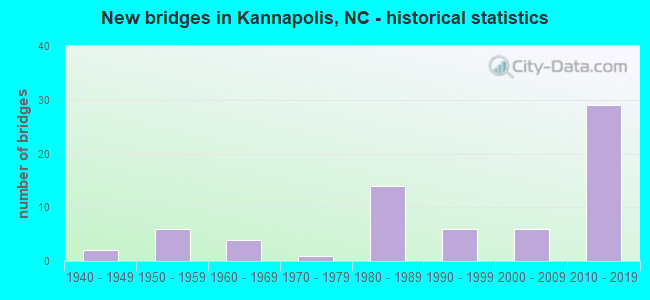
- New bridges - historical statistics
- 21940-1949
- 61950-1959
- 41960-1969
- 11970-1979
- 141980-1989
- 61990-1999
- 62000-2009
- 292010-2019

- Reconstructed bridges - Historical Statistics
- 11970-1979
- 01980-1989
- 11990-1999


- Bridge Condition - Deck
- 25.0%Very good
- 41.7%Good
- 13.9%Satisfactory
- 16.7%Fair
- 2.8%Poor

- Bridge Condition - Superstructure
- 33.3%Very good
- 38.9%Good
- 8.3%Satisfactory
- 13.9%Fair
- 5.6%Poor

- Bridge Condition - Substructure
- 38.9%Very good
- 27.8%Good
- 16.7%Satisfactory
- 8.3%Fair
- 5.6%Poor
- 2.8%Serious

- Bridge Condition - Channel
- 2.3%Very good
- 69.8%Good
- 14.0%Satisfactory
- 14.0%Fair

- Bridge Condition - Culverts
- 6.7%Very good
- 40.0%Good
- 40.0%Satisfactory
- 6.7%Fair
- 6.7%Poor
Find on map >> Show street view
Structure Number: 1590244, Location: 0.4 MI.E.JCT.SR2705 (Lat: 35.523372, Lng: -80.643597), Route carried "on" structure: State highway 1104, Year Built: 1983, Status: Open, Structure Length: 6.15m (20.18ft), Average Daily Traffic: 1,600 (year 2014), Truck Traffic: 7%, Average Future Daily Traffic: 3,200 (year 2040), Design Load: HS 20+Mod, Features Intersected: KANNAPOLIS LAKE
Minimum Vertical Clearance: 30+ m (98+ ft), Kilometerpoint: 0.000, Lanes on structure: 2, Owner: State Highway Agency, Approaching Roadway Width: 9.1m (29.9ft), Material/Design: Prestressed concrete, Design/Construction: Slab, Number Of Spans In Main Unit: 4, Length of Maximum Span: 14.9m (48.9ft), Curb-To-Curb Width: 9.1m (29.9ft), Out-to-Out Width: 10.0m (32.8ft)
Condition: Deck: Good, Superstructure: Good, Substructure: Good, Channel: Good, Operating Rating: 71.6 metric tons, Method Used To Determine Operating Rating: Load Factor (LF), Inventory Rating: 42.6 metric tons, Method Used To Determine Inventory Rating: Load Factor (LF), Structural Evaluation: Better than present minimum criteria, Deck Geometry: Somewhat better than minimum adequacy, Waterway Adequacy: Better than present minimum criteria, Approach Roadway Alignment: Equal to present desirable criteria, Designated Inspection Frequency: Every 24 months, Underwater Inspection Frequency: Every 60 months, Inspection Date: September 2020, Underwater Inspection Date: Febuary 2022, Deck Structure Type: Concrete Precast Panels, Wearing Surface/Protective System: Wearing Surface: Bituminous
Find on map >> Show street view
Structure Number: 1590277, Location: .01MI.N.JCT.W.C.STREET (Lat: 35.509503, Lng: -80.646414), Route carried "on" structure: City street , Year Built: 2008, Status: Open, Structure Length: 1.06m (3.48ft), Average Daily Traffic: 900 (year 1991), Truck Traffic: 7%, Average Future Daily Traffic: 1,800 (year 2040), Design Load: HS 20+Mod, Features Intersected: UT TO IRISH BUFFALO CREE, Facility Carried by Structure: PUMP STATION RD.
Minimum Vertical Clearance: 30+ m (98+ ft), Kilometerpoint: 0.000, Lanes on structure: 2, Owner: City or Municipal Highway Agency, Approaching Roadway Width: 7.6m (24.9ft), Skew: 2 degrees, Material/Design: Concrete continuous, Design/Construction: Culvert, Number Of Spans In Main Unit: 3, Length of Maximum Span: 3.0m (9.8ft)
Condition: Channel: Fair, Culverts: Good, Operating Rating: 89.8 metric tons, Method Used To Determine Operating Rating: Load and Resistance Factor (LRFR), Inventory Rating: 81.6 metric tons, Method Used To Determine Inventory Rating: Load and Resistance Factor (LRFR), Structural Evaluation: Better than present minimum criteria, Waterway Adequacy: Better than present minimum criteria, Approach Roadway Alignment: Equal to present desirable criteria, Designated Inspection Frequency: Every 24 months, Inspection Date: January 2022
Find on map >> Show street view
Structure Number: 159034, Location: 0.3 MI. N. JCT. SR2168 (Lat: 35.659297, Lng: -80.373989), Route carried "on" structure: State highway 2170, Year Built: 1983, Status: Open, Structure Length: 0.76m (2.49ft), Average Daily Traffic: 250 (year 2000), Truck Traffic: 6%, Average Future Daily Traffic: 500 (year 2040), Design Load: HS 20+Mod, Features Intersected: SMALL CREEK
Minimum Vertical Clearance: 30+ m (98+ ft), Kilometerpoint: 0.000, Lanes on structure: 2, Owner: State Highway Agency, Approaching Roadway Width: 6.0m (19.7ft), Skew: 2 degrees, Material/Design: Steel, Design/Construction: Culvert, Number Of Spans In Main Unit: 2, Length of Maximum Span: 3.3m (10.8ft)
Condition: Channel: Good, Culverts: Good, Operating Rating: 89.8 metric tons, Method Used To Determine Operating Rating: Load and Resistance Factor (LRFR), Inventory Rating: 89.8 metric tons, Method Used To Determine Inventory Rating: Load and Resistance Factor (LRFR), Structural Evaluation: Better than present minimum criteria, Waterway Adequacy: Better than present minimum criteria, Approach Roadway Alignment: Equal to present desirable criteria, Designated Inspection Frequency: Every 24 months, Underwater Inspection Frequency: Every 60 months, Inspection Date: October 2020, Underwater Inspection Date: October 2020
Find on map >> Show street view
Structure Number: 1590342, Location: 0.1 MI.N.MOUNTAIN ST. (Lat: 35.509694, Lng: -80.636731), Route carried "on" structure: City street , Year Built: 1960, Status: Open, Structure Length: 0.97m (3.18ft), Average Daily Traffic: 1,300 (year 1991), Truck Traffic: 7%, Average Future Daily Traffic: 2,600 (year 2040), Design Load: HS 20+Mod, Features Intersected: BAKERS CREEK, Facility Carried by Structure: GLENN AVENUE
Minimum Vertical Clearance: 30+ m (98+ ft), Kilometerpoint: 0.000, Lanes on structure: 2, Owner: City or Municipal Highway Agency, Approaching Roadway Width: 6.7m (22.0ft), Skew: 1 degrees, Material/Design: Concrete continuous, Design/Construction: Culvert, Number Of Spans In Main Unit: 3, Length of Maximum Span: 3.0m (9.8ft)
Condition: Channel: Satisfactory, Culverts: Good, Operating Rating: 63.5 metric tons, Method Used To Determine Operating Rating: Load Factor (LF), Inventory Rating: 48.9 metric tons, Method Used To Determine Inventory Rating: Load Factor (LF), Structural Evaluation: Better than present minimum criteria, Waterway Adequacy: Better than present minimum criteria, Approach Roadway Alignment: Equal to present desirable criteria, Designated Inspection Frequency: Every 24 months, Inspection Date: January 2022
Find on map >> Show street view
Structure Number: 1590351, Location: 0.6 MI. E. JCT. SR1506 (Lat: 35.599069, Lng: -80.566911), Route carried "on" structure: State highway 1505, Year Built: 1995, Status: Open, Structure Length: 2.95m (9.68ft), Average Daily Traffic: 1,600 (year 2012), Truck Traffic: 6%, Average Future Daily Traffic: 3,200 (year 2040), Design Load: HS 20+Mod, Features Intersected: GRANTS CREEK
Minimum Vertical Clearance: 30+ m (98+ ft), Kilometerpoint: 0.000, Lanes on structure: 2, Owner: State Highway Agency, Approaching Roadway Width: 5.7m (18.7ft), Material/Design: Prestressed concrete, Design/Construction: Slab, Number Of Spans In Main Unit: 3, Length of Maximum Span: 10.3m (33.8ft), Curb-To-Curb Width: 7.3m (24.0ft), Out-to-Out Width: 8.2m (26.9ft)
Condition: Deck: Very good, Superstructure: Very good, Substructure: Good, Channel: Good, Operating Rating: 89.8 metric tons, Method Used To Determine Operating Rating: Load Factor (LF), Inventory Rating: 53.5 metric tons, Method Used To Determine Inventory Rating: Load Factor (LF), Structural Evaluation: Better than present minimum criteria, Deck Geometry: Meets minimum limits, Waterway Adequacy: Better than present minimum criteria, Approach Roadway Alignment: Equal to present desirable criteria, Designated Inspection Frequency: Every 24 months, Inspection Date: July 2020, Deck Structure Type: Concrete Precast Panels, Wearing Surface/Protective System: Wearing Surface: Bituminous
Find on map >> Show street view
Structure Number: 1590353, Location: 0.3 MI. S. JCT. SR1308 (Lat: 35.505258, Lng: -80.560197), Route carried "on" structure: State highway 1349, Year Built: 2017, Status: Open, Structure Length: 0.88m (2.89ft), Average Daily Traffic: 1,300 (year 2016), Truck Traffic: 7%, Average Future Daily Traffic: 2,600 (year 2040), Design Load: HL 93, Features Intersected: UT TO COLD WATER CREEK
Minimum Vertical Clearance: 30+ m (98+ ft), Kilometerpoint: 0.000, Lanes on structure: 2, Owner: State Highway Agency, Approaching Roadway Width: 8.8m (28.9ft), Material/Design: Concrete continuous, Design/Construction: Culvert, Number Of Spans In Main Unit: 2, Length of Maximum Span: 3.9m (12.8ft)
Condition: Channel: Fair, Culverts: Very good, Operating Rating: 44.4 metric tons, Method Used To Determine Operating Rating: Load and Resistance Factor (LRFR), Inventory Rating: 33.5 metric tons, Method Used To Determine Inventory Rating: Load and Resistance Factor (LRFR), Structural Evaluation: Equal to present desirable criteria, Waterway Adequacy: Better than present minimum criteria, Approach Roadway Alignment: Equal to present desirable criteria, Designated Inspection Frequency: Every 24 months, Inspection Date: December 2021
Find on map >> Show street view
Structure Number: 1590382, Location: 100 ft.W.JCT.MARIE AVE. (Lat: 35.504867, Lng: -80.600958), Route carried "on" structure: City street , Year Built: 1940, Status: Open, Structure Length: 0.70m (2.30ft), Average Daily Traffic: 3,100 (year 2016), Truck Traffic: 7%, Average Future Daily Traffic: 6,200 (year 2040), Design Load: HS 20, Features Intersected: UNNAMED CREEK, Facility Carried by Structure: JACKSON ST.
Minimum Vertical Clearance: 30+ m (98+ ft), Kilometerpoint: 0.000, Lanes on structure: 2, Owner: City or Municipal Highway Agency, Approaching Roadway Width: 8.2m (26.9ft), Skew: 4 degrees, Material/Design: Steel, Design/Construction: Culvert, Number Of Spans In Main Unit: 2, Length of Maximum Span: 2.1m (6.9ft)
Condition: Channel: Good, Culverts: Satisfactory, Operating Rating: 73.4 metric tons, Method Used To Determine Operating Rating: Load and Resistance Factor (LRFR), Inventory Rating: 73.4 metric tons, Method Used To Determine Inventory Rating: Load and Resistance Factor (LRFR), Structural Evaluation: Equal to present minimum criteria, Waterway Adequacy: Better than present minimum criteria, Approach Roadway Alignment: Equal to present desirable criteria, Designated Inspection Frequency: Every 24 months, Inspection Date: January 2022
Find on map >> Show street view
Structure Number: 1590468, Location: 0.1 MI. WEST FROM SR1238 (Lat: 35.533556, Lng: -80.602778), Route carried "on" structure: State highway 1221, Year Built: 2017, Status: Open, Structure Length: 0.70m (2.30ft), Average Daily Traffic: 3,400 (year 2016), Truck Traffic: 7%, Average Future Daily Traffic: 6,800 (year 2040), Design Load: HL 93, Features Intersected: UT TO COLD WATER
Minimum Vertical Clearance: 30+ m (98+ ft), Kilometerpoint: 0.000, Lanes on structure: 2, Owner: State Highway Agency, Approaching Roadway Width: 10.6m (34.8ft), Material/Design: Concrete continuous, Design/Construction: Culvert, Number Of Spans In Main Unit: 2, Length of Maximum Span: 3.3m (10.8ft)
Condition: Channel: Fair, Culverts: Good, Operating Rating: 89.8 metric tons, Method Used To Determine Operating Rating: Load and Resistance Factor (LRFR), Inventory Rating: 89.8 metric tons, Method Used To Determine Inventory Rating: Load and Resistance Factor (LRFR), Structural Evaluation: Better than present minimum criteria, Waterway Adequacy: Better than present minimum criteria, Approach Roadway Alignment: Equal to present desirable criteria, Designated Inspection Frequency: Every 24 months, Inspection Date: December 2020
Find on map >> Show street view
Structure Number: 250087, Location: 0.4 MI. N. JCT. US29A (Lat: 35.445933, Lng: -80.609114), Route carried "under" structure: Interstate 85, Year Built: 2017, Structure Length: 0. m, Average Daily Traffic: 42,500 (year 2018), Truck Traffic: 16%, Features Intersected: US29 NBL
Minimum Vertical Clearance: 5.71m (18.73ft), Kilometerpoint: 17.678, Lanes on structure: 3, Lanes under structure: 4, Material/Design: Prestressed concrete continuous, Design/Construction: Stringer/Multi-beam, Length of Maximum Span: 29.5m (96.8ft)
Find on map >> Show street view
Structure Number: 250087, Location: 0.4 MI. N. JCT. US29A (Lat: 35.445933, Lng: -80.609114), Route carried "under" structure: Interstate 85, Year Built: 2017, Structure Length: 0. m, Average Daily Traffic: 39,000 (year 2015), Truck Traffic: 16%, Features Intersected: US29 NBL
Minimum Vertical Clearance: 5.71m (18.73ft), Kilometerpoint: 17.678, Lanes on structure: 3, Lanes under structure: 2, Material/Design: Prestressed concrete continuous, Design/Construction: Stringer/Multi-beam, Length of Maximum Span: 29.5m (96.8ft)
Find on map >> Show street view
Structure Number: 250087, Location: 0.4 MI. N. JCT. US29A (Lat: 35.445933, Lng: -80.609114), Route carried "under" structure: Interstate 85, Year Built: 2017, Structure Length: 0. m, Average Daily Traffic: 42,500 (year 2018), Truck Traffic: 16%, Features Intersected: US29 NBL
Minimum Vertical Clearance: 5.61m (18.41ft), Kilometerpoint: 17.678, Lanes on structure: 3, Lanes under structure: 4, Material/Design: Prestressed concrete continuous, Design/Construction: Stringer/Multi-beam, Length of Maximum Span: 29.5m (96.8ft)
Find on map >> Show street view
Structure Number: 250109, Location: 0.8 MI. E. JCT. US29A (Lat: 35.492642, Lng: -80.611022), Route carried "under" structure: US 29, Year Built: 1953, Structure Length: 0. m, Average Daily Traffic: 10,500 (year 2012), Truck Traffic: 12%, Features Intersected: SR1706
Minimum Vertical Clearance: 4.51m (14.80ft), Kilometerpoint: 0.000, Lanes on structure: 2, Lanes under structure: 2, Material/Design: Steel, Design/Construction: Stringer/Multi-beam, Length of Maximum Span: 14.6m (47.9ft)
Find on map >> Show street view
Structure Number: 250109, Location: 0.8 MI. E. JCT. US29A (Lat: 35.492642, Lng: -80.611022), Route carried "under" structure: US 29, Year Built: 1953, Structure Length: 0. m, Average Daily Traffic: 10,500 (year 2012), Truck Traffic: 12%, Features Intersected: SR1706
Minimum Vertical Clearance: 4.99m (16.37ft), Kilometerpoint: 0.000, Lanes on structure: 2, Lanes under structure: 2, Material/Design: Steel, Design/Construction: Stringer/Multi-beam, Length of Maximum Span: 14.6m (47.9ft)
Find on map >> Show street view
Structure Number: 250139, Location: 0.4 MI. W. JCT. SR2119 (Lat: 35.480003, Lng: -80.577292), Route carried "under" structure: Interstate 85, Year Built: 2018, Structure Length: 0. m, Average Daily Traffic: 42,000 (year 2018), Truck Traffic: 16%, Features Intersected: SR2114
Minimum Vertical Clearance: 6.80m (22.31ft), Kilometerpoint: 18.623, Lanes on structure: 2, Lanes under structure: 4, Material/Design: Prestressed concrete, Design/Construction: Stringer/Multi-beam, Length of Maximum Span: 28.6m (93.8ft)
Find on map >> Show street view
Structure Number: 250139, Location: 0.4 MI. W. JCT. SR2119 (Lat: 35.480003, Lng: -80.577292), Route carried "under" structure: Interstate 85, Year Built: 2018, Structure Length: 0. m, Average Daily Traffic: 42,000 (year 2018), Truck Traffic: 16%, Features Intersected: SR2114
Minimum Vertical Clearance: 8.55m (28.05ft), Kilometerpoint: 0.000, Lanes on structure: 2, Lanes under structure: 4, Material/Design: Prestressed concrete, Design/Construction: Stringer/Multi-beam, Length of Maximum Span: 28.6m (93.8ft)
Find on map >> Show street view
Structure Number: 250144, Location: 0.3 MI. E. JCT. SR2122 (Lat: 35.490947, Lng: -80.569517), Route carried "under" structure: Interstate 85, Year Built: 2018, Structure Length: 0. m, Average Daily Traffic: 42,000 (year 2018), Truck Traffic: 16%, Features Intersected: SR2000
Minimum Vertical Clearance: 6.55m (21.49ft), Kilometerpoint: 18.867, Lanes on structure: 2, Lanes under structure: 4, Material/Design: Prestressed concrete, Design/Construction: Stringer/Multi-beam, Length of Maximum Span: 34.7m (113.8ft)
Find on map >> Show street view
Structure Number: 250144, Location: 0.3 MI. E. JCT. SR2122 (Lat: 35.490947, Lng: -80.569517), Route carried "under" structure: Interstate 85, Year Built: 2018, Structure Length: 0. m, Average Daily Traffic: 42,000 (year 2018), Truck Traffic: 16%, Features Intersected: SR2000
Minimum Vertical Clearance: 7.29m (23.92ft), Kilometerpoint: 18.867, Lanes on structure: 2, Lanes under structure: 4, Material/Design: Prestressed concrete, Design/Construction: Stringer/Multi-beam, Length of Maximum Span: 34.7m (113.8ft)
Find on map >> Show street view
Structure Number: 250147, Location: 0.2 MI. W. JCT. SR2205 (Lat: 35.497861, Lng: -80.563867), Route carried "under" structure: Interstate 85, Year Built: 2018, Structure Length: 0. m, Average Daily Traffic: 42,000 (year 2018), Truck Traffic: 16%, Features Intersected: SR2180
Minimum Vertical Clearance: 6.48m (21.26ft), Kilometerpoint: 19.202, Lanes on structure: 2, Lanes under structure: 4, Material/Design: Steel, Design/Construction: Stringer/Multi-beam, Length of Maximum Span: 29.2m (95.8ft)
Find on map >> Show street view
Structure Number: 250147, Location: 0.2 MI. W. JCT. SR2205 (Lat: 35.497861, Lng: -80.563867), Route carried "under" structure: Interstate 85, Year Built: 2018, Structure Length: 0. m, Average Daily Traffic: 42,000 (year 2018), Truck Traffic: 16%, Features Intersected: SR2180
Minimum Vertical Clearance: 5.73m (18.80ft), Kilometerpoint: 19.202, Lanes on structure: 2, Lanes under structure: 4, Material/Design: Steel, Design/Construction: Stringer/Multi-beam, Length of Maximum Span: 29.2m (95.8ft)
Find on map >> Show street view
Structure Number: 250303, Location: 0.55MI N. JCT SR 1706 (Lat: 35.504803, Lng: -80.618364), Route carried "under" structure: State highway 2000, Year Built: 1989, Structure Length: 0. m, Average Daily Traffic: 5,000 (year 2014), Truck Traffic: 6%, Features Intersected: RIDGE AVENUE
Minimum Vertical Clearance: 4.95m (16.24ft), Kilometerpoint: 0.000, Lanes on structure: 2, Lanes under structure: 3, Material/Design: Steel, Design/Construction: Stringer/Multi-beam, Length of Maximum Span: 17.0m (55.8ft)
Find on map >> Show street view
Structure Number: 1590032, Location: 0.2 MI. W. JCT. SR1349 (Lat: 35.509239, Lng: -80.564397), Route carried "under" structure: Interstate 85, Year Built: 2018, Structure Length: 0. m, Average Daily Traffic: 41,000 (year 2017), Truck Traffic: 16%, Features Intersected: SR1308
Minimum Vertical Clearance: 6.05m (19.85ft), Kilometerpoint: 0.000, Lanes on structure: 2, Lanes under structure: 2, Material/Design: Prestressed concrete, Design/Construction: Stringer/Multi-beam, Length of Maximum Span: 33.5m (109.9ft)
Find on map >> Show street view
Structure Number: 1590032, Location: 0.2 MI. W. JCT. SR1349 (Lat: 35.509239, Lng: -80.564397), Route carried "under" structure: Interstate 85, Year Built: 2018, Structure Length: 0. m, Average Daily Traffic: 41,000 (year 2017), Truck Traffic: 16%, Features Intersected: SR1308
Minimum Vertical Clearance: 6.96m (22.83ft), Kilometerpoint: 0.000, Lanes on structure: 2, Lanes under structure: 2, Material/Design: Prestressed concrete, Design/Construction: Stringer/Multi-beam, Length of Maximum Span: 33.5m (109.9ft)
Find on map >> Show street view
Structure Number: 1590084, Location: 0.1 MI.W.JCT.SR1232 (Lat: 35.541522, Lng: -80.573086), Route carried "under" structure: Interstate 85, Year Built: 2017, Structure Length: 0. m, Average Daily Traffic: 40,000 (year 2019), Truck Traffic: 16%, Features Intersected: SR1243
Minimum Vertical Clearance: 5.62m (18.44ft), Kilometerpoint: 20.025, Lanes on structure: 2, Lanes under structure: 2, Material/Design: Prestressed concrete, Design/Construction: Stringer/Multi-beam, Length of Maximum Span: 29.2m (95.8ft)
Find on map >> Show street view
Structure Number: 1590084, Location: 0.1 MI.W.JCT.SR1232 (Lat: 35.541522, Lng: -80.573086), Route carried "under" structure: Interstate 85, Year Built: 2017, Structure Length: 0. m, Average Daily Traffic: 40,000 (year 2019), Truck Traffic: 16%, Features Intersected: SR1243
Minimum Vertical Clearance: 5.79m (19.00ft), Kilometerpoint: 20.025, Lanes on structure: 2, Lanes under structure: 2, Material/Design: Prestressed concrete, Design/Construction: Stringer/Multi-beam, Length of Maximum Span: 29.2m (95.8ft)