Bridge Statistics for Kentwood, Michigan (MI)
Condition, Traffic, Stress, Structural Evaluation, Project Costs
- New bridges - historical statistics
- 11920-1929
- 41940-1949
- 61960-1969
- 81980-1989
- 131990-1999
- 202000-2009
- 42010-2019
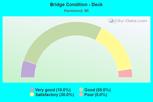
- Bridge Condition - Deck
- 10.0%Very good
- 55.0%Good
- 30.0%Satisfactory
- 5.0%Poor
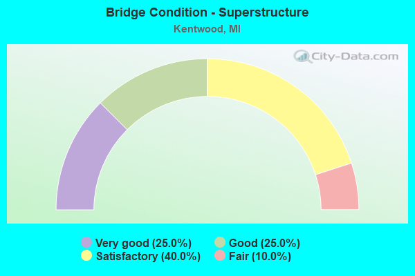
- Bridge Condition - Superstructure
- 25.0%Very good
- 25.0%Good
- 40.0%Satisfactory
- 10.0%Fair
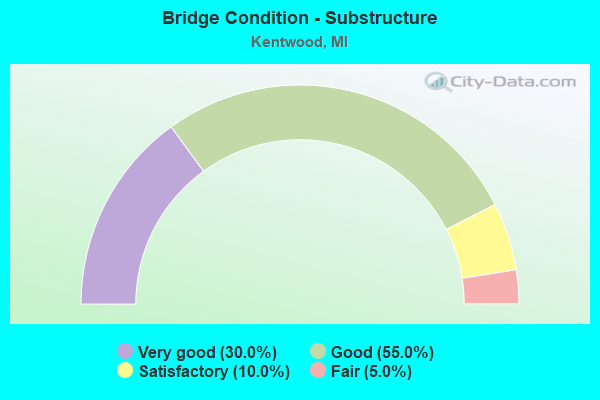
- Bridge Condition - Substructure
- 30.0%Very good
- 55.0%Good
- 10.0%Satisfactory
- 5.0%Fair
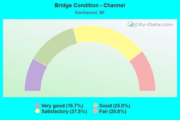
- Bridge Condition - Channel
- 16.7%Very good
- 25.0%Good
- 37.5%Satisfactory
- 20.8%Fair
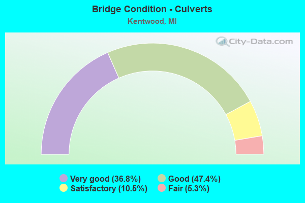
- Bridge Condition - Culverts
- 36.8%Very good
- 47.4%Good
- 10.5%Satisfactory
- 5.3%Fair
Find on map >> Show street view
Structure Number: 4744, Location: IN KENTWOOD (Lat: 42.928839, Lng: -85.559842), Route carried "on" structure: City street , Year Built: 1961, Status: Open, Structure Length: 8.99m (29.49ft), Average Daily Traffic: 4,416 (year 1996), Truck Traffic: 2%, Average Future Daily Traffic: 7,850 (year 2020), Design Load: H 20, Features Intersected: I-96, Facility Carried by Structure: FOREST HILL AVENUE
Minimum Vertical Clearance: 30.48m (100.00ft), Kilometerpoint: 0.855, Lanes on structure: 2, Lanes under structure: 4, Owner: State Highway Agency, Approaching Roadway Width: 10.3m (33.8ft), Skew: 4 degrees, Material/Design: Steel, Design/Construction: Stringer/Multi-beam, Number Of Spans In Main Unit: 4, Length of Maximum Span: 30.7m (100.7ft), Curb-To-Curb Width: 9.3m (30.5ft), Out-to-Out Width: 10.0m (32.8ft)
Condition: Deck: Satisfactory, Superstructure: Fair, Substructure: Fair, Operating Rating: 53.1 metric tons, Method Used To Determine Operating Rating: Load Factor (LF) rating reported by rating factor (RF) method using MS18 loading, Inventory Rating: 31.8 metric tons, Method Used To Determine Inventory Rating: Load Factor (LF) rating reported by rating factor (RF) method using MS18 loading, Structural Evaluation: Somewhat better than minimum adequacy, Deck Geometry: Meets minimum limits, Underclear: Meets minimum limits, Approach Roadway Alignment: Equal to present minimum criteria, Designated Inspection Frequency: Every 24 months, Inspection Date: March 2021, Deck Structure Type: Concrete Cast-file-Place, Wearing Surface/Protective System: Wearing Surface: Monolithic Concrete
Find on map >> Show street view
Structure Number: 4839, Location: 1.0 MI S OF M-11 (Lat: 42.899192, Lng: -85.577567), Route carried "on" structure: State highway 37, Year Built: 1946, Status: Open, Structure Length: 0.76m (2.49ft), Average Daily Traffic: 29,172 (year 2007), Truck Traffic: 4%, Average Future Daily Traffic: 31,488 (year 2018), Design Load: HS 20, Features Intersected: WHISKEY CK(LT PLSTER CR)
Minimum Vertical Clearance: 30.48m (100.00ft), Kilometerpoint: 11.634, Lanes on structure: 2, Base Highway Network: Yes (Inventory Route: 40, Subroute: 4), Owner: State Highway Agency, Approaching Roadway Width: 46.9m (153.9ft), Material/Design: Concrete, Design/Construction: Culvert, Number Of Spans In Main Unit: 2, Length of Maximum Span: 3.9m (12.8ft), Curb-To-Curb Width: 48.6m (159.4ft), Out-to-Out Width: 76.6m (251.3ft)
Condition: Channel: Good, Culverts: Good, Operating Rating: 44.7 metric tons, Method Used To Determine Operating Rating: Load Factor (LF) rating reported by rating factor (RF) method using MS18 loading, Inventory Rating: 26.9 metric tons, Method Used To Determine Inventory Rating: Load Factor (LF) rating reported by rating factor (RF) method using MS18 loading, Structural Evaluation: Equal to present minimum criteria, Deck Geometry: Superior to present desirable criteria, Waterway Adequacy: Equal to present desirable criteria, Approach Roadway Alignment: Equal to present desirable criteria, Designated Inspection Frequency: Every 24 months, Inspection Date: April 2021
Find on map >> Show street view
Structure Number: 4846, Location: 0.6 MI S OF M-11 (Lat: 42.905244, Lng: -85.581978), Route carried "on" structure: City street 2001, Year Built: 1948, Status: Open, Structure Length: 5.24m (17.19ft), Average Daily Traffic: 9,500 (year 1996), Truck Traffic: 2%, Average Future Daily Traffic: 12,100 (year 2020), Design Load: H 20, Features Intersected: M-37, Facility Carried by Structure: 32ND ST
Minimum Vertical Clearance: 30.48m (100.00ft), Kilometerpoint: 3.708, Lanes on structure: 2, Lanes under structure: 2, Owner: State Highway Agency, Approaching Roadway Width: 9.7m (31.8ft), Skew: 1 degrees, Material/Design: Steel, Design/Construction: Stringer/Multi-beam, Number Of Spans In Main Unit: 3, Length of Maximum Span: 17.3m (56.8ft), Curb or Sidewalk Widths: Left: 0.4m (1.3ft), Right: 0.4m (1.3ft), Curb-To-Curb Width: 9.7m (31.8ft), Out-to-Out Width: 11.2m (36.7ft)
Condition: Deck: Poor, Superstructure: Fair, Substructure: Good, Operating Rating: 56.4 metric tons, Method Used To Determine Operating Rating: Load Factor (LF) rating reported by rating factor (RF) method using MS18 loading, Inventory Rating: 29.5 metric tons, Method Used To Determine Inventory Rating: Load Factor (LF) rating reported by rating factor (RF) method using MS18 loading, Structural Evaluation: Somewhat better than minimum adequacy, Deck Geometry: High priority of corrective action, Underclear: Equal to present minimum criteria, Approach Roadway Alignment: Equal to present desirable criteria, Length Of Structure Improvement: 5.24m (17.19ft), Designated Inspection Frequency: Every 24 months, Inspection Date: April 2021, Bridge Improvement Cost: $886,000, Roadway Improvement Cost: $11,000, Total Project Cost: $130,000, Deck Structure Type: Concrete Cast-file-Place, Wearing Surface/Protective System: Wearing Surface: Monolithic Concrete
Find on map >> Show street view
Structure Number: 5063, Location: 0.50 MI S OF 68TH ST (Lat: 42.833919, Lng: -85.585161), Route carried "on" structure: County highway 4143, Year Built: 1967, Status: Open, Structure Length: 0.76m (2.49ft), Average Daily Traffic: 3,738 (year 2005), Average Future Daily Traffic: 6,350 (year 2025), Design Load: HS 20+Mod, Features Intersected: PLASTER CREEK, Facility Carried by Structure: HANNA LAKE AVE
Minimum Vertical Clearance: 30.48m (100.00ft), Kilometerpoint: 7.297, Lanes on structure: 2, Owner: County Highway Agency, Approaching Roadway Width: 10.4m (34.1ft), Material/Design: Concrete, Design/Construction: Culvert, Number Of Spans In Main Unit: 2, Length of Maximum Span: 3.3m (10.8ft)
Condition: Channel: Good, Culverts: Very good, Operating Rating: 48.6 metric tons, Method Used To Determine Operating Rating: Assigned rating based on Load Factor Design (LFD) reported by rating factor (RF) using MS18 loading, Inventory Rating: 32.4 metric tons, Method Used To Determine Inventory Rating: Assigned rating based on Load Factor Design (LFD) reported by rating factor (RF) using MS18 loading, Structural Evaluation: Equal to present desirable criteria, Waterway Adequacy: Equal to present desirable criteria, Approach Roadway Alignment: Equal to present desirable criteria, Designated Inspection Frequency: Every 24 months, Inspection Date: November 2021
Find on map >> Show street view
Structure Number: 5087, Location: 200 FT SE OF 60TH ST (Lat: 42.853992, Lng: -85.589644), Route carried "on" structure: County highway 4143, Year Built: 1928, Status: Open, Structure Length: 0.73m (2.40ft), Average Daily Traffic: 25 (year 2006), Average Future Daily Traffic: 40 (year 2026), Design Load: HS 20+Mod, Features Intersected: PLASTER CREEK, Facility Carried by Structure: WING AVE
Minimum Vertical Clearance: 30.48m (100.00ft), Kilometerpoint: 0.090, Lanes on structure: 2, Owner: County Highway Agency, Approaching Roadway Width: 7.3m (24.0ft), Material/Design: Concrete, Design/Construction: Culvert, Number Of Spans In Main Unit: 2, Length of Maximum Span: 3.6m (11.8ft)
Condition: Channel: Good, Culverts: Good, Operating Rating: 42.4 metric tons, Method Used To Determine Operating Rating: Load Factor (LF) rating reported by rating factor (RF) method using MS18 loading, Inventory Rating: 33.0 metric tons, Method Used To Determine Inventory Rating: Load Factor (LF) rating reported by rating factor (RF) method using MS18 loading, Structural Evaluation: Better than present minimum criteria, Waterway Adequacy: Equal to present desirable criteria, Approach Roadway Alignment: Equal to present minimum criteria, Designated Inspection Frequency: Every 24 months, Inspection Date: November 2021
Find on map >> Show street view
Structure Number: 5092, Location: 0.25 MI E OF SHAFFER AVE (Lat: 42.883514, Lng: -85.581564), Route carried "on" structure: City street 2001, Year Built: 1982, Status: Open, Structure Length: 1.34m (4.40ft), Average Daily Traffic: 22,342 (year 2005), Average Future Daily Traffic: 37,980 (year 2025), Design Load: HS 20+Mod, Features Intersected: PLASTER CREEK, Facility Carried by Structure: 44TH STREET
Minimum Vertical Clearance: 30.48m (100.00ft), Kilometerpoint: 7.204, Lanes on structure: 4, Owner: City or Municipal Highway Agency, Approaching Roadway Width: 17.1m (56.1ft), Skew: 31 degrees, Material/Design: Prestressed concrete, Design/Construction: Box Beam or Girders - Multiple, Number Of Spans In Main Unit: 1, Length of Maximum Span: 12.2m (40.0ft), Curb or Sidewalk Widths: Left: 1.5m (4.9ft), Right: 1.5m (4.9ft), Curb-To-Curb Width: 20.1m (65.9ft), Out-to-Out Width: 26.3m (86.3ft)
Condition: Deck: Satisfactory, Superstructure: Satisfactory, Substructure: Good, Channel: Fair, Operating Rating: 55.3 metric tons, Method Used To Determine Operating Rating: Load Factor (LF), Inventory Rating: 33.1 metric tons, Method Used To Determine Inventory Rating: Load Factor (LF), Structural Evaluation: Equal to present minimum criteria, Deck Geometry: Better than present minimum criteria, Waterway Adequacy: Equal to present minimum criteria, Approach Roadway Alignment: Equal to present desirable criteria, Designated Inspection Frequency: Every 24 months, Inspection Date: June 2021, Deck Structure Type: Concrete Precast Panels, Wearing Surface/Protective System: Wearing Surface: Bituminous, Membrane: Preformed Fabric
Find on map >> Show street view
Structure Number: 514, Location: 200 FT E OF HANNA LAKE (Lat: 42.854572, Lng: -85.584339), Route carried "on" structure: County highway , Year Built: 2002, Status: Open, Structure Length: 1.11m (3.64ft), Average Daily Traffic: 7,047 (year 2005), Average Future Daily Traffic: 11,980 (year 2025), Design Load: HS 20+Mod, Features Intersected: ANDERSON COUNTY DRAIN, Facility Carried by Structure: 60TH STREET
Minimum Vertical Clearance: 30.48m (100.00ft), Kilometerpoint: 6.982, Lanes on structure: 2, Owner: County Highway Agency, Approaching Roadway Width: 19.2m (63.0ft), Material/Design: Concrete, Design/Construction: Culvert, Number Of Spans In Main Unit: 2, Length of Maximum Span: 11.1m (36.4ft), Curb-To-Curb Width: 19.5m (64.0ft), Out-to-Out Width: 20.4m (66.9ft)
Condition: Channel: Very good, Culverts: Very good, Operating Rating: 84.6 metric tons, Method Used To Determine Operating Rating: Load Factor (LF) rating reported by rating factor (RF) method using MS18 loading, Inventory Rating: 65.4 metric tons, Method Used To Determine Inventory Rating: Load Factor (LF) rating reported by rating factor (RF) method using MS18 loading, Structural Evaluation: Equal to present desirable criteria, Deck Geometry: Superior to present desirable criteria, Waterway Adequacy: Equal to present desirable criteria, Approach Roadway Alignment: Equal to present desirable criteria, Designated Inspection Frequency: Every 24 months, Inspection Date: November 2021, Deck Structure Type: Concrete Cast-file-Place
Find on map >> Show street view
Structure Number: 5141, Location: 0.30 MI N OF 76TH ST (Lat: 42.830872, Lng: -85.575272), Route carried "on" structure: County highway , Year Built: 2009, Status: Open, Structure Length: 0.79m (2.59ft), Average Daily Traffic: 5,268 (year 2009), Truck Traffic: 8%, Average Future Daily Traffic: 9,515 (year 2029), Design Load: HS 20, Features Intersected: SCHOOLEY DRAIN, Facility Carried by Structure: HAMMOND AVE
Minimum Vertical Clearance: 30.48m (100.00ft), Kilometerpoint: 0.480, Lanes on structure: 2, Owner: County Highway Agency, Approaching Roadway Width: 13.1m (43.0ft), Material/Design: Concrete, Design/Construction: Culvert, Number Of Spans In Main Unit: 1, Length of Maximum Span: 7.3m (24.0ft), Curb-To-Curb Width: 13.1m (43.0ft), Out-to-Out Width: 13.4m (44.0ft)
Condition: Channel: Very good, Culverts: Very good, Operating Rating: 69.0 metric tons, Method Used To Determine Operating Rating: Load and Resistance Factor Rating (LRFR) rating reported by rating factor(RF) method using HL-93 loadings, Inventory Rating: 53.1 metric tons, Method Used To Determine Inventory Rating: Load and Resistance Factor Rating (LRFR) rating reported by rating factor(RF) method using HL-93 loadings, Structural Evaluation: Equal to present desirable criteria, Deck Geometry: Somewhat better than minimum adequacy, Waterway Adequacy: Equal to present desirable criteria, Approach Roadway Alignment: Equal to present desirable criteria, Designated Inspection Frequency: Every 24 months, Inspection Date: November 2021
Find on map >> Show street view
Structure Number: 5142, Location: 0.20 MI N OF 68TH ST (Lat: 42.844933, Lng: -85.594836), Route carried "on" structure: County highway , Year Built: 1992, Status: Open, Structure Length: 1.15m (3.77ft), Average Daily Traffic: 540 (year 2006), Truck Traffic: 5%, Average Future Daily Traffic: 920 (year 2026), Design Load: HS 20, Features Intersected: PLASTER CREEK, Facility Carried by Structure: LEISURE CREEK DRV
Minimum Vertical Clearance: 30.48m (100.00ft), Kilometerpoint: 0.435, Lanes on structure: 2, Owner: County Highway Agency, Approaching Roadway Width: 9.1m (29.9ft), Skew: 4 degrees, Material/Design: Concrete, Design/Construction: Culvert, Number Of Spans In Main Unit: 1, Length of Maximum Span: 10.9m (35.8ft), Curb or Sidewalk Widths: Left: 1.3m (4.3ft), Right: 1.3m (4.3ft)
Condition: Channel: Fair, Culverts: Fair, Operating Rating: 42.1 metric tons, Method Used To Determine Operating Rating: Load Factor (LF) rating reported by rating factor (RF) method using MS18 loading, Inventory Rating: 30.8 metric tons, Method Used To Determine Inventory Rating: Load Factor (LF) rating reported by rating factor (RF) method using MS18 loading, Structural Evaluation: Somewhat better than minimum adequacy, Waterway Adequacy: Equal to present desirable criteria, Approach Roadway Alignment: Equal to present minimum criteria, Designated Inspection Frequency: Every 24 months, Inspection Date: November 2021
Find on map >> Show street view
Structure Number: 5224, Location: 0.6 MI W OF EAST PARIS AV (Lat: 42.869061, Lng: -85.577942), Route carried "on" structure: City street 2001, Year Built: 1969, Year Reconstructed: 1995, Status: Open, Structure Length: 1.55m (5.09ft), Average Daily Traffic: 14,694 (year 1997), Average Future Daily Traffic: 26,000 (year 2017), Design Load: HS 20+Mod, Features Intersected: PLASTER CREEK, Facility Carried by Structure: 52ND STREET
Minimum Vertical Clearance: 30.48m (100.00ft), Kilometerpoint: 7.320, Lanes on structure: 4, Owner: City or Municipal Highway Agency, Approaching Roadway Width: 13.4m (44.0ft), Material/Design: Steel, Design/Construction: Culvert, Number Of Spans In Main Unit: 3, Length of Maximum Span: 4.5m (14.8ft)
Condition: Channel: Satisfactory, Culverts: Satisfactory, Operating Rating: 97.2 metric tons, Method Used To Determine Operating Rating: Load Factor (LF) rating reported by rating factor (RF) method using MS18 loading, Inventory Rating: 97.2 metric tons, Method Used To Determine Inventory Rating: Load Factor (LF) rating reported by rating factor (RF) method using MS18 loading, Structural Evaluation: Equal to present minimum criteria, Waterway Adequacy: Better than present minimum criteria, Approach Roadway Alignment: Equal to present desirable criteria, Designated Inspection Frequency: Every 24 months, Inspection Date: June 2021
Find on map >> Show street view
Structure Number: 5225, Location: 0.5 MI W OF EAST PARIS AV (Lat: 42.905250, Lng: -85.579625), Route carried "on" structure: County highway , Year Built: 2001, Status: Open, Structure Length: 0.67m (2.20ft), Average Daily Traffic: 7,333 (year 2003), Truck Traffic: 10%, Average Future Daily Traffic: 10,490 (year 2023), Design Load: H 20, Features Intersected: WHISKEY CREEK, Facility Carried by Structure: 32ND STREET
Minimum Vertical Clearance: 30+ m (98+ ft), Kilometerpoint: 3.901, Lanes on structure: 2, Owner: City or Municipal Highway Agency, Approaching Roadway Width: 9.1m (29.9ft), Skew: 2 degrees, Material/Design: Concrete, Design/Construction: Culvert, Number Of Spans In Main Unit: 1, Length of Maximum Span: 6.7m (22.0ft), Curb or Sidewalk Widths: Left: 2.1m (6.9ft), Right: 2.1m (6.9ft)
Condition: Channel: Satisfactory, Culverts: Satisfactory, Structural Evaluation: Equal to present minimum criteria, Waterway Adequacy: Better than present minimum criteria, Approach Roadway Alignment: Equal to present minimum criteria, Designated Inspection Frequency: Every 24 months, Inspection Date: June 2021
Find on map >> Show street view
Structure Number: 5226, Location: 0.20 MI S OF 32ND ST (Lat: 42.902247, Lng: -85.607425), Route carried "on" structure: City street 2001, Year Built: 1989, Status: Open, Structure Length: 3.53m (11.58ft), Average Daily Traffic: 21,333 (year 2003), Average Future Daily Traffic: 31,500 (year 2023), Design Load: HS 20+Mod, Features Intersected: PLASTER CREEK, Facility Carried by Structure: BRETON AVE
Minimum Vertical Clearance: 30.48m (100.00ft), Kilometerpoint: 4.069, Lanes on structure: 2, Owner: City or Municipal Highway Agency, Approaching Roadway Width: 12.2m (40.0ft), Material/Design: Prestressed concrete, Design/Construction: Box Beam or Girders - Multiple, Number Of Spans In Main Unit: 3, Length of Maximum Span: 15.8m (51.8ft), Curb or Sidewalk Widths: Left: 2.4m (7.9ft), Right: 2.4m (7.9ft), Curb-To-Curb Width: 14.6m (47.9ft), Out-to-Out Width: 20.2m (66.3ft)
Condition: Deck: Good, Superstructure: Satisfactory, Substructure: Satisfactory, Channel: Satisfactory, Operating Rating: 88.2 metric tons, Method Used To Determine Operating Rating: Load Factor (LF), Inventory Rating: 52.3 metric tons, Method Used To Determine Inventory Rating: Load Factor (LF), Structural Evaluation: Equal to present minimum criteria, Deck Geometry: Superior to present desirable criteria, Waterway Adequacy: Equal to present desirable criteria, Approach Roadway Alignment: Equal to present desirable criteria, Designated Inspection Frequency: Every 24 months, Inspection Date: June 2021, Deck Structure Type: Concrete Cast-file-Place, Wearing Surface/Protective System: Wearing Surface: Monolithic Concrete, Deck Protection: Epoxy Coated Reinforcing
Find on map >> Show street view
Structure Number: 5227, Location: 0.30 MI N OF 36TH ST (Lat: 42.901994, Lng: -85.587736), Route carried "on" structure: City street 2001, Year Built: 1982, Status: Posted for load, Structure Length: 4.26m (13.98ft), Average Daily Traffic: 13,333 (year 2003), Average Future Daily Traffic: 19,667 (year 2023), Design Load: HS 20+Mod, Features Intersected: PLASTER CREEK, Facility Carried by Structure: SHAFFER AVE
Minimum Vertical Clearance: 30.48m (100.00ft), Kilometerpoint: 2.055, Lanes on structure: 4, Owner: City or Municipal Highway Agency, Approaching Roadway Width: 15.9m (52.2ft), Material/Design: Prestressed concrete, Design/Construction: Box Beam or Girders - Multiple, Number Of Spans In Main Unit: 2, Length of Maximum Span: 21.3m (69.9ft), Curb or Sidewalk Widths: Left: 1.7m (5.6ft), Right: 1.7m (5.6ft), Curb-To-Curb Width: 15.9m (52.2ft), Out-to-Out Width: 20.1m (65.9ft)
Condition: Deck: Satisfactory, Superstructure: Satisfactory, Substructure: Good, Channel: Satisfactory, Operating Rating: 67.7 metric tons, Method Used To Determine Operating Rating: Load Factor (LF), Inventory Rating: 30.8 metric tons, Method Used To Determine Inventory Rating: Load Factor (LF), Structural Evaluation: Equal to present minimum criteria, Deck Geometry: Meets minimum limits, Waterway Adequacy: Equal to present desirable criteria, Approach Roadway Alignment: Equal to present desirable criteria, Bridge Posting: Required (Relationship of Operating Rating to Maximum Legal Load: 0.1 - 9.9% below), Designated Inspection Frequency: Every 24 months, Inspection Date: June 2021, Deck Structure Type: Concrete Cast-file-Place, Wearing Surface/Protective System: Wearing Surface: Bituminous, Membrane: Preformed Fabric, Deck Protection: Epoxy Coated Reinforcing
Find on map >> Show street view
Structure Number: 5228, Location: 300 FT N OF 36TH ST (Lat: 42.899144, Lng: -85.587581), Route carried "on" structure: City street 2001, Year Built: 1983, Status: Posted for load, Structure Length: 1.82m (5.97ft), Average Daily Traffic: 13,333 (year 2003), Average Future Daily Traffic: 19,667 (year 2023), Design Load: HS 20+Mod, Features Intersected: PLASTER CREEK, Facility Carried by Structure: SHAFFER AVE
Minimum Vertical Clearance: 30.48m (100.00ft), Kilometerpoint: 1.738, Lanes on structure: 4, Owner: City or Municipal Highway Agency, Approaching Roadway Width: 15.9m (52.2ft), Material/Design: Prestressed concrete, Design/Construction: Box Beam or Girders - Multiple, Number Of Spans In Main Unit: 1, Length of Maximum Span: 18.2m (59.7ft), Curb or Sidewalk Widths: Left: 1.7m (5.6ft), Right: 1.7m (5.6ft), Curb-To-Curb Width: 15.9m (52.2ft), Out-to-Out Width: 20.1m (65.9ft)
Condition: Deck: Satisfactory, Superstructure: Satisfactory, Substructure: Good, Channel: Satisfactory, Operating Rating: 68.4 metric tons, Method Used To Determine Operating Rating: Load Factor (LF), Inventory Rating: 36.1 metric tons, Method Used To Determine Inventory Rating: Load Factor (LF), Structural Evaluation: Equal to present minimum criteria, Deck Geometry: Meets minimum limits, Waterway Adequacy: Equal to present desirable criteria, Approach Roadway Alignment: Equal to present desirable criteria, Bridge Posting: Required (Relationship of Operating Rating to Maximum Legal Load: 0.1 - 9.9% below), Designated Inspection Frequency: Every 24 months, Inspection Date: June 2021, Deck Structure Type: Concrete Cast-file-Place, Wearing Surface/Protective System: Wearing Surface: Latex Concrete, Deck Protection: Epoxy Coated Reinforcing
Find on map >> Show street view
Structure Number: 5229, Location: 0.2 MI S OF 36TH ST (Lat: 42.895022, Lng: -85.587311), Route carried "on" structure: City street 2001, Year Built: 1983, Status: Posted for load, Structure Length: 1.82m (5.97ft), Average Daily Traffic: 9,333 (year 2003), Average Future Daily Traffic: 12,700 (year 2023), Design Load: HS 20+Mod, Features Intersected: PLASTER CREEK, Facility Carried by Structure: SHAFFER AVE
Minimum Vertical Clearance: 30.48m (100.00ft), Kilometerpoint: 1.279, Lanes on structure: 4, Owner: City or Municipal Highway Agency, Approaching Roadway Width: 15.9m (52.2ft), Material/Design: Prestressed concrete, Design/Construction: Box Beam or Girders - Multiple, Number Of Spans In Main Unit: 1, Length of Maximum Span: 18.2m (59.7ft), Curb or Sidewalk Widths: Left: 1.7m (5.6ft), Right: 1.7m (5.6ft), Curb-To-Curb Width: 15.9m (52.2ft), Out-to-Out Width: 20.1m (65.9ft)
Condition: Deck: Satisfactory, Superstructure: Satisfactory, Substructure: Good, Channel: Satisfactory, Operating Rating: 68.4 metric tons, Method Used To Determine Operating Rating: Load Factor (LF), Inventory Rating: 36.1 metric tons, Method Used To Determine Inventory Rating: Load Factor (LF), Structural Evaluation: Equal to present minimum criteria, Deck Geometry: Meets minimum limits, Waterway Adequacy: Equal to present desirable criteria, Approach Roadway Alignment: Equal to present desirable criteria, Bridge Posting: Required (Relationship of Operating Rating to Maximum Legal Load: 0.1 - 9.9% below), Designated Inspection Frequency: Every 24 months, Inspection Date: June 2021, Deck Structure Type: Concrete Cast-file-Place, Wearing Surface/Protective System: Wearing Surface: Latex Concrete, Deck Protection: Epoxy Coated Reinforcing
Find on map >> Show street view
Structure Number: 12699, Location: 0.2 MI NORTH 0F 36TH ST (Lat: 42.900483, Lng: -85.567961), Route carried "on" structure: City street , Year Built: 1997, Status: Open, Structure Length: 0.78m (2.56ft), Average Daily Traffic: 15,333 (year 2003), Truck Traffic: 5%, Average Future Daily Traffic: 27,000 (year 2023), Design Load: HS 20, Features Intersected: LITTLE PLASTER CREEK, Facility Carried by Structure: EAST PARIS AVENUE
Minimum Vertical Clearance: 30.48m (100.00ft), Kilometerpoint: 3.130, Lanes on structure: 5, Owner: City or Municipal Highway Agency, Approaching Roadway Width: 18.0m (59.1ft), Material/Design: Concrete, Design/Construction: Culvert, Number Of Spans In Main Unit: 1, Length of Maximum Span: 7.3m (24.0ft), Curb or Sidewalk Widths: Left: 2.9m (9.5ft), Right: 2.9m (9.5ft), Curb-To-Curb Width: 18.0m (59.1ft), Out-to-Out Width: 24.5m (80.4ft)
Condition: Channel: Good, Culverts: Good, Operating Rating: 53.8 metric tons, Method Used To Determine Operating Rating: Load Factor (LF) rating reported by rating factor (RF) method using MS18 loading, Inventory Rating: 32.1 metric tons, Method Used To Determine Inventory Rating: Load Factor (LF) rating reported by rating factor (RF) method using MS18 loading, Structural Evaluation: Better than present minimum criteria, Deck Geometry: High priority of replacement, Waterway Adequacy: Equal to present desirable criteria, Approach Roadway Alignment: Equal to present desirable criteria, Designated Inspection Frequency: Every 24 months, Inspection Date: June 2021
Find on map >> Show street view
Structure Number: 12741, Location: CALEDONIA TWP SEC 6 (Lat: 42.850858, Lng: -85.538894), Route carried "on" structure: State highway 6, Year Built: 1997, Status: Open, Structure Length: 8.02m (26.31ft), Average Daily Traffic: 20,090 (year 2007), Truck Traffic: 13%, Average Future Daily Traffic: 9,082 (year 2018), Design Load: HS 25 or greater, Features Intersected: M-37
Minimum Vertical Clearance: 30.48m (100.00ft), Kilometerpoint: 20.349, Lanes on structure: 3, Lanes under structure: 2, Base Highway Network: Yes (Inventory Route: 200, Subroute: 1), Owner: State Highway Agency, Approaching Roadway Width: 18.0m (59.1ft), Skew: 1 degrees, Material/Design: Prestressed concrete, Design/Construction: Stringer/Multi-beam, Number Of Spans In Main Unit: 2, Length of Maximum Span: 40.1m (131.6ft), Curb-To-Curb Width: 17.6m (57.7ft), Out-to-Out Width: 18.6m (61.0ft)
Condition: Deck: Good, Superstructure: Good, Substructure: Good, Operating Rating: 64.5 metric tons, Method Used To Determine Operating Rating: Load Factor (LF) rating reported by rating factor (RF) method using MS18 loading, Inventory Rating: 22.7 metric tons, Method Used To Determine Inventory Rating: Load Factor (LF) rating reported by rating factor (RF) method using MS18 loading, Structural Evaluation: Somewhat better than minimum adequacy, Deck Geometry: Better than present minimum criteria, Underclear: Better than present minimum criteria, Approach Roadway Alignment: Equal to present desirable criteria, Designated Inspection Frequency: Every 24 months, Inspection Date: May 2021, Deck Structure Type: Concrete Cast-file-Place, Wearing Surface/Protective System: Wearing Surface: Monolithic Concrete, Deck Protection: Epoxy Coated Reinforcing
Find on map >> Show street view
Structure Number: 12742, Location: CALENDONIA TWP SEC 6 (Lat: 42.851236, Lng: -85.539236), Route carried "on" structure: State highway 6, Year Built: 1997, Status: Open, Structure Length: 8.02m (26.31ft), Average Daily Traffic: 20,090 (year 2007), Truck Traffic: 13%, Average Future Daily Traffic: 8,051 (year 2018), Design Load: HS 25 or greater, Features Intersected: M-37
Minimum Vertical Clearance: 30.48m (100.00ft), Kilometerpoint: 20.325, Lanes on structure: 3, Lanes under structure: 4, Base Highway Network: Yes (Inventory Route: 200, Subroute: 2), Owner: State Highway Agency, Approaching Roadway Width: 18.9m (62.0ft), Skew: 1 degrees, Material/Design: Prestressed concrete, Design/Construction: Stringer/Multi-beam, Number Of Spans In Main Unit: 2, Length of Maximum Span: 40.1m (131.6ft), Curb-To-Curb Width: 17.6m (57.7ft), Out-to-Out Width: 18.6m (61.0ft)
Condition: Deck: Good, Superstructure: Good, Substructure: Very good, Operating Rating: 64.2 metric tons, Method Used To Determine Operating Rating: Load Factor (LF) rating reported by rating factor (RF) method using MS18 loading, Inventory Rating: 22.4 metric tons, Method Used To Determine Inventory Rating: Load Factor (LF) rating reported by rating factor (RF) method using MS18 loading, Structural Evaluation: Somewhat better than minimum adequacy, Deck Geometry: Better than present minimum criteria, Underclear: Better than present minimum criteria, Approach Roadway Alignment: Equal to present desirable criteria, Designated Inspection Frequency: Every 24 months, Inspection Date: May 2021, Deck Structure Type: Concrete Cast-file-Place, Wearing Surface/Protective System: Wearing Surface: Monolithic Concrete, Deck Protection: Epoxy Coated Reinforcing
Find on map >> Show street view
Structure Number: 12814, Location: CALEDONIA TWP SEC 5&6 (Lat: 42.853014, Lng: -85.527783), Route carried "on" structure: State highway 6, Year Built: 1999, Status: Open, Structure Length: 3.90m (12.80ft), Average Daily Traffic: 13,761 (year 2007), Truck Traffic: 8%, Average Future Daily Traffic: 14,900 (year 2015), Design Load: HS 25 or greater, Features Intersected: KRAFT AVENUE
Minimum Vertical Clearance: 30.48m (100.00ft), Kilometerpoint: 21.289, Lanes on structure: 2, Lanes under structure: 2, Base Highway Network: Yes (Inventory Route: 200, Subroute: 1), Owner: State Highway Agency, Approaching Roadway Width: 13.2m (43.3ft), Skew: 1 degrees, Material/Design: Prestressed concrete, Design/Construction: Stringer/Multi-beam, Number Of Spans In Main Unit: 1, Length of Maximum Span: 39.0m (128.0ft), Curb-To-Curb Width: 13.2m (43.3ft), Out-to-Out Width: 14.2m (46.6ft)
Condition: Deck: Good, Superstructure: Very good, Substructure: Good, Operating Rating: 76.5 metric tons, Method Used To Determine Operating Rating: Load Factor (LF) rating reported by rating factor (RF) method using MS18 loading, Inventory Rating: 43.4 metric tons, Method Used To Determine Inventory Rating: Load Factor (LF) rating reported by rating factor (RF) method using MS18 loading, Structural Evaluation: Better than present minimum criteria, Deck Geometry: Superior to present desirable criteria, Underclear: Equal to present minimum criteria, Approach Roadway Alignment: Equal to present desirable criteria, Designated Inspection Frequency: Every 24 months, Inspection Date: November 2020, Deck Structure Type: Concrete Cast-file-Place, Wearing Surface/Protective System: Wearing Surface: Monolithic Concrete, Deck Protection: Epoxy Coated Reinforcing
Find on map >> Show street view
Structure Number: 12815, Location: CASCADE TWP SEC 32 (Lat: 42.856597, Lng: -85.509978), Route carried "on" structure: City street , Year Built: 1999, Status: Open, Structure Length: 10.70m (35.10ft), Average Daily Traffic: 13,100 (year 1999), Truck Traffic: 3%, Average Future Daily Traffic: 13,100 (year 2015), Design Load: HS 20, Features Intersected: M-6, Facility Carried by Structure: 60TH STREET
Minimum Vertical Clearance: 30.48m (100.00ft), Kilometerpoint: 1.543, Lanes on structure: 2, Lanes under structure: 4, Owner: State Highway Agency, Approaching Roadway Width: 14.4m (47.2ft), Skew: 4 degrees, Material/Design: Steel continuous, Design/Construction: Stringer/Multi-beam, Number Of Spans In Main Unit: 2, Length of Maximum Span: 53.5m (175.5ft), Curb-To-Curb Width: 14.4m (47.2ft), Out-to-Out Width: 15.4m (50.5ft)
Condition: Deck: Good, Superstructure: Satisfactory, Substructure: Good, Operating Rating: 76.5 metric tons, Method Used To Determine Operating Rating: Load Factor (LF) rating reported by rating factor (RF) method using MS18 loading, Inventory Rating: 45.7 metric tons, Method Used To Determine Inventory Rating: Load Factor (LF) rating reported by rating factor (RF) method using MS18 loading, Structural Evaluation: Equal to present minimum criteria, Deck Geometry: Superior to present desirable criteria, Underclear: Superior to present desirable criteria, Approach Roadway Alignment: Equal to present desirable criteria, Designated Inspection Frequency: Every 24 months, Inspection Date: May 2021, Deck Structure Type: Concrete Cast-file-Place, Wearing Surface/Protective System: Wearing Surface: Monolithic Concrete, Deck Protection: Epoxy Coated Reinforcing
Find on map >> Show street view
Structure Number: 12818, Location: CALDONIA TWP SEC 5&6 (Lat: 42.853433, Lng: -85.527786), Route carried "on" structure: State highway 6, Year Built: 1999, Status: Open, Structure Length: 3.90m (12.80ft), Average Daily Traffic: 13,761 (year 2007), Truck Traffic: 8%, Average Future Daily Traffic: 14,900 (year 2010), Design Load: HS 25 or greater, Features Intersected: KRAFT AVENUE
Minimum Vertical Clearance: 30.48m (100.00ft), Kilometerpoint: 21.292, Lanes on structure: 2, Lanes under structure: 2, Base Highway Network: Yes (Inventory Route: 200, Subroute: 2), Owner: State Highway Agency, Approaching Roadway Width: 13.2m (43.3ft), Skew: 1 degrees, Material/Design: Prestressed concrete, Design/Construction: Stringer/Multi-beam, Number Of Spans In Main Unit: 1, Length of Maximum Span: 39.0m (128.0ft), Curb-To-Curb Width: 13.2m (43.3ft), Out-to-Out Width: 14.2m (46.6ft)
Condition: Deck: Good, Superstructure: Good, Substructure: Very good, Operating Rating: 79.1 metric tons, Method Used To Determine Operating Rating: Load Factor (LF) rating reported by rating factor (RF) method using MS18 loading, Inventory Rating: 46.0 metric tons, Method Used To Determine Inventory Rating: Load Factor (LF) rating reported by rating factor (RF) method using MS18 loading, Structural Evaluation: Better than present minimum criteria, Deck Geometry: Superior to present desirable criteria, Underclear: Equal to present minimum criteria, Approach Roadway Alignment: Equal to present desirable criteria, Designated Inspection Frequency: Every 24 months, Inspection Date: November 2020, Deck Structure Type: Concrete Cast-file-Place, Wearing Surface/Protective System: Wearing Surface: Monolithic Concrete, Deck Protection: Epoxy Coated Reinforcing
Find on map >> Show street view
Structure Number: 12929, Location: GAINES TWP SEC 1&2 (Lat: 42.846697, Lng: -85.565472), Route carried "on" structure: County highway , Year Built: 2001, Status: Open, Structure Length: 7.94m (26.05ft), Average Daily Traffic: 10,100 (year 2000), Average Future Daily Traffic: 10,100 (year 2015), Design Load: HS 25 or greater, Features Intersected: M-6, Facility Carried by Structure: EAST PARIS AVE
Minimum Vertical Clearance: 30.48m (100.00ft), Kilometerpoint: 0.592, Lanes on structure: 3, Lanes under structure: 4, Owner: State Highway Agency, Approaching Roadway Width: 16.8m (55.1ft), Material/Design: Prestressed concrete, Design/Construction: Stringer/Multi-beam, Number Of Spans In Main Unit: 2, Length of Maximum Span: 39.7m (130.2ft), Curb-To-Curb Width: 16.8m (55.1ft), Out-to-Out Width: 17.8m (58.4ft)
Condition: Deck: Good, Superstructure: Very good, Substructure: Good, Operating Rating: 67.4 metric tons, Method Used To Determine Operating Rating: Load Factor (LF) rating reported by rating factor (RF) method using MS18 loading, Inventory Rating: 38.2 metric tons, Method Used To Determine Inventory Rating: Load Factor (LF) rating reported by rating factor (RF) method using MS18 loading, Structural Evaluation: Better than present minimum criteria, Deck Geometry: Superior to present desirable criteria, Underclear: Better than present minimum criteria, Approach Roadway Alignment: Equal to present desirable criteria, Designated Inspection Frequency: Every 24 months, Inspection Date: May 2021, Deck Structure Type: Concrete Cast-file-Place, Wearing Surface/Protective System: Wearing Surface: Monolithic Concrete, Deck Protection: Epoxy Coated Reinforcing
Find on map >> Show street view
Structure Number: 1293, Location: GAINES TWP SEC 1 (Lat: 42.849414, Lng: -85.545775), Route carried "on" structure: County highway , Year Built: 2000, Status: Open, Structure Length: 11.36m (37.27ft), Average Daily Traffic: 6,600 (year 2000), Truck Traffic: 3%, Average Future Daily Traffic: 6,600 (year 2020), Design Load: HS 25 or greater, Features Intersected: M-6, Facility Carried by Structure: PATTERSON AVENUE
Minimum Vertical Clearance: 30.48m (100.00ft), Kilometerpoint: 9.045, Lanes on structure: 2, Lanes under structure: 8, Owner: State Highway Agency, Approaching Roadway Width: 13.2m (43.3ft), Skew: 1 degrees, Material/Design: Steel continuous, Design/Construction: Stringer/Multi-beam, Number Of Spans In Main Unit: 2, Length of Maximum Span: 56.8m (186.4ft), Curb-To-Curb Width: 14.4m (47.2ft), Out-to-Out Width: 15.5m (50.9ft)
Condition: Deck: Good, Superstructure: Good, Substructure: Good, Operating Rating: 56.7 metric tons, Method Used To Determine Operating Rating: Load Factor (LF) rating reported by rating factor (RF) method using MS18 loading, Inventory Rating: 34.0 metric tons, Method Used To Determine Inventory Rating: Load Factor (LF) rating reported by rating factor (RF) method using MS18 loading, Structural Evaluation: Better than present minimum criteria, Deck Geometry: Superior to present desirable criteria, Underclear: Superior to present desirable criteria, Approach Roadway Alignment: Equal to present desirable criteria, Designated Inspection Frequency: Every 24 months, Inspection Date: May 2021, Deck Structure Type: Concrete Cast-file-Place, Wearing Surface/Protective System: Wearing Surface: Monolithic Concrete, Deck Protection: Epoxy Coated Reinforcing
Find on map >> Show street view
Structure Number: 13039, Location: GAINES TWP SEC 4-5 (Lat: 42.846978, Lng: -85.624728), Route carried "on" structure: State highway 6, Year Built: 2001, Status: Open, Structure Length: 5.34m (17.52ft), Average Daily Traffic: 26,271 (year 2007), Truck Traffic: 8%, Average Future Daily Traffic: 39,500 (year 2015), Design Load: HS 25 or greater, Features Intersected: KALAMAZOO AVE
Minimum Vertical Clearance: 30.48m (100.00ft), Kilometerpoint: 13.068, Lanes on structure: 2, Lanes under structure: 2, Base Highway Network: Yes (Inventory Route: 200, Subroute: 1), Owner: State Highway Agency, Approaching Roadway Width: 13.2m (43.3ft), Material/Design: Steel, Design/Construction: Stringer/Multi-beam, Number Of Spans In Main Unit: 1, Length of Maximum Span: 53.4m (175.2ft), Curb-To-Curb Width: 13.4m (44.0ft), Out-to-Out Width: 14.4m (47.2ft)
Condition: Deck: Good, Superstructure: Satisfactory, Substructure: Satisfactory, Operating Rating: 80.4 metric tons, Method Used To Determine Operating Rating: Load Factor (LF) rating reported by rating factor (RF) method using MS18 loading, Inventory Rating: 48.3 metric tons, Method Used To Determine Inventory Rating: Load Factor (LF) rating reported by rating factor (RF) method using MS18 loading, Structural Evaluation: Equal to present minimum criteria, Deck Geometry: Superior to present desirable criteria, Underclear: Equal to present minimum criteria, Approach Roadway Alignment: Equal to present desirable criteria, Designated Inspection Frequency: Every 24 months, Inspection Date: May 2021, Deck Structure Type: Concrete Cast-file-Place, Wearing Surface/Protective System: Wearing Surface: Monolithic Concrete, Deck Protection: Epoxy Coated Reinforcing
Find on map >> Show street view
Structure Number: 1304, Location: GAINES TWP SEC 4-5 (Lat: 42.847269, Lng: -85.624753), Route carried "on" structure: State highway 6, Year Built: 2001, Status: Open, Structure Length: 5.34m (17.52ft), Average Daily Traffic: 20,090 (year 2007), Truck Traffic: 8%, Average Future Daily Traffic: 39,500 (year 2015), Design Load: HS 25 or greater, Features Intersected: KALAMAZOO AVE
Minimum Vertical Clearance: 30.48m (100.00ft), Kilometerpoint: 13.088, Lanes on structure: 2, Lanes under structure: 8, Base Highway Network: Yes (Inventory Route: 200, Subroute: 2), Owner: State Highway Agency, Approaching Roadway Width: 13.2m (43.3ft), Material/Design: Steel, Design/Construction: Stringer/Multi-beam, Number Of Spans In Main Unit: 1, Length of Maximum Span: 53.4m (175.2ft), Curb-To-Curb Width: 13.4m (44.0ft), Out-to-Out Width: 14.4m (47.2ft)
Condition: Deck: Very good, Superstructure: Satisfactory, Substructure: Good, Operating Rating: 74.5 metric tons, Method Used To Determine Operating Rating: Load Factor (LF) rating reported by rating factor (RF) method using MS18 loading, Inventory Rating: 44.4 metric tons, Method Used To Determine Inventory Rating: Load Factor (LF) rating reported by rating factor (RF) method using MS18 loading, Structural Evaluation: Equal to present minimum criteria, Deck Geometry: Superior to present desirable criteria, Underclear: Equal to present minimum criteria, Approach Roadway Alignment: Equal to present desirable criteria, Designated Inspection Frequency: Every 24 months, Inspection Date: May 2021, Deck Structure Type: Concrete Cast-file-Place, Wearing Surface/Protective System: Wearing Surface: Monolithic Concrete, Deck Protection: Epoxy Coated Reinforcing
Find on map >> Show street view
Structure Number: 13051, Location: GAINES TWP SEC 2 - 3 (Lat: 42.851103, Lng: -85.585264), Route carried "on" structure: State highway 6, Year Built: 2002, Status: Open, Structure Length: 3.80m (12.47ft), Average Daily Traffic: 20,090 (year 2007), Truck Traffic: 8%, Average Future Daily Traffic: 31,800 (year 2015), Design Load: HS 25 or greater, Features Intersected: HANNA LAKE RD
Minimum Vertical Clearance: 30.48m (100.00ft), Kilometerpoint: 16.411, Lanes on structure: 2, Lanes under structure: 2, Base Highway Network: Yes (Inventory Route: 200, Subroute: 2), Owner: State Highway Agency, Approaching Roadway Width: 13.2m (43.3ft), Skew: 1 degrees, Material/Design: Prestressed concrete, Design/Construction: Stringer/Multi-beam, Number Of Spans In Main Unit: 1, Length of Maximum Span: 38.0m (124.7ft), Curb-To-Curb Width: 13.2m (43.3ft), Out-to-Out Width: 14.2m (46.6ft)
Condition: Deck: Good, Superstructure: Very good, Substructure: Very good, Operating Rating: 94.6 metric tons, Method Used To Determine Operating Rating: Load Factor (LF) rating reported by rating factor (RF) method using MS18 loading, Inventory Rating: 52.8 metric tons, Method Used To Determine Inventory Rating: Load Factor (LF) rating reported by rating factor (RF) method using MS18 loading, Structural Evaluation: Equal to present desirable criteria, Deck Geometry: Superior to present desirable criteria, Underclear: Meets minimum limits, Approach Roadway Alignment: Superior to present desirable criteria, Designated Inspection Frequency: Every 24 months, Inspection Date: September 2020, Deck Structure Type: Concrete Cast-file-Place, Wearing Surface/Protective System: Wearing Surface: Monolithic Concrete, Deck Protection: Epoxy Coated Reinforcing
Find on map >> Show street view
Structure Number: 13052, Location: GAINES TWP SEC 2 - 3 (Lat: 42.850803, Lng: -85.585267), Route carried "on" structure: State highway 6, Year Built: 2002, Status: Open, Structure Length: 3.80m (12.47ft), Average Daily Traffic: 20,090 (year 2007), Truck Traffic: 8%, Average Future Daily Traffic: 31,800 (year 2015), Design Load: HS 25 or greater, Features Intersected: HANNA LAKE RD
Minimum Vertical Clearance: 30.48m (100.00ft), Kilometerpoint: 16.411, Lanes on structure: 2, Lanes under structure: 2, Base Highway Network: Yes (Inventory Route: 200, Subroute: 1), Owner: State Highway Agency, Approaching Roadway Width: 13.2m (43.3ft), Skew: 1 degrees, Material/Design: Prestressed concrete, Design/Construction: Stringer/Multi-beam, Number Of Spans In Main Unit: 1, Length of Maximum Span: 38.0m (124.7ft), Curb-To-Curb Width: 13.2m (43.3ft), Out-to-Out Width: 14.2m (46.6ft)
Condition: Deck: Satisfactory, Superstructure: Good, Substructure: Very good, Operating Rating: 90.7 metric tons, Method Used To Determine Operating Rating: Load Factor (LF) rating reported by rating factor (RF) method using MS18 loading, Inventory Rating: 47.3 metric tons, Method Used To Determine Inventory Rating: Load Factor (LF) rating reported by rating factor (RF) method using MS18 loading, Structural Evaluation: Better than present minimum criteria, Deck Geometry: Superior to present desirable criteria, Underclear: Somewhat better than minimum adequacy, Approach Roadway Alignment: Superior to present desirable criteria, Designated Inspection Frequency: Every 24 months, Inspection Date: September 2020, Deck Structure Type: Concrete Cast-file-Place, Wearing Surface/Protective System: Wearing Surface: Monolithic Concrete, Deck Protection: Epoxy Coated Reinforcing
Find on map >> Show street view
Structure Number: 13066, Location: GAINES TWP SEC 3 (Lat: 42.851628, Lng: -85.589617), Route carried "on" structure: State highway 6, Year Built: 2001, Status: Open, Structure Length: 1.18m (3.87ft), Average Daily Traffic: 40,180 (year 2007), Truck Traffic: 8%, Average Future Daily Traffic: 29,800 (year 2015), Design Load: HS 25 or greater, Features Intersected: PLASTER CREEK
Minimum Vertical Clearance: 30.48m (100.00ft), Kilometerpoint: 16.051, Lanes on structure: 4, Base Highway Network: Yes (Inventory Route: 200, Subroute: 1), Owner: State Highway Agency, Approaching Roadway Width: 25.2m (82.7ft), Material/Design: Concrete, Design/Construction: Culvert, Number Of Spans In Main Unit: 1, Length of Maximum Span: 11.1m (36.4ft), Curb-To-Curb Width: 26.4m (86.6ft), Out-to-Out Width: 62.7m (205.7ft)
Condition: Channel: Fair, Culverts: Very good, Operating Rating: 97.2 metric tons, Method Used To Determine Operating Rating: Load Factor (LF) rating reported by rating factor (RF) method using MS18 loading, Inventory Rating: 97.2 metric tons, Method Used To Determine Inventory Rating: Load Factor (LF) rating reported by rating factor (RF) method using MS18 loading, Structural Evaluation: Equal to present desirable criteria, Deck Geometry: Superior to present desirable criteria, Waterway Adequacy: Superior to present desirable criteria, Approach Roadway Alignment: Superior to present desirable criteria, Designated Inspection Frequency: Every 24 months, Inspection Date: Febuary 2022
Find on map >> Show street view
Structure Number: 13067, Location: GAINES TWP SEC 2 (Lat: 42.848094, Lng: -85.572411), Route carried "on" structure: State highway 6, Year Built: 2002, Status: Open, Structure Length: 1.17m (3.84ft), Average Daily Traffic: 40,180 (year 2007), Average Future Daily Traffic: 29,800 (year 2015), Design Load: HS 25 or greater, Features Intersected: ANDERSON DRAIN
Minimum Vertical Clearance: 30+ m (98+ ft), Kilometerpoint: 17.523, Lanes on structure: 4, Base Highway Network: Yes (Inventory Route: 200, Subroute: 2), Owner: State Highway Agency, Approaching Roadway Width: 25.2m (82.7ft), Material/Design: Concrete, Design/Construction: Culvert, Number Of Spans In Main Unit: 1, Length of Maximum Span: 11.0m (36.1ft), Curb-To-Curb Width: 44.6m (146.3ft), Out-to-Out Width: 44.6m (146.3ft)
Condition: Channel: Satisfactory, Culverts: Good, Structural Evaluation: Better than present minimum criteria, Deck Geometry: Superior to present desirable criteria, Waterway Adequacy: Equal to present desirable criteria, Approach Roadway Alignment: Better than present minimum criteria, Designated Inspection Frequency: Every 24 months, Inspection Date: March 2020
Find on map >> Show street view
Structure Number: 13068, Location: GAINES TWP SEC 2 (Lat: 42.847783, Lng: -85.572469), Route carried "on" structure: State highway 6, Year Built: 2001, Status: Open, Structure Length: 1.03m (3.38ft), Average Daily Traffic: 40,180 (year 2007), Truck Traffic: 8%, Average Future Daily Traffic: 29,800 (year 2015), Design Load: HS 25 or greater, Features Intersected: FISK DRAIN
Minimum Vertical Clearance: 30.48m (100.00ft), Kilometerpoint: 17.522, Lanes on structure: 4, Base Highway Network: Yes (Inventory Route: 200, Subroute: 1), Owner: State Highway Agency, Approaching Roadway Width: 25.2m (82.7ft), Skew: 6 degrees, Material/Design: Concrete, Design/Construction: Culvert, Number Of Spans In Main Unit: 1, Length of Maximum Span: 9.7m (31.8ft), Curb-To-Curb Width: 22.5m (73.8ft), Out-to-Out Width: 22.5m (73.8ft)
Condition: Channel: Very good, Culverts: Very good, Operating Rating: 83.2 metric tons, Method Used To Determine Operating Rating: Load Factor (LF), Inventory Rating: 49.8 metric tons, Method Used To Determine Inventory Rating: Load Factor (LF), Structural Evaluation: Equal to present desirable criteria, Deck Geometry: Superior to present desirable criteria, Waterway Adequacy: Equal to present desirable criteria, Approach Roadway Alignment: Superior to present desirable criteria, Designated Inspection Frequency: Every 24 months, Inspection Date: March 2020
Find on map >> Show street view
Structure Number: 13069, Location: GAINES TWP SEC 2 (Lat: 42.846689, Lng: -85.568400), Route carried "on" structure: State highway 6, Year Built: 2002, Status: Open, Structure Length: 1.10m (3.61ft), Average Daily Traffic: 40,180 (year 2007), Truck Traffic: 8%, Average Future Daily Traffic: 29,800 (year 2015), Design Load: HS 25 or greater, Features Intersected: ANDERSON DRAIN
Minimum Vertical Clearance: 30.48m (100.00ft), Kilometerpoint: 17.876, Lanes on structure: 4, Base Highway Network: Yes (Inventory Route: 200, Subroute: 1), Owner: State Highway Agency, Approaching Roadway Width: 25.2m (82.7ft), Skew: 2 degrees, Material/Design: Concrete, Design/Construction: Culvert, Number Of Spans In Main Unit: 1, Length of Maximum Span: 10.4m (34.1ft), Curb-To-Curb Width: 26.4m (86.6ft), Out-to-Out Width: 65.0m (213.3ft)
Condition: Channel: Good, Culverts: Very good, Operating Rating: 97.2 metric tons, Method Used To Determine Operating Rating: Load Factor (LF) rating reported by rating factor (RF) method using MS18 loading, Inventory Rating: 97.2 metric tons, Method Used To Determine Inventory Rating: Load Factor (LF) rating reported by rating factor (RF) method using MS18 loading, Structural Evaluation: Equal to present desirable criteria, Deck Geometry: Superior to present desirable criteria, Waterway Adequacy: Equal to present desirable criteria, Approach Roadway Alignment: Superior to present desirable criteria, Designated Inspection Frequency: Every 24 months, Inspection Date: March 2020
Find on map >> Show street view
Structure Number: 1309, Location: 350 FEET EAST OF WING AVE (Lat: 42.854544, Lng: -85.589306), Route carried "on" structure: County highway , Year Built: 2001, Status: Open, Structure Length: 1.61m (5.28ft), Average Daily Traffic: 2,895 (year 1997), Average Future Daily Traffic: 4,350 (year 2017), Design Load: HS 20, Features Intersected: PLASTER CREEK, Facility Carried by Structure: 60 TH STREET
Minimum Vertical Clearance: 9.98m (32.74ft), Kilometerpoint: 6.576, Lanes on structure: 5, Owner: County Highway Agency, Approaching Roadway Width: 22.2m (72.8ft), Skew: 4 degrees, Material/Design: Concrete, Design/Construction: Culvert, Number Of Spans In Main Unit: 1, Length of Maximum Span: 15.0m (49.2ft), Curb or Sidewalk Widths: Left: 3.0m (9.8ft), Right: 0.0m, Curb-To-Curb Width: 23.8m (78.1ft), Out-to-Out Width: 60.0m (196.9ft)
Condition: Channel: Very good, Culverts: Very good, Operating Rating: 42.1 metric tons, Method Used To Determine Operating Rating: Load Factor (LF) rating reported by rating factor (RF) method using MS18 loading, Inventory Rating: 32.4 metric tons, Method Used To Determine Inventory Rating: Load Factor (LF) rating reported by rating factor (RF) method using MS18 loading, Structural Evaluation: Equal to present desirable criteria, Deck Geometry: Better than present minimum criteria, Waterway Adequacy: Equal to present desirable criteria, Approach Roadway Alignment: Equal to present desirable criteria, Designated Inspection Frequency: Every 24 months, Inspection Date: November 2021, Deck Structure Type: Concrete Precast Panels, Wearing Surface/Protective System: Wearing Surface: Monolithic Concrete, Deck Protection: Epoxy Coated Reinforcing
Find on map >> Show street view
Structure Number: 13203, Location: BETWEEN 48TH & 52ND (Lat: 42.873772, Lng: -85.645264), Route carried "on" structure: City street , Year Built: 1985, Status: Open, Structure Length: 0.73m (2.40ft), Average Daily Traffic: 17,543 (year 2005), Average Future Daily Traffic: 21,222 (year 2025), Design Load: HS 20+Mod, Features Intersected: HEYBOER DRAIN, Facility Carried by Structure: EASTERN AVE
Minimum Vertical Clearance: 30.48m (100.00ft), Kilometerpoint: 12.524, Lanes on structure: 4, Owner: City or Municipal Highway Agency, Approaching Roadway Width: 16.9m (55.4ft), Material/Design: Concrete, Design/Construction: Culvert, Number Of Spans In Main Unit: 2, Length of Maximum Span: 3.4m (11.2ft), Curb or Sidewalk Widths: Left: 1.5m (4.9ft), Right: 1.5m (4.9ft)
Condition: Channel: Fair, Culverts: Good, Operating Rating: 43.3 metric tons, Method Used To Determine Operating Rating: Allowable Stress (AS), Inventory Rating: 32.6 metric tons, Method Used To Determine Inventory Rating: Allowable Stress (AS), Structural Evaluation: Better than present minimum criteria, Waterway Adequacy: Better than present minimum criteria, Approach Roadway Alignment: Equal to present desirable criteria, Designated Inspection Frequency: Every 24 months, Inspection Date: June 2021
Find on map >> Show street view
Structure Number: 13204, Location: 0.4 MI N OF 60TH STREET (Lat: 42.860986, Lng: -85.644886), Route carried "on" structure: City street , Year Built: 1988, Status: Open, Structure Length: 0.73m (2.40ft), Average Daily Traffic: 17,543 (year 2005), Average Future Daily Traffic: 21,222 (year 2025), Design Load: HS 20+Mod, Features Intersected: CRIPPEN DR(PINE HILL CR), Facility Carried by Structure: EASTERN AVE
Minimum Vertical Clearance: 30.48m (100.00ft), Kilometerpoint: 11.103, Lanes on structure: 4, Owner: City or Municipal Highway Agency, Approaching Roadway Width: 13.5m (44.3ft), Skew: 1 degrees, Material/Design: Concrete, Design/Construction: Culvert, Number Of Spans In Main Unit: 2, Length of Maximum Span: 3.4m (11.2ft), Curb or Sidewalk Widths: Left: 1.5m (4.9ft), Right: 1.5m (4.9ft)
Condition: Channel: Satisfactory, Culverts: Good, Operating Rating: 43.4 metric tons, Method Used To Determine Operating Rating: Allowable Stress (AS), Inventory Rating: 32.6 metric tons, Method Used To Determine Inventory Rating: Allowable Stress (AS), Structural Evaluation: Better than present minimum criteria, Waterway Adequacy: Equal to present minimum criteria, Approach Roadway Alignment: Equal to present desirable criteria, Designated Inspection Frequency: Every 24 months, Inspection Date: June 2021
Find on map >> Show street view
Structure Number: 1382, Location: 1 MI S OF M-21 (Lat: 42.946736, Lng: -85.567000), Route carried "on" structure: County highway 2001, Year Built: 2016, Status: Open, Structure Length: 6.47m (21.23ft), Average Daily Traffic: 13,825 (year 2015), Truck Traffic: 2%, Average Future Daily Traffic: 16,050 (year 2035), Design Load: Greater than HL93, Features Intersected: I-96, Facility Carried by Structure: CASCADE RD EB (SCH
Minimum Vertical Clearance: 30.48m (100.00ft), Kilometerpoint: 0.000, Lanes on structure: 3, Lanes under structure: 4, Owner: State Highway Agency, Approaching Roadway Width: 13.1m (43.0ft), Skew: 2 degrees, Material/Design: Prestressed concrete, Design/Construction: Stringer/Multi-beam, Number Of Spans In Main Unit: 2, Length of Maximum Span: 63.3m (207.7ft), Curb or Sidewalk Widths: Left: 0.0m, Right: 2.4m (7.9ft), Curb-To-Curb Width: 13.4m (44.0ft), Out-to-Out Width: 16.9m (55.4ft)
Condition: Deck: Good, Superstructure: Very good, Substructure: Very good, Operating Rating: 65.1 metric tons, Method Used To Determine Operating Rating: Load and Resistance Factor Rating (LRFR) rating reported by rating factor(RF) method using HL-93 loadings, Inventory Rating: 43.1 metric tons, Method Used To Determine Inventory Rating: Load and Resistance Factor Rating (LRFR) rating reported by rating factor(RF) method using HL-93 loadings, Structural Evaluation: Equal to present desirable criteria, Deck Geometry: Somewhat better than minimum adequacy, Underclear: Somewhat better than minimum adequacy, Approach Roadway Alignment: Better than present minimum criteria, Designated Inspection Frequency: Every 24 months, Inspection Date: November 2020, Deck Structure Type: Concrete Cast-file-Place, Wearing Surface/Protective System: Wearing Surface: Monolithic Concrete, Deck Protection: Epoxy Coated Reinforcing
Find on map >> Show street view
Structure Number: 13821, Location: 1 MI N OF M-21 (Lat: 42.946861, Lng: -85.567000), Route carried "on" structure: County highway 2001, Year Built: 2016, Status: Open, Structure Length: 6.47m (21.23ft), Average Daily Traffic: 13,825 (year 2015), Truck Traffic: 2%, Average Future Daily Traffic: 16,050 (year 2035), Design Load: Greater than HL93, Features Intersected: I-96, Facility Carried by Structure: CASCADE RD WB (SCH
Minimum Vertical Clearance: 5.00m (16.40ft), Kilometerpoint: 0.000, Lanes on structure: 3, Lanes under structure: 4, Owner: State Highway Agency, Approaching Roadway Width: 13.1m (43.0ft), Skew: 2 degrees, Material/Design: Prestressed concrete, Design/Construction: Stringer/Multi-beam, Number Of Spans In Main Unit: 2, Length of Maximum Span: 63.3m (207.7ft), Curb-To-Curb Width: 13.4m (44.0ft), Out-to-Out Width: 14.2m (46.6ft)
Condition: Deck: Very good, Superstructure: Very good, Substructure: Very good, Operating Rating: 69.3 metric tons, Method Used To Determine Operating Rating: Load and Resistance Factor Rating (LRFR) rating reported by rating factor(RF) method using HL-93 loadings, Inventory Rating: 43.7 metric tons, Method Used To Determine Inventory Rating: Load and Resistance Factor Rating (LRFR) rating reported by rating factor(RF) method using HL-93 loadings, Structural Evaluation: Equal to present desirable criteria, Deck Geometry: Somewhat better than minimum adequacy, Underclear: Equal to present minimum criteria, Approach Roadway Alignment: Equal to present desirable criteria, Designated Inspection Frequency: Every 24 months, Inspection Date: November 2020, Deck Structure Type: Concrete Cast-file-Place, Wearing Surface/Protective System: Wearing Surface: Monolithic Concrete, Deck Protection: Epoxy Coated Reinforcing
Find on map >> Show street view
Structure Number: 13856, Location: 380 FT N OF 60TH STREET (Lat: 42.855978, Lng: -85.663761), Route carried "on" structure: City street , Year Built: 1966, Status: Open, Structure Length: 0.74m (2.43ft), Average Daily Traffic: 18,600 (year 2012), Truck Traffic: 3%, Average Future Daily Traffic: 24,900 (year 2035), Design Load: H 20, Features Intersected: CRIPPEN DRAIN, Facility Carried by Structure: DIVISION AVENUE
Minimum Vertical Clearance: 30.48m (100.00ft), Kilometerpoint: 10.657, Lanes on structure: 5, Base Highway Network: Yes (Inventory Route: 303, Subroute: 81), Owner: City or Municipal Highway Agency, Approaching Roadway Width: 20.4m (66.9ft), Material/Design: Concrete, Design/Construction: Culvert, Number Of Spans In Main Unit: 2, Length of Maximum Span: 2.7m (8.9ft), Curb or Sidewalk Widths: Left: 1.5m (4.9ft), Right: 1.5m (4.9ft)
Condition: Channel: Satisfactory, Culverts: Good, Operating Rating: 43.6 metric tons, Method Used To Determine Operating Rating: Field evaluation and documented engineering judgment, Inventory Rating: 32.7 metric tons, Method Used To Determine Inventory Rating: Field evaluation and documented engineering judgment, Structural Evaluation: Better than present minimum criteria, Waterway Adequacy: Equal to present desirable criteria, Approach Roadway Alignment: Equal to present desirable criteria, Designated Inspection Frequency: Every 24 months, Inspection Date: June 2021, Wearing Surface/Protective System: Wearing Surface: Bituminous
Find on map >> Show street view
Structure Number: 13857, Location: 615 FT N OF 52ND STREET (Lat: 42.871231, Lng: -85.664281), Route carried "on" structure: City street , Year Built: 1965, Status: Open, Structure Length: 0.71m (2.33ft), Average Daily Traffic: 15,476 (year 2011), Truck Traffic: 3%, Average Future Daily Traffic: 22,300 (year 2035), Design Load: H 20, Features Intersected: HEYBOER DRAIN, Facility Carried by Structure: DIVISION AVENUE
Minimum Vertical Clearance: 30+ m (98+ ft), Kilometerpoint: 12.355, Lanes on structure: 5, Base Highway Network: Yes (Inventory Route: 303, Subroute: 81), Owner: City or Municipal Highway Agency, Approaching Roadway Width: 18.3m (60.0ft), Material/Design: Concrete, Design/Construction: Culvert, Number Of Spans In Main Unit: 2, Length of Maximum Span: 2.9m (9.5ft), Curb or Sidewalk Widths: Left: 1.5m (4.9ft), Right: 1.5m (4.9ft)
Condition: Channel: Fair, Culverts: Good, Operating Rating: 43.6 metric tons, Method Used To Determine Operating Rating: Field evaluation and documented engineering judgment, Inventory Rating: 32.7 metric tons, Method Used To Determine Inventory Rating: Field evaluation and documented engineering judgment, Structural Evaluation: Better than present minimum criteria, Waterway Adequacy: Equal to present desirable criteria, Approach Roadway Alignment: Equal to present desirable criteria, Designated Inspection Frequency: Every 24 months, Inspection Date: June 2021, Wearing Surface/Protective System: Wearing Surface: Bituminous
Find on map >> Show street view
Structure Number: 14379, Location: 270 FT W OF PATTERSON AVE (Lat: 42.916803, Lng: -85.550269), Route carried "on" structure: City street , Year Built: 1994, Status: Open, Structure Length: 1.15m (3.77ft), Average Daily Traffic: 100 (year 2020), Average Future Daily Traffic: 115 (year 2040), Features Intersected: LITTLE PLASTER CREEK, Facility Carried by Structure: WOODCREEK DR
Minimum Vertical Clearance: 30.48m (100.00ft), Kilometerpoint: 0.925, Lanes on structure: 2, Owner: City or Municipal Highway Agency, Approaching Roadway Width: 9.1m (29.9ft), Material/Design: Concrete, Design/Construction: Culvert, Number Of Spans In Main Unit: 1, Length of Maximum Span: 11.0m (36.1ft), Curb or Sidewalk Widths: Left: 2.4m (7.9ft), Right: 2.4m (7.9ft), Curb-To-Curb Width: 9.1m (29.9ft), Out-to-Out Width: 14.6m (47.9ft)
Condition: Channel: Good, Culverts: Good, Operating Rating: 54.5 metric tons, Method Used To Determine Operating Rating: Field evaluation and documented engineering judgment, Inventory Rating: 32.7 metric tons, Method Used To Determine Inventory Rating: Field evaluation and documented engineering judgment, Structural Evaluation: Better than present minimum criteria, Deck Geometry: Better than present minimum criteria, Waterway Adequacy: Equal to present desirable criteria, Approach Roadway Alignment: Equal to present desirable criteria, Designated Inspection Frequency: Every 24 months, Inspection Date: June 2021, Wearing Surface/Protective System: Wearing Surface: Bituminous
Find on map >> Show street view
Structure Number: 4744, Location: IN KENTWOOD (Lat: 42.928839, Lng: -85.559842), Route carried "under" structure: Interstate 96, Year Built: 1961, Structure Length: 0. m, Average Daily Traffic: 49,964 (year 2007), Truck Traffic: 14%, Features Intersected: I-96, Facility Carried by Structure: FOREST HILL AVENUE
Minimum Vertical Clearance: 4.93m (16.17ft), Kilometerpoint: 26.428, Lanes on structure: 2, Lanes under structure: 4, Material/Design: Steel, Design/Construction: Stringer/Multi-beam, Length of Maximum Span: 30.7m (100.7ft)
Find on map >> Show street view
Structure Number: 4846, Location: 0.6 MI S OF M-11 (Lat: 42.905244, Lng: -85.581978), Route carried "under" structure: State highway 37, Year Built: 1948, Structure Length: 0. m, Average Daily Traffic: 28,862 (year 2007), Truck Traffic: 4%, Features Intersected: M-37, Facility Carried by Structure: 32ND ST
Minimum Vertical Clearance: 6.10m (20.01ft), Kilometerpoint: 12.397, Lanes on structure: 2, Lanes under structure: 2, Material/Design: Steel, Design/Construction: Stringer/Multi-beam, Length of Maximum Span: 17.3m (56.8ft)
Find on map >> Show street view
Structure Number: 4847, Location: 0.5 MI S OF M-11 (Lat: 42.905825, Lng: -85.582225), Route carried "under" structure: State highway 37, Year Built: 1948, Structure Length: 0. m, Average Daily Traffic: 28,862 (year 2007), Truck Traffic: 4%, Features Intersected: M-37, Facility Carried by Structure: CSX RR
Minimum Vertical Clearance: 4.95m (16.24ft), Kilometerpoint: 12.465, Lanes under structure: 2, Material/Design: Steel, Design/Construction: Stringer/Multi-beam, Length of Maximum Span: 24.0m (78.7ft)
Find on map >> Show street view
Structure Number: 5066, Location: 0.20 MI S OF 36TH STREET (Lat: 42.894386, Lng: -85.547772), Route carried "under" structure: County highway 2001, Year Built: 1987, Structure Length: 0. m, Average Daily Traffic: 31,913 (year 2002), Features Intersected: PATTERSON AVE, Facility Carried by Structure: CSX TRANSPORTATION
Minimum Vertical Clearance: 4.42m (14.50ft), Kilometerpoint: 3.772, Lanes under structure: 5, Material/Design: Steel, Design/Construction: Stringer/Multi-beam, Length of Maximum Span: 25.3m (83.0ft)
Find on map >> Show street view
Structure Number: 12741, Location: CALEDONIA TWP SEC 6 (Lat: 42.850858, Lng: -85.538894), Route carried "under" structure: State highway 37, Year Built: 1997, Structure Length: 0. m, Average Daily Traffic: 25,432 (year 2007), Truck Traffic: 5%, Features Intersected: M-37, Facility Carried by Structure: M-6 EB
Minimum Vertical Clearance: 6.10m (20.01ft), Kilometerpoint: 5.411, Lanes on structure: 3, Lanes under structure: 2, Material/Design: Prestressed concrete, Design/Construction: Stringer/Multi-beam, Length of Maximum Span: 40.1m (131.6ft)
Find on map >> Show street view
Structure Number: 12742, Location: CALENDONIA TWP SEC 6 (Lat: 42.851236, Lng: -85.539236), Route carried "under" structure: State highway 37, Year Built: 1997, Structure Length: 0. m, Average Daily Traffic: 25,420 (year 2007), Truck Traffic: 5%, Features Intersected: M-37, Facility Carried by Structure: M-6 WB
Minimum Vertical Clearance: 5.82m (19.09ft), Kilometerpoint: 5.456, Lanes on structure: 3, Lanes under structure: 4, Material/Design: Prestressed concrete, Design/Construction: Stringer/Multi-beam, Length of Maximum Span: 40.1m (131.6ft)