Bridge Statistics for Kernersville, North Carolina (NC)
Condition, Traffic, Stress, Structural Evaluation, Project Costs
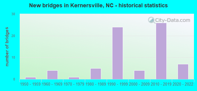
- New bridges - historical statistics
- 11950-1959
- 41960-1969
- 11970-1979
- 51980-1989
- 241990-1999
- 42000-2009
- 262010-2019
- 72020-2022

- Reconstructed bridges - Historical Statistics
- 11950-1959
- 01960-1969
- 01970-1979
- 01980-1989
- 11990-1999


- Bridge Condition - Deck
- 7.7%Excellent
- 23.1%Very good
- 53.8%Good
- 15.4%Satisfactory

- Bridge Condition - Superstructure
- 3.8%Excellent
- 38.5%Very good
- 53.8%Good
- 3.8%Satisfactory

- Bridge Condition - Substructure
- 7.7%Excellent
- 23.1%Very good
- 61.5%Good
- 3.8%Satisfactory
- 3.8%Fair

- Bridge Condition - Channel
- 4.3%Very good
- 60.9%Good
- 21.7%Satisfactory
- 13.0%Fair

- Bridge Condition - Culverts
- 35.7%Good
- 35.7%Satisfactory
- 14.3%Fair
- 14.3%Poor
Find on map >> Show street view
Structure Number: 67037, Location: 0.1 MI. S. JCT. SR2042 (Lat: 36.106542, Lng: -80.046450), Route carried "under" structure: Business Interstate 40, Year Built: 2014, Structure Length: 0. m, Average Daily Traffic: 25,000 (year 2013), Truck Traffic: 12%, Features Intersected: SR2601
Minimum Vertical Clearance: 5.57m (18.27ft), Kilometerpoint: 0.000, Lanes on structure: 6, Lanes under structure: 2, Material/Design: Steel, Design/Construction: Stringer/Multi-beam, Length of Maximum Span: 46.3m (151.9ft)
Find on map >> Show street view
Structure Number: 670439, Location: 0.3 MI.S.JCT.SR2640 (Lat: 36.085439, Lng: -80.063694), Route carried "under" structure: Bypass Interstate 40, Year Built: 1990, Structure Length: 0. m, Average Daily Traffic: 27,500 (year 2015), Truck Traffic: 16%, Features Intersected: NC66
Minimum Vertical Clearance: 5.30m (17.39ft), Kilometerpoint: 62.027, Lanes on structure: 5, Lanes under structure: 11, Material/Design: Prestressed concrete, Design/Construction: Stringer/Multi-beam, Length of Maximum Span: 21.0m (68.9ft)
Find on map >> Show street view
Structure Number: 670439, Location: 0.3 MI.S.JCT.SR2640 (Lat: 36.085439, Lng: -80.063694), Route carried "under" structure: Bypass Interstate 40, Year Built: 1990, Structure Length: 0. m, Average Daily Traffic: 27,500 (year 2015), Truck Traffic: 16%, Features Intersected: NC66
Minimum Vertical Clearance: 5.24m (17.19ft), Kilometerpoint: 62.027, Lanes on structure: 5, Lanes under structure: 2, Material/Design: Prestressed concrete, Design/Construction: Stringer/Multi-beam, Length of Maximum Span: 21.0m (68.9ft)
Find on map >> Show street view
Structure Number: 670442, Location: 0.5 MI. S. JCT. NC66 (Lat: 36.087361, Lng: -80.053403), Route carried "under" structure: Bypass Interstate 40, Year Built: 1990, Structure Length: 0. m, Average Daily Traffic: 27,500 (year 2015), Truck Traffic: 16%, Features Intersected: SR2604
Minimum Vertical Clearance: 5.91m (19.39ft), Kilometerpoint: 62.179, Lanes on structure: 2, Lanes under structure: 2, Material/Design: Prestressed concrete, Design/Construction: Stringer/Multi-beam, Length of Maximum Span: 18.8m (61.7ft)
Find on map >> Show street view
Structure Number: 670442, Location: 0.5 MI. S. JCT. NC66 (Lat: 36.087361, Lng: -80.053403), Route carried "under" structure: Bypass Interstate 40, Year Built: 1990, Structure Length: 0. m, Average Daily Traffic: 27,500 (year 2015), Truck Traffic: 16%, Features Intersected: SR2604
Minimum Vertical Clearance: 5.15m (16.90ft), Kilometerpoint: 62.179, Lanes on structure: 2, Lanes under structure: 2, Material/Design: Prestressed concrete, Design/Construction: Stringer/Multi-beam, Length of Maximum Span: 18.8m (61.7ft)
Find on map >> Show street view
Structure Number: 670447, Location: 0.1 MI. E. JCT. SR2637 (Lat: 36.082811, Lng: -80.089828), Route carried "under" structure: Interstate 40, Year Built: 1991, Structure Length: 0. m, Average Daily Traffic: 28,500 (year 2015), Truck Traffic: 16%, Features Intersected: SR2632
Minimum Vertical Clearance: 6.03m (19.78ft), Kilometerpoint: 61.555, Lanes on structure: 2, Lanes under structure: 2, Material/Design: Prestressed concrete, Design/Construction: Stringer/Multi-beam, Length of Maximum Span: 22.5m (73.8ft)
Find on map >> Show street view
Structure Number: 670447, Location: 0.1 MI. E. JCT. SR2637 (Lat: 36.082811, Lng: -80.089828), Route carried "under" structure: Interstate 40, Year Built: 1991, Structure Length: 0. m, Average Daily Traffic: 28,500 (year 2015), Truck Traffic: 16%, Features Intersected: SR2632
Minimum Vertical Clearance: 5.48m (17.98ft), Kilometerpoint: 61.555, Lanes on structure: 2, Lanes under structure: 2, Material/Design: Prestressed concrete, Design/Construction: Stringer/Multi-beam, Length of Maximum Span: 22.5m (73.8ft)
Find on map >> Show street view
Structure Number: 670458, Location: 1.3 MI. N. JCT. SR2632 (Lat: 36.075008, Lng: -80.109550), Route carried "under" structure: Bypass Interstate 40, Year Built: 1992, Structure Length: 0. m, Average Daily Traffic: 28,500 (year 2015), Truck Traffic: 16%, Features Intersected: SR2643
Minimum Vertical Clearance: 5.45m (17.88ft), Kilometerpoint: 61.143, Lanes on structure: 2, Lanes under structure: 2, Material/Design: Prestressed concrete, Design/Construction: Stringer/Multi-beam, Length of Maximum Span: 19.8m (65.0ft)
Find on map >> Show street view
Structure Number: 670458, Location: 1.3 MI. N. JCT. SR2632 (Lat: 36.075008, Lng: -80.109550), Route carried "under" structure: Bypass Interstate 40, Year Built: 1992, Structure Length: 0. m, Average Daily Traffic: 28,500 (year 2015), Truck Traffic: 16%, Features Intersected: SR2643
Minimum Vertical Clearance: 5.18m (16.99ft), Kilometerpoint: 61.143, Lanes on structure: 2, Lanes under structure: 2, Material/Design: Prestressed concrete, Design/Construction: Stringer/Multi-beam, Length of Maximum Span: 19.8m (65.0ft)
Find on map >> Show street view
Structure Number: 670665, Location: .4 MI N. SR 2679 (Lat: 36.075000, Lng: -80.109722), Route carried "under" structure: Interstate 40, Year Built: 2014, Structure Length: 0. m, Average Daily Traffic: 34,250 (year 2018), Truck Traffic: 16%, Features Intersected: SR 2643
Minimum Vertical Clearance: 5.48m (17.98ft), Kilometerpoint: 61.143, Lanes on structure: 3, Lanes under structure: 2, Material/Design: Prestressed concrete, Design/Construction: Stringer/Multi-beam, Length of Maximum Span: 24.3m (79.7ft)
Find on map >> Show street view
Structure Number: 670665, Location: .4 MI N. SR 2679 (Lat: 36.075000, Lng: -80.109722), Route carried "under" structure: Interstate 40, Year Built: 2014, Structure Length: 0. m, Average Daily Traffic: 34,250 (year 2018), Truck Traffic: 16%, Features Intersected: SR 2643
Minimum Vertical Clearance: 5.32m (17.45ft), Kilometerpoint: 61.143, Lanes on structure: 3, Lanes under structure: 2, Material/Design: Prestressed concrete, Design/Construction: Stringer/Multi-beam, Length of Maximum Span: 24.3m (79.7ft)
Find on map >> Show street view
Structure Number: 670678, Location: 0.7 MI. N.JCT.US 421 RAMP (Lat: 36.112869, Lng: -80.130089), Route carried "under" structure: US 421, Year Built: 2020, Structure Length: 0. m, Average Daily Traffic: 26,250 (year 2018), Truck Traffic: 12%, Features Intersected: I-74 NORTHBOUND
Minimum Vertical Clearance: 5.71m (18.73ft), Kilometerpoint: 69.068, Lanes on structure: 2, Lanes under structure: 2, Material/Design: Prestressed concrete, Design/Construction: Stringer/Multi-beam, Length of Maximum Span: 33.2m (108.9ft)
Find on map >> Show street view
Structure Number: 670678, Location: 0.7 MI. N.JCT.US 421 RAMP (Lat: 36.112869, Lng: -80.130089), Route carried "under" structure: US 421, Year Built: 2020, Structure Length: 0. m, Average Daily Traffic: 26,250 (year 2018), Truck Traffic: 12%, Features Intersected: I-74 NORTHBOUND
Minimum Vertical Clearance: 5.48m (17.98ft), Kilometerpoint: 69.068, Lanes on structure: 2, Lanes under structure: 2, Material/Design: Prestressed concrete, Design/Construction: Stringer/Multi-beam, Length of Maximum Span: 33.2m (108.9ft)
Find on map >> Show street view
Structure Number: 670679, Location: 0.6 MI. S.JCT.US 421 RAMP (Lat: 36.112878, Lng: -80.130364), Route carried "under" structure: US 421, Year Built: 2020, Structure Length: 0. m, Average Daily Traffic: 26,250 (year 2018), Truck Traffic: 12%, Features Intersected: I-74 EASTBOUND
Minimum Vertical Clearance: 5.91m (19.39ft), Kilometerpoint: 69.068, Lanes on structure: 5, Lanes under structure: 2, Material/Design: Prestressed concrete continuous, Design/Construction: Stringer/Multi-beam, Length of Maximum Span: 34.1m (111.9ft)
Find on map >> Show street view
Structure Number: 670679, Location: 0.6 MI. S.JCT.US 421 RAMP (Lat: 36.112878, Lng: -80.130364), Route carried "under" structure: US 421, Year Built: 2020, Structure Length: 0. m, Average Daily Traffic: 26,250 (year 2018), Truck Traffic: 12%, Features Intersected: I-74 EASTBOUND
Minimum Vertical Clearance: 5.63m (18.47ft), Kilometerpoint: 69.068, Lanes on structure: 5, Lanes under structure: 2, Material/Design: Prestressed concrete continuous, Design/Construction: Stringer/Multi-beam, Length of Maximum Span: 34.1m (111.9ft)
Find on map >> Show street view
Structure Number: 670681, Location: .4 MI.S.JCT.US.421 N RAMP (Lat: 36.111128, Lng: -80.130539), Route carried "under" structure: Interstate 74, Year Built: 2014, Structure Length: 0. m, Average Daily Traffic: 37,515 (year 2018), Truck Traffic: 7%, Features Intersected: US 421S.RAMP
Minimum Vertical Clearance: 5.61m (18.41ft), Kilometerpoint: 16.154, Lanes on structure: 2, Lanes under structure: 3, Material/Design: Prestressed concrete, Design/Construction: Stringer/Multi-beam, Length of Maximum Span: 37.1m (121.7ft)
Find on map >> Show street view
Structure Number: 670681, Location: .4 MI.S.JCT.US.421 N RAMP (Lat: 36.111128, Lng: -80.130539), Route carried "under" structure: Interstate 74, Year Built: 2014, Structure Length: 0. m, Average Daily Traffic: 37,515 (year 2018), Truck Traffic: 7%, Features Intersected: US 421S.RAMP
Minimum Vertical Clearance: 5.71m (18.73ft), Kilometerpoint: 16.154, Lanes on structure: 2, Lanes under structure: 3, Material/Design: Prestressed concrete, Design/Construction: Stringer/Multi-beam, Length of Maximum Span: 37.1m (121.7ft)
Find on map >> Show street view
Structure Number: 670681, Location: .4 MI.S.JCT.US.421 N RAMP (Lat: 36.111128, Lng: -80.130539), Route carried "under" structure: Interstate 74, Year Built: 2014, Structure Length: 0. m, Average Daily Traffic: 6,970 (year 2018), Truck Traffic: 7%, Features Intersected: US 421S.RAMP
Minimum Vertical Clearance: 5.58m (18.31ft), Kilometerpoint: 16.154, Lanes on structure: 2, Lanes under structure: 2, Material/Design: Prestressed concrete, Design/Construction: Stringer/Multi-beam, Length of Maximum Span: 37.1m (121.7ft)
Find on map >> Show street view
Structure Number: 670682, Location: 0.4 MI.E.OF SR2632 (Lat: 36.109839, Lng: -80.129267), Route carried "under" structure: Interstate 74, Year Built: 2018, Structure Length: 0. m, Average Daily Traffic: 1,000 (year 2018), Features Intersected: SR2657
Minimum Vertical Clearance: 5.79m (19.00ft), Kilometerpoint: 0.000, Lanes on structure: 2, Lanes under structure: 2, Material/Design: Prestressed concrete, Design/Construction: Stringer/Multi-beam, Length of Maximum Span: 33.8m (110.9ft)
Find on map >> Show street view
Structure Number: 670683, Location: 0.3 MI. E.OF SR2632 (Lat: 36.110075, Lng: -80.130472), Route carried "under" structure: Interstate 74, Year Built: 2018, Structure Length: 0. m, Average Daily Traffic: 12,000 (year 2015), Truck Traffic: 16%, Features Intersected: SR2657
Minimum Vertical Clearance: 6.09m (19.98ft), Kilometerpoint: 0.000, Lanes on structure: 2, Lanes under structure: 1, Material/Design: Prestressed concrete, Design/Construction: Stringer/Multi-beam, Length of Maximum Span: 35.0m (114.8ft)
Find on map >> Show street view
Structure Number: 670683, Location: 0.3 MI. E.OF SR2632 (Lat: 36.110075, Lng: -80.130472), Route carried "under" structure: Interstate 7, Year Built: 2018, Structure Length: 0. m, Average Daily Traffic: 12,000 (year 2015), Truck Traffic: 16%, Features Intersected: SR2657
Minimum Vertical Clearance: 7.59m (24.90ft), Kilometerpoint: 0.000, Lanes on structure: 2, Lanes under structure: 2, Material/Design: Prestressed concrete, Design/Construction: Stringer/Multi-beam, Length of Maximum Span: 35.0m (114.8ft)
Find on map >> Show street view
Structure Number: 670683, Location: 0.3 MI. E.OF SR2632 (Lat: 36.110075, Lng: -80.130472), Route carried "under" structure: Interstate 74, Year Built: 2018, Structure Length: 0. m, Average Daily Traffic: 12,000 (year 2015), Truck Traffic: 16%, Features Intersected: SR2657
Minimum Vertical Clearance: 6.88m (22.57ft), Kilometerpoint: 0.000, Lanes on structure: 2, Lanes under structure: 3, Material/Design: Prestressed concrete, Design/Construction: Stringer/Multi-beam, Length of Maximum Span: 35.0m (114.8ft)
Find on map >> Show street view
Structure Number: 670685, Location: .2 MI N I-40 BUSINESS (Lat: 36.111417, Lng: -80.046111), Route carried "under" structure: State highway 1005, Year Built: 2014, Structure Length: 0. m, Average Daily Traffic: 6,800 (year 2013), Truck Traffic: 6%, Features Intersected: SR2601
Minimum Vertical Clearance: 5.15m (16.90ft), Kilometerpoint: 0.000, Lanes on structure: 3, Lanes under structure: 2, Material/Design: Prestressed concrete, Design/Construction: Stringer/Multi-beam, Length of Maximum Span: 32.9m (107.9ft)
Find on map >> Show street view
Structure Number: 810609, Location: 0.3 MI. N. JCT. SR2007 (Lat: 36.091319, Lng: -80.035439), Route carried "under" structure: Interstate 40, Year Built: 1990, Structure Length: 0. m, Average Daily Traffic: 27,500 (year 2015), Truck Traffic: 16%, Features Intersected: SR1860
Minimum Vertical Clearance: 5.21m (17.09ft), Kilometerpoint: 62.606, Lanes on structure: 2, Lanes under structure: 2, Material/Design: Prestressed concrete, Design/Construction: Stringer/Multi-beam, Length of Maximum Span: 20.4m (66.9ft)
Find on map >> Show street view
Structure Number: 810609, Location: 0.3 MI. N. JCT. SR2007 (Lat: 36.091319, Lng: -80.035439), Route carried "under" structure: Interstate 40, Year Built: 1990, Structure Length: 0. m, Average Daily Traffic: 27,500 (year 2015), Truck Traffic: 16%, Features Intersected: SR1860
Minimum Vertical Clearance: 5.39m (17.68ft), Kilometerpoint: 62.606, Lanes on structure: 2, Lanes under structure: 2, Material/Design: Prestressed concrete, Design/Construction: Stringer/Multi-beam, Length of Maximum Span: 20.4m (66.9ft)