Bridge Statistics for Kinston, North Carolina (NC)
Condition, Traffic, Stress, Structural Evaluation, Project Costs
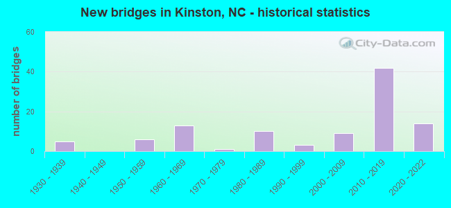
- New bridges - historical statistics
- 51930-1939
- 61950-1959
- 131960-1969
- 11970-1979
- 101980-1989
- 31990-1999
- 92000-2009
- 422010-2019
- 142020-2022


- Bridge Condition - Deck
- 31.7%Very good
- 53.3%Good
- 15.0%Satisfactory

- Bridge Condition - Superstructure
- 35.0%Very good
- 43.3%Good
- 18.3%Satisfactory
- 3.3%Fair

- Bridge Condition - Substructure
- 30.0%Very good
- 35.0%Good
- 26.7%Satisfactory
- 8.3%Fair

- Bridge Condition - Channel
- 8.1%Very good
- 62.9%Good
- 24.2%Satisfactory
- 3.2%Fair
- 1.6%Poor

- Bridge Condition - Culverts
- 9.1%Excellent
- 4.5%Very good
- 45.5%Good
- 27.3%Satisfactory
- 9.1%Fair
- 4.5%Poor
Find on map >> Show street view
Structure Number: 1070198, Location: 0.7 MI.W. JCT.SR1575 (Lat: 35.311489, Lng: -77.650772), Route carried "under" structure: US 258, Year Built: 2012, Structure Length: 0. m, Average Daily Traffic: 6,000 (year 2018), Truck Traffic: 12%, Features Intersected: NC148W
Minimum Vertical Clearance: 5.56m (18.24ft), Kilometerpoint: 0.000, Lanes on structure: 4, Lanes under structure: 3, Material/Design: Steel, Design/Construction: Stringer/Multi-beam, Length of Maximum Span: 44.8m (147.0ft)
Find on map >> Show street view
Structure Number: 1070198, Location: 0.7 MI.W. JCT.SR1575 (Lat: 35.311489, Lng: -77.650772), Route carried "under" structure: US 258, Year Built: 2012, Structure Length: 0. m, Average Daily Traffic: 6,000 (year 2018), Truck Traffic: 12%, Features Intersected: NC148W
Minimum Vertical Clearance: 5.81m (19.06ft), Kilometerpoint: 0.000, Lanes on structure: 4, Lanes under structure: 2, Material/Design: Steel, Design/Construction: Stringer/Multi-beam, Length of Maximum Span: 44.8m (147.0ft)
Find on map >> Show street view
Structure Number: 1070199, Location: 0.7 MI.W. OF JCT.SR1575 (Lat: 35.311319, Lng: -77.650672), Route carried "under" structure: US 258, Year Built: 2012, Structure Length: 0. m, Average Daily Traffic: 6,000 (year 2018), Truck Traffic: 12%, Features Intersected: NC148E
Minimum Vertical Clearance: 5.58m (18.31ft), Kilometerpoint: 0.000, Lanes on structure: 4, Lanes under structure: 2, Material/Design: Steel, Design/Construction: Stringer/Multi-beam, Length of Maximum Span: 44.8m (147.0ft)
Find on map >> Show street view
Structure Number: 1070199, Location: 0.7 MI.W. OF JCT.SR1575 (Lat: 35.311319, Lng: -77.650672), Route carried "under" structure: US 258, Year Built: 2012, Structure Length: 0. m, Average Daily Traffic: 6,000 (year 2018), Truck Traffic: 12%, Features Intersected: NC148E
Minimum Vertical Clearance: 5.30m (17.39ft), Kilometerpoint: 0.000, Lanes on structure: 4, Lanes under structure: 3, Material/Design: Steel, Design/Construction: Stringer/Multi-beam, Length of Maximum Span: 44.8m (147.0ft)
Find on map >> Show street view
Structure Number: 10702, Location: 3.8 MI. W. JCT US258 (Lat: 35.275278, Lng: -77.678611), Route carried "under" structure: US 70, Year Built: 2014, Structure Length: 0. m, Average Daily Traffic: 12,250 (year 2019), Truck Traffic: 14%, Features Intersected: NC148 EBL
Minimum Vertical Clearance: 5.41m (17.75ft), Kilometerpoint: 0.000, Lanes on structure: 2, Lanes under structure: 3, Material/Design: Prestressed concrete continuous, Design/Construction: Stringer/Multi-beam, Length of Maximum Span: 31.6m (103.7ft)
Find on map >> Show street view
Structure Number: 10702, Location: 3.8 MI. W. JCT US258 (Lat: 35.275278, Lng: -77.678611), Route carried "under" structure: US 70, Year Built: 2014, Structure Length: 0. m, Average Daily Traffic: 12,250 (year 2019), Truck Traffic: 14%, Features Intersected: NC148 EBL
Minimum Vertical Clearance: 5.53m (18.14ft), Kilometerpoint: 0.000, Lanes on structure: 2, Lanes under structure: 2, Material/Design: Prestressed concrete continuous, Design/Construction: Stringer/Multi-beam, Length of Maximum Span: 31.6m (103.7ft)
Find on map >> Show street view
Structure Number: 1070201, Location: 1.6 MI. E. JCT. SR1519 (Lat: 35.271083, Lng: -77.668083), Route carried "under" structure: State highway 2003, Year Built: 2013, Structure Length: 0. m, Average Daily Traffic: 100 (year 2012), Features Intersected: US70W
Minimum Vertical Clearance: 4.82m (15.81ft), Kilometerpoint: 0.000, Lanes on structure: 2, Lanes under structure: 3, Material/Design: Steel, Design/Construction: Stringer/Multi-beam, Length of Maximum Span: 38.7m (127.0ft)
Find on map >> Show street view
Structure Number: 1070202, Location: 1.6 MI. E. JCT. SR1324 (Lat: 35.270306, Lng: -77.668083), Route carried "under" structure: State highway 2003, Year Built: 2013, Structure Length: 0. m, Average Daily Traffic: 100 (year 2012), Features Intersected: US70E
Minimum Vertical Clearance: 4.80m (15.75ft), Kilometerpoint: 0.000, Lanes on structure: 2, Lanes under structure: 3, Material/Design: Steel, Design/Construction: Stringer/Multi-beam, Length of Maximum Span: 38.7m (127.0ft)
Find on map >> Show street view
Structure Number: 107021, Location: 1.4 MI. E. JCT. NC58 (Lat: 35.333639, Lng: -77.551139), Route carried "under" structure: State lands road 1004, Year Built: 2020, Structure Length: 0. m, Average Daily Traffic: 2,400 (year 2018), Truck Traffic: 7%, Features Intersected: NC148W
Minimum Vertical Clearance: 5.42m (17.78ft), Kilometerpoint: 0.000, Lanes on structure: 2, Lanes under structure: 2, Material/Design: Steel, Design/Construction: Stringer/Multi-beam, Length of Maximum Span: 40.8m (133.9ft)
Find on map >> Show street view
Structure Number: 1070211, Location: 1.4 MI. E. JCT. NC58 (Lat: 35.350278, Lng: -77.551167), Route carried "under" structure: State lands road 1004, Year Built: 2020, Structure Length: 0. m, Average Daily Traffic: 1,500 (year 2017), Truck Traffic: 7%, Features Intersected: NC148E
Minimum Vertical Clearance: 5.04m (16.54ft), Kilometerpoint: 0.000, Lanes on structure: 2, Lanes under structure: 2, Material/Design: Steel, Design/Construction: Stringer/Multi-beam, Length of Maximum Span: 40.8m (133.9ft)
Find on map >> Show street view
Structure Number: 1070212, Location: 2.0 MI. E. JCT. NC58 (Lat: 35.319278, Lng: -77.535444), Route carried "under" structure: State lands road 1732, Year Built: 2020, Structure Length: 0. m, Average Daily Traffic: 860 (year 2016), Truck Traffic: 6%, Features Intersected: NC148
Minimum Vertical Clearance: 4.97m (16.31ft), Kilometerpoint: 0.000, Lanes on structure: 2, Lanes under structure: 2, Material/Design: Prestressed concrete, Design/Construction: Stringer/Multi-beam, Length of Maximum Span: 30.1m (98.8ft)
Find on map >> Show street view
Structure Number: 1070216, Location: 3.5 MI. E. JCT. NC58 (Lat: 35.319111, Lng: -77.517083), Route carried "under" structure: State lands road 1735, Year Built: 2020, Structure Length: 0. m, Average Daily Traffic: 1,600 (year 2017), Truck Traffic: 6%, Features Intersected: NC148
Minimum Vertical Clearance: 5.05m (16.57ft), Kilometerpoint: 0.000, Lanes on structure: 2, Lanes under structure: 2, Material/Design: Steel, Design/Construction: Stringer/Multi-beam, Length of Maximum Span: 30.1m (98.8ft)
Find on map >> Show street view
Structure Number: 1070218, Location: 0.5 MI. W. JCT. NC11 (Lat: 35.316914, Lng: -77.483603), Route carried "under" structure: State highway 1720, Year Built: 2020, Structure Length: 0. m, Average Daily Traffic: 520 (year 2018), Truck Traffic: 6%, Features Intersected: NC148
Minimum Vertical Clearance: 5.31m (17.42ft), Kilometerpoint: 0.000, Lanes on structure: 2, Lanes under structure: 2, Material/Design: Prestressed concrete, Design/Construction: Slab, Length of Maximum Span: 31.0m (101.7ft)
Find on map >> Show street view
Structure Number: 1070219, Location: 0.5 MI. W. JCT. NC11 (Lat: 35.332678, Lng: -77.545964), Route carried "under" structure: State highway 1720, Year Built: 2020, Structure Length: 0. m, Average Daily Traffic: 520 (year 2018), Truck Traffic: 6%, Features Intersected: NC148W
Minimum Vertical Clearance: 5.13m (16.83ft), Kilometerpoint: 0.000, Lanes on structure: 2, Lanes under structure: 2, Material/Design: Prestressed concrete, Design/Construction: Stringer/Multi-beam, Length of Maximum Span: 34.7m (113.8ft)