Bridge Statistics for Knoxville, Iowa (IA)
Condition, Traffic, Stress, Structural Evaluation, Project Costs
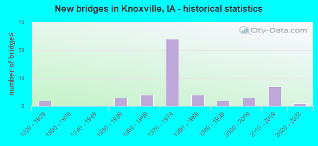
- New bridges - historical statistics
- 21920-1929
- 31950-1959
- 41960-1969
- 241970-1979
- 41980-1989
- 21990-1999
- 32000-2009
- 72010-2019
- 12020-2022


- Bridge Condition - Deck
- 11.8%Excellent
- 8.8%Very good
- 32.4%Good
- 29.4%Satisfactory
- 11.8%Fair
- 5.9%Poor

- Bridge Condition - Superstructure
- 11.8%Excellent
- 23.5%Very good
- 17.6%Good
- 26.5%Satisfactory
- 14.7%Fair
- 5.9%Poor

- Bridge Condition - Substructure
- 11.8%Excellent
- 17.6%Very good
- 26.5%Good
- 44.1%Satisfactory

- Bridge Condition - Channel
- 13.8%Very good
- 31.0%Good
- 48.3%Satisfactory
- 3.4%Fair
- 3.4%Poor

- Bridge Condition - Culverts
- 50.0%Good
- 33.3%Fair
- 16.7%Poor
Find on map >> Show street view
Structure Number: 60349, Location: At jct. Iowa 14 (Lat: 41.303781, Lng: -93.109986), Route carried "under" structure: State highway 14, Year Built: 1978, Structure Length: 0. m, Average Daily Traffic: 3,000 (year 2020), Truck Traffic: 9%, Features Intersected: IA 14, Facility Carried by Structure: SB IA 5 & IA 92
Minimum Vertical Clearance: 30+ m (98+ ft), Kilometerpoint: 68.598, Lanes on structure: 2, Lanes under structure: 4, Material/Design: Steel continuous, Design/Construction: Stringer/Multi-beam, Length of Maximum Span: 36.0m (118.1ft)
Find on map >> Show street view
Structure Number: 6035, Location: AT Jct. Iowa 14 (Lat: 41.303775, Lng: -93.109011), Route carried "under" structure: State highway 14, Year Built: 1978, Structure Length: 0. m, Average Daily Traffic: 3,000 (year 2020), Truck Traffic: 9%, Features Intersected: IA 14, Facility Carried by Structure: NB IA 5 & IA 92
Minimum Vertical Clearance: 30+ m (98+ ft), Kilometerpoint: 68.627, Lanes on structure: 2, Lanes under structure: 4, Material/Design: Steel continuous, Design/Construction: Stringer/Multi-beam, Length of Maximum Span: 36.0m (118.1ft)
Find on map >> Show street view
Structure Number: 60351, Location: 1.0 MI. S OF JCT IOWA #14 (Lat: 41.299700, Lng: -93.091400), Route carried "under" structure: County highway , Year Built: 1978, Structure Length: 0. m, Average Daily Traffic: 75 (year 2014), Features Intersected: 135TH PLACE, Facility Carried by Structure: IA 92 EB & IA 5 SB
Minimum Vertical Clearance: 30+ m (98+ ft), Kilometerpoint: 5.700, Lanes on structure: 2, Lanes under structure: 2, Material/Design: Prestressed concrete, Design/Construction: Stringer/Multi-beam, Length of Maximum Span: 17.4m (57.1ft)
Find on map >> Show street view
Structure Number: 60352, Location: 1.0 MI. S OF JCT. IA 14 (Lat: 41.299958, Lng: -93.090931), Route carried "under" structure: County highway , Year Built: 1978, Structure Length: 0. m, Average Daily Traffic: 75 (year 2014), Features Intersected: 135TH PLACE, Facility Carried by Structure: IA 92 WB & IA 5 NB
Minimum Vertical Clearance: 30+ m (98+ ft), Kilometerpoint: 5.728, Lanes on structure: 2, Lanes under structure: 2, Material/Design: Prestressed concrete, Design/Construction: Stringer/Multi-beam, Length of Maximum Span: 17.4m (57.1ft)
Find on map >> Show street view
Structure Number: 60355, Location: 2.0 MI. E OF E JCT IOWA 5 (Lat: 41.300647, Lng: -93.033761), Route carried "under" structure: County highway , Year Built: 1978, Structure Length: 0. m, Average Daily Traffic: 180 (year 2014), Features Intersected: 165TH AVE, Facility Carried by Structure: IA 92
Minimum Vertical Clearance: 30+ m (98+ ft), Kilometerpoint: 3.380, Lanes on structure: 2, Lanes under structure: 2, Material/Design: Prestressed concrete, Design/Construction: Stringer/Multi-beam, Length of Maximum Span: 18.6m (61.0ft)
Find on map >> Show street view
Structure Number: 60356, Location: 2.0 mi. N Jct. IA 14 (Lat: 41.320364, Lng: -93.138150), Route carried "under" structure: State highway 5, Year Built: 1978, Structure Length: 0. m, Average Daily Traffic: 4,410 (year 2020), Truck Traffic: 16%, Features Intersected: IA 5 & IA 92, Facility Carried by Structure: MCKIMBER STREET
Minimum Vertical Clearance: 30+ m (98+ ft), Kilometerpoint: 103.276, Lanes on structure: 1, Lanes under structure: 4, Material/Design: Steel continuous, Design/Construction: Stringer/Multi-beam, Length of Maximum Span: 46.6m (152.9ft)