Bridge Statistics for Kosciusko, Mississippi (MS)
Condition, Traffic, Stress, Structural Evaluation, Project Costs
- National Bridge Inventory (NBI) Statistics
- 45Number of bridges
- 594ft / 181mTotal length
- $3,160,281,000Total costs
- 74,183Total average daily traffic
- 9,793Total average daily truck traffic
- 77,973Total future (year 2030) average daily traffic
- National Bridge Inventory (NBI) Registered Bridges for Kosciusko
- No street view available for this location
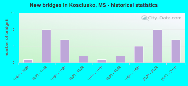
- New bridges - historical statistics
- 11930-1939
- 101940-1949
- 71950-1959
- 21960-1969
- 11970-1979
- 21980-1989
- 51990-1999
- 102000-2009
- 72010-2019

- Reconstructed bridges - Historical Statistics
- 11990-1999
- 12000-2009


- Bridge Condition - Deck
- 37.5%Very good
- 29.2%Good
- 25.0%Satisfactory
- 8.3%Fair

- Bridge Condition - Superstructure
- 42.3%Very good
- 26.9%Good
- 23.1%Satisfactory
- 7.7%Fair

- Bridge Condition - Substructure
- 42.3%Very good
- 26.9%Good
- 23.1%Satisfactory
- 7.7%Fair

- Bridge Condition - Channel
- 40.5%Very good
- 10.8%Good
- 37.8%Satisfactory
- 8.1%Fair
- 2.7%Poor

- Bridge Condition - Culverts
- 52.6%Very good
- 26.3%Good
- 15.8%Satisfactory
- 5.3%Fair
Find on map >> Show street view
Structure Number: SA0400000000176, Location: SEC 1 T13N R 6E (Lat: 33.016944, Lng: -89.640556), Route carried "on" structure: County highway 74, Year Built: 2011, Status: Open, Structure Length: 1.50m (4.92ft), Average Daily Traffic: 100 (year 2012), Truck Traffic: 8%, Average Future Daily Traffic: 150 (year 2035), Design Load: HS 20, Features Intersected: BCH OF PONY BRANCH, Facility Carried by Structure: CO. ROAD 4142
Minimum Vertical Clearance: 30+ m (98+ ft), Kilometerpoint: 3.218, Lanes on structure: 2, Owner: County Highway Agency, Approaching Roadway Width: 7.9m (25.9ft), Skew: 3 degrees, Material/Design: Concrete, Design/Construction: Culvert, Number Of Spans In Main Unit: 2, Length of Maximum Span: 7.0m (23.0ft)
Condition: Channel: Very good, Culverts: Very good, Structural Evaluation: Equal to present desirable criteria, Waterway Adequacy: Superior to present desirable criteria, Approach Roadway Alignment: Equal to present desirable criteria, Length Of Structure Improvement: 1.22m (4.00ft), Designated Inspection Frequency: Every 24 months, Inspection Date: January 2021, Bridge Improvement Cost: $250,000, Roadway Improvement Cost: $100,000, Total Project Cost: $350,000 ( Estimate for 2019)
Find on map >> Show street view
Structure Number: SA040000000A078, Location: SEC 24 T14N R 7E (Lat: 33.058156, Lng: -89.526917), Route carried "on" structure: County highway 141, Year Built: 2019, Status: Open, Structure Length: 0.61m (2.00ft), Average Daily Traffic: 60 (year 2007), Truck Traffic: 8%, Average Future Daily Traffic: 90 (year 2030), Features Intersected: GRAPEVINE CREEK, Facility Carried by Structure: CO. ROAD 1215
Minimum Vertical Clearance: 30+ m (98+ ft), Kilometerpoint: 3.379, Lanes on structure: 2, Owner: County Highway Agency, Approaching Roadway Width: 6.1m (20.0ft), Material/Design: Steel, Design/Construction: Culvert, Number Of Spans In Main Unit: 2, Length of Maximum Span: 2.9m (9.5ft)
Condition: Channel: Very good, Culverts: Very good, Structural Evaluation: Equal to present desirable criteria, Waterway Adequacy: Equal to present desirable criteria, Approach Roadway Alignment: Equal to present desirable criteria, Length Of Structure Improvement: 1.83m (6.00ft), Designated Inspection Frequency: Every 24 months, Inspection Date: June 2019, Bridge Improvement Cost: $250,000, Roadway Improvement Cost: $100,000, Total Project Cost: $350,000 ( Estimate for 2019)
Find on map >> Show street view
Structure Number: SA040000000A105, Location: SEC 35 T15N R 6E B (Lat: 33.115161, Lng: -89.652069), Route carried "on" structure: County highway 31, Year Built: 2016, Status: Open, Structure Length: 5.00m (16.40ft), Average Daily Traffic: 180 (year 2016), Truck Traffic: 8%, Average Future Daily Traffic: 270 (year 2036), Design Load: HL 93, Features Intersected: HOSSPEN CREEK, Facility Carried by Structure: CO. ROAD 3024
Minimum Vertical Clearance: 30+ m (98+ ft), Kilometerpoint: 2735.000, Lanes on structure: 2, Owner: County Highway Agency, Approaching Roadway Width: 9.1m (29.9ft), Skew: 3 degrees, Material/Design: Concrete, Design/Construction: Channel Beam, Number Of Spans In Main Unit: 5, Length of Maximum Span: 12.2m (40.0ft), Curb or Sidewalk Widths: Left: 0.4m (1.3ft), Right: 0.4m (1.3ft), Curb-To-Curb Width: 8.5m (27.9ft), Out-to-Out Width: 9.3m (30.5ft)
Condition: Deck: Very good, Superstructure: Very good, Substructure: Very good, Channel: Very good, Operating Rating: 43.7 metric tons, Method Used To Determine Operating Rating: Load and Resistance Factor Rating (LRFR) rating reported by rating factor(RF) method using HL-93 loadings, Inventory Rating: 33.7 metric tons, Method Used To Determine Inventory Rating: Load and Resistance Factor Rating (LRFR) rating reported by rating factor(RF) method using HL-93 loadings, Structural Evaluation: Equal to present desirable criteria, Deck Geometry: Equal to present minimum criteria, Waterway Adequacy: Equal to present desirable criteria, Approach Roadway Alignment: Better than present minimum criteria, Length Of Structure Improvement: 5.00m (16.40ft), Designated Inspection Frequency: Every 24 months, Inspection Date: January 2021, Bridge Improvement Cost: $574,000, Roadway Improvement Cost: $100,000, Total Project Cost: $674,000 ( Estimate for 2019), Deck Structure Type: Concrete Precast Panels, Wearing Surface/Protective System: Wearing Surface: Monolithic Concrete
Find on map >> Show street view
Structure Number: SA040000000A106, Location: SEC 35 T15N R 6E B (Lat: 33.114792, Lng: -89.649606), Route carried "on" structure: County highway 13, Year Built: 2016, Status: Open, Structure Length: 4.27m (14.01ft), Average Daily Traffic: 180 (year 2016), Truck Traffic: 8%, Average Future Daily Traffic: 270 (year 2036), Design Load: HL 93, Features Intersected: SUGAR CREEK, Facility Carried by Structure: CO. ROAD 3024
Minimum Vertical Clearance: 30+ m (98+ ft), Kilometerpoint: 305.700, Lanes on structure: 2, Owner: County Highway Agency, Approaching Roadway Width: 9.1m (29.9ft), Material/Design: Concrete, Design/Construction: Channel Beam, Number Of Spans In Main Unit: 5, Length of Maximum Span: 12.2m (40.0ft), Curb or Sidewalk Widths: Left: 0.5m (1.6ft), Right: 0.5m (1.6ft), Curb-To-Curb Width: 8.5m (27.9ft), Out-to-Out Width: 9.3m (30.5ft)
Condition: Deck: Very good, Superstructure: Very good, Substructure: Very good, Channel: Very good, Operating Rating: 43.7 metric tons, Method Used To Determine Operating Rating: Load and Resistance Factor Rating (LRFR) rating reported by rating factor(RF) method using HL-93 loadings, Inventory Rating: 33.7 metric tons, Method Used To Determine Inventory Rating: Load and Resistance Factor Rating (LRFR) rating reported by rating factor(RF) method using HL-93 loadings, Structural Evaluation: Equal to present desirable criteria, Deck Geometry: Equal to present minimum criteria, Waterway Adequacy: Equal to present desirable criteria, Approach Roadway Alignment: Better than present minimum criteria, Length Of Structure Improvement: 4.27m (14.01ft), Designated Inspection Frequency: Every 24 months, Inspection Date: January 2021, Bridge Improvement Cost: $490,000, Roadway Improvement Cost: $100,000, Total Project Cost: $590,000 ( Estimate for 2019), Deck Structure Type: Concrete Precast Panels, Wearing Surface/Protective System: Wearing Surface: Monolithic Concrete